After Heather and I explored Brittany we headed north to join 35 other van Stolks and their partners in Ireland for a family reunion. No, we aren’t Irish, but the Dutch family wanted to vacation outside of the Netherlands and the American part of the family wanted to spend time in a scenic part of northern Europe. Ireland was a delightful compromise. We converged on a holiday cottage complex just north of Dublin where we spent a convivial time moving from porch to porch catching up on years of news. The whole bunch of us set out in a rather unruly convoy to highlights like Newgrange, Slane Castle, and a sheep herding demonstration further afield in Glendalough.

Glendalough is a jewel of a lake in the mountains south of Dublin in County Wicklow, a rugged contrast to the gently rolling green hills usually associated with Ireland. We all oohed and aahed at the sheepdogs and their puppies, and then a smaller group of cousins set out on a hike to work off the cabin fever.We did the “white trail” around the upper and lower lakes at Glendalough. It’s a stunning 7.8 mile loop! We did it counter-clockwise, which results in a gentler upward climb. If you hike this clockwise you have to climb up the hundreds of wooden stairs on the eastern side of the lake… not my idea of a great time. Going counter-clockwise also results in beautiful views of the monastery site from the top of the cliff!

Trail map from Alltrails.com
It turned out to be a lesson in the importance of looking at the scale of the contour lines on the topographic map at the visitor’s center. We thought “oh, we only cross one topo line on the map, the trail must stay close to the lake.” Well it turned out that the distance between topo lines on that map was 0.4 kilometers – about 1,500 feet. My cousins with a strong aversion to heights were absolute troopers. The views from the top were amazing!

Hanging out in a textbook-perfect glacial valley, with the old mine buildings in the background. Halfway to the top!

At the top! Two cousins aren’t in this picture because they didn’t fancy spending more time at the top of this cliff than absolutely necessary and they also are much fitter than the rest of us.

The southern cliff is topped with blanket bogs. They’re an extremely soggy and sensitive landscape, so the park put in a couple miles of boardwalk to minimize human impact. I felt like I was somewhere in Tolkien’s Middle Earth!
Glendalough seems like a valley outside time, once you step away from the tourist shops. The paths take you by an old monastery, streams in strange mossy landscapes, and the lake itself surround by hills and forests. It came as a surprise to me when we found the remnants of an abandoned mine at the eastern end of the lake.

It turns out that between the 1790s and the 1920s this area a hive of mining activity. You can easily tell what the miners were looking for in the landscape – the scars of white quartz rubble are the giveaway (see the slope on the right side of the photo above). The miners were looking for lead, silver, and zinc. Specifically, they found it in the minerals galena and sphalerite.

Image of galena (dark gray) and sphalerite (orange-ish brown) in quartz (white) from the Glendalough mine from the National Museum of Ireland.
Galena is a mineral composed of equal amounts of lead and sulphur (its formula is PbS). In this area silver substitutes for lead in the crystal structure around 5% of the time, making it a valuable ore for silver as well as lead. Sphalerite is made of equal amounts of zinc and sulphur (formula is ZnS). But how did they get here, and why are they only found in the quartz?
Let’s take a step back an look at the history of the local landscape over the past few million years, courtesy of an interpretive sign at Glendalough’s ranger center. The information is great so I didn’t bother re-typing it, but you may have to click on the image and zoom to read it if you’re reading this on your phone.
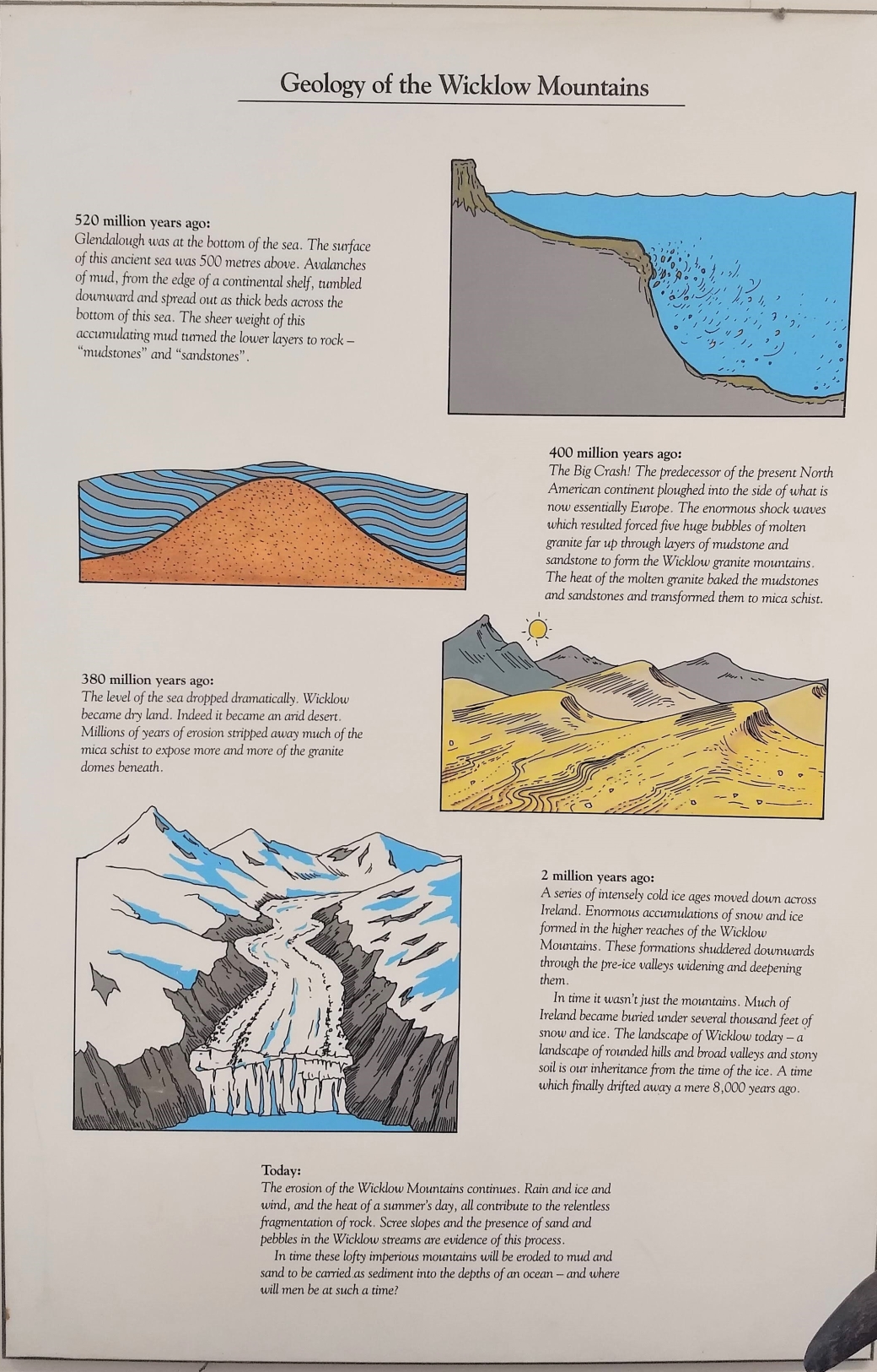
Photo of an interpretive sign of Glendalough’s geology at the ranger center.
Two types of rocks form the foundation of this landscape: a metamorphosed version of mudstone or shale called schist, and the granite which muscled its way up into those rocks during the Caledonian orogeny. Remember that from a few blog posts back? This Irish granite is a cousin of sorts to the granite that became the Mont Saint Michel. It too was formed as the heat created by the collision of Laurentia, Baltica, and Avalonia created magma that rose up into overlying rocks and cooled into huge lumps of granite (called batholiths in geologist jargon). In the map below, the granite is shown in red. It also shows just how many mines were once active in this area!

A map of mining activities near Glendalough – we hiked past #7 and #8, Glendalough Valley mine and Van Diemen’s land mine. This map also shows the geologic contrast in the region between the schist (light pink) to the east and the granite (red) to the west of the lake. This map is from https://secure.dccae.gov.ie/GSI_DOWNLOAD/Geoheritage/Reports/WW065_Glendalough_Glendasan_Glenmalure_District_Overview.pdf
This particular batholith is called the Leinster Granite batholith and underlies much of County Wicklow. It’s harder than the surrounding schist and creates more rugged cliffs when assaulted with millions of years of wind, rain, and glaciers. In the Wicklow mountains the granite slopes tend to be covered in boulder fields, and the schist slopes are covered in heather and other creeping low bushes. Neither type of rock weathers into particularly inviting soil for plants, at least not in the geologically short period since the last Ice Age.

- Rock specimens that I couldn’t resist at Glendalough: Schist with neat protruding flexible sheet of mica (left), granite (center), bits of waste quartz from the mining operation (right)
Here’s a map of the mine site that is #7 on the map above, and the first area we came to on our hike. This map was put together by the educational group “Glens of Lead”. This group put up some great historical signs in along the park about how the old mining operations worked.

And here’s a map of the second area on the hike, #8 on the map.

Very little of the original infrastructure remains today, except for the stone buildings at the Glendalough mine site and the bright white quartz of the tailings rubble from the mines. The shafts and tunnels have been blocked off and the old tramways completely dismantled. The site seems very wild again.

Standing on the schist side of the valley, looking over to the steep granite cliffs and the piles of quartz tailings below the exits of the old mine shafts 1,000 feet below.


Above right: granite with vein of hydrothermal mineralization (foot for scale) in the mining area, compared with schist exposed at the top of the cliff on the south side of the lake.
But how does lead ore get into quartz veins? I’ve written about continental collisions and granite before in this blog, but not really about smaller processes of metamorphism. It’s time to fire up MS Paint again.

Magma bodies (red) rise off of the subducting oceanic crust and cool into intrusive igneous rocks (pink). Water (blue speckles) in the oceanic crust allows the crust to melt at lower temperatures than the surrounding rock, and travels upwards as a part of the magma. Diagram by C. van Stolk.
Back around 300 million years ago, the ocean Iapetus was closing as the old continents Laurentia, Gondwana, and Avalonia moved towards each other. The oceanic crust under Iapetus had to go somewhere; it subducted under the continents. After a few million years of being underwater that oceanic crust was pretty soggy as rocks go. The conveyor belt of plate tectonics drove the heavy oceanic crust down under the lighter continental crust. It began to melt as it sank beneath the continent and into the upper layer of Earth’s mantle called the asthenosphere.
It turns out that this water trapped in the crust is kind of the “secret sauce” of metamorphism. The presence of water allows rocks to melt at lower temperatures than they would otherwise. Metamorphism boils down to two variables – heat and pressure. Both increase vertically with depth in the earth’s crust. Pressure also increases horizontally in collision zones. In the presence of equal amounts of heat and pressure, wet rock will melt to a greater degree than dry rock.
Anyone who has taken a ride in a hot air balloon learns that heat rises – the hot air in the balloon keeps the passengers aloft in the cooler surrounding air. The blobs of magma rising from the subducting wet oceanic crust are much like extremely dense, slow-motion hot air balloons – they rise through any weakness they can find in the surrounding cooler and drier rock. The blobs of magma become batholiths of intrusive rock when they cool, like the granite here. As the granite cooled, the heat had to go somewhere, just as the oceanic plate had to go somewhere as the ocean closed. The magma “cooked” the shales that surrounded it into the metamorphosed version – schist (see purple “contact metamorphism” on the diagram below). However the story of the water that magma contained isn’t over.

If water can’t fit into the crystal structure of the magma as it cools into intrusive igneous rocks, it is released from the melt. It takes along ions that can be dissolved in it and travels into cracks in the surrounding rock. Often these “cracks” are caused by faults or by joints caused by horizontal pressure. One of the most common elements carried along this way is silica, which in combination with oxygen forms quartz veins as it cools. This mineral-rich hot water is called a “hydrothermal solution”.

Diagram of hydrothermal alteration from https://opentextbc.ca/geology. (a) Shows a magma body that has risen into cooler rock and is “cooking” it shown by the purple aureole. (b) Shows magmatic water being released from the magma body through veins. (c) Shows how groundwater moving past the magma body can also carry dissolved minerals away from it to other locations.
As the hydrothermal solution rises and cools, minerals form out of the solution like rock sugar forming out of hot sugar syrup as it cools down. Not every part of the solution is really well mixed – some parts of the solution are like oil and water and stay somewhat distinct as they travel together. Examples of this are silicate minerals (i.e. quartz SiO2, feldspar KAlSi3O8 – NaAlSi3O8 – CaAl2Si2O8) and sulphide minerals (galena PbS, sphalerite ZnS). As the solution cools, these two types of minerals form adjacent but separate structures.
So here at Glendalough, you have granite and schist cut through with veins of hydrothermal rocks that contain chunks of sulphide ore minerals in the more abundant quartz. The miners followed these hydrothermal veins to find the valuable ore, and discarded the attractive but comparably worthless quartz in tailings piles at the site after the rock was put through a huge crusher to break out the softer sulphide ore minerals. I was sorry to notice that they were so thorough that a casual geologist really can’t find any of that ore nowadays.
I was happy enough to take away great memories, beautiful views, and a few new rocks in my pocket.
Resources:
A good brief history of the mines here: https://www.mindat.org/article.php/368/A+History+of+Glendalough
Brief intro to geology of Glendalough here: https://www.wicklowmountainsnationalpark.ie/nature/geology/
https://www.gsi.ie/en-ie/geoscience-topics/geology/Pages/Geology-of-Ireland.aspx
detailed geological survey of mining in the region: https://secure.dccae.gov.ie/GSI_DOWNLOAD/Geoheritage/Reports/WW065_Glendalough_Glendasan_Glenmalure_District_Overview.pdf
detailed geological survey of mining at Glendalough specifically: https://secure.dccae.gov.ie/GSI_DOWNLOAD/Geoheritage/Reports/WW025_Glendalough.pdf
geological map of Ireland: https://secure.dccae.gov.ie/GSI_DOWNLOAD/Bedrock/Other/GSI_BedrockGeologyOfIreland_A4.pdf
Maps of lead mining in the area by the local education group “Glens of Lead”: https://www.avenzamaps.com/vendor/209/glens-of-lead
More about the Iapetus Suture, which connects the half of Ireland/Scotland that was once Laurentia (proto-North America) with the half that was once Avalonia (proto-Europe). https://en.wikipedia.org/wiki/Iapetus_Suture
Interesting map of the terranes that make up Ireland: http://www.askaboutireland.ie/reading-room/environment-geography/physical-landscape/Irelands-physical-landsca/the-formation-of-the-phys/
Ireland through geologic time: https://www.gsi.ie/en-ie/education/the-geology-of-ireland/Pages/Ireland-through-geological-time.aspx
Specimen of galena in quartz from the mine: https://www.museum.ie/The-Collections/Documentation-Discoveries/July-2016-(1)/Lead-Bearing-Minerals-from-Glendalough
More about contact metamorphism/hydrothermal alteration/sulfide ore bodies
Contact metamorphism with good diagrams: https://opentextbc.ca/geology/chapter/7-5-contact-metamorphism-and-hydrothermal-processes/
http://www.geologyin.com/2014/11/veins-and-hydrothermal-deposits.html
Overview of sulfide ores: https://uwaterloo.ca/earth-sciences-museum/resources/hydrothermal-minerals
Cliffsnotes version of hydrothermal metamorphism: https://www.cliffsnotes.com/study-guides/geology/metamorphic-rocks/hydrothermal-rocks
Detailed review of ore genesis, including immiscible solutions. https://courses.lumenlearning.com/wmopen-geology/chapter/outcome-ore-and-mineral-resources/

Pingback: Ireland: Rocks of Newgrange | Blue Marble Earth