


Guide to Hiking in Cappadocia’s Stunning Canyons
Introduction to Cappadocia
Cappadocia is a stunning and unique region of rock: canyons, colorful cliff walls, huge rock mesas, crazy rock pillars, historic cave homes & cave churches, river-carved rock tunnels.
Cappadocia is situated on Turkey’s vast Anatolian Plateau in central Turkey. The region is set mainly at an altittude of about 3300 ft/1000 M. Overall the massive plateau is flat and full of low undulating hills. Then suddenly in Cappadocia the plains give way to a series of winding canyons, high mesas and rock pinnacles.
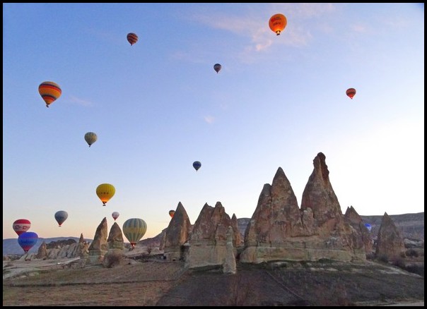
Nowadays Cappadocia is most famous as one of the premiere regions in the world for Hot Air Ballooning, which got underway as a new industry there in the early 2010s. Cappadocia is arguably the most beautiful place for hot air ballooning since the balloons glide over the spectacular canyons and rock formations.
Prior to ballooning, Cappadocia’s most famous tourist draw was its ancient Christian cave churches. The churches were carved into the cliffs and rock pillars during the 100-300s AD, making them over 2000 years old. Two canyons featuring a high concentration of these cave churches are UNESCO World Heritage Sites, making these spots the main draw for most visitors to Cappadocia.
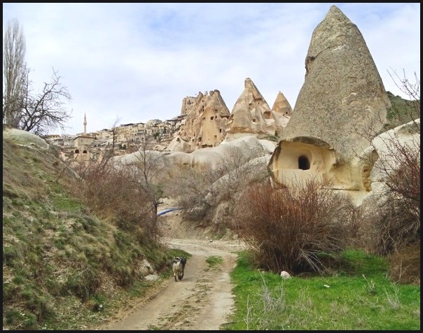
In the midst of the canyons there are several small villages that have developed into tourist towns. They’re filled with small hotels & hostels (many of them offering cave rooms!), restaurants & cafes, and a plethora of shops geared to travelers. The villages include Goreme, Uchisar, Urgup, Ortashir and Cavusin.
I wrote a more extensive introduction to Cappadocia here.
A lesser known highlight of Cappadocia are its many fantastic hiking trails through the beautiful canyons. Before I ever visited Cappadocia in 2020, I had read about visiting the various canyons, however I didn’t realize the great extent of the hiking opportunities until I arrrived in March, 2020, primarily to go Hot Air Ballooning.
After I took my very first wonderful balloon flight, I promptly started exploring the canyons on foot, with help of a fantastic trail map provided by Kamelya Hostel. I was so wow-ed by the beautiful & surprisingly diverse canyons that I vowed to return one day to hike them all again.
So here I am, one year later, in June of 2021, spending two glorious weeks hiking through as many canyons as possible. I’ve re-hiked my favorite routes and also found several other excellent trails (again thanks to the great Kamelya map!).
I decided to write this hiking guide with the hope of inspiring other nature lovers, hikers and outdoor enthusiasts to go hike Cappadocia’s stunning canyons.
The Canyons of Cappadocia
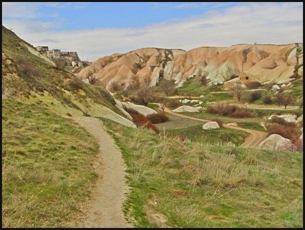
Cappadocia is filled with dozens of canyons. They vary in length and are separated from each other by high flat ridges, many of which offer fantastic panoramic viewpoints down into the canyons and out over the vast plain stretching northward from Goreme.
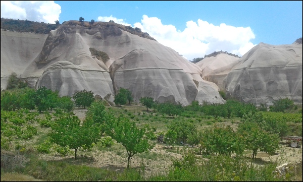
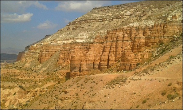
There’s also a high, chunky multi-colored rock mesa running along the east side of the central plain called Aktepe Hill. This massive mesa is one of the most spectacular sights, featuring a flat-ish top and soaring cliffs displaying a multitude of colors: reds, golds, beiges, black and white. Several of the most beautiful & famous canyons run up against that huge rock monolithe, at the base of its high cliffs.
Hiking trails run through the canyon floors, along the ridgetops, on top of the big mesa and midway up the mesa at the base of the high cliffs yet still high above the lower canyons. In some places, trails connect the lower canyon and upper ridge trails.
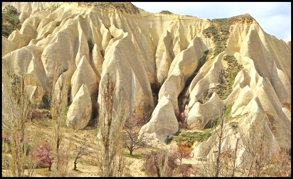
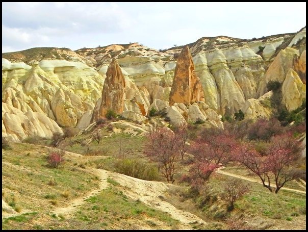
Given that the canyons are set so close together, even connected to one another, their great diversity is rather amazing. They vary in the shapes, colors and heights of their cliff walls, as well as their length, width and amount of vegetation. In addition, there are assorted rock pillars, pinnacles, tunnels and caves scattered throughout.
This makes hiking through every canyon and trail well worthwhile for avid hikers.
Most of the canyons are named by the color of the rock walls and, for some unknown reason, are referred to as ‘valley’s rather than ‘canyons’. By American standards, these are definitely canyons as they’re lined by rock cliffs. In any event, there’s Rose Valley, Red Valley, White Valley and Honey Valley.
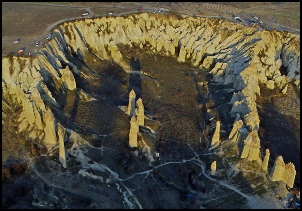
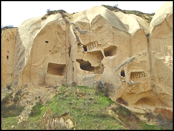
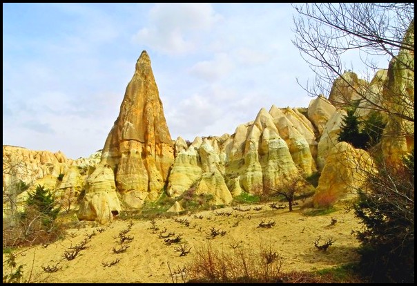
Other canyons are named by peculiarities found within, such as Sword Valley, Love Valley and Pidgeon Valley. Love Valley is politely named for the many penis-shaped rock pillars found there. Pidgeon Valley is full of historic petite man-made pidgeon roosting caves set high in the cliff walls, encouraging the birds to make homes there.
Other canyons have distinctly Turkish names, including Zemi, Meshkendir, Zelve, Pasabaglan and Zindanonu Valleys.
General Notes on the Hiking Trails
Goreme village is probably the best place for hikers to base themselves since it’s possible to start several hikes simply by walking out of town just10-15 minutes directly into one of the many canyons. Other hikes are more easily begun by taking a bus from Goreme, just 5-10 minutes out of town, in order to begin hiking closer to the canyon entry points.
But it’s also possible to walk to/from those start points along well-trafficked roads, adding an extra 3-4 km / 2.5 miles to the hike. Hitch-hiking to/from Goreme is also quite common, safe and easy, as buses don’t run very frequently and locals are happy to help out visitors.
As noted above, hiking trails run along the bottom of the canyons, on the ridgetops and on the eastern mesa massif. Some walks entail hiking into the canyon to its end and then returning back on the same trail, while other hikes can be done in loops. Most hikes are about 1 hour each way for the return trails and 2-3 hours for loop trails (longer if you hike the road in one direction rather than catching a ride).
I based myself in Goreme to hike for two weeks and I recommend Goreme as the best base for hiking. Therefore, the following descriptions start/end at Goreme.
It’s also possible to base oneself in Uchisar (next best choice), Ortasihar or Urgup. Obviously access to/from the various hikes will differ in those cases. I’m also told that there are many other canyons leading out from each of those towns, but whether there are marked hikes or not I don’t know.
Trails are marked occassionally, mostly by stone signs marking the entrance points of each canyon and/or trail. Having a copy of the great hiking map from Kamelya Hostel makes hiking life much, much easier. Since the trails are mainly outback walking trails, they’re not marked on Google maps, so forget using your phone to navigate.
Hiking Safety
Note that the parts of the canyons trails can be prone to flash flooding in sudden, heavy rain. The tunnels and narrow sections of canyons could prove dangerous in such conditions.
The two trails on Aktepe Hill could prove dangerous in rain, wind, storms or snow since they are completely exposed, with no place to take shelter.
Most times, however, Cappadocia offer bright blue skies and intense sun. Be careful not to burn your skin or get dehydrated. Use sunscreen and/or cover up, take plenty of water and use electrolytes (you can usually buy powered electrolytes / oral rehydration solution at pharmacies).
Consult the weather forcast in advance, plan hikes during good weather and take whatever gear, water and/or food you may need.
Pidgeon Valley Hikes
The most prominent (and most utilized) trail is through Pidgeon Valley, which runs southward from the edge of Goreme all the way to Uchisar, set high on a huge rock pinnacle, a distance of 4 km / 2.5 miles. To hike into Pidgeon Valley from Goreme, you simply have to walk about 10 minutes out of town to the large marked hiking sign and head into the canyon.
Hikers have several options for exploring this canyon system.
1. Hike to Uchisar village and back
2. Hike into Pidgeon Valley’s lesser-known eastern branch canyons and back
3. Combine the hike to/from Uchisar and the branch canyons
4. Loop trail through Pidgeon, Honey, White and Love Valleys & back to Goreme
1. Hike to Uchisar village and back
The main walking route through Pidgeon Valley runs between Goreme and Uchisar, a one-hour hike each way, with spectacular cliffs, wavy rock walls, a variety of rock pillars & formations, and thousands of the tiny pidgeon ‘caves’ set high up in the cliff walls. From about halfway through the canyon, the climb up to Uchisar becomes quite steep, particularly within the village itself.
The rewards include stunning panoramic views down into several canyons and out over the vast plain north of Goreme, as well as a visit to Uchisar’s main point of fame ‘Uchisar Castle’. The town’s tall central rock pillar was carved out with a series of caves thousands of years ago. There’s a flat look-out point on the very top. Exploring Uchisar Castle requires paying a modest entry fee.
Uchisar village is also quite interesting to explore, with its steep winding cobblestone roads, ever-changing panoramic views and upscale boutiques, specialty restaurants and boutiqe cave hotels.
The canyon hike between the two villages takes about one hour each way. Exploring Uchisar can take anywhere from 1-3 hours, depending on how much you want to explore. You can also stop for a drink and/or meal. So the total trip can easily make a half-day or even full-day trip.
2. Hike into Pidgeon Valley’s lesser-known eastern branch canyons and back
About halfway through Pidgeon Valley, at the point where the trail to Uchisar starts climbing, and where a currently-disused rustic cafe is situated, two lesser trails branch off to the east into two much smaller canyons that offer a series of tunnels to walk through, beautiful valleys with dense growths of flowers and fruit trees in summer months and, for those who can find them, two very tall trickling waterfalls.
From Goreme, it takes about 1-1.5 hours to explore these branch valleys and then about 30 minutes to return to Goreme.
3. Combine the hike to/from Uchisar and the branch canyons
Hikers who want a much longer walk can easily combine these two walks, making a half-day to full-day trip, depending on how long you spend in Uchisar village or exploring the beautiful canyons.
4. Loop trail through Pidgeon, Honey, White and Love Valleys & back to Goreme
Honey, White and Love Valleys are connected to each other (basically, they’re one long canyon with sections having different names). They are situated west of Goreme and Uchisar and are completely separate from Pidgeon Valley. They’re located west of the main north-south highway running between Nevsihar city – Uchisar – Goreme.
To make this loop hike from Goreme, first hike through Pidgeon Valley up to Uchisar. The trail comes out at the base of Uchisar village, on a steep cobblestone road that leads up into town from the main highway. At this point, there’s no need to walk up into town. Instead, take the cobblestone road downhill to the highway. Cross the highway, where Ozler Art Center is located, and walk back behind that building onto a dirt road.
This open road runs on top of a ridge, with canyons falling off to either side. Continue on the dirt ridge road about 200-300 M / yards, where there’s a Y in the road and a large sign pointing to the right-hand fork for ‘Love Valley’.
Continue on that dirt ridge road another 300-400 M / yards, where the trail unexpectedly drops steeply down on the left side into Honey Valley. There is a large stone sign marking the trail, but both the sign and trail can be a bit hard to locate. There are also two large metal boxes right near the descent point, which are used by vendors, who may or may not be there selling jewelry, fresh orange juice and/or other drinks.
The trail drops steeply down into the canyon for about 10 minutes, then levels out along the eastern (right) wall of the canyon, somewhat above the canyon floor for quite a distance, then eventually drops down to the bottom of the canyon.
The high walls of Honey Canyon are a deep rich golden color and formed into waves. Heading north, this canyon leads directly into White Canyon, where the high cliffs are suddenly milky white.
White Canyon, in turn, leads directly into Love Valley, which opens up much wider. The rather alarmingly-shaped rock pinnacles there are scattered along the western wall. Up above on the ridge to the west is a popular lookout point, accessed by road outside the valley.
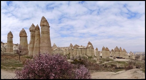
Love Valley, with its penis-shaped rock pillars, is one of Cappadocia’s main tourist spots, so from late morning through afternoon and evening, expect people – possibly crowds – to be looking down from the viewpoint, as well as wandering around the pillars.
From Love Valley, trails and a dirt road lead northward to the main E-W highway. It’s about a 10-minute walk. From there, take the highway east (right) another 5-minute walk to the main N-S road running between Goreme and Avanos.
It’s 3 km / 2.5 miles along this highway to Goreme. You can walk back beside the traffic, try waiting for the once-hourly bus, or hitchhike back to town.
The hike itself through the four valleys and on to the main road takes 2-3 hours. It’s another 40-60 minutes walk along the highway back to Goreme, or a 5-10 minute ride. Of course, the canyons are quite spectacular, so its well worth spending time gazing at all the rock formations & cliffs, taking photos and generally enjoying nature. Carry along a lunch and have a picnic immersed in nature.
If you prefer avoiding people while out in nature, plan to reach Love Valley in the early to mid morning. One way to do that is to hike this loop in reverse. First catch a bus or ride to the Love Valley turn off, then begin your hike from there, hiking southward from Love Valley through White Valley and Honey Valley. Then hike up out of Honey Valley onto the ridge and over to Uchisar then down into Pidgeon Valley to hike northward to Goreme.
Despite the popularity of Love Valley, very few people venture into Honey or White Valleys, so you’ll probably have those canyons all to yourself most times of the year.
Rose and Red Valley Region Hikes
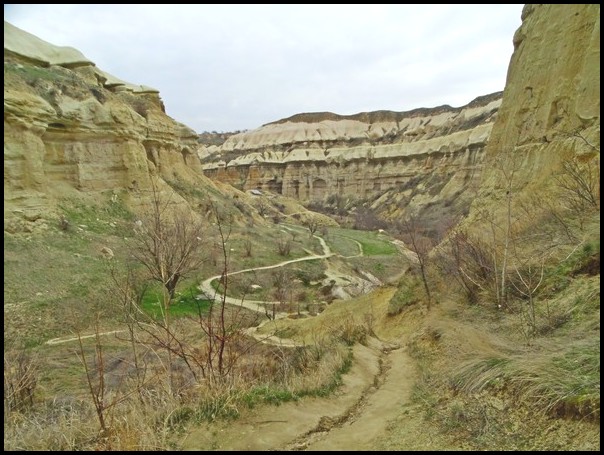
This vast region of interconnected canyons lies at the western base of Aktepe Hill and set on the east side of the wide plain running north-south between Goreme and distant Avanos town. The canyons all open into the wide plain between Goreme and Cavusin, with the end of the canyons butting up against the base of the huge mesa.
The canyons all run in a northwest-southeast direction and vary in length, width and rock colors. Several have a series of tunnels to walk through, while all have caves, cave churches, pidgeon ‘caves’ and a variety of rock pillars and other formations.
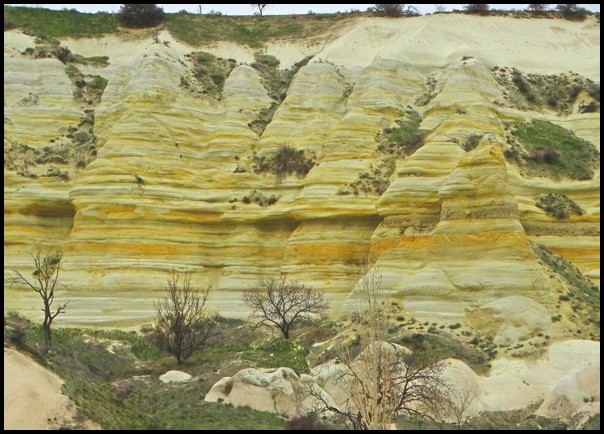
This is definitely one of the most exciting and beautiful regions to hike & explore. Rose Valley, in particular, is really spectacular, with one section boasting a near kaleidescope of rock colors, including shades of red, yellow, gold, green, gray, black and white rock. Zindanonu Canyon, at the far southern end nearest Goreme, offers the most exciting series of tunnels to hike through.
Hikers can explore one canyon per day, tackle 2-3 per day, or set out to explore them all in one full day of hiking.
To reach the canyon system from Goreme, catch a bus or a ride out to Kaya Camping, a 5-7 minute drive along the steep Urgup road heading east from Goreme.
At Kaya Camping, walk around their stone wall and head north on a dirt road. Within 10 minutes the road reaches a trail on the right that dips steeply down into Zindanonu Canyon. It’s less than 10 minutes down to the canyon floor, where the trail levels off and stays flat most of the way.
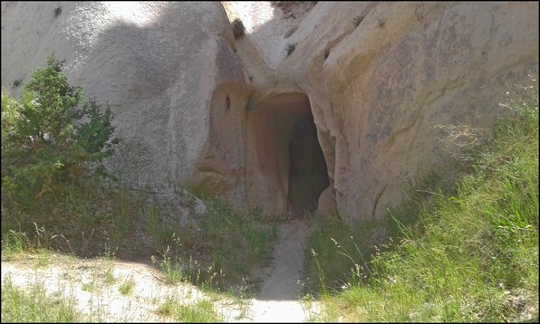
Soon you’ll reach a fork in the dirt roads with a sign pointing to Meskindir Canyon. If you’re interested, hike up into the rather minor canyon as a side hike and return. Else/then continue along the dirt road northward through Zindanonu Canyon, where you’ll soon walk through a series of large tunnels and pass a currently disused cave home.
Eventually you’ll reach another fork in the road and a sign pointing east (right) into Red Valley. Red Valley has some stunning cliffs, rock formations and variable rock colors, all ending at a spot surrounded by high red cliffs. En route you’ll hike through a tunnel that’s accessed by a tall metal ladder bolted to the rocks.
Near the end of the canyon a trail ascends to ridge trails that lead over to the top of Rose Valley and a couple of well-known cave churches. From there you can descend into Rose Valley to explore more stunning rock formations.
Alternately, you can hike back out of Red Valley the way to came then continue northward to access Rose Valley from its base.
When you’re finished exploring the canyons, return to the main dirt road and head north to Cavusin village. Otherwise you can return to Goreme by hiking up over a central ridge then across the wide plain southward to town.
If you explore all the side canyons, it will take 3-5 hours or more. On the otherhand, a straight walk to Cavusin without any side canyons is 4 km / 2.5 miles, about a one-hour walk.
From Cavusin you can catch a once hourly bus back to Goreme, hitch hike or walk4 km back to Goreme along the highway or along trails in the middle of the plain.
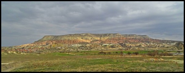
Aktepe Hill – aka ‘the mesa’ – Hikes
Aktepe Hill offers two great hiking trails, both starting from near Ortasihar village and ending at Cavusin village or nearby Zelve Canyon. One hike runs on the very top of the mesa while the other hugs the base of the mesa’s high cliffs way above the Red-Rose Canyon complex.
To access these two hikes, catch a bus or ride up to Ortasihar village highway bus stop, where the highway crosses a side road that leads to Aktepe Viewpoint. Of course you can also hike the 4 km/ 2.5 miles from Goreme to Ortasihar along the road, but be warned that’s it’s very steep and full of steady traffic.
From the Ortasihar highway bus stop/turn off, it’s 2 km along a paved side road to Aktepe Viewpoint, where both trails begin. You might be able to hitch hike the 2 km if you feel like it, though it’s a pleasant mostly-flat walk with stunning panoramic views and little traffic.
Aktepe Viewpoint offers spectacular panoramic views over the whole region, including Goreme, the Red & Rose Canyon system, Aktepe’s high cliffs, the huge plain running northward, the ridges above Honey-White-Love Canyon complex and beyond. At the viewpoint, a few open-air cafes offer drinks and snacks.
From there it’s easy to see the two trails. The Mesa Top trail runs 5 km to Cavusin village, while the lower trail is 4.5 km to Cavusin. At the northern end of each trail you can also opt to head east to Pasabaglan or Zelve Canyons, doubling the length of the hike.
1. Mesa Top Trail
The trail up to the top of the mesa runs steeply up to the right, then winds around a cliff and up to the top.
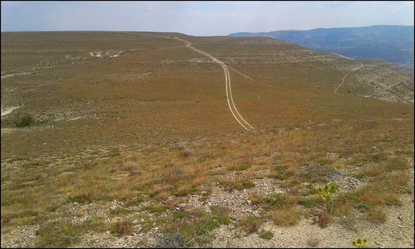
The mesa top consists of a very wide undulating field with the trail set smack in the middle. At the northern end the trail moves closer to the cliff tops, curves around the northern end of the mesa, then finally descends to a lower trail (though it’s still quite high up).
At that point, you can opt to head west (left) to Cavusin village, a 20-30 minute hike. Cavusin features a spectacular high rock formation, filled with multi-tiered cave homes. It’s called Cavusin Castle or Cavusin Church. The tiny village has a few restaurants, cafes and souvenir shops.
Alternately, you can take the much longer trail eastward (right) around the mesa to Pasabaglan Canyon or even further to Zelve Canyon. Pasabaglan has some stunning rock pillars and deep narrow canyons, while Zelve is a UNESCO World Heritage Site called Zelve Open Air Museum and is filled with impressive ancient cave churches.
It’s about 45 minute walk to the top of Pasabaglan Canyon and another 30-45 minutes on to Zelve Canyon. The trail stays quite high, hugging the side of the mesa.
At Pasabaglan Canyon, a tall wire fence surrounds the top of the canyon, separating the trail from the paid entrance area. A trail descends beside the fence to a road and then around to the canyon entrance. From there a once-hourly bus passes en route to Goreme via Cavusin. You can also walk 3 km to Cavusin.
If you continue on to Zelve Canyon, you’ll come across a similar situation with a final descent to the side of the canyon and paid entrance to explore the canyon’s treasures.
The same once-hourly bus passes through Zelve, returning to Goreme via Cavusin. From Zelve you can also hike the road 5 km to Cavusin village or 9 km all the way back to Goreme.
2. Aktepe Cliff-base Hike
This considerably more spectacular hike leads off to the left from Aktepe Viewpoint. The narrow trail hugs the base of Aktepe’s high stunning, multi-hued cliffs, yet still high above the Red-Rose Canyon complex.
This exciting trail allows hikers to walk right next to the impressive cliffs as well as peer down into the rugged winding canyons, all the while enjoying 180° panormic views over the vast plain below. It’s arguably the best hike in the region and my personal favorite.
Eventually, near the northern end of the vast mesa, the curving trail dips down onto a minor ridge just south of Cavusin village. From there a choice of trails gradually dips further down into the valleys, where you can walk into Cavusin or else hike around the northern end of the mesa to Pasabaglan and Zelve Canyons.
Most of this trail is very narrow, dusty and full of tiny stones (scree) and is set right on the edge, which drops steeply down into the canyons. Most of the trail is more or less level and about one foot wide, Math scrubby vegetation on both sides. However, in several spots the trail has eroded so that it slopes downward at the same angle as the hillside, with no vegetation to hope to break a slide. Be very careful not to slip and fall on this dusty, gravelly trail.
It’s also a good idea to avoid getting caught on either of these mesa trails in rain, snow or wind since the trails are completely exposed, with nowhere to take shelter. The mesa top trail could be especially dangerous in lightening storms, while the cliff-base trail could be especially dangerous in rain, snow or heavy wind. Consult the weather forecast beforehand and choose your hiking days carefully.
Other Canyon Hikes
From Goreme you can walk eastward out of town about 10-15 minutes along the road to Urgup to access two other minor canyon hikes.
1. Zemi Valley
On the south side of the road (right) is Zemi Valley, with a historic cave church and a 6-km / 3.5 mile trail.
This hike starts on a dirt road then leads to a narrow trail. This is not the most spectacular canyon, nor the nicest trail, but it’s another option for an easy-access hike.
Quite unfortunately, the trail often follows a shallow stream and boggy grassland. If it’s been raining, many sections are very muddy. So expect your shoes to get wet and muddy.
In addition, the trail is not well maintained. Thorn bushes, vines and tree branches overhang the trail, so you’re bound to get scratched unless completely covered, and you’ll have to constantly stoop, bend and wend your way along.
Zemi Valley might appear on paper to be an easy stroll, but it can actually be rather tiring and gritty. Go for it if you enjoy such hikes.
2. Sword Valley
On the road just beyond the entrance to Zemi Valley is a sign pointing to Sword Valley. It’s on the north / left side of the road, where a dirt road/ATV route heads north across an open plain.
Hike about 1 km north to a dirt road intersection. From there turn east/right and follow the road over to Sword Valley. A hiking trail leads southward into the canyon, which narrows and passes through several tunnels. It eventually climbs up onto the ridge and meets the highway to Urgup. From there hike back along the road to Goreme.
Alternatively, when you reach the end of the canyon, turn around and head back the way to came to Goreme.
========================
You might also like:
Introduction to Amazing Cappadocia
My First Hot Air Balloon Ride
========================


 Hi! I'm Lash, an American nomadic world traveler who's been traveling solo since 1998. I’m passionate about traveling the world nomadically and then sharing it all with you. I hope to inspire you to travel the world, to entertain you with tales from the road, and to help you reach your travel dreams. Welcome!