US7739038B2 - Methods and apparatus for geo-collaboration - Google Patents
Methods and apparatus for geo-collaboration Download PDFInfo
- Publication number
- US7739038B2 US7739038B2 US11/304,217 US30421705A US7739038B2 US 7739038 B2 US7739038 B2 US 7739038B2 US 30421705 A US30421705 A US 30421705A US 7739038 B2 US7739038 B2 US 7739038B2
- Authority
- US
- United States
- Prior art keywords
- map
- computer
- user selected
- geographical location
- map file
- Prior art date
- Legal status (The legal status is an assumption and is not a legal conclusion. Google has not performed a legal analysis and makes no representation as to the accuracy of the status listed.)
- Active, expires
Links
Images


Classifications
-
- H—ELECTRICITY
- H04—ELECTRIC COMMUNICATION TECHNIQUE
- H04L—TRANSMISSION OF DIGITAL INFORMATION, e.g. TELEGRAPHIC COMMUNICATION
- H04L67/00—Network arrangements or protocols for supporting network services or applications
- H04L67/50—Network services
- H04L67/52—Network services specially adapted for the location of the user terminal
-
- G—PHYSICS
- G09—EDUCATION; CRYPTOGRAPHY; DISPLAY; ADVERTISING; SEALS
- G09B—EDUCATIONAL OR DEMONSTRATION APPLIANCES; APPLIANCES FOR TEACHING, OR COMMUNICATING WITH, THE BLIND, DEAF OR MUTE; MODELS; PLANETARIA; GLOBES; MAPS; DIAGRAMS
- G09B29/00—Maps; Plans; Charts; Diagrams, e.g. route diagram
- G09B29/10—Map spot or coordinate position indicators; Map reading aids
-
- H—ELECTRICITY
- H04—ELECTRIC COMMUNICATION TECHNIQUE
- H04L—TRANSMISSION OF DIGITAL INFORMATION, e.g. TELEGRAPHIC COMMUNICATION
- H04L51/00—User-to-user messaging in packet-switching networks, transmitted according to store-and-forward or real-time protocols, e.g. e-mail
- H04L51/21—Monitoring or handling of messages
- H04L51/222—Monitoring or handling of messages using geographical location information, e.g. messages transmitted or received in proximity of a certain spot or area
-
- H—ELECTRICITY
- H04—ELECTRIC COMMUNICATION TECHNIQUE
- H04L—TRANSMISSION OF DIGITAL INFORMATION, e.g. TELEGRAPHIC COMMUNICATION
- H04L67/00—Network arrangements or protocols for supporting network services or applications
- H04L67/01—Protocols
- H04L67/10—Protocols in which an application is distributed across nodes in the network
-
- H—ELECTRICITY
- H04—ELECTRIC COMMUNICATION TECHNIQUE
- H04W—WIRELESS COMMUNICATION NETWORKS
- H04W4/00—Services specially adapted for wireless communication networks; Facilities therefor
- H04W4/02—Services making use of location information
- H04W4/023—Services making use of location information using mutual or relative location information between multiple location based services [LBS] targets or of distance thresholds
-
- H—ELECTRICITY
- H04—ELECTRIC COMMUNICATION TECHNIQUE
- H04W—WIRELESS COMMUNICATION NETWORKS
- H04W64/00—Locating users or terminals or network equipment for network management purposes, e.g. mobility management
-
- H—ELECTRICITY
- H04—ELECTRIC COMMUNICATION TECHNIQUE
- H04L—TRANSMISSION OF DIGITAL INFORMATION, e.g. TELEGRAPHIC COMMUNICATION
- H04L67/00—Network arrangements or protocols for supporting network services or applications
- H04L67/01—Protocols
Definitions
- the present invention relates generally to methods and apparatus for collaborative usage of geographical information, and more particularly, to advantageous techniques for combining geographical information systems with collaborative systems to achieve advantageous map features between users of two or more computers.
- GIS Geographical information systems
- ESRI Environmental Systems Research Institute's
- a computerized map file such as Environmental Systems Research Institute's (ESRI) geodatabase file format, comprises one or more layers of geographical information which, when rendered together on a computer screen, shows a user a cognizable map.
- Each layer may provide different information relating to geography or contain geospatial information such as statistical, demographic, and other like information relating to the geography.
- a world map may have five or more layers.
- One layer may include geographical information to render the borders of the world's continents.
- a second layer may include geographical information to render the borders of the world's countries.
- a third layer may include geographical information to render the borders of states in a country.
- a fourth layer may include geographical information to render the borders of counties in a state.
- a fifth layer may include geographical information to render the borders of cities within the counties.
- Other layers may include population distributions, school districts, locations of government offices, and the like.
- Collaborative software is application software that integrates work on a single project by several concurrent users at separated workstations. In its modern form, it was pioneered by Lotus Software with the popular Lotus Notes application running in connection with a Lotus Domino server. Collaborative software allow participants to have collaborative interactions which allow participants to alter a collaboration entity such as a document or other common deliverable. Typically, collaborative software applications are limited to allowing users to jointly edit a document, a presentation, a spreadsheet, or other flat file. Collaborative software applications may provide a virtual repository which allows data to be replicated, stored, and synchronized on multiple computers operating in a peer-to-peer relationship. A member of a virtual repository is a user who has been assigned and given permission to share information in the virtual repository. For example, Groove® Virtual Office provides a concept called a “workspace” which allows users, who have been assigned to the same workspace, to share and synchronize files which have been added to the workspace.
- Computerized maps may contain voluminous and complex information. Rather than merely revealing magnified information when zooming in on documents, presentations, spreadsheets, when a user zooms in on a computerized map, additional information is revealed to the user. For example, a user viewing the map of the United States may see the borders of each state and the country's borders. However, when the user zooms into a particular city street, the viewer may render points of interest to the user such as particular stores, gas stations, parks, and the like. Additionally, a user may scroll a map, for example of the world, which has no defined beginning or end. Consequently, a map file has to contain a lot of information that may or may not be rendered depending on a user's interaction with a map.
- the present invention addresses problems such as those described above and brings together the core functions of collaborative software applications with those of GIS to provide a collaborative framework based on maps and location.
- Another aspect of the present invention provides computer users with the ability to share, independently of their respective location, maps and geospatial information overlaid on maps.
- Another aspect of the present invention called decentralized data updating in synchronous and asynchronous modes, provides users with the ability to work with geospatial information while connected or disconnected from other collaborators.
- Another aspect of the present invention called asymmetrical information management, provides users with the ability to choose to share all or portions of their own geospatial information with other users.
- Methods and computer readable medium for collaborating on geographical maps between two or more computers are disclosed.
- techniques for sharing a geographical location on a map between two or more computers and co-navigating a map between two or more computers are disclosed.
- the geographical location is retrieved to the first computer.
- the geographical location is added to the map being rendered at the first computer and is sent to a second computer.
- a map including the geographical location is rendered at the second computer.
- a map is displayed from a map perspective at the first computer.
- the map perspective is sent to the second computer.
- a map from the same map perspective being displayed at the first computer is rendered at the second computer.
- FIG. 1 shows an illustrative system employing a geo-collaboration system in a stand alone environment in accordance with the present invention.
- FIG. 2 shows an illustrative network environment employing geo-collaboration system in accordance with the present invention.
- FIG. 3A shows an exemplary main screen for geo-collaboration software in accordance with the present invention.
- FIG. 3B shows a map of New La, La. being rendered by geo-collaboration software at computer 112 A in accordance with the present invention.
- FIG. 3C shows a map of Slidell, La. being rendered by the geo-collaboration software at computer 112 B in accordance with the present invention.
- FIG. 3D shows a map of New La and Slidell being rendered by the geo-collaboration software at computer 112 C in accordance with the present invention.
- FIG. 3E shows a view perspective of a map of New La and Slidell being rendered by the geo-collaboration software at computer 112 C before acting as a leader in accordance with the present invention.
- FIG. 3F shows a view perspective of a map of New La, La. being rendered by the geo-collaboration software at computer 112 A before acting as a follower in accordance with the present invention.
- FIG. 3G shows a view perspective of a map of Slidell, La. being rendered by the geo-collaboration software at computer 112 B before acting as a follower in accordance with the present invention.
- FIG. 3H shows a view perspective of a map of New La' and Slidell being rendered by the geo-collaboration software at computer 112 C while acting as a leader in accordance with the present invention.
- FIG. 3I shows a view perspective of a map of New La, La. being rendered by the geo-collaboration software at computer 112 A while acting as a follower in accordance with the present invention.
- FIG. 3J shows a view perspective of a map of Slidell, La. being rendered by the geo-collaboration software at computer 112 B while acting as a follower in accordance with the present invention.
- FIG. 3L shows a map with a plotted icon according to the inputted address of FIG. 3K .
- FIG. 4 shows a block diagram of a portion of geo-collaboration software which addresses layer management and map item management between computers in accordance with the present invention.
- FIG. 5 shows a calling sequence illustrating the interactions of the software class instances of FIG. 4 for adding and removing map layers.
- FIG. 6 shows a calling sequence illustrating the interaction of the software objects of FIG. 4 for adding items to a map.
- FIG. 7 shows a block diagram of a portion of geo-collaboration software which addresses co-navigating a map shared between two or more computers in accordance with the present invention.
- FIG. 8 shows a calling sequence illustrating the interactions of the software class instances of FIG. 7 for co-navigating a map.
- FIG. 9 shows a block diagram of a portion of geo-collaboration software which addresses location awareness on a map shared between two or more computers in accordance with the present invention.
- FIG. 10 shows a calling sequence illustrating the interactions of the software class instances of FIG. 9 for sharing a location retrieved from a GPS system of a person or item on a map shared between two or more computers.
- FIG. 11 is a flow chart of a method for synchronizing map layers between two or more computers according to the present invention.
- FIG. 12 is a flow chart of a method for sharing a map item between two or more computers according to the present invention.
- FIG. 13 is a flow chart of a method for co-navigating a map shared by two or more computers according to the present invention.
- the present invention may be embodied as methods, systems, or computer program products. Accordingly, the present invention may take the form of a hardware embodiment, a software embodiment or an embodiment combining software and hardware aspects. Furthermore, the present invention may take the form of a computer program product on a computer-usable storage medium having computer-usable program code embodied in the medium. Any suitable computer readable medium may be utilized including hard disks, CD-ROMs, optical storage devices, flash memories, or magnetic storage devices.
- FIG. 1 shows a diagram of a system 100 employing a geo-collaboration system in a stand-alone environment accordance with the present invention.
- the illustrated system 100 is implemented as a stand-alone personal computer or workstation 112 .
- system 100 includes geo-collaboration software 130 in accordance with the present invention which is stored in memory and run by the central processing unit of the personal computer 112 .
- the presently preferred geo-collaboration software 130 is embodied in a software product known as Toucan Navigate.
- System 100 also includes collaboration software 140 such as Groove® Virtual Office which is also stored in memory and run by the central processing unit of the personal computer 112 .
- the collaboration software 140 is responsible for synchronizing data on a peer-to-peer basis between two or more computers. For example, if a document is shared between two computers, each computer has a copy of the document and the collaboration software is responsible for synchronizing the latest updates to the document to each respective copy.
- the present invention has been implemented using Groove® Virtual Office, it should be noted that the use of other collaboration software applications which can synchronize data between two or more computers is contemplated by the present invention.
- the computer 112 includes a number of standard input and output devices, including a keyboard 114 , mouse 116 , CD-ROM drive 118 , disk drive 120 , and monitor 122 .
- the computer 112 includes an Internet or network connection 126 for downloading software, data, and updates. It will be appreciated, in light of the present description of the invention, that the present invention may be practiced in any of a number of different computing environments without departing from the scope of the invention.
- the system 100 may be implemented in a network configuration with individual workstations connected to a server.
- other input and output devices such as laptops, handheld devices, or cell phones, for example, may be used, as desired.
- One embodiment of the invention has been designed for use on a stand-alone personal computer, laptop, or workstation on an Intel Pentium or later processor, using as an operating system Windows XP, Windows NT, or the like.
- the geo-collaboration software 130 in accordance with the present invention may be used to add and remove layers of a map, to add and remove geographical objects to a layer or layers, and to add and remove a location to a map. These functions are described in further detail in connection with FIGS. 4-6 .
- a layer may be static or dynamic.
- a static layer contains well-known geography such as roads, county borders, all the locations of McDonalds in Texas, and the like.
- a dynamic layer contains map objects which are created in response to information coming from a remote data source or added by an individual user.
- One remote data source for example, is the National Office of Aeronautics which provides a severe weather warning feed of information.
- Geographical objects may be added to a static or dynamic layer. Exemplary geographical objects include a point, a line, a 2-dimensional shape, a 3-dimensional shape, a graphic, and the like.
- FIG. 2 shows an illustrative network environment 200 employing geo-collaboration system in accordance with the present invention.
- the network environment 200 includes three computers 112 A- 112 C and a network 220 .
- the network 220 may include any local area network, wide area network, Internet, some combination of network connections, or the like.
- the network environment 200 may suitably include wired and wireless connections.
- Computers 112 A- 112 C operate in a peer-to-peer relationship.
- Computers 112 A- 112 C execute geo-collaboration software 130 in accordance with the present invention and collaboration software application 140 .
- FIG. 2 shows three computers 112 A- 112 C, geo-collaboration features involving the sharing of geo-spatial information achieved by geo-collaboration software 130 according to the teachings of the present invention may include two or more computers.
- a map or a layer of a map is modified on computer 112 A while in the stand alone environment as illustrated in FIG. 1 , all of the modifications to the map and layer which are shared with other users are synchronized once computer 112 A is connected to network 220 . While computers 112 A- 112 C are connected over a network and modifications are made to a map or a layer of a map, a modification made on computer 112 A becomes viewable on computers 112 B and 112 C and vice versa as long as the map or layer of the map containing the modification is shared between the computers. Further exemplary details of how modifications are shared will be described in connection with FIGS. 4 and 5 .
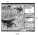
- FIG. 3A shows the main user interface screen 300 of the geo-collaboration software 130 in accordance with the present invention.
- the main screen 300 includes a map viewer 310 .
- the map viewer 310 includes a map toolbar 320 , a map item pane 340 , a layers pane 350 , a co-navigate pane 360 , and a team location pane 370 . Each of these panes provides access to geo-collaboration features implemented by geo-collaboration software 130 .
- the map viewer 310 renders an exemplary map 330 of the Earth. It should be noted that the shading shown in FIGS. 3A-3L represent various colors displayed on a computer screen.
- the map item pane 340 displays the current location of pointing device or cursor 347 on the rendered map 330 . As shown, the map item pane 340 displays that the present cursor 347 is at rest at longitude ⁇ 86.027523° and the latitude is 39.291227°.
- the map item pane 340 may also display attributes associated with a particular location being pointed to by a pointing device, interacting with a global positioning system (GPS) device, or the like. For example, if the pointing device points to a location which has been assigned other attributes like an address, a telephone number, names, or the like, those attributes would also be displayed in the map item pane 340 .
- GPS global positioning system
- the layers pane 350 provides a user the capability to manage layers that compose the rendered map 330 .
- the map viewer 310 aggregates and renders all the loaded layers of a map as indicated in the layers pane 350 .
- the map view 310 renders layers named “countries” and “incidents” to compose the map 330 .
- a map layer may comprise colored symbols, labels, shapes defined by one or more persons which are replicated to other related computers.
- a layer may be added from the file system accessible by the processor executing the geo-collaboration software application 130 or a shared virtual repository such as a workspace. The added layer is then rendered by the map viewer 310 and overlaid on map 330 .
- the map viewer 310 was being executed by computer 112 A and that the layer was retrieved from computer 112 A's file system, the added layer would only be visible on computer 112 A.
- the map viewers executing on computers 112 B and 112 C would display the layer added by computer 112 A.
- This feature of managing layers of a map is called decentralized geographical data update because any member may add a layer of a map to be shared or not depending on whether the layer has been added to the shared virtual repository.
- Toolbar 320 provides tools including a tool for managing a layer.
- the “Add” drop down provides a user to add incidents such as points, lines, areas, and other objects to a layer of map 330 .
- incidents such as points, lines, areas, and other objects to a layer of map 330 .
- the user at computer 112 A adds a new layer as described in further detail in connection with FIG. 5
- the user can add incidents to the map layer and if the map layer is taken from or added to a shared virtual repository, those added incidents are then rendered by map viewers executing on computers 112 B and 112 C.
- Exemplary geo-collaboration features include asymmetric geographical information management, co-navigation, team location presence and awareness, and decentralized geographical data updates.
- the asymmetric geographical information management, co-navigation, and team location presence and awareness features will be discussed further below in order by showing a visible representation of the features. A discussion of the internal software components of the geo-collaboration software application 130 to achieve the features will then follow.
- FIGS. 3B-3D show portions of maps being shared between users at computers 112 A- 112 C respectively to illustrate the feature entitled geo-visualization.
- the user of computer 112 A is a member of a virtual repository called “New Orleans Power Outage.”
- the user of computer 112 B is a member of a virtual repository called “Slidell Power Outage.”
- the user of computer 112 C is a member of both virtual repositories.
- the user of computer 112 A may be a relief manager responsible for New Louisiana
- the user of computer 112 B may be a relief manager responsible for Slidell
- the user of computer 112 C may be the manager responsible for the entire state of Louisiana.
- FIG. 3B shows a map 311 of New La, La. being rendered by the geo-collaboration software 130 at computer 112 A in accordance with the present invention.
- the map viewer 310 renders a certain set of map layers. Referring to layer pane 312 , these rendered layers include Power Off—New Louisiana, Incidents, highways, state capitals, states, lakes, rivers, and Louisiana roads. How these layers are added to other computers, edited, and removed in order to be presented across multiple computers will be described in further detail in connection with discussion of FIG. 5 .
- the Power Off—New La layer is illustrated by the display icons 313 A- 313 C which represents locations in New La where the power is off.
- Map item pane 314 displays information related to the power off location map item 313 C. This information is displayed when a pointing device hovers or clicks on an icon of interest. Adding, updating, and deleting map item information according to the present invention across multiple machines is discussed in further detail in connection with FIG. 6 .
- a map item when rendered in a map may be a location, a point, a line, a shape, an icon, or the like.
- FIG. 3C shows a map 321 of Slidell, La. being rendered by the geo-collaboration software 130 at computer 112 B in accordance with the present invention.
- the map viewer 310 renders a certain set of map layers. Referring to layer pane 322 , these rendered layers include Power Off—Slidell, incidents, highways, state capitals, states, lakes, rivers, and Louisiana roads.
- the Power Off—Slidell layer is illustrated by the display icons 323 A- 323 C which represents locations in Slidell where the power is off. Since a pointing device 325 is over location 323 C, map item 324 displays information related to the power off status at location 323 C.
- FIG. 3D shows a map 331 of New La and Slidell being rendered by the geo-collaboration software 130 at computer 112 C in accordance with the present invention.
- the layer pane 332 contains both the Power off—Slidell and Power Off—New La layers.
- the map viewer 330 renders icons 313 A- 313 C which represent locations in New Louisiana where the power is off and icons 323 A- 323 C which represent locations in Slidell where the power is off.
- the utility manager responsible for the entire state of Louisiana utilizing computer 112 C has view or map perspective of power outages commensurate with his or her area of responsibility.
- the additional points of interest will be automatically rendered at substantially the same time at all the computers.
- the idea of substantially the same time as used herein includes any delays in transmitting information through a network. If, for example, computer 112 A was not communicating with the network 220 at the time the manager added the additional points of interest, computer 112 A will render the additional points of interest once the computer 112 A communicates over the network 220 . If, for example, the manager added the additional points of interest while computer 112 C was not communicating with the network 220 , the additional points of interest will be rendered at computers 112 A and 112 B after computer 112 C begins communicating with network 220 . How the geo-collaboration software 130 provides updates between computers is addressed further in connection with the discussion of FIG. 5 .
- FIGS. 3E-3J illustrate the co-navigation feature of geo-collaboration software 130 in accordance with the present invention.
- Co-navigation provides users of a shared virtual repository located at various locations to have the same view perspective of a map as one of the users, called the leader.
- the leader establishes the view perspective and shares that view perspective with the other users of the virtual repository, called followers.
- FIGS. 3E-3G are map perspectives being automatically rendered at substantially the same time at computers 112 C, 112 A, and 112 B, respectively, before the co-navigation feature is invoked.
- FIGS. 3H-3J are map perspectives being automatically rendered at substantially the same time at computers 112 C (leader), 112 A (first follower), and 112 B (second follower), respectively, while the co-navigation feature is invoked.
- FIG. 3E shows a view perspective 353 of a map of New La and Slidell being rendered by the geo-collaboration software at computer 112 C before that computer begins acting as a leader in accordance with the present invention.
- the view perspective 353 includes an altitude indicator 352 indicating that view perspective 353 is from an altitude of 78 miles above sea level.
- the user at computer 112 C is informed that he or she is not participating in a co-navigation session by the “neither” button being selected.
- FIG. 3F shows a view perspective 354 of a map of New La, La. being rendered by the geo-collaboration software 130 at computer 112 A before that computer begins acting as a follower in accordance with the present invention.
- the view perspective 354 includes an altitude indicator 355 indicating that view perspective 354 is from an altitude of 20 miles above sea level.
- FIG. 3G shows a view perspective 356 of a map of Slidell, La. being rendered by the geo-collaboration software 130 at computer 112 B before that computer begins acting as a follower in accordance with the present invention.
- the view perspective 356 includes an altitude indicator 357 indicating that view perspective 356 is from an altitude of 10 miles above sea level.
- FIGS. 3H-3J are map perspectives being automatically rendered at substantially the same time at computers 112 C, 112 A, and 112 B, respectively, while the co-navigation feature is invoked.
- FIG. 3H shows a view perspective 358 of a map of New La and Slidell being rendered by the geo-collaboration software 130 at computer 112 C while acting as a leader in accordance with the present invention.
- the user of computer 112 C has invoked the co-navigation feature by selecting the lead button 341 .
- the user of computer 112 C has zoomed in to a bridge accident.
- Indicator 359 indicates that the view perspective 358 is from an altitude of 34 miles. For purposes of this example, it is assumed users at computers 112 A and 112 B have joined the co-navigation session.
- FIG. 3I shows a view perspective 342 of a map of New La, La. being rendered by the geo-collaboration software 130 at computer 112 A while acting as a follower in accordance with the present invention.
- the follow button 343 selection indicates that the user of computer 112 A has requested and has now joined the co-navigation session with computer 112 C.
- View perspective 342 has an altitude indicator 344 indicating that the view perspective 342 is from an altitude of 34 miles, equivalent to view perspective 358 . While in the co-navigation session, wherever the user of computer 112 C moves his or her map perspective, the user of computer 112 A will automatically view his or her map from the same map perspective being viewed at computer 112 C.
- New La. Power Outage virtual repository contains the layer incidents 345 which include the map item 346 indicting a bridge accident. Consequently, the user of computer 112 A may view the bridge accident 347 in view perspective 342 .
- FIG. 3J shows a view perspective 348 of a map of Slidell, La. being rendered by the geo-collaboration software 130 at computer 112 B while acting as a follower in accordance with the present invention.
- the selection of follow button 333 indicates that the user of computer 112 B has also joined the co-navigation session with computers 112 A and 112 C as a follower.
- geo-collaboration software 130 of computer 112 B renders his or her map from the same view perspective of computer 112 C. Consequently, view perspective 348 contains an altitude indicator 349 indicating that the view perspective is from an altitude of 34 miles, the same view perspective of FIG. 3H rendered at computer 112 C.
- the geo-collaboration software 130 supports various techniques for plotting and sharing the location of a user to a map. For example, a user of geo-collaboration software 130 may click with a pointing device on a map, may input a specific address, or may specify a particular vCard to indicate his or her location. A vCard is an Internet standard for creating and sharing virtual business cards. Additionally, geo-collaboration software 130 may interface to a global positioning system (GPS) and plot the corresponding GPS coordinates onto a shared map.
- GPS global positioning system
- FIG. 3K shows a pop-up screen 334 for plotting and sharing an icon corresponding to an inputted address in accordance with the present invention.
- the geo-collaboration software 130 retrieves geographical coordinates corresponding to the address and plots an icon onto a map according to the retrieved geographical coordinates.
- the user of computer 112 C may be wirelessly connected to network 220 and located in a utility truck 104 . The user would input his or her current Slidell address into pop-up screen 334 and would click the Find button.
- FIG. 3L shows a map 335 with a plotted icon 336 according to the inputted address of FIG. 3K . Since the user of computer 112 C is a member of both the New La Power Outage and the Slidell Power Outage virtual repositories, the plotted icon 336 will be rendered by geo-collaboration software 130 running on computers 112 A and 112 B and, thus, shared with users of computers 112 A and 112 B. It should be noted that the icon of truck 206 of map 335 has had its location plotted from interfacing with a GPS. Further detail of how this location awareness feature is achieved is addressed in connection with the discussion of FIGS. 9 and 10 .
- FIG. 4 shows a block diagram 400 of a portion of geo-collaboration software which performs layer management and map item management between computers in accordance with the present invention.
- the block diagram 400 shows software classes 410 - 470 which, when instantiated, interact which each other to accomplish decentralized geographical data updates.
- the user interface class 410 is responsible for showing the current state of the geo-collaboration software application 130 to the user and acting as a means with which the user can modify map data and map layers.
- the map controller class 420 is responsible for coordinating the other class instances that make up the geo-collaboration software application 130 .
- LayerStore class 430 encapsulates any persistent storage such as a hard drive, file directory, web service, or database used to map data.
- MapItem class 460 represents a point, lines including roads, shapes, and other data constructs with a geographic element such as observations or location reports.
- MapLayer class 470 may contain one or more MapItems that share a common set of characteristics such as display properties.
- Map class 440 is responsible for the display of MapItem class instances and MapLayer class instances.
- PropertyReplicator class 450 is responsible for asynchronously disseminating the definitions of MapItem and MapLayer instances to other computers executing geo-collaboration software 130 .
- MapItems and MapLayers may be encoded in extended markup language (XML), binary objects, serial objects, or any other suitable format. The operations of these classes will be further described in connection with FIGS. 5 and 6 . It should be noted that in this context the terms class instance or object mean an instantiation in memory of a corresponding class during run time of the geo-collaboration software 130 .
- FIG. 5 shows a calling sequence 500 illustrating the interactions of the software class instances of FIG. 4 for adding and removing map layers in the geo-collaboration software 130 .
- the method calls 510 , 520 , 530 , 540 , 550 , 560 , 570 , 580 , and 590 are executed by a computer, such as computer 112 A running geo-collaboration software 130 .
- Method calls 512 and 522 are executed by computer 112 A and any other computers such as computers 112 B and 112 C running geo-collaboration software 130 whose users are members of the same virtual repository.
- a user of geo-collaboration software 130 executing on computer 112 A wanting to share a map layer containing his or her favorite bicycle training routes through the city with users at computers 112 B and 112 C is an example of when the sequence of method calls 510 , 520 , 530 , 540 , 550 , 560 , 570 , 580 , and 590 are executed. Or, as described above, the manager responsible for addressing power outages in the state of Louisiana may want to report locations of utility service personnel to other coworkers.
- To add the map layer to a map a user selects the “Add” pull down menu accessible from toolbar 320 . Upon clicking on the add feature, the AddMapLayer( ) method 510 on the User Interface class 410 is called.
- AddMapLayer( ) method 510 then calls AddMapLayer( ) method 520 on the Map Controller class 420 .
- the AddMapLayer( ) method 520 calls the LocateMapLayers( ) method 530 on the LayerStore class 430 and retrieves map layers accessible through the repository encapsulated by the LayerStore class 430 .
- the PresentMapLayerSelection( ) method 535 returns the retrieved map layers and their associated metadata including their position to the user.
- these selectable layers may be presented through the layers pane 350 .
- the user selects one or more map layers to be added to the shared map and, thus, to be aggregated by the map viewer 310 .
- the SelectLayers( ) method 540 is called on the User Interface class 410 .
- the SelectLayers( ) method 540 calls the SelectLayers( ) method 550 on the Map Controller class 420 .
- the SelectLayers( ) method 550 calls the RetrieveLayer( ) method 560 on the LayerStore class 430 , the AddLayer( ) method 570 on the Map class 440 and the SetLayerMetaData( ) method 580 on the PropertyReplicator class 450 .
- the RetrieveLayer( ) method 560 retrieves the selected layer from the LayerStore 430 , saves the selected layer and associated metadata and configuration and data files to the local computer 112 A.
- Metadata for a layer describes characteristics of the layer such as the layer's name, whether it is visible, what display styles it contains, and the like.
- An exemplary layer style may include information to render all point map objects on a layer with the true type font symbol for an airport using red 22 point type.
- the AddLayer( ) method 570 adds the selected layer and the associated metadata and configuration and data files to the Map class 440 instance.
- the create( ) method 575 creates a new map layer and returns the select layer's XML or other binary or serial representation of the layer to the MapLayer class 470 .
- the LayerMetaDataXML( ) method 577 returns the selected layer's XML to the Map Controller class 420 which in turn returns the selected layer's XML to the User Interface class 410 at time 579 .
- the Map Controller class 420 then calls the SetLayerMetaData( ) method 580 on the PropertyReplicator class 450 .
- the SetLayerMetaData( ) method 580 updates the PropertyReplicator class 450 with the selected layer's XML data and disseminates the selected layer's XML data to other members running the geo-collaboration software 130 .
- the PropertyReplicator class 450 interfaces with collaboration software 140 in order for collaboration software 140 to synchronize information such as the selected layer's XML data between computers 112 A- 112 C.
- the SetLayerMetaData( ) method 580 communicates with the PropertyReplicator Class 450 on computers running geo-collaboration software 130 which share the same virtual repository.
- the PropertyReplicator Class 450 executing on computer 112 A communicates the selected layer's XML data with the PropertyReplicator Classes executing on computers 112 B- 112 C, since the users of computers 112 B and 112 C are members of the same virtual repository.
- the sequence of calls to RetrieveLayer( ) method 560 , AddLayer( ) method 570 , creates method 575 , LayerMetaDataXML( ) method 577 , and SetLayerMetaData( ) method 580 are made for each layer selected by the user.
- the PropertyReplicator class 450 temporarily stores or buffers the selected layer's XML data until computer 112 A begins communicating with network 220 .
- the PropertyReplicator class 450 transmits the buffered information to collaboration software 140 once computer 112 A communicates with network 220 .
- an additional computer may be used to act as a mailbox for offline users.
- the PropertyReplicator class 450 transmits the information to the additional computer so that the offline computer can retrieve the updates once it connects to the network.
- the SetLayerMetaData( ) method 580 asynchronously calls the SetLayerMetaData( ) method 590 on computers 112 B and 112 C to communicate XML data describing the selected layer.
- the SetLayerMetaData( ) method 590 on computers 112 A- 112 C updates the selected layer in XML format on the respective machines.
- the SetLayerMetaData( ) method 590 on computers 112 A- 112 C communicate the XML data describing the selected layer with their respective map controllers by calling the SetLayerMetaData( ) method 512 on the Map Controller class 420 on computers 112 A- 112 C.
- the Map Controller class 420 on each of computers 112 A- 112 C determines whether the selected layer is available and whether a layer file corresponding to the XML data has been added to the map. If the corresponding layer file is not available, the SetLayerMetaData( ) method 512 does nothing. If the corresponding layer file is available, but has yet to be added to the map, the SetLayerMetaData( ) method 512 adds the corresponding layer file to the map. If the corresponding layer file has been added to the map, the SetLayerMetaData( ) method 512 running on each computer updates the corresponding layer file with the received XML data by calling its respective SetLayerMetaData( ) method 522 on its respective Map class 440 . Once updated, map viewer 310 on computers 112 A- 112 C will render the updated map on computers 112 A- 112 C.
- the methods 532 , 542 , 552 , 553 , and 562 of the sequence diagram 500 describe an example of a user updating the contents of a particular map layer.
- a user of computer 112 A wants to add his or her personal location to a map layer and have that personal location shared with users at computer 112 B and 112 C.
- the user interacts with the map viewer 310 to have the UpdateLayerMetadata( ) method 532 called on the user interface class 410 .
- the UpdateLayerMetadata( ) method 532 receives a command indicating what customization a user wants to make to a map layer such as his or her location, a graphical incident, or the like.
- the UpdateLayerMetadata( ) method 532 calls the GetLayerMetaData( ) method 542 on the Map Controller class 420 .
- the GetLayerMetaData( ) method 542 retrieves layer metadata corresponding to the map layer the user wants to customize by calling the GetLayerMetaData( ) method 552 on the MapLayer class 470 .
- the Map Controller 420 calls the EditMapLayerMetaData( ) method 553 on the User Interface class 410 to provide the layer metadata to the User Interface class 410 .
- the user of computer 112 A may add his or her personal location to the layer metadata.
- the updated layer metadata is sent to the PropertyReplicator class 450 by calling the method SetLayerMetaData( ) method 562 to propagate the updated metadata to other users on computers 112 A- 112 C as described in methods 590 , 512 , and 522 above.
- the methods 572 , 582 , 592 , 514 , 534 , 544 , and 554 of the sequence diagram 500 describe an example of a user removing a layer from a map.
- the user of computer 112 A wants to remove a map layer showing his or her favorite bicycle training routes from being shared with the users at computer 112 B- 112 C.
- the user selects the map layer he or she want removed from the toolbar 320 to have the RemoveMapLayer( ) method 572 called on the User Interface class 410 .
- the RemoveMapLayer( ) method 572 calls the RemoveMapLayer( ) method 582 on the Map Controller class 420 .
- the RemoveMapLayer( ) method 582 calls the RemoveLayer( ) method 592 on the PropertyReplicator class 450 to remove the metadata corresponding to the selected map layer from the PropertyReplicator class 450 .
- the RemoveLayer( ) method 592 asynchronously calls the RemoveLayer( ) method 592 on PropertyReplicator classes being executed by computers 112 A- 112 C.
- the asynchronous call typically includes a message informing the computers 112 A- 112 C that the selected layer is to be removed from the map.
- Methods 514 , 524 , 534 , 544 , and 554 are executed by the geo-collaboration software 130 being executed on computers 112 A- 112 C.
- the RemoveLayer( ) method 592 asynchronously receives the message and informs the Map Controller class 420 by calling the RemoveLayer( ) method 524 .
- the RemoveLayer( ) method 524 calls the RemoveLayer( ) method 534 on the Map class 440 to remove the select layer from the Map class 440 .
- the RemoveLayer( ) method 534 calls the Delete( ) method 544 on the MapLayer class 470 to delete the MapLayer instance corresponding to the selected layer.
- RemoveLayer( ) method 524 calls the Update( ) method 554 on the User Interface class 410 in order for the map viewer 300 to render the map without the selected layer.
- FIG. 6 shows a calling sequence 600 illustrating the interaction of the software objects of FIG. 4 for adding items such as a person's current location, a line, an area, an object and the like to a map.
- a user of geo-collaboration software 130 executing on computer 112 A can add geo-spatial information such as a location of a person, a point of interest, lines, roads, evacuation routes, no entry areas, risk areas, and the like and share this information with users of computers 112 B and 112 C.
- Geo-spatial information is represented internally to the geo-collaboration software 130 as a map item.
- the sequence of method calls 610 , 620 , 630 , 640 , 650 , 660 , 670 , 680 , 690 , 615 , 625 , 635 , 645 , and 655 are executed to create a MapItem instance and share it with users on computers 112 B and 112 C.
- the user selects from the toolbar 320 to have the Add( ) method 610 called on the User Interface class 410 .
- the Add( ) method 610 calls the Add( ) method 620 on the Map Controller class 420 to specify a command indicating that the type of item to be added to the map.
- the Add( ) method 620 calls the GetCurrentLocation( ) method 630 to obtain a current map location from the Map class 440 .
- the current map location is the last place the user clicked on the map such as map 330 . This clicked position is used as the center point for whatever type of object is being added to the map.
- the Add( ) method 620 then displays an appropriate editor for the type of item to be displayed to the user by calling the DisplayEditUI( ) method 640 . For example, a drawing editor would be displayed if the user wants to specify a line or polygon to be added to the map.
- the CreateMapItem( ) method 650 is called on the Map Controller 420 .
- the CreateMapItem( ) method 650 calls the Create MapItem( ) method 660 on the Map class 440 .
- the Create MapItem( ) method 660 instantiates a MapItem class instance 460 at time 670 and returns a unique identifier for the newly create MapItem instance at time 680 .
- the CreateMapItem( ) method 650 Upon receiving the unique identifier of the newly created MapItem, the CreateMapItem( ) method 650
- the CreateMapItem( ) method 650 then informs the PropertyReplicator 450 of the XML representation by calling SetMapItemXML( ) method 615 .
- the SetMapItemXML( ) method 615 updates the PropertyReplicator with the newly created MapItem's XML representation and informs the other PropertyReplicators being executed on computers 112 B- 112 C by asynchronously calling SetMapItemXML( ) method 625 .
- Method calls 625 , 635 , 645 , and 655 are executed by geo-collaboration software 130 executing on computers 112 B- 112 C.
- SetMapItemXML( ) method 625 asynchronously receives the MapItem's XML representation and subsequently calls the SetMapItem( ) method 635 on the Map Controller class 420 .
- the SetMapItem( ) method 635 calls the MapItem class 460 to draw the MapItem instance on the map according to the XML representation received. If the MapItem previously existed, it is redrawn according to the received XML representation.
- the SetMapItem( ) method 635 calls the Update( ) method 655 to update the User Interface class 410 with non-Map portions of the new MapItem details. For example, if there is a lot of text such as a long address associated with a location, the location may be indicated with a graphic on the map and the text may be displayed in the map item pane 340 .
- Method calls 665 , 675 , 685 , 695 , 612 , 622 , and 632 are executed by geo-collaboration software 130 on computer 112 A when, for example, a user wants to edit an existing map item. To do so, the user indicates the map item he or she wants to edit by selecting it from the displayed map and making a selection which results in invoking the Edit( ) method 665 on the User Interface class 410 .
- the Edit( ) method 665 calls the Edit( ) method 675 on the Map Controller class 420 .
- the Edit( ) method 675 retrieves the corresponding MapItem instance by calling the GetSelected( ) method 685 on the Map class 440 .
- the selected MapItem instance is returned to the Map Controller class 420 .
- the Edit( ) method 675 invokes an appropriate editor for editing the selected map item by calling the DisplayEditUI( ) method 612 .
- the Edit( ) method 665 now retrieves the XML representation of the selected map item by calling the GetMapItemXML( ) method 622 on the Map Item class 460 .
- the SetMapItemXML( ) method 632 is called on the PropertyReplicator class 450 to update the ProperReplicator class 450 and inform the ProperReplicator classes executing on computers 112 B- 112 C.
- the sequence of method calls 625 , 635 , 645 , and 655 are performed as described above to replicate the XML representation of the edited map item and to render the updated map item on computers 112 A- 112 C.
- the methods 642 , 652 , 662 , 672 , 682 , 683 , 692 , 617 , 627 , and 637 of the sequence diagram 600 describe the interaction of software classes 410 , 420 , 440 , 450 , and 460 when a user want to delete a map item.
- a meeting is cancelled, the user of computer 112 A wants to remove the map item for a meeting location where the users of computers 112 A- 112 C were planning to meet.
- the user indicates that he or she wants to delete the map item by selecting it on the map displayed by map viewer 300 and choosing a delete command accessible through the toolbar 320 .
- the Delete( ) method 642 is then called on the User Interface class 410 .
- the Delete( ) method 642 calls the Delete( ) method 652 on the Map Controller 420 to indicate to the Map Controller that the corresponding MapItem instance is to be deleted.
- the Delete( ) method 652 calls the GetSelected( ) method 662 to retrieve the MapItem instance corresponding to the selection made by the user on the User Interface class 410 .
- the uniform resource locator (URL) for the selected MapItem instance is returned to the Map Controller class 420 .
- the Delete( ) method 652 calls the DeleteMapItem( ) method 682 on the PropertyReplicator class 450 to remove the URL of the selected MapItem instance from the PropertyReplicator class 450 and the PropertyReplicator classes being executed on computers 112 B- 112 C.
- the DeleteMapItem( ) method 682 asynchronously calls the PropertyReplicator classes on computers 112 B-C.
- the methods 683 , 692 , 617 , 627 , and 637 are executed by geo-collaboration software 130 which is run on computers 112 A- 112 C.
- DeleteMapItem( ) method 683 asynchronously receives notification containing the URL of a map item that needs to be deleted and calls the DeleteMapItem( ) method 692 on the Map Controller class 420 .
- the DeleteMapItem( ) method 692 calls the Delete( ) method 617 on the Map class 440 with the URL corresponding to the MapItem instance to be deleted.
- the Delete( ) method 617 removes the association of the URL with the MapItem instance.
- the Delete( ) method 617 deletes the MapItem instance from memory by calling the Delete( ) method 627 .
- the DeleteMapItem( ) method 692 then removes the selected map item from the being rendered by the map viewer 310 by calling Update( ) method 637 on the User Interface class 410 .
- FIG. 7 shows a block diagram 700 of a portion of geo-collaboration software which addresses co-navigating a map as illustrated in FIGS. 3E-3G shared between computers in accordance with the present invention. It should be noted that co-navigating between two or more computers presumes that the users of the two or more computers share or are members of the same virtual repository.
- the block diagram 700 shows software classes 710 - 770 which, when instantiated, interact which each other to accomplish co-navigation between two or more computers.
- the user interface (UI) class 710 is the main user interface class whose methods are accessed by a user through co-navigate pane 360 .
- the UserEndPoint class 720 identifies a unique combination of computers and users.
- Each user can have UserEndPoints on a number of computers and each computer can have UserEndPoints for a number of users. For example, the same user may operate two computers, a laptop and a workstation. One UserEndPoint instance would uniquely identify the user operating the laptop and another UserEndPoint instance would uniquely identify the user operating the workstation.
- the Map class 730 is responsible for rendering a map image to a computer screen.
- the position orientation zoom (POZ) class 740 preferably contains a minimum set of fields to describe a map perspective currently being rendered.
- a POZ instance would contain information including a scale factor that map data is currently being rendered, the X and Y coordinates of the center of the rendered map image, the amount of rotation of the map image about the X and Y axes, the width of the rendered map image, and the height of the rendered map image.
- the NavigationController class 750 is responsible for coordinating the interaction between the other software components responsible for achieving co-navigation.
- PropertyReplicator class 760 is also responsible for asynchronously propagating a POZ instance to other computers executing geo-collaboration software 130 .
- the TimerGate class 770 is responsible for making sure that followers are not swamped with POZ instances which do not contribute to effective co-navigation.
- the TimerGate class 770 regulates POZ instance traffic by sending only messages containing a POZ instance that differ from the previously sent message and by sending messages only as frequently as the user acting as a leader is specified. The operations of these classes will be further described in connection with FIG. 8 .
- FIG. 8 shows a calling sequence 800 illustrating the interactions of the software class instances of FIG. 7 in order to co-navigate a map between two or more computers.
- the sequence of calls 810 , 820 , 830 , 840 , 850 , and 860 are performed by geo-collaboration software 130 executed by a computer whose user wants to act as a leader in a co-navigation session.
- the user such as the utility manager responsible for the entire state of Louisiana selects the Lead button 363 in co-navigate pane 360 which results in calling the Lead( ) method 810 on the UI class 710 .
- the Lead( ) method 810 calls the Lead( ) method 820 on the NavigationController class 750 to initiate a co-navigation session.
- the Lead( ) method 820 calls the GetPOZ( ) method 830 to request a POZ instance for the current view of the Map 730 .
- the POZ instance for the Map 730 is returned.
- the Lead( ) method 820 then calls the SetPOZ( ) method 850 on the TimerGate class 770 .
- the SetPOZ( ) method 850 calls the SetPOZ( ) method 860 on the PropertyReplicator class 760 .
- the OnSetPOZ( ) method 870 is called. It should be noted that the PropertyReplicator class 760 interfaces with collaboration software 140 to send and retrieve information of the network 220 .
- the OnSetPOZ( ) method 870 is called for all participants including a leader and followers in the co-navigation.
- a sequence of calls 870 , 880 , 890 , and 815 to update the current view perspective is executed in geo-collaborative software 130 running in each of the user's computer participating in the co-navigation session.
- the sequence of calls 870 , 880 , 890 , and 815 would be invoked on the leader of the co-navigation and one or more followers of the co-navigation.
- the OnSetPOZ( ) method 870 calls the SetPOZ( ) method 880 on the NavigationController 750 on each of the participants' computers.
- the SetFollow( ) method 835 calls the SetFollow( ) method 845 on the PropertyReplicator class 760 to instruct the PropertyReplicator class 760 to advise the leader of this user's interest in following the co-navigation session.
- the UserEndPoint instance 720 is passed asynchronously through collaboration software 140 to the PropertyReplicator class 760 being executed on the computer whose user is acting as the leader to register the user's interest with the leader's PropertReplicator class 760 .
- the user such as the relief manager responsible New La selects the Neither button 365 in co-navigate pane 360 which results in calling the Stop( ) method 875 on the UI class 710 .
- the Stop( ) method 875 calls the SetFollow( ) method 885 on the NavigationController class 750 with the UserEndPoint instance indicating the unique reference of this user.
- the SetFollow( ) method 885 calls the RemoveFollower( ) method 895 on the ProperReplicator class 760 .
- the RemoveFollower( ) method 895 asynchronously passes the UserEndpoint instance of the follow to notify the geo-collaboration software 130 executing on the leader's computer that the follower is no longer interested in following the co-navigation session.
- the OnRemoveFollower( ) method 812 asynchronously receives the UserEndpoint instance of the follower.
- the OnRemoveFollower( ) method 812 calls the RemoveFollower( ) method 822 on the NavigationController class 750 to remove the UserEndpoint instance from the list of UserEndpoints participating in the co-navigation session.
- the leader's computer may broadcast messages containing POZ information to members of the shared virtual space regardless of their interest or online/offline status and they can then choose whether or not to follow the perspective of the leader.
- the block diagram 900 shows software classes 910 - 990 which, when instantiated, interact with each other to accomplish location awareness on a map shared between two or more computers.
- the GPSPulser class 970 is responsible for taking messages passed from the LocationAwareness class 910 and determining whether they should be passed out to the PropertyReplicator class 980 based on filter variables including time since the last location was broadcasted, frequency with which the user has chosen to broadcast their location, and whether the longitude, latitude, and altitude have changed.
- the LocationAwareness class 910 coordinates the other software classes of this portion of the geo-collaboration software 130 .
- the LocationAwareness class 910 is responsible for processing commands directly from a user or indirectly through a map, responding to updates to location and time from a global positioning system (GPS), creating and updating the current users location information data, activating or deactivating GPSPulser class 970 , sending location information for a user or device to a PropertyReplicator class 980 , asynchronously receiving the location information of other people or devices from the PropertyReplicator class 980 , and reading physical address information from a vCard or other repository for physical address information.
- GPS global positioning system
- a GeoLocationService service 930 which is external to geo-collaboration software 130 is responsible for reading a physical address such as “15 Main Street, Paduka, Tex., USA” and returning the latitude and longitude readings as well as a description for all address that match a given one.
- the geo-collaboration software 130 may retrieve location information by various means including a GPS system, using the last clicked entry on a map, or a vCard, for example.
- FIG. 10 shows a calling sequence illustrating the interactions of the software class instances of FIG. 9 for sharing a location retrieved from a GPS system of a person or item on a map shared between two or more computers.
- the sequence of calls to methods 1010 , 1020 , 1030 , 1040 , and 1050 describe how the geo-collaboration software 130 establishes a session with a GPS system.
- the GPS session is initiated by a user clicking on the “Connect GPS” link 372 of the Team Location pane 370 resulting in a call to the UseGPSLocation( ) method 1010 on the LocationAwareness class 910 .
- the user makes a request for GPS coordinates and expresses the desire to translate these coordinates into location information carried in a POZ instance as described above.
- the POS instance would then be shared between geo-collaboration software 130 executing on computers by users sharing the same virtual repository.
- the UseGPSLocation( ) method 1010 creates an instance of a GPS class 920 to connect to an external GPS system by calling the create( ) method 1020 on the GPS class 920 .
- the GPS instance calls the connect( ) method 1040 to cycle through serial posts including virtual serial posts such as USB ports and BlueTooth connections to look for a valid GPS data stream.
- the ShowConnectStatus( ) method 1050 is called to report the status of the cycled serial posts to the LocationAwareness class. If a valid GPS connection has been made, a GPS session is established between the geo-collaboration software 130 and an external GPS system and that status is also reported.
- the external GPS system communicates with the GPS class 920 by sending an encoded stream of text which may suitably include longitude, latitude, altitude, current UTC time or other information.
- the GPS class 920 filters and parses this stream and passes the resultant data to the Location Awareness class 910 by calling SetLocation( ) method 1090 .
- the SetLocation( ) method 1090 stores information including the user's identity, status, latitude, longitude, altitude, and UTCTime in the LocationAwareness class 910 .
- the UseGPSLocation( ) method 1010 also creates an instance of a GPS Pulser class 970 by calling Create( ) method 1030 on the GPS Pulser class 970 . After a predetermined time period ends which is denoted by Tick( ) method 1060 , the GPS Pulser class 970 notifies the Location Awareness class 910 to send the most recent GPS reading through the PropertyReplicator 980 .
- the GPS Pulser class 970 calls the Pulse( ) method 1070 on the LocationAwareness class 910 .
- the Pulse( ) method 1070 then reports the current location information stored in the LocationAwareness class 910 by calling the SetLocation( ) method 1080 on the PropertyReplicator class 980 .
- the predetermined time period may be adjusted by a user to establish how frequently the system is to transmit the user's location. This adjustment can be made by a pick list of values or by entering a numeric value of minutes or seconds. When a user makes such an adjustment, the SetPulseRate( ) method 1015 is called on the GPS Pulser class 970 .
- the SetLocation( ) method 1080 stores the location information of the user in memory or a persistent data store if the user's computer is temporarily not communicating with network 220 .
- the location information may be stored as XML fragments, a serialized object, a structured query language (SQL) entry, or the like.
- the Transmit( ) method 1025 of the PropertyReplicator class 980 runs in its own thread. If the user's computer is communicating with the network 220 , the Transmit( ) method 1025 asynchronously sends the location information of the user to all other members sharing the same virtual repository in a scheduled manner.
- the PropertyReplicator classes on this user's computer and other computers of users utilizing the same virtual repository will receive the location information of this user and will call the SetLocation( ) method 1045 on their respective LocationAwareness classes 910 .
- the SetLocation( ) method 1045 will update the set of tracked locations for team members having supplied location information.
- a user may stop the GPS tracking of himself or herself by clicking on the “Disconnect” link 374 in the Team Location pane 370 .
- the Stop( ) method 1035 is called on the GPS Pulser class 970 which ceases notifying the LocationAwareness class 910 of GPS location changes. Consequently, GPS location updates will no longer be rendered to the user's map or the maps viewed by other team members.
- FIG. 11 is a flow chart of a method 1100 for synchronizing map layers between two or more computers according to the present invention.
- a virtual repository is shared between two or more users.
- a map layer for adding data to a map object is created.
- the map layer is added to the map object.
- data describing the newly added map layer is retrieved.
- the added map layer is then rendered at the other members computers in real time. Otherwise, the added map layer is rendered at the time one or more of the other members connect to the network.
- step 1140 if there are no other members utilizing the same shared virtual repository, method 1100 proceeds to step 1150 .
- the data describing the added map layer is stored into a data repository outside of the shared virtual repository.
- FIG. 12 is a flow chart of a method 1200 for sharing a map item between two or more computers according to the present invention.
- a map item for a map being rendered at a first member of a virtual repository is created.
- a user may use the Add feature of toolbar 320 to add a map item.
- the map item is added to the map file of the first member.
- data describing attributes of the map item is determined.
- attributes may include the font size, font style, the color, and shape of the map item.
- the data describing attributes of the map item is distributed to one or more other members of the virtual repository.
- FIG. 13 is a flow chart of a method 1300 for co-navigating a map between two or more computers according to the present invention.
- users of two or more computers are members of a common virtual repository.
- a co-navigation mode is selected by one of the members.
- the method 1300 determines if a leader co-navigation mode has been selected for the user. If it has, the method 1300 proceeds to step 1340 .
- the parameters indicating the current map perspective being rendered at the leader's computer is sent to other members of the common virtual repository.
- the leader may reposition his or her rendered map according to the desires of the leader to establish a new map perspective. Once a new map perspective is established, the method proceeds back to step 1340 .
- step 1360 the method 1300 determines if a follower co-navigation mode has been selected for the user. If it has, the method 1300 proceeds to step 1370 .
- step 1370 parameters indicating the map perspective of the leader at step 1340 are received at the follower's computer.
- step 1380 the follower's map perspective is repositioned and automatically rendered at substantially the same time to match the leaders map perspective.
- step 1390 the user has chosen not to participate in the co-navigation session and, thus, is in control of its own map perspective without affecting other members of the common virtual repository. Consequently, the follower's map perspective is repositioned outside of a co-navigation session.
- FIG. 14 is a flow chart of a method 1400 for plotting and sharing the location of a member between two or more other members of a common virtual repository in accordance with the present invention.
- users of two or more computers are members of a common virtual repository.
- a location determination technique for one member of the common virtual repository is selected. The one member may select either inputting an address as defined in steps 1430 , 1440 , 1450 , and 1460 , utilizing a GPS as defined in steps 1470 , 1472 , 1474 , and 1476 , or pointing to a geographical location on a map step 1480 . See FIG. 3K for the look up address pop-up screen 334 .
- step 1430 the method 1400 determines if a vCard address is to be used. If it is, method 1400 proceeds to step 1440 where a vCard address is selected as an inputted address. If the vCard address is not to be used, the method 1400 proceeds to step 1450 where the inputted address is typed. A portion of a postal address identifying a location would suffice such as a street intersection of a city, a street address and a city, or the like. Both steps 1440 and 1450 proceed to step 1460 where a geographical location based on the inputted address is retrieved. Step 1460 may be implemented by an external web service, for example. At step 1485 , a map item according to the retrieved geographical location is created and shared according to the steps of FIG. 12 .
- step 1470 if a GPS technique is selected at step 1420 , the method proceeds to step 1470 .
- communication (COM) ports for a GPS device are searched.
- a GPS device is connected.
- a broadcasting interval is selected to specify how frequently a geographical location is to be retrieved from the GPS device.
- step 1476 a geographical location is retrieved from the GPS device.
- the method 1400 proceeds to step 1485 where a map item according to the retrieved location is created following the steps of FIG. 12 .
- step 1480 a geographical location is retrieved by the one member of the common virtual repository pointing and clicking on a point on a rendered map.
- the method 1400 proceeds to step 1485 where a map item according to the retrieved location is created following the steps of FIG. 12 .
- geo-collaboration software 130 may be utilized by school board members from their respective homes to share and upcoming school redistricting plan, by politicians from their respective locations to share the redrawing of voting districts, by a corporate sales team disbursed across a country to share market penetration information in various regions, and many other examples where geospatial information can be advantageously shared utilizing the present invention.
Abstract
Description
Claims (22)
Priority Applications (9)
| Application Number | Priority Date | Filing Date | Title |
|---|---|---|---|
| US11/304,217 US7739038B2 (en) | 2004-12-17 | 2005-12-15 | Methods and apparatus for geo-collaboration |
| US12/781,886 US7904241B2 (en) | 2004-12-17 | 2010-05-18 | Methods and apparatus for geo-collaboration |
| US13/041,528 US8078398B2 (en) | 2004-12-17 | 2011-03-07 | Methods and apparatus for geo-collaboration |
| US13/293,945 US8280625B2 (en) | 2004-12-17 | 2011-11-10 | Methods and apparatus for geo-collaboration |
| US13/591,870 US8744753B2 (en) | 2004-12-17 | 2012-08-22 | Methods and apparatus for geo-collaboration |
| US14/278,989 US9076348B2 (en) | 2004-12-17 | 2014-05-15 | Methods and apparatus for geo-collaboration |
| US14/734,078 US9363324B2 (en) | 2004-12-17 | 2015-06-09 | Methods and apparatus for geo-collaboration |
| US15/150,123 US9819628B2 (en) | 2004-12-17 | 2016-05-09 | Methods and apparatus for geo-collaboration |
| US15/476,167 US9848051B2 (en) | 2004-12-17 | 2017-03-31 | Methods and apparatus for geo-collaboration |
Applications Claiming Priority (2)
| Application Number | Priority Date | Filing Date | Title |
|---|---|---|---|
| US63695304P | 2004-12-17 | 2004-12-17 | |
| US11/304,217 US7739038B2 (en) | 2004-12-17 | 2005-12-15 | Methods and apparatus for geo-collaboration |
Related Child Applications (1)
| Application Number | Title | Priority Date | Filing Date |
|---|---|---|---|
| US12/781,886 Continuation US7904241B2 (en) | 2004-12-17 | 2010-05-18 | Methods and apparatus for geo-collaboration |
Publications (2)
| Publication Number | Publication Date |
|---|---|
| US20060136127A1 US20060136127A1 (en) | 2006-06-22 |
| US7739038B2 true US7739038B2 (en) | 2010-06-15 |
Family
ID=36597178
Family Applications (9)
| Application Number | Title | Priority Date | Filing Date |
|---|---|---|---|
| US11/304,217 Active 2029-03-13 US7739038B2 (en) | 2004-12-17 | 2005-12-15 | Methods and apparatus for geo-collaboration |
| US12/781,886 Active US7904241B2 (en) | 2004-12-17 | 2010-05-18 | Methods and apparatus for geo-collaboration |
| US13/041,528 Active US8078398B2 (en) | 2004-12-17 | 2011-03-07 | Methods and apparatus for geo-collaboration |
| US13/293,945 Active US8280625B2 (en) | 2004-12-17 | 2011-11-10 | Methods and apparatus for geo-collaboration |
| US13/591,870 Active US8744753B2 (en) | 2004-12-17 | 2012-08-22 | Methods and apparatus for geo-collaboration |
| US14/278,989 Active US9076348B2 (en) | 2004-12-17 | 2014-05-15 | Methods and apparatus for geo-collaboration |
| US14/734,078 Active US9363324B2 (en) | 2004-12-17 | 2015-06-09 | Methods and apparatus for geo-collaboration |
| US15/150,123 Active US9819628B2 (en) | 2004-12-17 | 2016-05-09 | Methods and apparatus for geo-collaboration |
| US15/476,167 Active US9848051B2 (en) | 2004-12-17 | 2017-03-31 | Methods and apparatus for geo-collaboration |
Family Applications After (8)
| Application Number | Title | Priority Date | Filing Date |
|---|---|---|---|
| US12/781,886 Active US7904241B2 (en) | 2004-12-17 | 2010-05-18 | Methods and apparatus for geo-collaboration |
| US13/041,528 Active US8078398B2 (en) | 2004-12-17 | 2011-03-07 | Methods and apparatus for geo-collaboration |
| US13/293,945 Active US8280625B2 (en) | 2004-12-17 | 2011-11-10 | Methods and apparatus for geo-collaboration |
| US13/591,870 Active US8744753B2 (en) | 2004-12-17 | 2012-08-22 | Methods and apparatus for geo-collaboration |
| US14/278,989 Active US9076348B2 (en) | 2004-12-17 | 2014-05-15 | Methods and apparatus for geo-collaboration |
| US14/734,078 Active US9363324B2 (en) | 2004-12-17 | 2015-06-09 | Methods and apparatus for geo-collaboration |
| US15/150,123 Active US9819628B2 (en) | 2004-12-17 | 2016-05-09 | Methods and apparatus for geo-collaboration |
| US15/476,167 Active US9848051B2 (en) | 2004-12-17 | 2017-03-31 | Methods and apparatus for geo-collaboration |
Country Status (1)
| Country | Link |
|---|---|
| US (9) | US7739038B2 (en) |
Cited By (13)
| Publication number | Priority date | Publication date | Assignee | Title |
|---|---|---|---|---|
| US20060167937A1 (en) * | 2005-01-18 | 2006-07-27 | Timothy Tierney | Internet based geographic information system |
| US20070256026A1 (en) * | 2006-03-31 | 2007-11-01 | Research In Motion Limited | User interface methods and apparatus for controlling the visual display of maps having selectable map elements in mobile communication devices |
| US20080154890A1 (en) * | 2006-12-25 | 2008-06-26 | Fujitsu Ten Limited | Map information distribution system, map information distribution method, and computer-readable recording medium |
| US20090132941A1 (en) * | 2007-11-10 | 2009-05-21 | Geomonkey Inc. Dba Mapwith.Us | Creation and use of digital maps |
| US20090313272A1 (en) * | 2008-06-12 | 2009-12-17 | Irish Jeremy A | System and method for providing a guided user interface to process waymark records |
| US20100049697A1 (en) * | 2008-08-20 | 2010-02-25 | Yahoo! Inc. | Information sharing in an online community |
| US20100088014A1 (en) * | 2006-10-13 | 2010-04-08 | Andrea Carandini | Computer process and program product for generating an archaeological map which can be consulted by means of navigation |
| US20110071915A1 (en) * | 2009-09-22 | 2011-03-24 | Onionmap, Inc. | System and method for searching and merging compatible applications from a user-influenced search result for portable electronic drvice |
| US20120303743A1 (en) * | 2010-12-08 | 2012-11-29 | Qualcomm Incorporated | Coordinate sharing between user equipments during a group communication session in a wireless communications system |
| US20140047356A1 (en) * | 2012-01-18 | 2014-02-13 | Rafael Ameller-Van-Baumberghen (a.k.a. Rafael Ameller) | Remote geobrowser control for collaborative decision making |
| US8744753B2 (en) | 2004-12-17 | 2014-06-03 | Vid Scale, Inc. | Methods and apparatus for geo-collaboration |
| US10296516B2 (en) * | 2012-05-21 | 2019-05-21 | Here Global B.V. | Method and apparatus for navigation using multiple synchronized mobile devices |
| US20190199670A1 (en) * | 2016-12-20 | 2019-06-27 | Palantir Technologies Inc. | Short message communication within a mobile graphical map |
Families Citing this family (80)
| Publication number | Priority date | Publication date | Assignee | Title |
|---|---|---|---|---|
| US7765319B1 (en) * | 2003-07-30 | 2010-07-27 | Gorman Sean P | System and method for analyzing the structure of logical networks |
| US7529195B2 (en) | 2004-07-30 | 2009-05-05 | Fortiusone, Inc. | System and method of mapping and analyzing vulnerabilities in networks |
| US20060048077A1 (en) * | 2004-08-31 | 2006-03-02 | International Business Machines Corporation | Method, system, program product and user interface for displaying a topology |
| US20060049982A1 (en) * | 2004-09-03 | 2006-03-09 | Telefonaktiebolaget L M Ericsson (Publ) | Method of and system for reducing a time to fix in a location-enabled receiver |
| TWI269023B (en) * | 2005-03-14 | 2006-12-21 | Mitac Int Corp | Method of exchanging route schemes of global positioning system |
| US8850011B2 (en) * | 2005-04-21 | 2014-09-30 | Microsoft Corporation | Obtaining and displaying virtual earth images |
| US7467147B2 (en) * | 2005-06-01 | 2008-12-16 | Groundspeak, Inc. | System and method for facilitating ad hoc compilation of geospatial data for on-line collaboration |
| US20090157635A1 (en) * | 2005-11-10 | 2009-06-18 | Tele Atlas North America, Inc. | System and method for using universal location referencing objects to provide geographic information |
| US7532979B2 (en) * | 2005-11-10 | 2009-05-12 | Tele Atlas North America, Inc. | Method and system for creating universal location referencing objects |
| US20070260628A1 (en) * | 2006-05-02 | 2007-11-08 | Tele Atlas North America, Inc. | System and method for providing a virtual database environment and generating digital map information |
| US20070218900A1 (en) * | 2006-03-17 | 2007-09-20 | Raj Vasant Abhyanker | Map based neighborhood search and community contribution |
| US9459622B2 (en) | 2007-01-12 | 2016-10-04 | Legalforce, Inc. | Driverless vehicle commerce network and community |
| US8874489B2 (en) * | 2006-03-17 | 2014-10-28 | Fatdoor, Inc. | Short-term residential spaces in a geo-spatial environment |
| CA2637567A1 (en) * | 2006-01-17 | 2007-07-26 | Carbon Project, Inc. | Methods for using geospatial information as geospatial session files |
| US8732091B1 (en) | 2006-03-17 | 2014-05-20 | Raj Abhyanker | Security in a geo-spatial environment |
| US8965409B2 (en) | 2006-03-17 | 2015-02-24 | Fatdoor, Inc. | User-generated community publication in an online neighborhood social network |
| US9071367B2 (en) * | 2006-03-17 | 2015-06-30 | Fatdoor, Inc. | Emergency including crime broadcast in a neighborhood social network |
| US9064288B2 (en) | 2006-03-17 | 2015-06-23 | Fatdoor, Inc. | Government structures and neighborhood leads in a geo-spatial environment |
| US9037516B2 (en) | 2006-03-17 | 2015-05-19 | Fatdoor, Inc. | Direct mailing in a geo-spatial environment |
| US9098545B2 (en) | 2007-07-10 | 2015-08-04 | Raj Abhyanker | Hot news neighborhood banter in a geo-spatial social network |
| US9070101B2 (en) | 2007-01-12 | 2015-06-30 | Fatdoor, Inc. | Peer-to-peer neighborhood delivery multi-copter and method |
| US9373149B2 (en) | 2006-03-17 | 2016-06-21 | Fatdoor, Inc. | Autonomous neighborhood vehicle commerce network and community |
| US8738545B2 (en) * | 2006-11-22 | 2014-05-27 | Raj Abhyanker | Map based neighborhood search and community contribution |
| US9002754B2 (en) | 2006-03-17 | 2015-04-07 | Fatdoor, Inc. | Campaign in a geo-spatial environment |
| DE602006013274D1 (en) * | 2006-03-31 | 2010-05-12 | Research In Motion Ltd | Card version control method and apparatus for updating the use of network maintained map data sets for mobile communication devices |
| US7945852B1 (en) * | 2006-05-19 | 2011-05-17 | Washington State University Research Foundation | Strategies for annotating digital maps |
| US20070273695A1 (en) * | 2006-05-26 | 2007-11-29 | Stevens Matthew J | Mechanism for collaboratively exchanging navigation information in distributed document review |
| US20070288164A1 (en) * | 2006-06-08 | 2007-12-13 | Microsoft Corporation | Interactive map application |
| EP2070006B1 (en) * | 2006-09-08 | 2015-07-01 | FortiusOne, Inc. | System and method for web enabled geo-analytics and image processing |
| US20080082578A1 (en) | 2006-09-29 | 2008-04-03 | Andrew Hogue | Displaying search results on a one or two dimensional graph |
| US8863245B1 (en) | 2006-10-19 | 2014-10-14 | Fatdoor, Inc. | Nextdoor neighborhood social network method, apparatus, and system |
| EP2122490B1 (en) * | 2007-02-13 | 2020-11-25 | ESRI Technologies, LLC | A method and system for integrating a social network and data repository to enable map creation |
| AU2014277794A1 (en) * | 2007-02-13 | 2015-01-22 | Esri Technologies, Llc | A method and system for integrating a social network and data repository to enable map creation |
| US20080300979A1 (en) * | 2007-05-31 | 2008-12-04 | Fatdoor, Inc. | Method and apparatus of customer relationship management and maketing |
| US8775960B1 (en) | 2008-03-10 | 2014-07-08 | United Services Automobile Association (Usaa) | Systems and methods for geographic mapping and review |
| US8140215B2 (en) * | 2008-07-22 | 2012-03-20 | Lockheed Martin Corporation | Method and apparatus for geospatial data sharing |
| TWI374255B (en) * | 2008-07-24 | 2012-10-11 | Htc Corp | Method and system for synchronizing mark on electronic map and computer program product using the same |
| US9068847B2 (en) * | 2009-04-22 | 2015-06-30 | Honeywell International Inc. | System and method for collaborative navigation |
| US8165799B2 (en) * | 2009-05-22 | 2012-04-24 | Microsoft Corporation | Timed location sharing |
| US8892632B2 (en) * | 2010-06-04 | 2014-11-18 | Microsoft Corporation | Client-server interaction frequency control |
| US20130218955A1 (en) * | 2010-11-08 | 2013-08-22 | Massachusetts lnstitute of Technology | System and method for providing a virtual collaborative environment |
| WO2012064782A1 (en) * | 2010-11-08 | 2012-05-18 | Massachusetts Institute Of Technology | System and method for providing a geo-referenced virtual collaborative environment |
| US20130145293A1 (en) * | 2011-12-01 | 2013-06-06 | Avaya Inc. | Methods, apparatuses, and computer-readable media for providing availability metaphor(s) representing communications availability in an interactive map |
| US20130251344A1 (en) * | 2012-03-23 | 2013-09-26 | Microsoft Corporation | Manipulation of User Experience State |
| US9886794B2 (en) | 2012-06-05 | 2018-02-06 | Apple Inc. | Problem reporting in maps |
| US10156455B2 (en) | 2012-06-05 | 2018-12-18 | Apple Inc. | Context-aware voice guidance |
| US8983778B2 (en) | 2012-06-05 | 2015-03-17 | Apple Inc. | Generation of intersection information by a mapping service |
| US9047691B2 (en) * | 2012-06-05 | 2015-06-02 | Apple Inc. | Route display and review |
| US9997069B2 (en) | 2012-06-05 | 2018-06-12 | Apple Inc. | Context-aware voice guidance |
| US10176633B2 (en) | 2012-06-05 | 2019-01-08 | Apple Inc. | Integrated mapping and navigation application |
| US9418672B2 (en) | 2012-06-05 | 2016-08-16 | Apple Inc. | Navigation application with adaptive instruction text |
| US8965696B2 (en) | 2012-06-05 | 2015-02-24 | Apple Inc. | Providing navigation instructions while operating navigation application in background |
| US9482296B2 (en) | 2012-06-05 | 2016-11-01 | Apple Inc. | Rendering road signs during navigation |
| USD712421S1 (en) * | 2012-06-06 | 2014-09-02 | Apple Inc. | Display screen or portion thereof with graphical user interface |
| US8930122B2 (en) * | 2013-03-15 | 2015-01-06 | GM Global Technology Operations LLC | Methods and systems for associating vehicles en route to a common destination |
| CN103390037B (en) * | 2013-07-17 | 2016-09-14 | 北京建筑工程学院 | Ten thousand people's Collaborative Plotting methods based on mobile terminal |
| US9439367B2 (en) | 2014-02-07 | 2016-09-13 | Arthi Abhyanker | Network enabled gardening with a remotely controllable positioning extension |
| US10365804B1 (en) * | 2014-02-20 | 2019-07-30 | Google Llc | Manipulation of maps as documents |
| US11068936B1 (en) | 2014-02-24 | 2021-07-20 | Groupon, Inc. | Method, apparatus, and computer program product for searching for promotions |
| US9457901B2 (en) | 2014-04-22 | 2016-10-04 | Fatdoor, Inc. | Quadcopter with a printable payload extension system and method |
| US9004396B1 (en) | 2014-04-24 | 2015-04-14 | Fatdoor, Inc. | Skyteboard quadcopter and method |
| US9022324B1 (en) | 2014-05-05 | 2015-05-05 | Fatdoor, Inc. | Coordination of aerial vehicles through a central server |
| US9971985B2 (en) | 2014-06-20 | 2018-05-15 | Raj Abhyanker | Train based community |
| US9441981B2 (en) | 2014-06-20 | 2016-09-13 | Fatdoor, Inc. | Variable bus stops across a bus route in a regional transportation network |
| US9451020B2 (en) | 2014-07-18 | 2016-09-20 | Legalforce, Inc. | Distributed communication of independent autonomous vehicles to provide redundancy and performance |
| JP6417987B2 (en) * | 2015-02-04 | 2018-11-07 | アイシン・エィ・ダブリュ株式会社 | Map display system, map display program, and map display method |
| US20160301690A1 (en) * | 2015-04-10 | 2016-10-13 | Enovate Medical, Llc | Access control for a hard asset |
| US9734682B2 (en) | 2015-03-02 | 2017-08-15 | Enovate Medical, Llc | Asset management using an asset tag device |
| US9665924B2 (en) | 2015-04-01 | 2017-05-30 | Microsoft Technology Licensing, Llc | Prioritized requesting of mapping layers |
| USD772269S1 (en) | 2015-06-05 | 2016-11-22 | Apple Inc. | Display screen or portion thereof with graphical user interface |
| US9726501B2 (en) * | 2015-08-06 | 2017-08-08 | Gabriel Oren Benel | Path guidance system for the visually impaired |
| US9615207B1 (en) | 2015-12-09 | 2017-04-04 | Motorola Solutions, Inc. | Method and apparatus for changing geofence based radio operating parameters |
| CN105718308A (en) * | 2016-01-13 | 2016-06-29 | 桂林理工大学 | Multi-Agent based collaborative plotting model system |
| EP3322149B1 (en) * | 2016-11-10 | 2023-09-13 | Tata Consultancy Services Limited | Customized map generation with real time messages and locations from concurrent users |
| US10345818B2 (en) | 2017-05-12 | 2019-07-09 | Autonomy Squared Llc | Robot transport method with transportation container |
| CN109388680B (en) * | 2017-08-07 | 2022-01-25 | 北京超图软件股份有限公司 | Method and device for improving rendering efficiency of GIS point data at browser end |
| US10318957B2 (en) * | 2017-10-23 | 2019-06-11 | Capital One Services, Llc | Customer identification verification process |
| USD949159S1 (en) | 2019-06-02 | 2022-04-19 | Apple Inc. | Display screen or portion thereof with graphical user interface |
| CN114579068A (en) * | 2020-11-30 | 2022-06-03 | 华为技术有限公司 | Multi-screen cooperative display method and electronic equipment |
| JP2024501798A (en) | 2020-12-16 | 2024-01-16 | グーグル エルエルシー | Sharing navigation sessions to minimize driver distraction |
Citations (6)
| Publication number | Priority date | Publication date | Assignee | Title |
|---|---|---|---|---|
| US5948040A (en) * | 1994-06-24 | 1999-09-07 | Delorme Publishing Co. | Travel reservation information and planning system |
| US6199010B1 (en) * | 1998-05-04 | 2001-03-06 | Lucent Technologies, Inc. | Wireless telecommunications system that provides navigational assistance to travelers |
| US6408307B1 (en) * | 1995-01-11 | 2002-06-18 | Civix-Ddi, Llc | System and methods for remotely accessing a selected group of items of interest from a database |
| US6912462B2 (en) * | 2000-08-31 | 2005-06-28 | Sony Corporation | Information processing apparatus, information processing method and program storage media |
| US7532979B2 (en) * | 2005-11-10 | 2009-05-12 | Tele Atlas North America, Inc. | Method and system for creating universal location referencing objects |
| US7577520B2 (en) * | 2004-01-20 | 2009-08-18 | Xanavi Informatics Corporation | Method for updating map data used in on-vehicle navigation apparatus, map data update system, authentication key generation apparatus and navigation apparatus |
Family Cites Families (13)
| Publication number | Priority date | Publication date | Assignee | Title |
|---|---|---|---|---|
| US6826598B1 (en) | 1998-05-05 | 2004-11-30 | British Telecommunications Public Limited Company | Storage and retrieval of location based information in a distributed network of data storage devices |
| JP2001317953A (en) | 2000-05-08 | 2001-11-16 | Alpine Electronics Inc | Navigation apparatus |
| US6879838B2 (en) | 2001-04-20 | 2005-04-12 | Koninklijke Philips Electronics N.V. | Distributed location based service system |
| WO2004066662A1 (en) | 2003-01-20 | 2004-08-05 | Gg21 Co., Ltd. | Location information sharing method based on wired and wireless internet using location id |
| WO2004074778A1 (en) | 2003-02-14 | 2004-09-02 | Networks In Motion, Inc. | Method and system for saving and retrieving spatial related information |
| US7593740B2 (en) * | 2004-05-12 | 2009-09-22 | Google, Inc. | Location-based social software for mobile devices |
| US8655370B2 (en) | 2004-06-25 | 2014-02-18 | Qualcomm Incorporated | Geographical location information sharing among wireless devices |
| US7460872B2 (en) | 2004-07-06 | 2008-12-02 | International Business Machines Corporation | Method and application for automatic tracking of mobile devices for computer network processor systems |
| US7627425B2 (en) | 2004-11-26 | 2009-12-01 | Microsoft Corporation | Location aware mobile-device software development |
| US7739038B2 (en) | 2004-12-17 | 2010-06-15 | Information Patterns Llc | Methods and apparatus for geo-collaboration |
| US7353034B2 (en) | 2005-04-04 | 2008-04-01 | X One, Inc. | Location sharing and tracking using mobile phones or other wireless devices |
| US7633482B2 (en) * | 2005-06-06 | 2009-12-15 | Himax Technologies Limited | Operational amplifier circuit having digitally controllable output stage |
| US7873618B2 (en) * | 2006-12-25 | 2011-01-18 | Fujitsu Ten Limited | Map information distribution system, map information distribution method, and computer-readable recording medium |
-
2005
- 2005-12-15 US US11/304,217 patent/US7739038B2/en active Active
-
2010
- 2010-05-18 US US12/781,886 patent/US7904241B2/en active Active
-
2011
- 2011-03-07 US US13/041,528 patent/US8078398B2/en active Active
- 2011-11-10 US US13/293,945 patent/US8280625B2/en active Active
-
2012
- 2012-08-22 US US13/591,870 patent/US8744753B2/en active Active
-
2014
- 2014-05-15 US US14/278,989 patent/US9076348B2/en active Active
-
2015
- 2015-06-09 US US14/734,078 patent/US9363324B2/en active Active
-
2016
- 2016-05-09 US US15/150,123 patent/US9819628B2/en active Active
-
2017
- 2017-03-31 US US15/476,167 patent/US9848051B2/en active Active
Patent Citations (6)
| Publication number | Priority date | Publication date | Assignee | Title |
|---|---|---|---|---|
| US5948040A (en) * | 1994-06-24 | 1999-09-07 | Delorme Publishing Co. | Travel reservation information and planning system |
| US6408307B1 (en) * | 1995-01-11 | 2002-06-18 | Civix-Ddi, Llc | System and methods for remotely accessing a selected group of items of interest from a database |
| US6199010B1 (en) * | 1998-05-04 | 2001-03-06 | Lucent Technologies, Inc. | Wireless telecommunications system that provides navigational assistance to travelers |
| US6912462B2 (en) * | 2000-08-31 | 2005-06-28 | Sony Corporation | Information processing apparatus, information processing method and program storage media |
| US7577520B2 (en) * | 2004-01-20 | 2009-08-18 | Xanavi Informatics Corporation | Method for updating map data used in on-vehicle navigation apparatus, map data update system, authentication key generation apparatus and navigation apparatus |
| US7532979B2 (en) * | 2005-11-10 | 2009-05-12 | Tele Atlas North America, Inc. | Method and system for creating universal location referencing objects |
Cited By (28)
| Publication number | Priority date | Publication date | Assignee | Title |
|---|---|---|---|---|
| US9076348B2 (en) | 2004-12-17 | 2015-07-07 | Vid Scale, Inc. | Methods and apparatus for geo-collaboration |
| US9819628B2 (en) | 2004-12-17 | 2017-11-14 | Vid Scale, Inc | Methods and apparatus for geo-collaboration |
| US8744753B2 (en) | 2004-12-17 | 2014-06-03 | Vid Scale, Inc. | Methods and apparatus for geo-collaboration |
| US9363324B2 (en) | 2004-12-17 | 2016-06-07 | Vid Scale, Inc. | Methods and apparatus for geo-collaboration |
| US9848051B2 (en) | 2004-12-17 | 2017-12-19 | Vid Scale, Inc | Methods and apparatus for geo-collaboration |
| US20060167937A1 (en) * | 2005-01-18 | 2006-07-27 | Timothy Tierney | Internet based geographic information system |
| US20090319573A1 (en) * | 2005-01-18 | 2009-12-24 | Timothy Tierney | Internet based geographic information system |
| US8397171B2 (en) * | 2006-03-31 | 2013-03-12 | Reaearch In Motion Limited | User interface methods and apparatus for controlling the visual display of maps having selectable map elements in mobile communication devices |
| US8850343B2 (en) * | 2006-03-31 | 2014-09-30 | Blackberry Limited | User interface methods and apparatus for controlling the visual display of maps having selectable map elements in mobile communication devices |
| US20130147713A1 (en) * | 2006-03-31 | 2013-06-13 | Research In Motion Limited | User Interface Methods And Apparatus For Controlling The Visual Display Of Maps Having Selectable Map Elements In Mobile Communication Devices |
| US20070256026A1 (en) * | 2006-03-31 | 2007-11-01 | Research In Motion Limited | User interface methods and apparatus for controlling the visual display of maps having selectable map elements in mobile communication devices |
| US20100088014A1 (en) * | 2006-10-13 | 2010-04-08 | Andrea Carandini | Computer process and program product for generating an archaeological map which can be consulted by means of navigation |
| US7873618B2 (en) * | 2006-12-25 | 2011-01-18 | Fujitsu Ten Limited | Map information distribution system, map information distribution method, and computer-readable recording medium |
| US20080154890A1 (en) * | 2006-12-25 | 2008-06-26 | Fujitsu Ten Limited | Map information distribution system, map information distribution method, and computer-readable recording medium |
| US9245041B2 (en) * | 2007-11-10 | 2016-01-26 | Geomonkey, Inc. | Creation and use of digital maps |
| US20090132941A1 (en) * | 2007-11-10 | 2009-05-21 | Geomonkey Inc. Dba Mapwith.Us | Creation and use of digital maps |
| US8688693B2 (en) | 2008-06-12 | 2014-04-01 | Groundspeak, Inc. | Computer-implemented system and method for managing categories of waymarks |
| US8364721B2 (en) * | 2008-06-12 | 2013-01-29 | Groundspeak, Inc. | System and method for providing a guided user interface to process waymark records |
| US20090313272A1 (en) * | 2008-06-12 | 2009-12-17 | Irish Jeremy A | System and method for providing a guided user interface to process waymark records |
| US8719258B2 (en) * | 2008-08-20 | 2014-05-06 | Yahoo! Inc. | Information sharing in an online community |
| US20100049697A1 (en) * | 2008-08-20 | 2010-02-25 | Yahoo! Inc. | Information sharing in an online community |
| US20110071915A1 (en) * | 2009-09-22 | 2011-03-24 | Onionmap, Inc. | System and method for searching and merging compatible applications from a user-influenced search result for portable electronic drvice |
| US20120303743A1 (en) * | 2010-12-08 | 2012-11-29 | Qualcomm Incorporated | Coordinate sharing between user equipments during a group communication session in a wireless communications system |
| US20140047356A1 (en) * | 2012-01-18 | 2014-02-13 | Rafael Ameller-Van-Baumberghen (a.k.a. Rafael Ameller) | Remote geobrowser control for collaborative decision making |
| US9344486B2 (en) * | 2012-01-18 | 2016-05-17 | Rafael Julio de Ameller | Remote geobrowser control for collaborative decision making |
| US10296516B2 (en) * | 2012-05-21 | 2019-05-21 | Here Global B.V. | Method and apparatus for navigation using multiple synchronized mobile devices |
| US20190199670A1 (en) * | 2016-12-20 | 2019-06-27 | Palantir Technologies Inc. | Short message communication within a mobile graphical map |
| US10541959B2 (en) * | 2016-12-20 | 2020-01-21 | Palantir Technologies Inc. | Short message communication within a mobile graphical map |
Also Published As
| Publication number | Publication date |
|---|---|
| US20060136127A1 (en) | 2006-06-22 |
| US20110218732A1 (en) | 2011-09-08 |
| US20160255029A1 (en) | 2016-09-01 |
| US7904241B2 (en) | 2011-03-08 |
| US20130046829A1 (en) | 2013-02-21 |
| US20170208141A1 (en) | 2017-07-20 |
| US9848051B2 (en) | 2017-12-19 |
| US20140365110A1 (en) | 2014-12-11 |
| US9363324B2 (en) | 2016-06-07 |
| US20120150443A1 (en) | 2012-06-14 |
| US8744753B2 (en) | 2014-06-03 |
| US20100256902A1 (en) | 2010-10-07 |
| US8078398B2 (en) | 2011-12-13 |
| US9076348B2 (en) | 2015-07-07 |
| US8280625B2 (en) | 2012-10-02 |
| US20150281381A1 (en) | 2015-10-01 |
| US9819628B2 (en) | 2017-11-14 |
Similar Documents
| Publication | Publication Date | Title |
|---|---|---|
| US9848051B2 (en) | Methods and apparatus for geo-collaboration | |
| Nivala et al. | Need for Context-Aware Topographic Maps in Mobile Devices. | |
| Shifter | Interactive multimedia planning support: moving from stand-alone systems to the World Wide Web | |
| EP1247209B1 (en) | Geographic maps on a personal digital assistant (pda) and server | |
| US7620902B2 (en) | Collaboration spaces | |
| US7236173B2 (en) | Method and apparatus for providing access to maps on a thin client | |
| CN108334635A (en) | Content customizable smart city comprehensive presentation system | |
| US20080238925A1 (en) | System and method for representation of business information | |
| Nivala et al. | An approach to intelligent maps: Context awareness | |
| JP2002530766A (en) | How to manage your data | |
| US20040059586A1 (en) | System and method for updating real estate web sites | |
| Nagi | Cartographic visualization for mobile applications | |
| US20140033077A1 (en) | Spreading User Activities to Interested Users of a Community | |
| Mandiak et al. | Development of an integrated GUI framework for post-disaster data fusion visualization | |
| Saito et al. | ArrivieW: An Application for General-Purpose Information Presentation by Using Position and Azimuth Sensors | |
| AU2004100638A4 (en) | A method and system of coordinating the allocation of resources, such as personnel | |
| Stewart | PATH as Place: Exploring the Concept of Place in Toronto's Grade-Separated Pedestrian Network | |
| Hrebícek et al. | Introduction to ubiquitous cartography and dynamic geovisualization with implications for disaster and crisis management | |
| Blechschmied et al. | Interaction and Visualization of 3D City Models for Location-Based Services | |
| Romão et al. | COASTMAP: A collaborative multimedia environment for coastal zone managers | |
| CN116681395A (en) | Campus management system based on CIM technology | |
| Guo et al. | Research and Application of Mobile Geographic Information Service Technology Based on JSP | |
| KR20130026568A (en) | System and method of producing electronic map contents | |
| Almaliotis et al. | A Preliminary Attempt to Create a Unified Model for Obtaining and Processing Geodata: Geodata Information Sharing | |
| Qadi et al. | Home Finder System Using Information Visualization |
Legal Events
| Date | Code | Title | Description |
|---|---|---|---|
| AS | Assignment |
Owner name: INFORMATION PATTERNS LLC,NORTH CAROLINA Free format text: ASSIGNMENT OF ASSIGNORS INTEREST;ASSIGNORS:COCH, GABRIEL;SMITH, DAVID MARK;KNIGHT, GRAHAM;REEL/FRAME:017380/0417 Effective date: 20051212 Owner name: INFORMATION PATTERNS LLC, NORTH CAROLINA Free format text: ASSIGNMENT OF ASSIGNORS INTEREST;ASSIGNORS:COCH, GABRIEL;SMITH, DAVID MARK;KNIGHT, GRAHAM;REEL/FRAME:017380/0417 Effective date: 20051212 |
|
| STCF | Information on status: patent grant |
Free format text: PATENTED CASE |
|
| AS | Assignment |
Owner name: VID SCALE, INC., DELAWARE Free format text: ASSIGNMENT OF ASSIGNORS INTEREST;ASSIGNOR:INFORMATION PATTERNS, LLP;REEL/FRAME:027995/0985 Effective date: 20120319 |
|
| FEPP | Fee payment procedure |
Free format text: PAT HOLDER NO LONGER CLAIMS SMALL ENTITY STATUS, ENTITY STATUS SET TO UNDISCOUNTED (ORIGINAL EVENT CODE: STOL); ENTITY STATUS OF PATENT OWNER: LARGE ENTITY |
|
| REFU | Refund |
Free format text: REFUND - SURCHARGE, PETITION TO ACCEPT PYMT AFTER EXP, UNINTENTIONAL (ORIGINAL EVENT CODE: R2551); ENTITY STATUS OF PATENT OWNER: LARGE ENTITY |
|
| FPAY | Fee payment |
Year of fee payment: 4 |
|
| MAFP | Maintenance fee payment |
Free format text: PAYMENT OF MAINTENANCE FEE, 8TH YEAR, LARGE ENTITY (ORIGINAL EVENT CODE: M1552) Year of fee payment: 8 |
|
| MAFP | Maintenance fee payment |
Free format text: PAYMENT OF MAINTENANCE FEE, 12TH YEAR, LARGE ENTITY (ORIGINAL EVENT CODE: M1553); ENTITY STATUS OF PATENT OWNER: LARGE ENTITY Year of fee payment: 12 |