EP1550843A1 - Navigation when deviating from planned route - Google Patents
Navigation when deviating from planned route Download PDFInfo
- Publication number
- EP1550843A1 EP1550843A1 EP04258170A EP04258170A EP1550843A1 EP 1550843 A1 EP1550843 A1 EP 1550843A1 EP 04258170 A EP04258170 A EP 04258170A EP 04258170 A EP04258170 A EP 04258170A EP 1550843 A1 EP1550843 A1 EP 1550843A1
- Authority
- EP
- European Patent Office
- Prior art keywords
- route
- information
- research
- section
- way point
- Prior art date
- Legal status (The legal status is an assumption and is not a legal conclusion. Google has not performed a legal analysis and makes no representation as to the accuracy of the status listed.)
- Withdrawn
Links
Images


Classifications
-
- G—PHYSICS
- G08—SIGNALLING
- G08G—TRAFFIC CONTROL SYSTEMS
- G08G1/00—Traffic control systems for road vehicles
- G08G1/09—Arrangements for giving variable traffic instructions
- G08G1/0962—Arrangements for giving variable traffic instructions having an indicator mounted inside the vehicle, e.g. giving voice messages
- G08G1/0968—Systems involving transmission of navigation instructions to the vehicle
- G08G1/096805—Systems involving transmission of navigation instructions to the vehicle where the transmitted instructions are used to compute a route
- G08G1/096827—Systems involving transmission of navigation instructions to the vehicle where the transmitted instructions are used to compute a route where the route is computed onboard
-
- G—PHYSICS
- G01—MEASURING; TESTING
- G01C—MEASURING DISTANCES, LEVELS OR BEARINGS; SURVEYING; NAVIGATION; GYROSCOPIC INSTRUMENTS; PHOTOGRAMMETRY OR VIDEOGRAMMETRY
- G01C21/00—Navigation; Navigational instruments not provided for in groups G01C1/00 - G01C19/00
- G01C21/26—Navigation; Navigational instruments not provided for in groups G01C1/00 - G01C19/00 specially adapted for navigation in a road network
- G01C21/34—Route searching; Route guidance
-
- G—PHYSICS
- G08—SIGNALLING
- G08G—TRAFFIC CONTROL SYSTEMS
- G08G1/00—Traffic control systems for road vehicles
- G08G1/09—Arrangements for giving variable traffic instructions
- G08G1/0962—Arrangements for giving variable traffic instructions having an indicator mounted inside the vehicle, e.g. giving voice messages
- G08G1/0968—Systems involving transmission of navigation instructions to the vehicle
- G08G1/096805—Systems involving transmission of navigation instructions to the vehicle where the transmitted instructions are used to compute a route
- G08G1/096811—Systems involving transmission of navigation instructions to the vehicle where the transmitted instructions are used to compute a route where the route is computed offboard
- G08G1/096816—Systems involving transmission of navigation instructions to the vehicle where the transmitted instructions are used to compute a route where the route is computed offboard where the complete route is transmitted to the vehicle at once
-
- G—PHYSICS
- G08—SIGNALLING
- G08G—TRAFFIC CONTROL SYSTEMS
- G08G1/00—Traffic control systems for road vehicles
- G08G1/09—Arrangements for giving variable traffic instructions
- G08G1/0962—Arrangements for giving variable traffic instructions having an indicator mounted inside the vehicle, e.g. giving voice messages
- G08G1/0968—Systems involving transmission of navigation instructions to the vehicle
- G08G1/096833—Systems involving transmission of navigation instructions to the vehicle where different aspects are considered when computing the route
- G08G1/096844—Systems involving transmission of navigation instructions to the vehicle where different aspects are considered when computing the route where the complete route is dynamically recomputed based on new data
-
- G—PHYSICS
- G08—SIGNALLING
- G08G—TRAFFIC CONTROL SYSTEMS
- G08G1/00—Traffic control systems for road vehicles
- G08G1/09—Arrangements for giving variable traffic instructions
- G08G1/0962—Arrangements for giving variable traffic instructions having an indicator mounted inside the vehicle, e.g. giving voice messages
- G08G1/0968—Systems involving transmission of navigation instructions to the vehicle
- G08G1/096855—Systems involving transmission of navigation instructions to the vehicle where the output is provided in a suitable form to the driver
- G08G1/096866—Systems involving transmission of navigation instructions to the vehicle where the output is provided in a suitable form to the driver where the complete route is shown to the driver
Definitions
- the present invention relates to an information-processing device that resets another travel route desired by a user after a travel route has been set, as well as a system thereof, a method thereof, a program thereof and a recording medium storing the program.
- an in-vehicle navigation device which searches a plurality of travel routes from a current position to a destination on the basis of map information owned by this navigation device and sets one of the searched travel routes, for instance, the one having the minimum cost in consideration of the travel time and the travel distance to display it as a setting route. While a vehicle travels along the setting route, when a user sets way point information about a way point not located on the setting route, the navigation device resets a travel route to the destination passing the way point and having the minimum cost to display it as the setting route.
- the navigation device having the above configuration will be referred as a conventional navigation device.
- an in-vehicle navigation device which calculates in advance an estimated travel route to the destination by setting a route different from the setting route while the vehicle travels along the setting route set based on various information (for instance, see Reference: JP2003-240572A, the right column on page 4 to the right column on page 8).
- the above navigation device calculates in advance an estimated travel route deviated from the nearest branching point of the setting route in the driving direction while the vehicle travels along the setting route.
- the navigation device then resets the estimated travel route previously calculated as the setting route when the vehicle is deviated from the setting route because the user wants to pass the way point not located on the setting route.
- the conventional navigation device resets the travel route passing the way point and having the minimum cost even when, for instance, the user wants to set a travel route, which is not the route with the minimum cost, as the setting route, after the user passes the way point. Additionally, since the navigation device described in the above Reference calculates so that the estimated travel route is deviated from the nearest branching point of the setting route in the driving direction, the estimated travel route reset as the setting route may not reflect the original setting route. Therefore, such a configuration is desired in which another travel route reflecting the setting route can be reset after the setting route has been set.
- An object of the present invention is to provide an information-processing device that can reset another travel route after a travel route has been set, the reset travel route reflecting the previously set travel route, as well as a system thereof, a method thereof, a program thereof and a recording medium storing the program.
- An information-processing device includes: a current-position information acquirer for acquiring current-position information about a current-position of a mobile body; a destination information acquirer for acquiring destination information about a position of a destination to which the mobile body travels; a way point information acquirer for acquiring way point information about a position of a way point to which the mobile body travels; a route search section for searching a plurality of candidate routes from the current-position of the mobile body to the destination according to the current-position information and the destination information; a route setting section for setting one of the plurality of candidate routes as a guidance route; and a research section for searching a new route from the current-position of the mobile body to the destination including at least a section of the guidance route as well as the way point when it is recognized that new way point information is acquired after the guidance route is set.
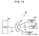
- An information-processing system searches a travel route of a mobile body using a server connected to a terminal unit in a manner capable of transmitting/receiving various information over a network
- the terminal unit including: a current-position information generator for generating current-position information about a current-position of the mobile body; a destination information generator for generating destination information about a position of a destination to which the mobile body travels; a way point information generator for generating way point information about a way point to which the mobile body travels; a route setting section for acquiring route information about a candidate route from the current-position of the mobile body to the destination and for generating route setting information including an instruction to set the candidate route as a guidance route; a terminal notification controller for controlling a notifying section that notifies the guidance route; and a terminal transceiver for transmitting to the server the current-position information, the destination information, the way point information and the route setting information and for receiving from the server the route information over the network, the server including: a current-position information generator for
- An information-processing method includes the steps of: acquiring current-position information about a current-position of a mobile body; acquiring destination information about a position of a destination to which the mobile body travels; searching a candidate route from the current-position of the mobile body to the destination according to the current-position information and the destination information; setting the candidate route as a guidance route; and searching a new route from the current-position of the mobile body to the destination including at least a section of the guidance route as well as a way point when it is recognized that new way point information about the way point to which the mobile body travels is acquired after the guidance route is set.
- An information-processing program executes the above information-processing method by a computer.
- a recording medium stores the above information-processing program in a manner readable by a computer.
- a navigation device of this embodiment is an example of an information-processing device of the present invention, which is designed to navigate a mobile body (e.g. a vehicle) driving concerning with a travel status.
- the information-processing device of the present invention may be applied to such a configuration that notifies the traffic condition of any mobile body without limiting to a configuration for navigating a vehicle.
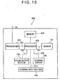
- Fig. 1 is a block diagram showing the brief configuration of the navigation device according to the first embodiment.
- Fig. 2 is a conceptual diagram schematically showing a table structure for display data of map information.
- Fig. 3 is a conceptual diagram schematically showing a table structure for matching data of the map information.
- Fig. 4 is a block diagram showing the brief configuration of a processor of the navigation device.
- the reference numeral 100 denotes the navigation device.
- the navigation device 100 notifies guidance for a travel along with a travel status of a mobile body (e.g. a vehicle).
- the mobile body is not limited to a vehicle, but includes any types of mobile body such as an aircraft and a ship.
- the navigation device 100 may be, for example, an in-vehicle unit installed in a vehicle as a mobile body, a portable unit, a PDA (Personal Digital Assistant), a mobile phone, a PHS (Personal Handyphone System) or a portable personal computer.
- the navigation device 100 searches and displays information about a current-position and a destination, a route from the current-position to the destination which passes or does not pass a way point, retrieves for and displays predetermined shops nearby, and displays information about service contents offered by those shops on the basis of map information owned by the navigation device 100.
- the way point is not limited to a point where a vehicle actually stops by, and, includes a point around the point where a vehicle drives through.
- the navigation device 100 has a sensor 110, a VICS (Vehicle Information Communication System) receiver 120, a terminal input section 130, a terminal display 140 functioning as a notifying section, a sound output section 150, a storage 160, a memory 170, a processor 180 and so on.
- VICS Vehicle Information Communication System
- the sensor 110 detects the traveling condition of a vehicle as a mobile body, i.e. the current position and the driving status, and outputs it as a predetermined signal Ssc to the processor 180.
- the sensor 110 for instance, has a GPS (Global Positioning System) receiver (not shown) and various sensors (not shown) such as a speed sensor, an azimuth sensor and an acceleration sensor.
- GPS Global Positioning System
- the GPS receiver receives electric navigation waves output from a GPS satellite (not shown), which is an artificial satellite, via a GPS antenna (not shown). Then, the GPS receiver calculates simulated coordinate values of the current-position on the basis of a signal corresponding to the received electric navigation waves and outputs the calculated coordinate values as a GPS data to the processor 180.
- the speed sensor of the sensor 110 is arranged on a mobile body (e.g. a vehicle) to detect the driving speed and the actual acceleration of the vehicle on the basis of a signal that varies depending on the driving speed, or the traveling speed, of the vehicle.
- the speed sensor reads a pulse signal, a voltage value and the like output due to the revolution of the axles and the wheels of the vehicle. Then, the speed sensor outputs detection information such as the read pulse signal and the voltage value to the processor 180.
- the azimuth sensor is arranged on the vehicle and provided with a so-called gyro-sensor (not shown) so as to detect the azimuth of the vehicle, i.e., the driving direction to which the vehicle is heading.
- the azimuth sensor outputs a signal representing detection information about the detected driving direction to the processor 180.
- the acceleration sensor is arranged on the vehicle to detect the acceleration of the vehicle in the driving direction thereof.
- the acceleration sensor converts the detected acceleration into a sensor output value, which is detection information as according to the pulse and the voltage, and then outputs the sensor output value to the processor 180.
- the VICS receiver 120 has a VICS antenna (not shown) and acquires traffic information via the VICS antenna. More specifically, the VICS receiver 120 acquires traffic information (hereinafter referred to as VICS data) about traffic-congestions, traffic accidents, constructions, traffic controls and so on from the VICS (not shown) by way of a beacon, FM multiplex broadcasting or the like. The acquired traffic information is output as a predetermined signal Svi to the processor 180.
- VICS data traffic information about traffic-congestions, traffic accidents, constructions, traffic controls and so on from the VICS (not shown) by way of a beacon, FM multiplex broadcasting or the like.
- the acquired traffic information is output as a predetermined signal Svi to the processor 180.
- the terminal input section 130 which may be a keyboard, a mouse or the like, has various operation buttons and operation knobs (not shown) to be used for input operations.
- the operation buttons and the operation knobs are used to input, for example, setting items for setting the operation contents of the navigation device 100.
- the above setting items include settings of contents and requirements for information to be acquired, settings of the destination and the way point, settings related to a route to be searched, retrieval for information, and displaying the driving condition, i.e., the travel status of the vehicle.
- the terminal input section 130 outputs a predetermined signal Sin to the processor 180 so as to apply the settings.
- the terminal input section 130 may include any types of input unit such as a touch panel that may be arranged at the terminal display 140 and a sound input section for the input operations as long as various setting items can be set.
- the terminal display 140 displays a signal Sdp representing image data sent from the processor 180.
- the image data may be those representing map information and retrieval information, TV image data received by a TV receiver (not shown), image data stored in an external device or recording medium such as an optical disc, a magnetic disk or a memory card and read by a drive or a driver, and image data from the memory 170.
- the terminal display 140 may typically be a liquid-crystal panel, an organic EL (Electro Luminescence) panel, a PDP (Plasma Display Panel), a CRT (Cathode-Ray Tube), a FED (Field Emission Display), or an electrophoretic display panel.
- the sound output section 150 has a sound generator such as a speaker (not shown). Under the control of the processor 180, the sound output section 150 outputs various signals Sad as sounds from the sound generator. The various signals Sad represent the sound data etc. from the processor 180. Information output as sounds, which may be the driving direction,'the driving status, the traffic condition and the like of the vehicle, are notified to a passenger such as a driver of the vehicle for navigating the vehicle.
- the sound generator may output TV sound data received by a TV receiver (not shown) and sound data stored in a recording medium or the memory 170. In place of the sound generator, the sound output section 150 may use a sound generator equipped on the vehicle.
- the storage 160 readably stores map information as shown in Figs. 2 and 3.
- the storage 160 may be drives or drivers for readably storing data on a recording medium such as a HD (Hard Disk), a DVD (Digital Versatile Disc), an optical disc and a memory card.
- a recording medium such as a HD (Hard Disk), a DVD (Digital Versatile Disc), an optical disc and a memory card.
- the map information includes display data VM, which is so-called POI (Point Of Interest) data as shown in Fig. 2, matching data MM as shown in Fig. 3, travel route search map information and the like.
- POI Point Of Interest
- the display data VM includes, for example, a plurality of display mesh information VMx, each having a unique number.
- the display data VM is divided into a plurality of display mesh information VMx, each relating to an area.
- the display data VM is constituted from the plurality of display mesh information VMx continuously arranged in a matrix form.
- the display mesh information VMx may be further divided into a plurality of display mesh information VMx to be contained in a lower layer, each relating to a smaller area.
- the display mesh information VMx is, for instance, constituted from name information VMxA such as intersection names, road information VMxB and background information VMxC.
- the name information VMxA is data structured in a table for arranging and displaying miscellaneous element data (e.g. intersection name, town name) contained in an area at a predetermined position with reference to the positional relationship based on the absolute coordinates.
- the road information VMxB is data structured in a table for arranging and displaying road element data (e.g. road) contained in an area at a predetermined position with reference to the positional relationship based on the absolute coordinates.
- the background information VMxC is data structured in a table for arranging and displaying miscellaneous element data (e.g. mark and image information representing famous spots and buildings) at a predetermined position with reference to the positional relationship based on the absolute coordinates.
- the matching data MM is divided into a plurality of matching mesh information MMx, each having a unique number and relating to an area.
- the matching data MM is constituted from the plurality of matching mesh information MMx continuously arranged in a matrix form.
- the matching mesh information MMx may be further divided into a plurality of matching mesh information MMx to be contained in a lower layer, each relating to a smaller area.
- the matching mesh information MMx and the display mesh information VMx may not necessarily represent the same area. That is, they may be divided according to different scales.
- the matching data MM is used for the map matching processing for correcting the displayed information to locate a mark representing the vehicle on a road, when the traveling condition of the vehicle is superimposed on the map information. This processing prevents such errors that the mark representing the vehicle is displayed on a building instead of the road.
- the matching data MM has a plurality of link string block information.
- the link string block information is data structured in a table so that a plurality of links L are mutually associated according to a predetermined rule.
- the link L as segment information represents a road and connects nodes N as the point information.
- the links L each corresponding to a predetermined segment of a road are mutually connected like a line as a link string, which represents a continuous road such as Koshu street and Ome street.
- Each link L has unique segment information (hereafter referred to as a link ID) as a unique number assigned to each link L, and node information as a unique number indicating two nodes N connected by the link L.
- Each link L is associated with a VICS link, so that the positional relationship between the VICS data and the displayed map can be corresponded with each other.
- Each node N represents a joint point such as an intersection, a comer, a fork, a junction or the like of each road.
- Information about the node N has unique point information as a unique number assigned to each node N in the link string block information, coordinate information of the position where each node N is located, and flag information as branching information describing whether the node N represents a branching position (e.g. intersection, fork) where a plurality of links are crossed or not.
- the link string block information of the matching data MM is associated with information about the road structure that describes, for example, the number of lanes, the width of road, the number of lights, whether it is a main line or not, whether it is a national road or a state road, a road type such as a toll road, a tunnel structure and the like. Based on the information about the road structure, roads can be displayed on a map corresponding to the display data VM. Additionally, cost information, in which the above-described information about the configuration of the road, is associated with the link string block information.
- the travel route search map information is structured in a table, which is similar to that of the matching data MM, including the point information for representing points such as the nodes N representing roads, and the segment information for connecting points such as the links L.
- the information is so structured to represent roads for searching the travel route.
- the storage 160 stores the retrieval information for acquiring information of a predetermined point in the map information. More specifically, the retrieval information includes various information about contents and guidance such as names of states, cities, regions and points, which are units used to gradually divide the map information into smaller areas, as well as various information about shops as points.
- the retrieval information is structured in a tree structure table so that item information are hierarchically associated with each other.
- the memory 170 readably stores the setting items to be input through the terminal input section 130, music data, image data and the like.
- the memory 170 also stores various programs that run on the OS (Operating System) controlling the whole operation of the navigation device 100.
- the memory 170 may preferably be a CMOS (Complementary Metal-Oxide Semiconductor) memory that retains the stored data even in the case of a sudden power interruption caused by a blackout.
- the memory 170 may include drives or drivers for readably storing data on a recording medium such as a HD, a DVD, or an optical disc.
- the processor 180 has various input/output ports (not shown) including a VICS receiving port connected to a VICS antenna, a GPS receiving port connected to a GPS receiver, sensor ports respectively connected to various sensors, a key input port connected to the terminal input section 130, a display control port connected to the terminal display 140, a sound control port connected to the sound output section 150, a storage port connected to the storage 160 and a memory port connected to the memory 170. As shown in Fig.
- the processor 180 includes as various programs a current-position recognizer 181 as a current-position information acquirer, a destination recognizer 182 as a destination information acquirer, a way point recognizer 183 as a way point information acquirer, a guidance notifying section 184, a display controller 185, a map matching section 186, a route search section 187, a research section 188, a route setting section 189, an information retriever 190 and the like.
- the current-position recognizer 181 recognizes the current-position of the vehicle. More specifically, the current-position recognizer 181 calculates a plurality of current simulated positions of the vehicle on the basis of the speed data and the azimuth data of the vehicle output respectively from the speed sensor and the azimuth sensor of the sensor 110. The current-position recognizer 181 further recognizes the current simulated coordinate values of the vehicle on the basis of the GPS data about the current-position output from the GPS receiver. Then, the current-position recognizer 181 compares the calculated current simulated positions with the recognized current simulated coordinate values, and calculates the current-position of the vehicle on the map information separately acquired so as to recognize the current-position.
- the current-position recognizer 181 determines a slope angle and an altitude of a road for driving on the basis of the acceleration data output from the acceleration sensor and calculates the current simulated position of the vehicle so as to recognize the current-position.
- the current-position of the vehicle can be accurately recognized even if the vehicle is on an intersection with an overpass or on an elevated highway where roads are overplayed in a two-dimensional view.
- the current-position recognizer 181 corrects the difference between the travel distance obtained only on the basis of the speed data and the azimuth data and the actual driving distance of the vehicle by using the detected slope angle of the road to accurately recognize the current-position.
- the current-position recognizer 181 can recognize not only the current-position of the vehicle as described above but also a starting point, i.e. an initial point set by the terminal input section 130 as the current simulated position.
- the current-position recognizer 181 generates travel status information indicating the travel status of the vehicle as needed. To be more specific, when recognizing the current-position of the vehicle, the current-position recognizer 181 appropriately determines whether or not the current-position of the vehicle is located on a below-described first guidance route T1 (e.g., see Fig. 7), or on a second guidance route T2 (e.g., see Fig. 13) to be set by the route setting section 189. When recognizing that the current-position of the vehicle is located on the guidance route T1, T2, the current-position recognizer 181 appropriately generates the travel status information indicating that the vehicle travels based on the guidance route T1, T2.
- a below-described first guidance route T1 e.g., see Fig. 7
- a second guidance route T2 e.g., see Fig. 13
- the current-position recognizer 181 when recognizing that the current-position of the vehicle is not located on the guidance route T1, T2, the current-position recognizer 181 appropriately generates the travel status information indicating that the vehicle travels not based on the guidance route T1, T2.
- the travel status information is generated based on the determination whether or not the current-position of the vehicle is located on the guidance route T1, T2 as an example, a following configuration is available.
- such travel status information indicating that the vehicle travels based on the guidance route T1, T2 can be generated if it is recognized that the vehicle is located on the road around the guidance route T1, T2, or if it is recognized that the vehicle passes through, for instance, five arbitrary points or more which represent intersections etc. arranged on the guidance route T1, T2, or a road around the guidance route T1, T2.
- the various information is then appropriately stored in the memory 170.
- the destination recognizer 182 acquires the destination information about the destination set by the input operation at the terminal input section 130 and recognizes the position of the destination.
- the destination information includes various information for identifying a location, indicating coordinates such as latitude and longitude, addresses, telephone numbers and the like.
- the destination information is appropriately stored in the memory 170.
- the way point recognizer 183 acquires way point information about the way point set by the input operation through the terminal input section 130 and recognizes the position of the way point.
- the way point information may be various information similar to the destination information, however, it is not limited thereto.
- the way point information is then appropriately stored in the memory 170.
- the guidance notifying section 184 notifies guidance on the travel of the vehicle, for instance, the contents for assisting the drive of the vehicle stored in the memory 170 in visual form by using the terminal display 140 or in audio form by using the sound output section 150 on the basis of research route information or candidate route information and feature guidance information acquired in advance according to the driving status of the vehicle.
- a predetermined arrow and a sign may be displayed on the display screen of the terminal display 140, or a voice guidance such as "Turn right toward XX at the intersections of YY 700m ahead", "The vehicle is off the travel route" or "A traffic-congestion is ahead” may be provided from the sound output section 150.
- the display controller 185 controls the terminal display 140 so that the various information can be displayed on the terminal display 140. Additionally, the display controller 185 displays various display screens prompting a user to input for setting the various information using the terminal input section 130.
- the map' matching section 186 performs the map matching processing for displaying the current-position recognized by the current-position recognizer 181 based on the map information acquired from the storage 160. As described earlier, the map matching section 186 typically uses the matching data MM for performing the map matching processing to modify or correct the current-position information to prevent the current-position superimposed on the map on the terminal display 140 from being located off the road.
- the route search section 187 searches a travel route by calculating a candidate route of the vehicle on the basis of the setting information that is set by a user for setting the route, the VICS data acquired by the VICS receiver 120, the map information stored in the storage 160 and the like.
- the route search section 187 acquires the current-position information, the destination information, the VICS data and the setting information. Based on the acquired various information, a road allowing the vehicle to drive is searched using the travel route search map information contained in the map information. Thereafter, when the setting information includes such information requesting for searching a plurality of candidate routes, the route search section 187 generates a plurality of candidate route information setting a candidate route Rj (j representing a natural number, see Fig. 6 for example) with the least travel time, a candidate route Rj with the shortest travel distance, or a candidate route Rj avoiding the traffic-congestion and the location of the traffic control or the like.
- a candidate route Rj j representing a natural number, see Fig. 6 for example
- the route search section 187 when the setting information includes such information requesting for searching one candidate route, the route search section 187 generates single candidate route information setting a candidate route Rp (see Fig. 8) having the minimum cost, in consideration of the travel time and the travel distance. While such a configuration is exemplified here that generates the candidate route information setting the one candidate route Rp having the minimum cost, it is not limited thereto, and a configuration that generates candidate route information setting one candidate route Rp with the least travel time or the shortest travel distance.
- the acquired candidate route information is appropriately stored in the memory 170.
- the matching data MM of the map information is possibly used in addition to the travel route search map information. This applies to, for instance, the case where the candidate route is searched using a road not contained in the travel route search map information, such as a narrow road, e.g., a back street.
- the candidate route information includes, for example, the route guidance information for navigating the vehicle to assist the driving thereof. Under the control of the guidance notifying section 184, the route guidance information may be appropriately displayed on the terminal display 140 or output as sounds from the sound output section 150 to assist the driving.
- the research section 188 researches a first research route Qj (j representing a natural number, see Fig. 11 for example) as a new route giving preference to the first guidance route T1 set by the route setting section 189, or a second research route Pi (i representing a natural number, see Fig. 10 for example) not giving preference to the first guidance route T1.
- Giving preference to the first guidance route T1 means that the new route includes at least a section of the first guidance route T1 and is similar to the first guidance route T1.
- not giving preference to the first guidance route T1 means that the new route is not similar to the first guidance route T1.
- the second research route Pi not giving preference to the first guidance route T1 may occasionally include a section of the first guidance route T1.
- the research section 188 calculates the distance of a section of the first guidance route T1 contained in each of the researched first research routes Qj to generate research route information setting a first research route Qj with the section of the first guidance route T1 being the longest.
- a configuration is also available that determines whether or not each of the first research routes Qj includes a traffic-congestion section, and generates single research route information setting a first research route Qj having no or fewer traffic-congestion sections.
- the research section 188 generates single research route information setting, for instance, a second research route Pi with the minimum cost out of the researched second research routes Pi. While the configuration is exemplified here that generates the research route information setting the second research route Pi with the minimum cost, it is not limited thereto, and a configuration that generates research route information setting a second research route Pi with the least travel time or the shortest travel distance, a second research route Pi having no traffic-congestion section, or a second research route Pi having fewer traffic-congestion sections.
- the research route information is appropriately stored in the memory 170.
- the research route information includes, for example, the route guidance information for navigating the vehicle to assist the driving thereof similar to the candidate route information.
- the route setting section 189 sets the first guidance route T1 as the guidance route according to the candidate route information generated by the route search section 187.
- the route setting section 189 also resets the second guidance route T2 as the guidance route according to the research route information generated by the research section 188.
- the route setting section 189 recognizes the candidate route information about the candidate route Rj selected according to the route selecting information. The route setting section 189 then sets the candidate route Rj as the first guidance route T1 according to the recognized candidate route information. Further, when acquiring the candidate route information about the candidate route Rp after recognizing that the route search section 187 has searched the one candidate route Rp, the route setting section 189 automatically sets the candidate route Rp as the first guidance route T1 according to the candidate route information.
- the route setting section 189 may automatically sets such a candidate route Rj as the first guidance route T1.
- the route setting section 189 automatically reset the first research route Qj or the second research route Pi as the second guidance route T2 according to the research route information.
- the information retriever 190 hierarchically retrieves and acquires the retrieval information, such as shops and facilities, stored in the storage 160 on the basis of the item information in response to, for example, a retrieval request for the retrieval information set at the terminal input section 130. Besides, the information retriever 190 appropriately searches the retrieval information stored in the storage 160 based on a retrieval method or the like included in way point retrieval method information input through, for instance, the terminal input section 130, and acquires at least single retrieval information about the way point as the way point information.
- the retrieval method includes vehicle vicinity retrieval for searching the points around the current-position of the vehicle, route vicinity retrieval for searching the points around the respective guidance routes T1 and T2, coordinate retrieval for searching based on the coordinates such as latitude and longitude, address retrieval, phone number retrieval or the like, it is not limited thereto.
- Fig. 5 is a flowchart showing the processing for setting the first guidance route.
- Fig. 6 is a conceptual diagram showing a plurality of candidate routes searched by the route search section.
- Fig. 7 is a schematic illustration showing a display screen at the time when one of the plurality of candidate routes is set as the first guidance route.
- Fig. 8 is a schematic illustration showing a display screen at the time when, after the one candidate route is requested for search, the searched candidate route is set as the first guidance route.
- a user on the vehicle i.e., a passenger turns on the navigation device 100 to supply the power thereto.
- the processor 180 controls the terminal display 140 by the display controller 185 to display a main menu and a display screen prompting the user to set a specific operation to be executed by the navigation device 100.
- the user then operates the terminal input section 130 to set a command for searching a candidate route to travel.
- the processor 180 makes the display controller 185 display on the terminal display 140 a display screen prompting the user to set various information necessary for searching the candidate routes, such as the destination, the setting information indicating whether or not the plurality of candidate routes are searched.
- the processor 180 recognizes the current-position by the current-position recognizer 181 (step S102), and then recognizes the set destination by the destination recognizer 182 (step S103). Specifically, the current-position recognizer 181 calculates the current-position of the vehicle on the basis of the speed data and the azimuth data of the vehicle respectively output from the speed sensor and the azimuth sensor of the sensor 110 and the GPS data about the current-position output from the GPS receiver, and acquires the current-position information. The acquired current-position information is appropriately stored in the memory 170.
- the processor 180 controls the terminal display 140 by the display controller 185 to display a screen prompting the user to set the destination with the input operation through the terminal input section 130. Then, when the user sets the destination by input operation through the terminal input section 130 following the instructions on the display screen, the destination recognizer 182 acquires the destination information about the set destination. The acquired destination information is appropriately stored in the memory 170.
- the processor 180 makes the information retriever 190 hierarchically retrieve the retrieval information about the destination from the mesh information at the lower layers for each area, typically using the map information, and acquire the retrieval information associated with the point of the destination from the storage 160. Then, the display controller 185 of the processor 180 controls the terminal display 140 to display the acquired retrieval information.
- the display controller 185 appropriately controls the terminal display 140 to display the display mesh information VMx for the corresponding area.
- the user identifies the point information of the destination by appropriately setting the point of the destination with the input operation at the terminal input section 130, for example, by moving the cursor displayed on the map on the screen.
- the destination recognizer 182 of the processor 180 recognizes the point information of the destination as the destination information and stores it in the memory 170.
- the processor 180 controls the terminal display 140 by the display controller 185 to display an indication prompting the user to input the setting items, i.e., requirements for searching the candidate route.
- the processor 180 acquires the setting information about the setting items (step S104).
- the setting information is appropriately stored in the memory 170.
- the processor 180 has the route search section 187 acquire the setting information stored in the memory 170 and determines whether or not the setting information contains the request for searching the plurality of candidate routes (step S105).
- the processor 180 when recognizing that the request for searching the plurality of candidate routes is contained, acquires the current-position information, the destination information and the setting information from the memory 170. Besides, the processor 180 acquires the VICS data by the VICS receiver 120. Based on the various information, the processor 180 then performs a route search processing to search the plurality of candidate routes Rj from the current-position of the vehicle to the destination, using the travel route search map information and the matching data MM stored in the storage 160 (step S 106).
- the route is searched using the travel route search map information.
- searching a minor street of which data is not stored in the travel route search map information the route from a minor street to a major street is searched using the matching data MM.
- the route search section 187 detects the plurality of routes, narrows down the number of routes according to the acquired setting information, and then generates the candidate route information about a plurality of, for example, five candidates routes Rj from the current-position S of the vehicle to the destination G as shown in Fig. 6, meeting the requirements preferred by the user.
- the processor 180 operates the display controller 185 to display, for instance, the five candidate routes Rj on the terminal display 140 as shown in Fig. 6 by superimposing the routes one-by-one on the map information based on the candidate route information about the five candidate routes calculated by the route search section 187, as well as a screen prompting the user to set the route selecting information to select one of the displayed candidate routes Rj.
- the plurality of candidate routes Rj may be displayed on the terminal display 140 by superimposing on the map information at the same time.
- the processor 180 makes the route setting section 189 recognize the setting of the route selecting information by the input operation of the user, and set the first guidance route T1 according to the candidate route information about the candidate route Rj selected by this route selecting information (step S107).
- the processor 180 when recognizing the setting of the route selecting information indicating that a candidate route R1 as shown in Fig. 6 has been selected, the processor 180 sets the candidate route R1 as a first guidance route T1 according to the route selecting information. Then, the candidate route information about the candidate route R1 set as the first guidance route T1 is stored in the memory 170 as route setting information.
- step S105 when recognizing the request for searching one candidate route, the processor 180 performs the same processing as the step S106, and then performs a route search processing for searching one candidate route Rp from the current-position of the vehicle to the destination (step S108).
- the route search section 187 detects the plurality of routes according to the travel route search map information, the matching data MM and the like, and then generates, from the detected routes, single candidate route information about one candidate route Rp identical to, for instance, the candidate route R4 as shown in Fig. 6, the route having the minimum cost, in consideration of the travel time and the travel distance.
- the processor 180 has the route setting section 189 automatically set the first guidance route T1 according to the single candidate route information generated in the step S108. In other words, the processor 180 performs the processing of the step S107. For example, when recognizing by the route setting section 189 that the single candidate route information about the candidate route Rp having the minimum cost has been generated as shown in Fig. 6, the processor 180 automatically sets the candidate route Rp as the first guidance route T1 according to the candidate route information. Then, the candidate route information about the candidate route Rp set as the first guidance route T1 is stored in the memory 170 as route setting information.
- the processor 180 then performs the navigation based on the first guidance route T1 set in the step S107 (step S109).
- the processor 180 acquires the map information from the storage 160.
- the processor 180 operates the display controller 185 to display the candidate route R1 on the terminal display 140 as the first guidance route T1 according to the candidate route information about the candidate route R1, as shown in Fig. 7, by superimposing it on the map information.
- the display controller 185 displays the candidate route Rp on the terminal display 140 as the first guidance route T1 according to the candidate route information about the candidate route Rp, as shown in Fig.
- the display controller 185 displays an icon As representing the current-position S of the vehicle based on the current position information and an icon Ag representing the destination G based on the destination information by superimposing them on the first guidance route T1.
- the processor 180 controls the guidance notifying section 184 so that the sound output section 150 outputs sounds to perform the navigation based on the first guidance route T1.
- the processor 180 recognizes the travel condition of the vehicle based on the data output from the speed sensor, the azimuth sensor and the acceleration sensor of the sensor 110 and the GPS data output from the GPS receiver. Then, the processor 180 operates the current-position recognizer 181 and the guidance notifying section 184 to notify the guidance information about the travel of the vehicle in visual or audio form on the basis of the recognized travel condition and route guidance information contained in the candidate route information for navigating the travel of the vehicle.
- the display controller 185 of the processor 180 interconnects the nodes N in the matching mesh information MMx acquired from the storage 160 with a polyline and performs a polyline processing on the basis of the arrangement of roads described in the link string block information of the matching data MM so as to display the roads in the area of the matching mesh information MMx containing the first guidance route T1 on the terminal display 140. Additionally, the display controller 185 superimposes the name information VMxA and the background information VMxC that are miscellaneous element data about the elements of the map excluding roads of the display mesh information VMx in the area corresponding to the matching mesh information MMx acquired from the storage 160. Then, the current-position is superimposed on the displayed map.
- the map matching processing is performed on the basis of the matching data MM to prevent an indication representing the current-position information of the vehicle from being located off the road.
- the processor 180 appropriately corrects the current-position information so that the current-position is located on the first guidance route T1 in the matching data MM.
- the current-position is displayed on the link string connecting links L. In this way, the current-position is superimposed on the map for the navigation.
- guidance on the traveling direction and the like are provided in visual or audio form.
- the map will be displayed based on the display mesh information VMx acquired from the storage 160 as in the case of the display operation based on the retrieval.
- the processor 180 operates the route search section 187 to acquire the VICS data about, for instance, the traffic-congestions, traffic accidents, constructions and traffic controls, and weather information.
- the processor 180 searches a candidate route again according to the acquired VICS data and the weather information in the case that the traveling condition of the vehicle may be affected or changed.
- the processor 180 has the guidance notifying section 184 notify the guidance on the change or affection.
- the processor 180 makes the current-position recognizer 181 recognize the current-position of the vehicle and determine whether or not the current-position of the vehicle is located on the first guidance route T1.
- travel status information indicating that the vehicle travels based on the first guidance route T1 is generated.
- travel status information indicating that the vehicle travels not based on the first guidance route T1 is generated.
- the travel status information is appropriately stored in the memory 170.
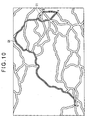
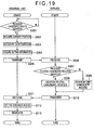
- Fig. 9 is a flowchart showing a processing for resetting the second guidance route.
- Fig. 10 is a schematic illustration of a display screen showing an example of a first research route.
- Fig. 11 is a schematic illustration of a display screen at the time when the second research route is reset as a second guidance route.
- Fig. 12 is a schematic illustration of a display screen showing an example of a second research route.
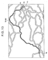
- Fig. 13 is a schematic illustration of a display screen when the first research route is reset as the second guidance route.
- the user operates the terminal input section 130 to set, for instance, an instruction for searching a way point where the vehicle passes through.
- the processor 180 controls the display controller 185 to display on the terminal display 140 a display screen prompting the user to set the way point retrieval method information about the retrieval method of the way point.
- the processor 180 When acquiring the way point retrieval method information, the processor 180 makes the information retriever 190 recognize the retrieval method of the way point according to the way point retrieval method information (step S202). While the retrieval method of the way point may be applied to vehicle vicinity retrieval, route vicinity retrieval, coordinate retrieval, address retrieval, phone number retrieval or the like, it is not limited thereto.
- the information retriever 190 appropriately searches the retrieval information stored in the storage 160 according to the retrieval method recognized in the step S202 to acquire at least single way point information about the way point. Then the processor 180 operates the information retriever 190 to generate candidate way point information including the acquired way point information (step S203).
- the processor 180 has the way point recognizer 183 acquire the way point information (step S204).
- the processor 180 controls the display controller 185 to display on the terminal display 140 the way point information contained in the candidate way point information, and to display an indication prompting the user to set way point selecting information instructing selection of one of the way point information.
- the processor 180 then makes the way point recognizer 183 recognize the setting of the way point selecting information by the input operation of the user, and acquire the way point information selected on account of the recognized way point selecting information.
- the acquired way point information is appropriately stored in the memory 170.
- the processor 180 has the research section 188 determine whether or not the plurality of candidate routes have been searched based on the determination in the processing of the step S105 by way of the route search section 187 (step S205).
- the research section 188 when determining that the plurality of candidate routes have not been searched by the route search section 187, the research section 188 recognizes that the one candidate route Rp, for instance, having the minimum cost searched by the route search section 187 is automatically set as the first guidance route T1 as shown in Fig. 8.
- the research section 188 recognizes that the user need not travel based on the first guidance route T1 after passing the way point, since the first guidance route T1 is not the candidate route Rj selected by the user's decision from the plurality of candidate routes Rj. Thereafter, the research section 188 researches a second research route Pi (step S206).
- the research section 188 acquires the current-position information, the destination information, the setting information and the way point information from the memory 170.
- the processor 180 acquires the VICS data by the VICS receiver 120.
- the research section 188 researches the second research route Pi based on the various information using the travel route search map information stored in the storage 160. After that, the research section 188 detects a plurality of second research routes Pi, and then generates research route information about a second research route Pi, for instance, having the minimum cost in consideration of the travel time and the travel distance out of these second research routes Pi.
- the processor 180 operates the route setting section 189 to automatically reset the second research route Pi as the second guidance route T2 according to the one research route information generated by the research section 188 (step S207). Then, the research route information about the second research route Pi reset as the second guidance route T2 is stored in the memory 170 as route setting information.
- the research section 188 recognizes that the candidate route Rj, which is selected by the user out of the plurality of candidate routes Rj, is set as the first guidance route T1.
- the research section 188 recognizes that the user wants to travel based on the first guidance route T1 after passing the way point, since the first guidance route T1 is the candidate route Rj selected by the user's decision.
- the processor 180 has the research section 188 determine whether or not the vehicle travels based on the first guidance route T1 (step S208). In other words, the research section 188 acquires the travel status information from the memory 170, and determines whether or not the vehicle travels based on the first guidance route T1 according to the contents included in the acquired travel status information.
- the research section 188 When determining that the vehicle travels not based on the first guidance route T1 in the step S208, the research section 188 recognizes that the user need not to travel based on the first guidance route T1 after passing the way point. The processor 180 then performs the processing of the step S206 and S207. To be more specific, the processor 180 operates the research section 188 to research a plurality of second research routes Pi, and to generate research route information about the second research route Pi, for instance, with the minimum cost out of the searched second research routes Pi. Then, the processor 180 makes the route setting section 189 automatically reset the second research route Pi of the research route information as the second guidance route T2.
- the research section 188 recognizes that the user wants to travel based on the first guidance route T1 after passing the way point.
- the research section 188 determines whether the retrieval method of the way point recognized in the step S202 is the vehicle vicinity retrieval or the route vicinity retrieval (step S209).
- the research section 188 recognizes that the way point which is not the vicinity of the first guidance route T1 may be searched based on this retrieval method.
- the research section 188 recognizes that the user need not travel based on the first guidance route T1 after passing the way point, in the case that the way point which is not the vicinity of the first guidance route T1 is searched. Thereafter, the processor 180 performs the processing of the step S206 and S207.
- the research section 188 recognizes that only the way point around the first guidance route T1 is searched by the retrieval based on this retrieval method.
- the research section 188 recognizes that the user wants to travel based on the first guidance route T 1 after passing the way point, since only the way point around the first guidance route T1 is searched.
- the research section 188 determines whether or not the way point specified by the way point information acquired in the step S204 represents a facility allowing the vehicle to travel quickly such as a highway or a ferry terminal (step S210).
- a highway or a ferry terminal is exemplified as a facility allowing the vehicle to travel quickly, it is not limited thereto.
- the research section 188 recognizes that the user wants to travel quickly to the destination even if the route is not corresponding to the first guidance route T1 after passing the way point.
- the processor 180 then performs the processing of the step S206 and S207.
- the research section 188 recognizes that the user wants to travel based on the first guidance route T1 after passing the way point. The research section 188 then determines whether or not a passing-through distance Y which is a sectional distance from the way point to the guidance route, i.e., the distance from the first guidance route T1 to the way point, is shorter than a predetermined distance A preset as, for example, 500m (step S211).
- the research section 188 acquires the way point information and the route setting information about the first guidance route T1 from the memory 170. Based on the acquired information, the research section 188 calculates the shortest distance from the first guidance route T1 to the way point as the passing-through distance Y, and recognizes whether or not the calculated passing-through distance Y is 500m or shorter. The calculated passing through distance Y is appropriately stored in the memory 170. Note that, while the predetermined distance A is set as 500m, it is not limited thereto, and the predetermined distance A may be 100m or 1km.
- the research section 188 recognizes that the user need not travel based on the first guidance route T1 after passing the way point, because the way point is away from the first guidance route T1.
- the processor 180 then performs the processing of the step S206 and S207.
- the research section 188 recognizes that the user wants to travel based on the first guidance route T1 after passing the way point, because the way point is around the first guidance route T1.
- the research section 188 determines whether or not a passing-through distance ratio Z, or a ratio representing a value in which the passing-through distance Y is divided by the route distance X as a sectional distance of the guidance route representing the entire distance of the first guidance route T1 is smaller than a predetermined ratio B preset as, for instance, 0.1 (step S212).
- the research section 188 acquires the route distance Y and the route setting information from the memory 170, and calculates the route distance X of the first guidance route T1 based on the acquired route setting information. Then, the passing-through distance ratio Z is obtained since the route distance Y calculated in the step S211 is divided by the route distance X, and determines whether or not the obtained passing-through distance ratio Z is 0.1 or less.
- the calculated route distance X and the passing-through distance ratio Z are appropriately stored in the memory 170.
- the predetermined ratio B is set as 0.1, it is not limited thereto, and the predetermined ratio B may be 0.01 or 1.
- the research section 188 recognizes that the distance from the way point to the first guidance route T1 is relatively long, and thus recognizes that the way point is relatively away from the first guidance route T1.
- the research section 188 recognizes that the user need not travel based on the first guidance route T1 after passing the way point, since the way point is relatively away from the first guidance route T1.
- the processor 180 performs the processing of the step S206 and S207.
- the research section 188 when determining that the passing-through distance ratio Z is smaller than the predetermined ratio B in the step S212, the research section 188 recognizes that the distance from the way point to the first guidance route T1 is relatively short, and thus recognizes that the way point is a point relatively close to the first guidance route T1. The research section 188 recognizes that the user wants to travel based on the first guidance route T1 after passing the way point, because the way point is relatively close to the first guidance route T1. Thereafter, the research section 188 researches a first research route Qj (step S213).
- the research section 188 acquires the current-position information, the destination information, the way point information and the setting information from the memory 170.
- the processor 180 acquires the VICS data by the VICS receiver 120.
- the research section 188 acquires the candidate route information related to the first guidance route T1 from the memory 170.
- the research section 188 researches the first research route Qj based on the acquired various information using the travel route search map information stored in the storage 160. Then, the research section 188 detects a plurality of first research routes Qj and calculates a distance of a section of the first guidance route T1 included in each of the first research routes Qj.
- the research section 188 generates research route information about the first research route Qj of which the calculated distance of the section is the longest.
- the processor 180 operates the route setting section 189 to automatically reset the first research route Qj as the second guidance route T2 according to the single research route information generated by the research section 188. Namely, the processor 180 performs the processing of the step S206 and S207. Then, the research route information about the first research route Qj reset as the second guidance route T2 is stored in the memory 170 as route setting information.
- the processor 180 then performs the navigation based on the second guidance route T2 reset in the step S207 (step S214).
- the step 180 acquires the map information from the storage 160.
- the processor 180 makes the display controller 185 display the second guidance route T2 on the terminal display 140 according to the route setting information about the second guidance route T2 reset in the step S207.
- the processor 180 when determining that the passing-through distance Y is longer than the predetermined distance A at the processing of the step S211, the processor 180 resets the second research route Pi as the second guidance route T2 in the step S207. Therefore, the processor 180 makes the display controller 185 display, for example, the second research route P1 with the minimum cost as the second guidance route T2 dissimilar to the first guidance route T1 as shown in Fig. 11, instead of the first research route Q1 from the current-position S of the vehicle to the destination G passing the way point V, including a section of the first guidance route T1 and thus being similar to the first guidance route T1 as shown in Fig. 10.
- the processor 180 when determining that the passing-through distance ratio Z is smaller than the predetermined ratio B at the processing of the step S212, the processor 180 resets the first research route Qj as the second guidance route T2 in the step S213. Therefore, the processor 180 makes the display controller 185 display, for example, the first research route Q2 including a section of the first guidance route T1 and thus being similar to the first guidance route T1 as the second guidance route T2 as shown in Fig. 13, instead of the second research route P2 with the minimum cost from the'current-position S of the vehicle to the destination G passing the way point V and thus being dissimilar to the first guidance route T1 as shown in Fig. 12.
- the display controller 185 displays an icon As representing the current-position S of the vehicle based on the current-position information, an icon Ag representing the destination G based on the destination information, an icon Av representing the way point V based on the way point information and the like by superimposing them on the second guidance route T2 as shown in Figs. 11 and 13.
- the processor 180 controls the guidance notifying section 184 so that the sound output section 150 outputs sounds to perform the navigation based on the second guidance route T2.
- the processor 180 makes the route search section 187 search the respective candidate routes, and makes the current-position recognizer 181 generate the travel status information to store it in the memory 170.
- the processor 180 of the navigation device 100 operates the route search section 187 to acquire the current-position information, the destination information and the setting information stored in the memory 170.
- the processor 180 then makes the route search section 187 search a plurality of candidate routes Rj from the current-position to the destination based on the acquired various information, makes the route setting section 189 set one of the plurality of candidate routes Rj as a first guidance route T1 to store in the memory 170 as well as the candidate route information about the candidate route Rj, which is set as the first guidance route T1, as the route setting information.
- the processor 180 has the way point recognizer 183 store the way point information in the memory 170.
- the processor 180 When recognizing that the way point recognizer 183 has acquired the way point information, the processor 180 operates the research section 188 to research the first research route Qj to the destination, the route giving preference to the first guidance route T1, that is, the route to the destination passing the way point including at least a section of the first guidance route T1, according to the way point information and the route setting information.
- the navigation device 100 can research the first research route Qj including at least a section of the first guidance route T1 even after the first guidance route T1 has been set.
- the navigation device 100 can reset the first research route Qj reflecting the first guidance route T1 as the second guidance route T2 even after the first guidance route T1 has been set.
- the processor 180 makes the display controller 185 display the plurality of candidate routes Rj searched by- the route search section 187 on the terminal display 140, and also display an indication prompting the user to set the route selecting information for selecting one of these candidate routes Rj.
- the processor 180 has the route setting section 189 set the candidate route Rj, which is selected according to the route selecting information, as the first guidance route T1.
- the first research route Qj including a section of the first guidance route T1 intentionally selected by the user out of the plurality of candidate routes Rj, in other words, the first guidance route T1 that the user wants to drive continuously even after passing the way point can be researched.
- the navigation device 100 can reset the first research route Qj reflecting the first guidance route T1 desired by the user as the second guidance route T2.
- the processor 180 has the current-position recognizer 181 generate the travel status information including information whether or not the vehicle travels based on the first guidance route T1 and store it in the memory 170.
- the processor 180 makes the research section 188 research the first research route Qj to the destination passing the way point based on the first guidance route T1. Therefore, the navigation device 100 can research the first research route Qj based on the first guidance route T1 where the user intentionally travels without any obligations, that is, where the user wants to travel even after passing the way point.
- the navigation device 100 can reset the first research route Qj reflecting the first guidance route T1 desired by the user as the second guidance route T2 even after the first guidance route T1 has been set.
- the processor 180 makes the current-position recognizer, 181 determine whether or not the current-position of the vehicle is located on the first guidance route T1, and also determine whether or not the vehicle travels based on the first guidance route T1. According to this determination, the travel status information indicating whether or not the vehicle travels based on the first guidance route T1 is appropriately generated. Therefore, using the current-position recognizer 181, the processor 1-80 can determine whether or not-the vehicle travels-based on the first guidance route T1 by a simple method determining whether or not the current-position of the vehicle is located on the first guidance route T1. Accordingly, the processing time for generating the travel status information can be shortened.
- the processor 180 makes the research section 188 calculate the distance of a section of the first guidance route T1 contained in each of the first research routes Qj, and makes the route setting section 189 automatically reset the first research route Qj with the calculated distance of the section being the longest as the second guidance route T2. Therefore, the navigation device 100 can reset the first research route Qj the most similar to the first guidance route T1 where the user wants to travel even after passing the way point as the second guidance route T2. Thus, the navigation device 100 can reset the second guidance route T2 further reflecting the first guidance route T1 desired by the user.
- the processor 180 makes the research section 188 research the first research route Qj to the destination passing the way point based on the first guidance route T1. Because of this, when the way point located around the first guidance route T1 where the user wants to drive is set, the navigation device 100 can research the first research route Qj based on the first guidance route T1, and reset the first research route Qj. Accordingly, the navigation device 100 can reset the first research route Qj meeting with the user's wishes further as the second guidance route T2.
- the processor 180 makes the research section 188 research the first research route Qj to the destination passing the way point based on the first guidance route T1. Because of this, when the way point located relatively close to the first guidance route T1 where the user wants to drive is set, the navigation device 100 can research the first research route Qj based on the first guidance route T1, and then reset the first research route Qj. Accordingly, the navigation device 100 can reset the first research route Qj meeting with the user's wishes further as the second guidance route T2.
- the processor 180 makes the information retriever 190 search at least one way point based on the retrieval method of the way point contained in the way point retrieval method information set by the user, and generates the candidate way point information including the way point information about the searched way point.
- the way point recognizer 183 then acquires the way point information based on the way point selecting information set by the user. Therefore, the user can acquire the candidate way point information without the setting of specific information about the way point, and select to set the desirable candidate way point from the candidate way point information. Thus, the user can set the way point more easily.
- the processor 180 makes the research section 188 research the first research route Qj to the destination passing the way point based on the first guidance route T1. Because of this, when the user sets the way point located around the vehicle on which the user rides, the navigation device 100 can research the first research route Qj based on the first guidance route T1 where the user wants to drive, and reset the first research route Qj. Accordingly, the navigation device 100 can reset the first research route Qj meeting with the user's wishes further as the second guidance route T2.
- the processor 180 makes the research section 188 research the second research route Pi to the destination using a highway or the like regardless of the first guidance route T1, instead of the first research route Qj based on the first guidance route T1. Therefore, when the user sets, for instance, a highway which is a way other than the one driving on the first guidance route T1 because the user wants to travel quickly, the navigation device 100 can research the second research route Pi using a highway regardless of the first guidance route T1, and reset the second research route Pi. Accordingly, the navigation device 100 can reset the second research route Pi meeting with the user's wishes as the second guidance route T2.
- the processor 180 performs a following processing when researching the first research route Qj. That is, the route search section 187 searches the candidate routes Rj in ascending order of, for instance, the integration value of the cost information about the road. Note that, the numeric of the cost information is set smaller as the road is wider or has the larger number of lanes, causing the vehicle to drive more easily.
- the research section 188 then generates corrected cost information in which a predetermined value is subtracted from the numeric of the cost information about the road of the candidate route Rj set as the first guidance route T1, or alternatively generates corrected cost information in which the cost information is set as "0".
- the research section 188 When researching the route, the research section 188 then researches the first research route Qj or the second research route Pi having the smaller integration value of the cost information using the corrected cost information. Therefore, the processor 180 makes the research section 188 research the route including a section of the first guidance route T1 constituted by the road associated with the corrected cost information with the smaller numeric, namely, research the first research route Qj. Accordingly, the navigation device 100, with the use of the research section 188, can reset the first research route Qj as the second guidance route T2 by a simple configuration of researching the route having smaller integration value of the cost information about the road.
- a communication navigation system of this embodiment is an example of an information-processing system as an information-processing device of the present invention, and so designed to navigate the drive of a mobile body (e.g. a vehicle) along with the driving status.
- a mobile body e.g. a vehicle
- the information-processing system of the present invention is not limited to a configuration for navigating a vehicle, but includes a configuration for notifying the traffic condition of any mobile body.
- Fig. 14 is a block diagram showing the brief configuration of the navigation system according to the present embodiment.
- Fig. 15 is a block diagram showing the brief configuration of a terminal unit.
- Fig. 16 is a block diagram showing the brief configuration of a processor of the terminal unit.
- Fig. 17 is a block diagram showing the brief configuration of a server.
- Fig. 18 is a block diagram showing the brief configuration of a CPU of the server. The components same as those in the first embodiment are denoted respectively by the same reference symbols and will not be described any further.
- the reference numeral 200 denotes the communication navigation system (information-processing system).
- the navigation system 200 notifies guidance on a travel along with a travel status of a mobile body (e.g. a vehicle).
- the mobile body is not limited to a vehicle, but includes any types of mobile body such as an aircraft and a ship.
- the navigation system 200 has a network 300, a terminal unit 400 as an information-processing device, and a server 500.
- the network 300 is connected to the terminal unit 400 and the server 500.
- the network 300 interconnects the terminal unit 400 and the server 500 to enable the communication therebetween.
- the network 300 may be Internet based on a general-purpose protocol such as TCP/IP protocol, an intranet, a LAN (Local Area Network), a communication network and a broadcasting network that have a plurality of base stations capable of communicating by way of a radio medium, or the radio medium itself that enables direct communication between the terminal unit 400 and the server 500.
- the radio medium may be any one of electric waves, light beams, acoustic waves and electromagnetic waves.
- the terminal unit 400 may be, for example, an in-vehicle unit installed in a vehicle as a mobile body, a portable unit, a PDA (Personal Digital Assistant), a mobile phone, a PHS (Personal Handyphone System) or a portable personal computer.
- the terminal unit 400 acquires map information distributed by the server 500 over the network 300.
- the terminal unit 400 searches and displays information about a current-position and a destination, candidate routes, predetermined shops nearby, and information about service contents offered by the shops. As shown in Fig.
- the terminal unit 400 includes a transceiver 410 that operates as a terminal transceiver, a sensor 110, a terminal input section 130, a terminal display 140, a sound output section 150, a memory 420, a processor 430 and so on.
- the terminal input section 130 and the processor 430 constitute the current-position information generator, the destination information generator and the way point information generator of the present invention.
- the transceiver 410 is connected to the server 500 over the network 300, and also connected to the processor 430.
- the transceiver 410 can receive a terminal signal St from the server 500 over the network 300.
- the transceiver 410 performs a preset input interface processing so as to output the terminal signal St as a processing terminal signal Stt to the processor 430.
- the transceiver 410 can also input the processing terminal signal Stt from the processor 430.
- the transceiver 410 performs a preset output interface processing so as to send the processing terminal signal Stt as the terminal signal St to the server 500 over the network 300.
- the sensor 110 detects the traveling condition of the vehicle, or the current-position and the driving status, and outputs it as a predetermined signal Ssc to the processor 430.
- the terminal input section 130 has various operation buttons and operation knobs (not shown) to be used for input operations.
- the operation buttons and the operation knobs are used to input, for example, the settings for the operations of the terminal unit 400. More specifically, they may be used: to issue an instruction for executing a communication operation as communication request information for acquiring information over the network 300; to set the type of information to be acquired and acquiring requirements; to set a destination and a way point; to set about a route to be searched; retrieval of information; and to display the driving status (travel status) of the vehicle.
- the terminal input section 130 outputs a predetermined signal Sin to the processor 430 so as to apply the settings.
- the terminal display 140 under the control of the processor 430, displays a signal Sdp representing image data sent from the processor 430.
- the image data may be image data of the map information and the retrieval information sent from the server 500.
- the sound output section 150 under the control of the processor 430, outputs and notifies various signals Sad as sounds from a sound generator.
- the various signals Sad represent the sound data etc. from the processor 430.
- the memory 420 appropriately stores various information acquired over the network 300, the setting items that are input by the terminal input section 130, music data, image data and the like.
- the memory 420 also stores various programs that run on the OS (Operating System) controlling the whole operation of the terminal unit 400.
- the memory 420 may include drives or drivers for readably storing data on a recording medium such as a HD (Hard Disk) or an optical disc.
- the processor 430 has various input/output ports (not shown) including a communication port connected to the transceiver 410, a GPS receiving port connected to a GPS receiver of the sensor 110, sensor ports respectively connected to various sensors of the sensor 110, a key input port connected to the terminal input section 130, a display control port connected to the terminal display 140, a sound control port connected to the sound output section 150 and a storage port connected to the memory 420.
- the processor 430 includes a current-position recognizer 181, a destination recognizer 182, a way point recognizer 183, a guidance notifying section 184, a display controller 185 functioning as a terminal notification controller, a map matching section 186, a route setting section 189 and the like.
- the current-position recognizer 181 recognizes the current-position of the vehicle.
- the current-position recognizer 181 generates travel status information indicating the travel status of the vehicle as needed.
- Various information acquired by the current-position recognizer 181 are appropriately stored in the memory 420.
- the destination recognizer 182 acquires the destination information about the destination set by the input operation at the terminal input section 130 and recognizes the position of the destination.
- the destination information is appropriately stored in the memory 420.
- the way point recognizer 183 acquires the way point information about the way point set by the input operation through the terminal input section 130 and recognizes the position of the way point.
- the way point information is appropriately stored in the memory 420.
- the guidance notifying section 184 provides guidance stored in the memory 420 on the basis of the candidate route information or the research route information and feature guidance information acquired in advance according to the driving status of the vehicle.
- the guidance is related to the travel of the vehicle, for instance, the contents for assisting the drive of the vehicle.
- the display controller 185 controls the terminal display 140 to display the various information such as the map information on the terminal display 140.
- the map matching section 186 performs the map matching processing for displaying the current-position recognized by the current-position recognizer 181 based on the map information acquired from the server 500.
- the route setting section 189 sets the first guidance route T1 as shown in Fig. 7 according to the candidate route information about the candidate route Rj acquired from the server 500. Additionally, the route setting section 189 resets the second guidance route T2 as shown in, for instance, Figs. 13 and 11 according to the research route information about the first research route Qj or the second research route Pi acquired from the server 500.
- the server 500 can communicate with the terminal unit 400 over the network 300.
- the server 500 is capable of acquiring various information from other servers (not shown) of various government offices such as Meteorological Agency and National police Agency, private organizations, VICS and business enterprises over the network 300.
- the information to be acquired may be travel information for the vehicle, i.e., various travel related information used during the travel of the vehicle such as weather information, VICS data including traffic-congestions, traffic accidents, constructions, traffic controls, and shop information about various shops including gasoline stations and restaurants etc.
- the server 500 includes an interface 510 also functioning as a server transceiver, an input section 520, a display 530, a storage 540, a CPU (Central Processing Unit) 550 and so on.
- the interface 510 performs a preset input interface processing for a server signal Ssv input over the network 300 so as to output the server signal Ssv as a processing server signal Sc to the CPU 550.
- the interface 510 performs preset output interface processing for the input processing server signal Sc so as to output the processing server signal Sc as a server signal Ssv to the terminal unit 400 over the network 300.
- the server signal Ssv can be appropriately output only to a predetermined terminal unit 400 on the basis of the information described in the processing server signal Sc.
- the input section 520 which may be a keyboard, a mouse or the like, has various operation buttons and operation knobs (not shown) to be used for input operations.
- the operation buttons and the operation knobs are used for setting the setting items such as: to input the settings for operations of the server 500; to set information to be stored in the storage 540; and to update the information stored in the storage 540.
- the input section 520 outputs a signal Sin corresponding to the setting items to the CPU 550 so as to apply the settings.
- the input section 520 may include a touch panel that may be arranged at the display 530 for input operations and a sound input section for the input operations thereof as long as various settings can be input.
- the display 530 just like the terminal display 140, displays a signal Sdp representing image data sent from the CPU 550 under the control of the CPU 550.
- the image data may be those acquired from the storage 540 and those acquired from external servers over the network 300.
- the storage 540 readably stores various information such as map information shown in Figs. 2 and 3 received from the terminal unit 400 and external servers.
- the storage 540 may be drives or drivers for readably storing data on a recording medium such as a HD, a DVD, an optical disc and a memory card.
- Information to be stored may include, for example, information input by the input operation at the input section 520, and the contents of the information stored with the input operation can be appropriately updated.
- the storage 540 also stores information such as various programs that run on an OS (Operating System) controlling the whole operation of the server 500 and the navigation system 200.
- OS Operating System
- the storage 540 stores the retrieval information for acquiring information of a predetermined point in the map information. More specifically, the retrieval information provided upon the retrieval request from the terminal unit 400 includes various information about contents and guidance of names of states, cities, regions and points, which are units used to gradually divide the map information into smaller areas, as well as various information about shops as points.
- the retrieval information is structured in a tree structure table so that item information are hierarchically associated with each other.
- the storage 540 stores personal information about users who use the navigation system 200 with the terminal unit 400.
- the personal information may include a name and an address, a user ID number and a password assigned to each user, a type of the terminal unit 400 for the use of the navigation system 200, and an address number of the terminal unit 400 used for communicating with the terminal unit 400.
- the storage 540 stores various information used for performing the navigation processing in a manner readable by the CPU 550.
- the CPU 550 includes a map output section 551, a VICS data acquirer 552, a route search section 553 also functioning as a current-position information acquirer and a destination information acquirer, a research section 554 also functioning as a way point information acquirer and a route setting information acquirer, an information retriever 555 and the like.
- the map output section 551 responds to the input of the processing server signal Sc to refer to the information requesting a distribution of the information about the map information contained in the processing server signal Sc, and retrieves the requested information from the map information stored in the storage 540, e.g., the display data VM and matching data MM corresponding to a predetermined area to read it out as the memory signal Sm.
- the map output section 551 appropriately converts the read memory signal Sm into a processing server signal Sc, outputs the processing server signal Sc to a predetermined or all terminal units 400 via the interface 510 and the network 300 on the basis of the processing server signal Sc, and distributes the requested information contained in the map information.
- the VICS data acquirer 55 just like the VICS receiver 120 of the first embodiment, responds to the input of the processing server signal Sc and refers to the information about the request for searching the respective candidate routes contained in the processing server signal Sc so as to acquire the VICS data from the VICS (not shown).
- the route search section 553 just like the route search section 187 of the first embodiment, responds to the input of the processing server signal Sc and refers to the information about the request for searching the candidate route contained in the processing server signal Sc so as to generate candidate route information also functioning as route information about the candidate route Rj and the candidate route Rp as the memory signal Sm. Then, the generated memory signal Sm is converted into a processing server signal Sc, the processing server signal Sc is output to a predetermined or all terminal units 400 via the interface 510 and the network 300 on the basis of the processing server signal Sc, and the searched candidate route Rj and the candidate route Rp and the like are notified.
- the research section 554 Based on the input processing server signal Sc, the research section 554 performs the same processing as the research section 188 of the first embodiment according to the information about the request for researching the first research route or the second research route contained in the processing server signal Sc to generate the research route information also functioning as the route information about the first research route Qj and the second research route Pi in the form of memory signal Sm. Then, the generated memory signal Sm is converted into a processing server signal Sc, the processing server signal Sc is output to a predetermined or all terminal units 400 via the interface 510 and the network 300 on the basis of the processing server signal Sc, and the researched first research route Qj, the second research route Pi and the like are notified.
- the information retriever 555 responds to the input of the processing server signal Sc and refers to the information about the retrieval request for the retrieval information contained in the processing server signal Sc so as to hierarchically search the retrieval information stored in the storage 540 typically on the basis of item information and read it as the memory signal Sm. Then, the read memory signal Sm is converted into a processing server signal Sc, the processing server signal Sc is output to a predetermined or all terminal units 400 via the interface 510 and the network 300 on the basis of the processing server signal Sc, and the retrieval information is distributed.
- the CPU 550 responds to the signal Sin input from the input section 520 by the input operation at the input section 520, and appropriately performs calculation based on the contents corresponding to the input operation to appropriately generate a signal Sdp or the like. Then the generated various signals are output to the display 530, the interface 510 so as to the storage 540 and operates them for executing the input contents.
- Fig. 19 is a flowchart showing a processing for setting the first guidance route.
- the user in the vehicle turns ON the terminal unit 400 to supply the power thereto.
- the processor 430 controls the terminal display 140 to display a main menu and a display screen prompting the user to set a specific operation to be executed by the terminal unit 400.
- the user operates the terminal input section 130 to set a command for searching a candidate route for the travel.
- the processor 430 makes the terminal display 140 display a display screen prompting the user to set various-information necessary for searching the candidate route such as the destination, the setting information representing whether or not the plurality of candidate routes are searched.
- the processor 430 When recognizing the various information necessary for searching the candidate route, the processor 430 has the current-position recognizer 181 acquire the current-position information about the current-position (step S302) and has the destination recognizer 182 recognize the destination information about the set destination (step S303). The processor 430 also acquires the setting information about the setting items that have been input (step S304). The acquired current-position information, the destination information and the setting information are appropriately stored in the memory 420.
- the processor 430 controls the transceiver 410 to transmit the current-position information, the destination information and the setting information stored in the memory 420 as well as a signal requesting for searching the candidate route to the server 500.
- the transceiver 410 also transmits the terminal-specific information for identifying the terminal unit 400 (step S305).
- the server 500 When receiving the various information transmitted from the terminal unit 400 (step S306), the server 500 makes the route search section 553 of the CPU 550 determine whether or not the received setting information includes request for searching the plurality of candidate routes (step S307). Note that, the current-position information, the destination information, the setting information and the terminal-specific information received in the step S306 are appropriately stored in the storage 540.
- the CPU 550 makes the VICS data acquirer 552 acquire the VICS data. Thereafter, the CPU 550 executes a route search processing for searching the plurality of candidate routes Rj from the current-position of the vehicle to the destination based on the current-position information, the destination information, the setting information and the VICS data (step S308).
- the route search section 553 generates the candidate route information about, for instance, the five candidate routes Rj as shown in Fig. 6 that meets the requirements of the user, using the map information stored in the storage 540.
- the candidate route information is appropriately stored in the storage 540.
- the route search section 553 recognizing that the information includes the request for searching one candidate route in the step S307, the CPU 550 performs the same processing as the step S308, and then performs a route search processing for searching one candidate route Rp from the current-position of the vehicle to the destination (step S309).
- the route search section 553 generates single candidate route information about the one candidate route Rp as shown in Fig. 6 having the minimum cost in consideration of the travel time and the travel distance, using the map information stored in the storage 540.
- the generated candidate route information is appropriately stored in the storage 540.
- the server 500 controls the interface 510 on the basis of the terminal-specific information received in the step S306 and appropriately transmits the candidate route information obtained by the route search processing to the predetermined terminal unit 400 together with the map information (step S310).
- the matching data MM may also be acquired in advance on the basis of the current-position information.
- the map information to be transmitted needs to include only the matching mesh information MMx of the matching data MM that contains the nodes N and the links L representing the roads of the candidate route Rj and the candidate route Rp, the display mesh information VMx of the display data VM for other areas, the name information VMxA and the background information VMxC in the area corresponding to the matching mesh information MMx.
- the processor 430 which has received the various information, of the terminal unit 400 (step S311) appropriately stores the received various information in the memory 420.
- the processor 430 then sets the first guidance route T1 by the route setting section 189 based on the received various information (step S312).
- the processor 430 when recognizing that the setting information including the request for searching the plurality of candidate routes is generated in the step S304, the processor 430 makes the route setting section 189 execute, for instance, a following processing. That is, the processor 430 operates the display controller 185 to display, for instance, the five candidate routes Rj as shown in Fig. 6 by superimposing the routes one-by-one on the map information according to the candidate route information about the five candidate routes received in the step S312 and calculated by the server 500, as well as an indication prompting the user to set the route selecting information for selecting one of the displayed candidate routes Rj.
- the processor 430 has the route setting section 189 recognize the setting of the route selecting information by the input operation of the user, and set the candidate route R1 as the first guidance route T1 according to the candidate route information about, for instance, the candidate route R1 selected in response to this route selecting information. Then, the candidate route information about the candidate route R1 set as the first guidance route T1 is stored in the memory 420 as route setting information.
- the processor 430 makes the route setting section 189 executes a following processing for instance. That is, the processor 430 makes the route setting section 189 automatically sets the candidate route Rp as the first guidance route T1 according to the single candidate route information about the candidate route Rp, for instance, having the minimum cost received in the step S312 and calculated by the server 500. Then, the candidate route information about the candidate route Rp set as the first guidance route T1 is stored in the memory 420 as route setting information.
- the processor 430 then performs the navigation based on the first guidance route T1 set in the step S312 (step S313). For example, if the candidate route R1 is set as the first guidance route T1, the processor 430 operates the display controller 185 to display, for instance, the candidate route R1 as the first guidance route T1 on the terminal display 140 as shown in Fig. 7 by superimposing it on the map information. On the other hand, if the candidate route Rp is set as the first guidance route T1, the display controller 185 displays, for instance, the candidate route Rp as the first guidance route T1 on the terminal display 140 as shown in Fig. 8 by superimposing it on the map information. Additionally, as shown in Figs.
- the display-controller 185 displays an-icon As representing the current-position of the vehicle based on the current-position information and an icon Ag representing the destination based on the destination information etc. by superimposing them on the first guidance route T1.
- the processor 430 then controls the guidance notifying section 184 so that the sound output section 150 outputs sounds to perform the navigation based on the first guidance route T1.
- the processor 430 makes the current-position recognizer 181 recognize the current-position of the vehicle, and execute a processing such as generating the travel status information representing that the vehicle travels based on the first guidance route T1 or that the vehicle travels regardless of the first guidance route T1.
- the generated travel status information is appropriately stored in the memory 420.
- Figs. 20 and 21 are flowcharts each showing a processing for resetting the second guidance route.
- the user operates the terminal input section 130 to set a command for searching a way point where the vehicle passes through.
- the processor 430 controls the display controller 185 to display on the terminal display 140 a display screen prompting the user to set the way point retrieval method information about the retrieval method of the way point.
- the processor 430 When acquiring the set way point retrieval method information (step S402), the processor 430 appropriately stores the acquired way point retrieval method information in the memory 420. The processor 430 then controls the transceiver 410 to transmit the way point retrieval method information stored in the memory 420 to the server 500 as well as a signal requesting for searching the way point. When transmitting the way point retrieval method information, the transceiver 410 also transmits the terminal-specific information for identifying the terminal unit 400 (step S403).
- the server 500 When receiving the various information transmitted from the terminal unit 400 (step S404), the server 500 has the information retriever 555 of the CPU 550 recognize the retrieval method of the way point based on the received way point retrieval method information (step S405). Note that, the way point retrieval method information and the terminal-specific information received in the step S404 are appropriately stored in the storage 540. After this, the information retriever 555 appropriately searches the retrieval information stored in the storage 540 according to the retrieval method recognized in the step S405 to acquire at least single way point information about the way point. Then the CPU 550 operates the information retriever 555 to generate the candidate way point information including the acquired way point information (step S406). The server 500 controls the interface 510 on the basis of the terminal-specific information received in the step S404 and appropriately transmits the candidate way point information to the predetermined terminal unit 400 (step S407).
- the processor 430 which has received the candidate way point information, of the terminal unit 400 (step S408) has the way point recognizer 183 acquire the way point information (step S409).
- the processor 430 has the display controller 185 display the way point information contained in the candidate way point information, and display an indication prompting the user to set way point selecting information instructing selection of at least one way point information from the respective displayed way point information, both on the terminal display 140.
- the processor 430 then operates the way point recognizer 183 to recognize the set way point selecting information, and to acquire the way point information selected on account of the recognized way point selecting information.
- the candidate way point information received in the step S408 and the way point information acquired in the step S409 are appropriately stored in the memory 420.
- the processor 430 then acquires, for instance, the latest travel status information generated by the current-position recognizer 181 from the memory 420 (step S410), and also acquires the route setting information about the first guidance route T1 from the memory 420 (step S411).
- the processor 430 controls the transceiver 410 to transmit the way point information, the travel status information and the route setting information stored in the memory. 420 together with a signal for researching the first research route or the second research route as well as the terminal-specific information.
- the server 500 When receiving the various information transmitted from the terminal unit 400 (step S413), as shown in Fig. 21, the server 500 makes the research section 554 of the CPU 550 determine whether or not the route search section 553 has searched the plurality of candidate routes in response to the determination of the processing in the step S307 (step S414). Note that, the various information received in the step S413 are appropriately stored in the storage 540.
- the research section 554 researches the second research route Pi (step S415).
- the research section 554 acquires the current-position information, the destination information, the way point information and the setting information from the storage 540.
- the CPU 550 acquires the VICS data by the VICS data acquirer 552.
- the CPU 550 controls the research section 554 to research the second research route Pi using the map information and the like stored in the storage 540 based on the acquired various information, and generates research route information about the second research route Pi, for instance, having the minimum cost in consideration of the travel time and the travel distance.
- the research route information is appropriately stored in the storage 540.
- the research section 554 determines whether or not the vehicle travels based on the first guidance route T1 (step S416). In other words, the research section 554 acquires the travel status information from the storage 540, and determines whether or not the vehicle travels based on the first guidance route T1 according to the contents included in the acquired travel status information.
- the research section 554 executes the processing of the step S415.
- the research section 554 determines whether the retrieval method of the way point recognized in the step S405 is either the vehicle vicinity retrieval or the route vicinity retrieval (step S417).
- the research section 554 executes the processing of the step S415.
- the research section 554 determines whether or not the way point identified by the way point information acquired in the step S413 is a facility allowing the vehicle to travel quickly like a highway or a ferry terminal (step S418).
- the research section 554 executes the processing of the step S415 when determining that the way point is a facility allowing the vehicle to travel quickly.
- the research section 554 executes a following processing for instance. That is, the research section 554 determines whether or not a passing-through distance Y which is the distance from the first guidance route T1 to the way point is shorter than a predetermined distance A preset as, for example, 500m (step S419). More specifically, the research section 554 acquires the way point information and the route setting information from the storage 540. Then, the passing-through distance Y is calculated based on the acquired various information, and it is determined whether or not the passing-through distance Y is shorter than the predetermined distance A. The calculated passing-through distance Y is appropriately stored in the storage 540.
- the research section 554 executes the processing of the step S415 when determining that the passing-through distance Y is longer than the predetermined distance A in the step S419. On the other hand, when determining that the passing-through distance Y is shorter than the predetermined distance A in the step S419, the research section 554 recognizes whether or not the passing-through distance ratio Z, or a value in which the passing-through distance Y is divided by the route distance X representing the entire distance of the first guidance route T1 is smaller than a predetermined ratio B preset as, for instance, 0.1 (step S420). More specifically, the research section 554 acquires the passing-through distance Y and the route setting information from the storage 540.
- the route distance X and the passing-through distance ratio Z are calculated based on the acquired various information, and it is determined whether or not the passing-through distance ratio Z is 0.1 or smaller.
- the calculated route distance X and the passing-through distance ratio Z are appropriately stored in the storage 540.
- the research section 554 executes the processing of the step S415.
- the first research route Qj is researched (step S421).
- the research section 554 acquires the current-position information, the destination information, the way point information and the setting information from the storage 540.
- the CPU 550 acquires the VICS data by the VICS data acquirer 552. Further, the CPU 550 makes the research section 554 acquire the route setting information from the storage 540. Then, the CPU 550 makes the research section 554 research the first research routes Qj based on the acquired various information using the map information and the like stored in the storage 540, and calculate the distance of a section of the first guidance route T1 included in each of the researched first research routes Qj. After that, the research route information about the first research route Qj of which the calculated distance of the section is the longest is generated. The research route information is appropriately stored in the storage 540.
- the server 500 controls the interface 510 on the basis of the terminal-specific information received in the step S413 and appropriately transmits the research route information to the predetermined terminal unit 400 together with the map information (step S422).
- the processor 430 which has received the various information, of the terminal unit 400 (step S423) appropriately stores the received various information in the memory 420.
- the processor 430 then resets the second guidance route T2 by the route setting section 189 based on the received various information (step S424).
- the processor 430 makes the route setting section 189 automatically reset the first research route Qj or the second research route Pi as the second guidance route T2 according to the research route information about the first research route Qj or the second research route Pi calculated by the server 500. Then, the research route information about the first research route Qj or the second research route Pi reset as the second guidance route T2 is stored in the memory 420 as route setting information.
- the processor 430 then performs the navigation according to the second guidance route T2 set in the step S424 (step S425). For example, if the second research route P1 is reset as the second guidance route T2, the processor 430 operates the display controller 185 to display, for instance as shown in Fig. 11, the second research route P1 on the terminal display 140 as the second guidance route T2 by superimposing it on the map information. Alternatively, if the first research route Q2 is set as the second guidance route T2, the processor 430 operates the display controller 185 to display, for instance as shown in Fig. 13, the first research route Q2 on the terminal display 140 as the second guidance route T2 by superimposing it on the map information.
- the display controller 185 displays an icon As representing the current-position S of the vehicle based on the current-position information, an icon Ag representing the destination G based on the destination information, an icon Av representing the way point V based on the way point information and the like by superimposing them on the second guidance route T2 as shown in Figs. 11 and 13.
- the processor 430 controls the guidance notifying section 184 so that the sound output section 150 outputs sounds to perform the navigation based on the second guidance route T2. After that, the processor 430 makes the current-position recognizer 181 generate the travel status information and store it in the memory 170.
- the--navigation system 200 generates the current-position information, the destination information and the setting information by way of the terminal input section 130 and the processor 430 of the terminal unit 400. Then, the terminal unit 400 has the transceiver 410 transmit the current-position information, the destination information and the setting information to the server 500.
- the server 500 has the route search section 553 search the plurality of candidate routes Rj from the current-position to the destination according to the received various information and generate the candidate route information about the plurality of candidate routes Rj.
- the server 500 makes the interface 510 transmit the candidate route information to the terminal unit 400.
- the terminal unit 400 When receiving the candidate route information by the transceiver 410, the terminal unit 400 has the route setting section 189 of the processor 430 set one of the plurality of candidate routes Rj as the first guidance route T1 according to the candidate route information and store the candidate route information about the candidate route Rj set as the first guidance route T1 in the memory 420 as the route setting information.
- the processor 430 has the way point recognizer 183 acquire the way point information and store it in the memory 420. Then, the terminal unit 400 has the transceiver 410 transmit the route setting information and the way point information to the server 500.
- the server 500 makes the interface 510 receive the various information transmitted from the terminal unit 400, and makes the research section 554 of the CPU 550 search the first research route Qj to the destination giving priority to the first guidance route T1, i.e., passing the way point including at least a section of the first guidance route T1, and generate the research route information about the searched first research route Qj.
- the server 500 transmits the research route information to the terminal unit 400 by the interface 510. After that, the terminal unit 400 receives the research route information transmitted from the server 500 by the transceiver 410.
- the navigation system 200 can research the first research route Qj including at least a section of the first guidance route T1 even after the first guidance route T1 has been set.
- the navigation system 200 can reset the first research route Qj reflecting the first guidance route T1 as the second guidance route T2 even after the first guidance route T1 has been set.
- the server 500 is provided with the route search section 553 for searching the candidate route Rj and the research section 554 for researching the first research route Qj and the second research route Pi, the configuration of the terminal unit 400 can be simplified. Therefore, because the cost of the terminal unit 400 can be saved, the terminal unit 400 can be provided at lower price and the utilization of the navigation system 200 can be expanded.
- the terminal unit 400 when receiving the candidate route information by the transceiver 410, the terminal unit 400 makes the display controller 185 display the plurality of candidate routes Rj on the terminal display 140, and also display an indication prompting the user to set the route selecting information for selecting one of these candidate routes Rj.
- the processor 430 of the terminal unit 400 when recognizing the setting of the route selecting information by the user, the processor 430 of the terminal unit 400 makes the route setting section 189 set the candidate route Rj selected according to the route selecting information as the first guidance route T1 and store the candidate route information about the candidate route Rj set as the first guidance route T1 in the memory 420, as the route setting information.
- the processor 430 has the way point recognizer 183 acquire the way point information and store it in the memory 420.
- the terminal unit 400 transmits the route setting information and the way point information to the server 500 by the transceiver 410.
- the server 500 has the interface 510 receive the various information transmitted from the terminal unit 400 and execute a following processing by the research section 554 of the CPU 550 when recognizing that the first guidance route T1 is the one selected by the user from the plurality of candidate route Rj.
- the server 500 makes the research section 554 search the first research route Qj to the destination giving priority to the first guidance route T1, i.e., passing the way point including a section of the first guidance route T1, and generate the research route information about the first research route Qj.
- the navigation system 200 using the terminal unit 400, can research the first research route Qj including a section of the first guidance route T1 intentionally selected by the user out of the plurality of candidate routes Rj, in other words, the first guidance route T1 where the user wants to drive continuously even after passing the way point, according to the research route information received from the server 500.
- the navigation system 200 can reset the first research route Qj reflecting the first guidance route T1 desired by the user as the second guidance route T2 even after the first guidance route T1 has been set.
- the terminal unit 400 has the current-position recognizer 181 of the processor 430 generate the travel status information indicating whether or not the vehicle travels based on the first guidance route T1, and also has the transceiver 410 transmit the travel status information to the server 500.
- the server 500 searches the first research route Qj to the destination passing the way point based on the first guidance route T1. The server 500 then makes the interface 510 transmit the research route information to the terminal unit 400. After that, the terminal unit 400 makes the transceiver 410 receive the research route information transmitted from the server 500.
- the navigation system 200 using the terminal unit 400, can research the first research route Qj based on the first guidance route T1 where the user intentionally travels without any obligations, that is, where the user wants to travel even after passing the way point, according to the research route information received from the server 500.
- the navigation system 200 can reset the first research route Qj reflecting the first guidance route T1 desired by the user as the second guidance route T2 even after the first guidance route T1 has been set.
- the terminal unit 400 makes the current-position recognizer 181 of the processor 430 determine whether or not the current-position of the vehicle is located on the first guidance route T1, and also determine whether or not the vehicle travels based on the first guidance route T1. According to this determination, the travel status information indicating whether or not the vehicle travels based on the first guidance route T1 is appropriately generated. Therefore, using the current-position recognizer 181, the processor 430 can determine whether or not the vehicle travels based on the first guidance route T1 by a simple method determining whether or not the current-position of the vehicle is located on the first guidance route T1. Accordingly, the processing time for generating the travel status information can be shortened.
- the server 500 makes the research section 554 of the CPU 550 calculate the distance of a section of the first guidance route T1 contained in each of the plurality of first research routes Qj, generate the research route information about the first research route Qj with the calculated distance of the section being the longest, and transmit the information to the terminal unit 400.
- the terminal unit 400 then makes the route setting section 189 acquire the research route information transmitted from the server 500, and automatically reset the first research route Qj as the second guidance route T2 according to the acquired research route information. Therefore, the navigation system 200 can reset the first research route Qj the most similar to the first guidance route T1 where the user wants to travel even after passing the way point as the second guidance route T2.
- the navigation system 200 can reset the second guidance route T2 further reflecting the first guidance route T1 desired by the user.
- the server 500 makes the research section 554 of the CPU 550 research the first research route Qj to the destination passing the way point based on the first guidance route T1. Because of this, when the way point located around the first guidance route T1 where the user wants to travel is set, the navigation system 200 can research the first research route Qj based on the first guidance route T1, and reset the first research route Qj. Accordingly, the navigation system 200 can reset the first research route Qj meeting with the user's wishes further as the second guidance route T2.
- the server 500 makes the research section 554 research the first research route Qj to the destination passing the way point based on the first guidance route T1. Because of this, when the way point located relatively close to the first guidance route T1 where the user wants to travel is set, the navigation system 200 can research the first research route Qj based on the first guidance route T1, and reset the first research route Qj. Accordingly, the navigation system 200 can reset the first research route Qj meeting with the user's wishes further as the second guidance route T2.
- the server 500 has the information retriever 555 of the CPU 550 search at least one way point based on the retrieval method of the way point contained in the way point retrieval method information set by the user and transmitted from the terminal unit 400. Then, the candidate way point information including the way point information about the way point is generated and then transmitted to the terminal unit 400. After that, the server 500 makes the research section 554 acquire the way point information set by the user and transmitted from the terminal unit 400. Therefore, the user can acquire the candidate way point information from the server 500 without the setting of specific information about the way point, and select the one to set the desirable candidate way point from the candidate way point information. Thus, the user can set the way point more easily.
- the server 500 makes the research section 554 research the first research route Qj to the destination passing the way point based on the first guidance route T1. Because of this, when the way point located around the vehicle on which the user rides is set, the navigation system 200 can research the first research route Qj based on the first guidance route T1 where the user wants to drive, and reset the first research route Qj. Accordingly, the navigation system 200 can reset the first research route Qj meeting with the user's wishes further as the second guidance route T2.
- the server 500 makes the research section 554 research the second research route Pi to the destination using a highway or the like regardless of the first guidance route T1, instead of the first research route Qj based on the first guidance route T1.
- the navigation system 200 can research the second research route Pi using a highway regardless of the first guidance route T1, and reset the second research route Pi. Accordingly, the navigation system 200 can reset the second research route Pi meeting with the user's wishes as the second guidance route T2.
- the present invention is not limited to the above specific embodiments, but includes modifications and improvements as long as the objects of the present invention can be attained.
- the mobile body is not limited to a vehicle, but includes any mobile body such as an airplane or a ship.
- the user oneself may be the mobile body if the current-position of the user carrying the terminal unit 400 is recognized as the current-position of the terminal unit 400.
- a mobile phone or a PHS Personal Handyphone System
- the terminal unit 400 may be carried directly by the user, while the base station of the mobile phone or the PHS may be used as the server 500. With this arrangement, the mobile phone or the PHS may acquire information from the base station.
- the research section 188, 554 includes the function that determines whether or not the plurality of candidate routes have been searched using the route search section 187, 553, as well as the function that determines whether or not the vehicle travels based on the first guidance route T1, only one of the functions can be provided thereto.
- the route search section 187, 553 lacks the function that determines whether or not the plurality of candidate routes have been searched
- the research section 188, 554 executes the processing of the step S208, S416 when acquiring the various information in the step S204, S413. Therefore, the processing of the step S205, S414 can be omitted, thereby shortening the processing time for resetting the second guidance route T2.
- the route search section 187, 553 lacks the function that determines whether or not the vehicle travels based on the first-guidance route T1
- the research section 188, 554 executes the processing of the step S209, S417 when determining that the plurality of candidate routes have been searched by the route search section 187, 553. Therefore, the navigation device 100 or the navigation system 200 can omit the processing of the step S208, S416, thereby shortening the processing time for resetting the second guidance route T2.
- the travel status information is generated based on the determination by the current-position recognizer 181 indicating whether or not the current-position of the vehicle is located on the guidance route T1, T2, it is not limited thereto.
- the travel status information representing that the vehicle travels based on the guidance route T1, T2 may be generated.
- a method for storing driving history information about the driving history of the vehicle in the memory 170, 420 and referring to the stored driving history information to recognize it can be exemplified as a method for recognizing that the vehicle travels for a predetermined distance or longer based on the guidance route T1, T2, however, it is not limited thereto.
- the current-position recognizer 181 recognizes whether or not the vehicle actually travels for a predetermined distance or longer based on the guidance route T1, T2, more accurate travel status information can be generated.
- the navigation device 100 or the navigation system 200 can reset the first research route Qj or the second research route Pi meeting with the user's wishes more precisely.
- single research route information is generated by the research section 188, 554, it is not limited thereto.
- a following configuration is available. That is, after the plurality of research route information are generated by the research section 188, 554, for instance, the plurality of first research routes Qj are displayed on the terminal display 140 based on the plurality of research route information under the control of the display controller 185 as well as an indication prompting the user to select one of the displayed first research routes Qj. Then, according to the setting of the route selecting information to select one of the first research routes Qj by the user, the selected first research route Qj may be reset as the second guidance route T2.
- the navigation device 100 or the navigation system 200 can reset the one desired by the user out of the plurality of first research routes Qj or the second research routes Pi as the second guidance route T2. Therefore, the utility of the navigation device 100 or the navigation system 200 can be enhanced.
- the distance of the section of the first guidance route T1 included in each of the researched first research routes Qj is calculated and the research route information, in which the first research route Qj with the calculated distance being the longest is set, is generated by the research section 188, 554, however, a following configuration is available. That is, the research section 188, 554 may calculate the travel distance from the current-position of the vehicle to the destination according to each of the researched first research routes Qj, and generate the research route information, in which the first research route Qj with the calculated distance being the shortest is set. With such a configuration, the navigation device 100 or the navigation system 200 may reset the first research route Qj with the shortest travel distance as the second guidance route T2. Therefore, such a navigation device 100 or a navigation system 200 that can reset the second guidance route T2 reflecting the first guidance route T1 desired by the user and realizing the shortest travel distance can be provided.
- the research section 188, 554 may calculate the travel time required from the current-position of the vehicle to the destination according to each of the researched first research routes Qj, and generate the research route information, in which the first research route Qj with the calculated travel time being the least is set.
- the navigation device 100 or the navigation system 200 may reset the first research route Qj with the least travel time as the second guidance route T2. Therefore, such a navigation device 100 or a navigation system 200 that can reset the second guidance route T2 reflecting the first guidance route T1 desired by the user and allowing the vehicle to travel quickly can be provided.
- the research section 188, 554 may calculate the cost in consideration of the travel time and the travel distance according to each of the researched first research routes Qj, and generate the research route information, in which the first research route Qj with the calculated cost being minimum is set.
- the navigation device 100 or the navigation system 200 may reset the first research route Qj with the minimum cost as the second guidance route T2. Therefore, such a navigation device 100 or a navigation system 200 that can reset the second guidance route T2 reflecting the first guidance route T1 desired by the user and reducing the cost necessary for traveling can be provided.
- the research section 188, 554 has the function that determines whether or not the passing-through distance Y from the first guidance route T1 to the way point is shorter than the predetermined distance A, the research section 188, 554 may not have that function. In this case, the research section 188, 554 executes the processing of the step S212, S420 when determining that the way point is a highway or the like in the step S210, S418. Therefore, the navigation device 100 or the navigation system 200 can omit the processing of the step S211, S419, thereby shortening the processing time for resetting the second guidance route T2.
- the research section 188, 554 has the function that determines whether or not the passing-through distance ratio Z, i.e., the value in which the passing-through distance Y is divided by the route distance X representing the entire first guidance route T1, is smaller than the predetermined ratio B, the research section 188, 554 may not have that function. In this case, the research section 188, 554 executes the processing of the step S213, S421 when determining that the passing-through distance Y is shorter than the predetermined distance A in the step S211, S419. Therefore, the navigation device 100 or the navigation system 200 can omit the processing of the step S212, S420, thereby shortening the processing time for resetting the second guidance route T2.
- the research section 188, 554 has the function that determines whether or not the retrieval method of the way point is the one, for instance, for searching the way point located around the vehicle, namely, the retrieval method is the vehicle vicinity retrieval
- the research section 188, 554 may not have that function.
- the research section 188, 554 executes the processing of the step S210, S418 when determining that the vehicle travels based on the first guidance route T1 in the step S208, S416. Therefore, the navigation device 100 or the navigation system 200 can omit the processing of the step S209, S417, thereby shortening the processing time for resetting the second guidance route T2.
- the research section 188, 554 has the function that determines whether or not the retrieval method of the way point is the one for searching a facility such as a highway allowing the vehicle to travel quickly, the research section 188, 554 may not have that function.
- the research section 188, 554 executes the processing of the step S211, S419 when determining that the retrieval method of the way point is the one, for instance, for searching the way point located around the vehicle, such as the vehicle vicinity retrieval in the step S209, S417. Therefore, the navigation device 100 or the navigation system 200 can omit the processing of the step S210, S418, thereby shortening the processing time for resetting the second guidance route T2.
- the information retriever 190, 555 searches at least one way point based on the retrieval method of the way point contained in the way point retrieval method information set by the user, and generates the candidate way point information including the way point information about the searched way point.
- the way point recognizer 183 acquires the way point information according to the way point selecting information set by the user, however, it is not limited thereto, and a following configuration is available. That is, the information retriever 190, 555 may acquire the way point information by the way point recognizer 183 recognizing, for example, the input of text or the operation of a cursor displayed on a map screen set by the user, without the function that searches the way point based on the retrieval method of the way point contained in the way point retrieval method information.
- the navigation device 100 executes the processing for recognizing whether or not the way point information has been acquired instead of the processing in the step S204 without executing the processing of the step S201 through S203, then executes the processing of the step S205 after acquiring the way point. Since the way point is not searched by the information retriever 190, the processing of the step S210 is executed without the step S209, after the processing of the step S208 has been executed. Therefore, the navigation device 100 can omit the processing of the step S201 through S203 and S209, thereby shortening the processing time for resetting the second guidance route T2. Besides, the configuration of the information retriever 190 may be simplified, thus saving the cost of the navigation device 100.
- the navigation system 200 makes the terminal unit 400 execute the processing for recognizing whether or not the way point information has been acquired instead of the processing of the step S409, without executing the processing of the step S401 through S408.
- the processing of the step S410 and S412 is executed, and the various information are transmitted to the server 500.
- the server 500 executes the processing of the step S414 and S416, then executes the processing of the step S418 without executing the step S417, since the retrieval has not been performed by the information retriever 555.
- the navigation system 200 can omit the processing of the step S401 through S408 and S417, thereby shortening the processing time for resetting the second guidance route T2.
- the configuration of the information retriever 555 may be simplified, thus saving the cost of the navigation system 200.
- the processing of the step S407 and S408 can be omitted, the number of communications for transmitting/receiving information between the terminal unit 400 and the server 500 can be reduced by one time, thereby saving the communication expenses.
- the route search section 187, 553 has the function that determines whether or not the information requesting the search the plurality of candidate routes is included in the setting information, it is not limited thereto, and a following configuration is available. That is, the route search section 187, 553 may search, for instance, the plurality of candidate routes unexceptionally when acquiring the current-position information, the-destination information and the setting information.
- the navigation device 100 executes the processing of the step S104, and then the step S106 without the step S105 when setting the first guidance route T1. Additionally, since the processing of the step S105 is not executed, the processing of the step S108 will not be executed.
- the navigation device 100 executes the processing of the step S204, and then the step S208 without the step S205. Owing to this, the navigation device 100 can omit the processing of the step S105, S108 and S205, thereby shortening the processing time for resetting the first guidance route T1 and the second guidance route T2.
- the configuration of the route search section 187 may be simplified, thus saving the cost of the navigation device 100.
- the navigation system 200 makes the server 500 execute the processing of the step S306, and then the step S308 without the step S307 when setting the first guidance route T1. Additionally, since the processing of the step S307 is not executed, the processing of the step S309 will not be executed.
- the navigation system 200 makes the server 500 execute the processing of the step S413, and then the step S416 without the S414. Therefore, the navigation system 200 can omit the processing of the step S308, S309 and S414, thereby shortening the processing time for resetting the first guidance route T1 and the second guidance route T2.
- the configuration of the route search section 553 may'be simplified, thus saving the cost of the navigation system 200.
- the route search section 187, 553 may search, for instance, one candidate route unexceptionally when acquiring the current-position information, the destination information and the setting information.
- the navigation device 100 executes the processing of the step S104, and then the step S108 without the step S105 and S106 when setting the first guidance route T1.
- the navigation device 100 executes the processing of the step S204, and then the step S208 without the step S205. Therefore, the navigation device 100 can omit the processing of the step S105, S106 and S205, thereby shortening the processing time for setting the first guidance route T1 and the second guidance route T2.
- the configuration of the route search section 553 may be simplified, thus saving the cost of the navigation device 100.
- the navigation system 200 makes the server 500 execute the processing of the step S306, and then the step S309 without the step S307 and S308 when setting the first guidance route T1.
- the navigation system 200 makes the server 500 execute the processing of the step S413, and then the step S416 without the S414. Therefore, the navigation system 200 can omit the processing of the step S307, S308 and S414, thereby shortening the processing time for setting the first guidance route T1 and the second guidance route T2.
- the configuration of the route search section 553 may be simplified, thus saving the cost of the navigation system 200.
- the server 500 since the server 500 only searches the one candidate route, the number of the candidate route information to be transmitted to the terminal unit 400 in the step S310 can be one invariably. Because of this, in compared to the configuration in the second embodiment, the amount of information to be transmitted from the server 500 to the terminal unit 400 in the step S310 can be reduced, thus saving the communication expenses.
- the terminal unit 400 has the route setting section 189, it is not limited thereto.
- the route setting section 189 may provide on the server 500. Accordingly, the configuration of the processor 430 can be simplified, thereby reducing the cost of the terminal unit 400.
- the research section 188, 554 lacks the function that determines by the route search section 187, 553 whether or not the plurality of candidate routes have been searched, the first research route Qj which gradually approaching to the first guidance route T1 may be researched.
- the functions are realized in the form of programs in the above description, the functions may be realized in any form including a hardware such as a circuit board or elements such as IC (Integrated Circuit). In view of easy handling and promotion of the use, the functions are preferably stored and read from programs or recording media.
- the navigation device 100 searches the plurality of candidate routes Rj from the current-position to the destination and sets one of the plurality of candidate routes Rj as the one first guidance route T1.
- the navigation device 100 researches the first research route Qj to the destination passing the way point including at least a section of the first guidance route T1. Accordingly, the navigation device 100 can research the first research route Qj including at least a section of the first guidance route T1 even after the first guidance route T1 has been set.
- the navigation device 100 can reset the first research route Qj reflecting the first guidance route T1 as the second guidance route T2 even after the first guidance route T1 has been set.
Abstract
Description
- The present invention relates to an information-processing device that resets another travel route desired by a user after a travel route has been set, as well as a system thereof, a method thereof, a program thereof and a recording medium storing the program.
- Conventionally, such a configuration has been known as an in-vehicle navigation device, which searches a plurality of travel routes from a current position to a destination on the basis of map information owned by this navigation device and sets one of the searched travel routes, for instance, the one having the minimum cost in consideration of the travel time and the travel distance to display it as a setting route. While a vehicle travels along the setting route, when a user sets way point information about a way point not located on the setting route, the navigation device resets a travel route to the destination passing the way point and having the minimum cost to display it as the setting route. Hereinafter, the navigation device having the above configuration will be referred as a conventional navigation device.
- On the other hand, such a configuration has been known as an in-vehicle navigation device, which calculates in advance an estimated travel route to the destination by setting a route different from the setting route while the vehicle travels along the setting route set based on various information (for instance, see Reference: JP2003-240572A, the right column on page 4 to the right column on page 8). The above navigation device calculates in advance an estimated travel route deviated from the nearest branching point of the setting route in the driving direction while the vehicle travels along the setting route. The navigation device then resets the estimated travel route previously calculated as the setting route when the vehicle is deviated from the setting route because the user wants to pass the way point not located on the setting route.
- However, the conventional navigation device resets the travel route passing the way point and having the minimum cost even when, for instance, the user wants to set a travel route, which is not the route with the minimum cost, as the setting route, after the user passes the way point. Additionally, since the navigation device described in the above Reference calculates so that the estimated travel route is deviated from the nearest branching point of the setting route in the driving direction, the estimated travel route reset as the setting route may not reflect the original setting route. Therefore, such a configuration is desired in which another travel route reflecting the setting route can be reset after the setting route has been set.
- An object of the present invention is to provide an information-processing device that can reset another travel route after a travel route has been set, the reset travel route reflecting the previously set travel route, as well as a system thereof, a method thereof, a program thereof and a recording medium storing the program.
- An information-processing device according to an aspect of the present invention includes: a current-position information acquirer for acquiring current-position information about a current-position of a mobile body; a destination information acquirer for acquiring destination information about a position of a destination to which the mobile body travels; a way point information acquirer for acquiring way point information about a position of a way point to which the mobile body travels; a route search section for searching a plurality of candidate routes from the current-position of the mobile body to the destination according to the current-position information and the destination information; a route setting section for setting one of the plurality of candidate routes as a guidance route; and a research section for searching a new route from the current-position of the mobile body to the destination including at least a section of the guidance route as well as the way point when it is recognized that new way point information is acquired after the guidance route is set.
- An information-processing system according to another aspect of the present invention searches a travel route of a mobile body using a server connected to a terminal unit in a manner capable of transmitting/receiving various information over a network, the terminal unit including: a current-position information generator for generating current-position information about a current-position of the mobile body; a destination information generator for generating destination information about a position of a destination to which the mobile body travels; a way point information generator for generating way point information about a way point to which the mobile body travels; a route setting section for acquiring route information about a candidate route from the current-position of the mobile body to the destination and for generating route setting information including an instruction to set the candidate route as a guidance route; a terminal notification controller for controlling a notifying section that notifies the guidance route; and a terminal transceiver for transmitting to the server the current-position information, the destination information, the way point information and the route setting information and for receiving from the server the route information over the network, the server including: a current-position information acquirer for acquiring the current-position information; a destination information acquirer for acquiring the destination information; a way point information acquirer for acquiring the way point information; a route setting information acquirer for acquiring the route setting information; a route search section for searching the candidate route according to the current-position information and the destination information and for generating route information about the candidate route; a research section for searching a new route including at least a section of the guidance route as well as the way point and for generating the route information about a research route when recognizing that new way point information is acquired after the route setting information is acquired; and a server transceiver for transmitting to the terminal unit the route information about the candidate route and the research route and for receiving from the terminal unit the current-position information, the destination information, the way point information and the route setting information over the network.
- An information-processing method according to still another aspect of the present invention includes the steps of: acquiring current-position information about a current-position of a mobile body; acquiring destination information about a position of a destination to which the mobile body travels; searching a candidate route from the current-position of the mobile body to the destination according to the current-position information and the destination information; setting the candidate route as a guidance route; and searching a new route from the current-position of the mobile body to the destination including at least a section of the guidance route as well as a way point when it is recognized that new way point information about the way point to which the mobile body travels is acquired after the guidance route is set.
- An information-processing program according to yet another aspect of the present invention executes the above information-processing method by a computer.
- A recording medium according to a further aspect of the present invention stores the above information-processing program in a manner readable by a computer.
- Fig. 1 is a block diagram showing the brief configuration of a navigation device according to a first embodiment of the present invention;
- Fig. 2 is a conceptual diagram schematically showing a table structure for display data of map information according to the first embodiment;
- Fig. 3 is a conceptual diagram schematically showing a table structure for matching data of the map information according to the first embodiment;
- Fig. 4 is a block diagram showing the brief configuration of a processor of the navigation device according to the first embodiment;
- Fig. 5 is a flowchart showing a processing for setting a first guidance route according to the first embodiment;
- Fig. 6 is a conceptual diagram showing a plurality of candidate routes searched by a route search section according to the first embodiment;
- Fig. 7 is a schematic illustration showing a display screen at the time when one of the plurality of candidate routes is set as a first guidance route according to the first embodiment;
- Fig. 8 is a schematic illustration showing a display screen at the time when, after the one candidate route is requested for search, the searched candidate route is set as a first guidance route according to the first embodiment;
- Fig. 9 is a flowchart showing a processing for resetting a second guidance route according to the first embodiment;
- Fig 10 is a schematic illustration of a display screen showing an example of a first research route according to the first embodiment;
- Fig. 11 is a schematic illustration showing a display screen at the time when a second research route is set as a second guidance route according to the first embodiment;
- Fig. 12 is a schematic illustration of a display screen showing an example of a second research route according to the first embodiment;
- Fig. 13 is a schematic illustration showing a display screen at the time when the first research route is reset as a second guidance route according to the first embodiment;
- Fig. 14 is a block diagram showing the brief configuration of a navigation system according to a second embodiment of the present invention;
- Fig. 15 is a block diagram showing the brief configuration of a terminal unit according to the second embodiment;
- Fig. 16 is a block diagram showing the brief configuration of a processor of the terminal unit according to the second embodiment;
- Fig. 17 is a block diagram showing the brief configuration of a server according to the second embodiment;
- Fig. 18 is a block diagram showing the brief configuration of a CPU of the server according to the second embodiment;
- Fig. 19 is a flowchart showing a processing for setting a first guidance route according to the second embodiment;
- Fig. 20 is a flowchart showing a processing for resetting a second guidance route according to the second embodiment; and
- Fig. 21 is a flowchart showing a processing for resetting a second guidance route according to the second embodiment.
-
- Now, a first embodiment of the present invention will be described below with reference to the attached drawings. A navigation device of this embodiment is an example of an information-processing device of the present invention, which is designed to navigate a mobile body (e.g. a vehicle) driving concerning with a travel status. Note that, the information-processing device of the present invention may be applied to such a configuration that notifies the traffic condition of any mobile body without limiting to a configuration for navigating a vehicle. Fig. 1 is a block diagram showing the brief configuration of the navigation device according to the first embodiment. Fig. 2 is a conceptual diagram schematically showing a table structure for display data of map information. Fig. 3 is a conceptual diagram schematically showing a table structure for matching data of the map information. Fig. 4 is a block diagram showing the brief configuration of a processor of the navigation device.
- Referring to Fig. 1, the
reference numeral 100 denotes the navigation device. Thenavigation device 100 notifies guidance for a travel along with a travel status of a mobile body (e.g. a vehicle). The mobile body is not limited to a vehicle, but includes any types of mobile body such as an aircraft and a ship. Thenavigation device 100 may be, for example, an in-vehicle unit installed in a vehicle as a mobile body, a portable unit, a PDA (Personal Digital Assistant), a mobile phone, a PHS (Personal Handyphone System) or a portable personal computer. Thenavigation device 100 searches and displays information about a current-position and a destination, a route from the current-position to the destination which passes or does not pass a way point, retrieves for and displays predetermined shops nearby, and displays information about service contents offered by those shops on the basis of map information owned by thenavigation device 100. Here, the way point is not limited to a point where a vehicle actually stops by, and, includes a point around the point where a vehicle drives through. As shown in Fig. 1, thenavigation device 100 has asensor 110, a VICS (Vehicle Information Communication System)receiver 120, aterminal input section 130, aterminal display 140 functioning as a notifying section, asound output section 150, astorage 160, amemory 170, aprocessor 180 and so on. - The
sensor 110 detects the traveling condition of a vehicle as a mobile body, i.e. the current position and the driving status, and outputs it as a predetermined signal Ssc to theprocessor 180. Thesensor 110, for instance, has a GPS (Global Positioning System) receiver (not shown) and various sensors (not shown) such as a speed sensor, an azimuth sensor and an acceleration sensor. - The GPS receiver receives electric navigation waves output from a GPS satellite (not shown), which is an artificial satellite, via a GPS antenna (not shown). Then, the GPS receiver calculates simulated coordinate values of the current-position on the basis of a signal corresponding to the received electric navigation waves and outputs the calculated coordinate values as a GPS data to the
processor 180. - The speed sensor of the
sensor 110 is arranged on a mobile body (e.g. a vehicle) to detect the driving speed and the actual acceleration of the vehicle on the basis of a signal that varies depending on the driving speed, or the traveling speed, of the vehicle. The speed sensor reads a pulse signal, a voltage value and the like output due to the revolution of the axles and the wheels of the vehicle. Then, the speed sensor outputs detection information such as the read pulse signal and the voltage value to theprocessor 180. The azimuth sensor is arranged on the vehicle and provided with a so-called gyro-sensor (not shown) so as to detect the azimuth of the vehicle, i.e., the driving direction to which the vehicle is heading. The azimuth sensor outputs a signal representing detection information about the detected driving direction to theprocessor 180. The acceleration sensor is arranged on the vehicle to detect the acceleration of the vehicle in the driving direction thereof. The acceleration sensor converts the detected acceleration into a sensor output value, which is detection information as according to the pulse and the voltage, and then outputs the sensor output value to theprocessor 180. - The VICS
receiver 120 has a VICS antenna (not shown) and acquires traffic information via the VICS antenna. More specifically, theVICS receiver 120 acquires traffic information (hereinafter referred to as VICS data) about traffic-congestions, traffic accidents, constructions, traffic controls and so on from the VICS (not shown) by way of a beacon, FM multiplex broadcasting or the like. The acquired traffic information is output as a predetermined signal Svi to theprocessor 180. - The
terminal input section 130, which may be a keyboard, a mouse or the like, has various operation buttons and operation knobs (not shown) to be used for input operations. The operation buttons and the operation knobs are used to input, for example, setting items for setting the operation contents of thenavigation device 100. For instance, the above setting items include settings of contents and requirements for information to be acquired, settings of the destination and the way point, settings related to a route to be searched, retrieval for information, and displaying the driving condition, i.e., the travel status of the vehicle. When the setting items are input, theterminal input section 130 outputs a predetermined signal Sin to theprocessor 180 so as to apply the settings. In place of the operation buttons and the operation knobs, theterminal input section 130 may include any types of input unit such as a touch panel that may be arranged at theterminal display 140 and a sound input section for the input operations as long as various setting items can be set. - Under the control of the
processor 180, theterminal display 140 displays a signal Sdp representing image data sent from theprocessor 180. The image data may be those representing map information and retrieval information, TV image data received by a TV receiver (not shown), image data stored in an external device or recording medium such as an optical disc, a magnetic disk or a memory card and read by a drive or a driver, and image data from thememory 170. Theterminal display 140 may typically be a liquid-crystal panel, an organic EL (Electro Luminescence) panel, a PDP (Plasma Display Panel), a CRT (Cathode-Ray Tube), a FED (Field Emission Display), or an electrophoretic display panel. - The
sound output section 150 has a sound generator such as a speaker (not shown). Under the control of theprocessor 180, thesound output section 150 outputs various signals Sad as sounds from the sound generator. The various signals Sad represent the sound data etc. from theprocessor 180. Information output as sounds, which may be the driving direction,'the driving status, the traffic condition and the like of the vehicle, are notified to a passenger such as a driver of the vehicle for navigating the vehicle. The sound generator may output TV sound data received by a TV receiver (not shown) and sound data stored in a recording medium or thememory 170. In place of the sound generator, thesound output section 150 may use a sound generator equipped on the vehicle. - The
storage 160, for example, readably stores map information as shown in Figs. 2 and 3. Thestorage 160 may be drives or drivers for readably storing data on a recording medium such as a HD (Hard Disk), a DVD (Digital Versatile Disc), an optical disc and a memory card. - The map information includes display data VM, which is so-called POI (Point Of Interest) data as shown in Fig. 2, matching data MM as shown in Fig. 3, travel route search map information and the like.
- The display data VM includes, for example, a plurality of display mesh information VMx, each having a unique number. To be more specific, the display data VM is divided into a plurality of display mesh information VMx, each relating to an area. The display data VM is constituted from the plurality of display mesh information VMx continuously arranged in a matrix form. The display mesh information VMx may be further divided into a plurality of display mesh information VMx to be contained in a lower layer, each relating to a smaller area.
- The display mesh information VMx is, for instance, constituted from name information VMxA such as intersection names, road information VMxB and background information VMxC. The name information VMxA is data structured in a table for arranging and displaying miscellaneous element data (e.g. intersection name, town name) contained in an area at a predetermined position with reference to the positional relationship based on the absolute coordinates. The road information VMxB is data structured in a table for arranging and displaying road element data (e.g. road) contained in an area at a predetermined position with reference to the positional relationship based on the absolute coordinates. The background information VMxC is data structured in a table for arranging and displaying miscellaneous element data (e.g. mark and image information representing famous spots and buildings) at a predetermined position with reference to the positional relationship based on the absolute coordinates.
- The matching data MM, just like the display data VM, is divided into a plurality of matching mesh information MMx, each having a unique number and relating to an area. The matching data MM is constituted from the plurality of matching mesh information MMx continuously arranged in a matrix form. The matching mesh information MMx may be further divided into a plurality of matching mesh information MMx to be contained in a lower layer, each relating to a smaller area. The matching mesh information MMx and the display mesh information VMx may not necessarily represent the same area. That is, they may be divided according to different scales.
- The matching data MM is used for the map matching processing for correcting the displayed information to locate a mark representing the vehicle on a road, when the traveling condition of the vehicle is superimposed on the map information. This processing prevents such errors that the mark representing the vehicle is displayed on a building instead of the road. The matching data MM has a plurality of link string block information.
- As shown in Fig. 3, the link string block information is data structured in a table so that a plurality of links L are mutually associated according to a predetermined rule. The link L as segment information represents a road and connects nodes N as the point information. Specifically, the links L each corresponding to a predetermined segment of a road are mutually connected like a line as a link string, which represents a continuous road such as Koshu street and Ome street. Each link L has unique segment information (hereafter referred to as a link ID) as a unique number assigned to each link L, and node information as a unique number indicating two nodes N connected by the link L. Each link L is associated with a VICS link, so that the positional relationship between the VICS data and the displayed map can be corresponded with each other.
- Each node N represents a joint point such as an intersection, a comer, a fork, a junction or the like of each road. Information about the node N has unique point information as a unique number assigned to each node N in the link string block information, coordinate information of the position where each node N is located, and flag information as branching information describing whether the node N represents a branching position (e.g. intersection, fork) where a plurality of links are crossed or not.
- Further, the link string block information of the matching data MM is associated with information about the road structure that describes, for example, the number of lanes, the width of road, the number of lights, whether it is a main line or not, whether it is a national road or a state road, a road type such as a toll road, a tunnel structure and the like. Based on the information about the road structure, roads can be displayed on a map corresponding to the display data VM. Additionally, cost information, in which the above-described information about the configuration of the road, is associated with the link string block information.
- The travel route search map information is structured in a table, which is similar to that of the matching data MM, including the point information for representing points such as the nodes N representing roads, and the segment information for connecting points such as the links L. The information is so structured to represent roads for searching the travel route.
- The
storage 160, for instance, stores the retrieval information for acquiring information of a predetermined point in the map information. More specifically, the retrieval information includes various information about contents and guidance such as names of states, cities, regions and points, which are units used to gradually divide the map information into smaller areas, as well as various information about shops as points. The retrieval information is structured in a tree structure table so that item information are hierarchically associated with each other. - The
memory 170 readably stores the setting items to be input through theterminal input section 130, music data, image data and the like. Thememory 170 also stores various programs that run on the OS (Operating System) controlling the whole operation of thenavigation device 100. Thememory 170 may preferably be a CMOS (Complementary Metal-Oxide Semiconductor) memory that retains the stored data even in the case of a sudden power interruption caused by a blackout. Thememory 170 may include drives or drivers for readably storing data on a recording medium such as a HD, a DVD, or an optical disc. - The
processor 180 has various input/output ports (not shown) including a VICS receiving port connected to a VICS antenna, a GPS receiving port connected to a GPS receiver, sensor ports respectively connected to various sensors, a key input port connected to theterminal input section 130, a display control port connected to theterminal display 140, a sound control port connected to thesound output section 150, a storage port connected to thestorage 160 and a memory port connected to thememory 170. As shown in Fig. 4, theprocessor 180 includes as various programs a current-position recognizer 181 as a current-position information acquirer, adestination recognizer 182 as a destination information acquirer, away point recognizer 183 as a way point information acquirer, aguidance notifying section 184, adisplay controller 185, amap matching section 186, aroute search section 187, aresearch section 188, aroute setting section 189, aninformation retriever 190 and the like. - The current-
position recognizer 181 recognizes the current-position of the vehicle. More specifically, the current-position recognizer 181 calculates a plurality of current simulated positions of the vehicle on the basis of the speed data and the azimuth data of the vehicle output respectively from the speed sensor and the azimuth sensor of thesensor 110. The current-position recognizer 181 further recognizes the current simulated coordinate values of the vehicle on the basis of the GPS data about the current-position output from the GPS receiver. Then, the current-position recognizer 181 compares the calculated current simulated positions with the recognized current simulated coordinate values, and calculates the current-position of the vehicle on the map information separately acquired so as to recognize the current-position. - The current-
position recognizer 181 determines a slope angle and an altitude of a road for driving on the basis of the acceleration data output from the acceleration sensor and calculates the current simulated position of the vehicle so as to recognize the current-position. Thus, the current-position of the vehicle can be accurately recognized even if the vehicle is on an intersection with an overpass or on an elevated highway where roads are overplayed in a two-dimensional view. Furthermore, when the vehicle runs on a mountain road or a slope, the current-position recognizer 181 corrects the difference between the travel distance obtained only on the basis of the speed data and the azimuth data and the actual driving distance of the vehicle by using the detected slope angle of the road to accurately recognize the current-position. The current-position recognizer 181 can recognize not only the current-position of the vehicle as described above but also a starting point, i.e. an initial point set by theterminal input section 130 as the current simulated position. - The current-
position recognizer 181 generates travel status information indicating the travel status of the vehicle as needed. To be more specific, when recognizing the current-position of the vehicle, the current-position recognizer 181 appropriately determines whether or not the current-position of the vehicle is located on a below-described first guidance route T1 (e.g., see Fig. 7), or on a second guidance route T2 (e.g., see Fig. 13) to be set by theroute setting section 189. When recognizing that the current-position of the vehicle is located on the guidance route T1, T2, the current-position recognizer 181 appropriately generates the travel status information indicating that the vehicle travels based on the guidance route T1, T2. On the other hand, when recognizing that the current-position of the vehicle is not located on the guidance route T1, T2, the current-position recognizer 181 appropriately generates the travel status information indicating that the vehicle travels not based on the guidance route T1, T2. Here, although the travel status information is generated based on the determination whether or not the current-position of the vehicle is located on the guidance route T1, T2 as an example, a following configuration is available. For example, even when the current-position of the vehicle is not located on the guidance route T1, T2, such travel status information indicating that the vehicle travels based on the guidance route T1, T2 can be generated if it is recognized that the vehicle is located on the road around the guidance route T1, T2, or if it is recognized that the vehicle passes through, for instance, five arbitrary points or more which represent intersections etc. arranged on the guidance route T1, T2, or a road around the guidance route T1, T2. The various information is then appropriately stored in thememory 170. - The
destination recognizer 182, for instance, acquires the destination information about the destination set by the input operation at theterminal input section 130 and recognizes the position of the destination. The destination information includes various information for identifying a location, indicating coordinates such as latitude and longitude, addresses, telephone numbers and the like. The destination information is appropriately stored in thememory 170. - The
way point recognizer 183, for instance, acquires way point information about the way point set by the input operation through theterminal input section 130 and recognizes the position of the way point. For example, the way point information may be various information similar to the destination information, however, it is not limited thereto. The way point information is then appropriately stored in thememory 170. - The
guidance notifying section 184 notifies guidance on the travel of the vehicle, for instance, the contents for assisting the drive of the vehicle stored in thememory 170 in visual form by using theterminal display 140 or in audio form by using thesound output section 150 on the basis of research route information or candidate route information and feature guidance information acquired in advance according to the driving status of the vehicle. For example, a predetermined arrow and a sign may be displayed on the display screen of theterminal display 140, or a voice guidance such as "Turn right toward XX at the intersections of YY 700m ahead", "The vehicle is off the travel route" or "A traffic-congestion is ahead" may be provided from thesound output section 150. - The
display controller 185 controls theterminal display 140 so that the various information can be displayed on theterminal display 140. Additionally, thedisplay controller 185 displays various display screens prompting a user to input for setting the various information using theterminal input section 130. - The map'
matching section 186 performs the map matching processing for displaying the current-position recognized by the current-position recognizer 181 based on the map information acquired from thestorage 160. As described earlier, themap matching section 186 typically uses the matching data MM for performing the map matching processing to modify or correct the current-position information to prevent the current-position superimposed on the map on theterminal display 140 from being located off the road. - The
route search section 187 searches a travel route by calculating a candidate route of the vehicle on the basis of the setting information that is set by a user for setting the route, the VICS data acquired by theVICS receiver 120, the map information stored in thestorage 160 and the like. - More specifically, the
route search section 187 acquires the current-position information, the destination information, the VICS data and the setting information. Based on the acquired various information, a road allowing the vehicle to drive is searched using the travel route search map information contained in the map information. Thereafter, when the setting information includes such information requesting for searching a plurality of candidate routes, theroute search section 187 generates a plurality of candidate route information setting a candidate route Rj (j representing a natural number, see Fig. 6 for example) with the least travel time, a candidate route Rj with the shortest travel distance, or a candidate route Rj avoiding the traffic-congestion and the location of the traffic control or the like. On the other hand, when the setting information includes such information requesting for searching one candidate route, theroute search section 187 generates single candidate route information setting a candidate route Rp (see Fig. 8) having the minimum cost, in consideration of the travel time and the travel distance. While such a configuration is exemplified here that generates the candidate route information setting the one candidate route Rp having the minimum cost, it is not limited thereto, and a configuration that generates candidate route information setting one candidate route Rp with the least travel time or the shortest travel distance. The acquired candidate route information is appropriately stored in thememory 170. - When the candidate route is searched, the matching data MM of the map information is possibly used in addition to the travel route search map information. This applies to, for instance, the case where the candidate route is searched using a road not contained in the travel route search map information, such as a narrow road, e.g., a back street. The candidate route information includes, for example, the route guidance information for navigating the vehicle to assist the driving thereof. Under the control of the
guidance notifying section 184, the route guidance information may be appropriately displayed on theterminal display 140 or output as sounds from thesound output section 150 to assist the driving. - Based on the way point information recognized by the
way point recognizer 183, theresearch section 188 researches a first research route Qj (j representing a natural number, see Fig. 11 for example) as a new route giving preference to the first guidance route T1 set by theroute setting section 189, or a second research route Pi (i representing a natural number, see Fig. 10 for example) not giving preference to the first guidance route T1. Giving preference to the first guidance route T1 means that the new route includes at least a section of the first guidance route T1 and is similar to the first guidance route T1. On the other hand, not giving preference to the first guidance route T1 means that the new route is not similar to the first guidance route T1. Note that, the second research route Pi not giving preference to the first guidance route T1 may occasionally include a section of the first guidance route T1. - The
research section 188 calculates the distance of a section of the first guidance route T1 contained in each of the researched first research routes Qj to generate research route information setting a first research route Qj with the section of the first guidance route T1 being the longest. Alternatively, such a configuration is also available that determines whether or not each of the first research routes Qj includes a traffic-congestion section, and generates single research route information setting a first research route Qj having no or fewer traffic-congestion sections. - The
research section 188 generates single research route information setting, for instance, a second research route Pi with the minimum cost out of the researched second research routes Pi. While the configuration is exemplified here that generates the research route information setting the second research route Pi with the minimum cost, it is not limited thereto, and a configuration that generates research route information setting a second research route Pi with the least travel time or the shortest travel distance, a second research route Pi having no traffic-congestion section, or a second research route Pi having fewer traffic-congestion sections. The research route information is appropriately stored in thememory 170. The research route information includes, for example, the route guidance information for navigating the vehicle to assist the driving thereof similar to the candidate route information. - The
route setting section 189 sets the first guidance route T1 as the guidance route according to the candidate route information generated by theroute search section 187. Theroute setting section 189 also resets the second guidance route T2 as the guidance route according to the research route information generated by theresearch section 188. - More specifically, when acquiring route selecting information input by the input operation through the
terminal input section 130 for selecting one of the plurality of candidate routes Rj after recognizing that theroute search section 187 has searched the plurality of candidate routes Rj, theroute setting section 189 recognizes the candidate route information about the candidate route Rj selected according to the route selecting information. Theroute setting section 189 then sets the candidate route Rj as the first guidance route T1 according to the recognized candidate route information. Further, when acquiring the candidate route information about the candidate route Rp after recognizing that theroute search section 187 has searched the one candidate route Rp, theroute setting section 189 automatically sets the candidate route Rp as the first guidance route T1 according to the candidate route information. Alternatively, when recognizing that the vehicle is located on one of the plurality of candidate routes Rj, is located around the route, or travels for a predetermined distance based on the route, after recognizing that theroute search section 187 has searched the plurality of candidate routes Rj, for instance, after the vehicle starts moving and travels for a predetermined distance, theroute setting section 189 may automatically sets such a candidate route Rj as the first guidance route T1. - Additionally, when acquiring the research route information about the first research route Qj or the second research route Pi generated by the
research section 188, theroute setting section 189 automatically reset the first research route Qj or the second research route Pi as the second guidance route T2 according to the research route information. - The
information retriever 190 hierarchically retrieves and acquires the retrieval information, such as shops and facilities, stored in thestorage 160 on the basis of the item information in response to, for example, a retrieval request for the retrieval information set at theterminal input section 130. Besides, theinformation retriever 190 appropriately searches the retrieval information stored in thestorage 160 based on a retrieval method or the like included in way point retrieval method information input through, for instance, theterminal input section 130, and acquires at least single retrieval information about the way point as the way point information. While the retrieval method includes vehicle vicinity retrieval for searching the points around the current-position of the vehicle, route vicinity retrieval for searching the points around the respective guidance routes T1 and T2, coordinate retrieval for searching based on the coordinates such as latitude and longitude, address retrieval, phone number retrieval or the like, it is not limited thereto. - Now, the operation of the
navigation device 100 will be described with reference to the drawings. - Firstly, a processing for setting the first guidance route T1 is described with reference to Figs. 5 to 8 as an operation of the
navigation device 100. Fig. 5 is a flowchart showing the processing for setting the first guidance route. Fig. 6 is a conceptual diagram showing a plurality of candidate routes searched by the route search section. Fig. 7 is a schematic illustration showing a display screen at the time when one of the plurality of candidate routes is set as the first guidance route. Fig. 8 is a schematic illustration showing a display screen at the time when, after the one candidate route is requested for search, the searched candidate route is set as the first guidance route. - Firstly, a user on the vehicle, i.e., a passenger turns on the
navigation device 100 to supply the power thereto. When the power is supplied, theprocessor 180 controls theterminal display 140 by thedisplay controller 185 to display a main menu and a display screen prompting the user to set a specific operation to be executed by thenavigation device 100. - As shown in Fig. 5, the user then operates the
terminal input section 130 to set a command for searching a candidate route to travel. When recognizing the setting (step S101), theprocessor 180 makes thedisplay controller 185 display on the terminal display 140 a display screen prompting the user to set various information necessary for searching the candidate routes, such as the destination, the setting information indicating whether or not the plurality of candidate routes are searched. - The
processor 180 recognizes the current-position by the current-position recognizer 181 (step S102), and then recognizes the set destination by the destination recognizer 182 (step S103). Specifically, the current-position recognizer 181 calculates the current-position of the vehicle on the basis of the speed data and the azimuth data of the vehicle respectively output from the speed sensor and the azimuth sensor of thesensor 110 and the GPS data about the current-position output from the GPS receiver, and acquires the current-position information. The acquired current-position information is appropriately stored in thememory 170. - The
processor 180 controls theterminal display 140 by thedisplay controller 185 to display a screen prompting the user to set the destination with the input operation through theterminal input section 130. Then, when the user sets the destination by input operation through theterminal input section 130 following the instructions on the display screen, thedestination recognizer 182 acquires the destination information about the set destination. The acquired destination information is appropriately stored in thememory 170. - If the user requests to acquire information about the point of the destination at the input operation of the destination through the
terminal input section 130, the user performs the input operation so as to request the retrieval information of the point following the instructions on the display screen of theterminal display 140. In response to the retrieval request, theprocessor 180 makes theinformation retriever 190 hierarchically retrieve the retrieval information about the destination from the mesh information at the lower layers for each area, typically using the map information, and acquire the retrieval information associated with the point of the destination from thestorage 160. Then, thedisplay controller 185 of theprocessor 180 controls theterminal display 140 to display the acquired retrieval information. - If the retrieval information instructs to display a predetermined area of the map information containing the destination or if the user who has recognized the retrieval information operates the
terminal input section 130 to display a predetermined area, thedisplay controller 185 appropriately controls theterminal display 140 to display the display mesh information VMx for the corresponding area. After the desired map information is displayed on theterminal display 140 in this way, the user identifies the point information of the destination by appropriately setting the point of the destination with the input operation at theterminal input section 130, for example, by moving the cursor displayed on the map on the screen. When the point information is specified in this way, thedestination recognizer 182 of theprocessor 180 recognizes the point information of the destination as the destination information and stores it in thememory 170. - The
processor 180 controls theterminal display 140 by thedisplay controller 185 to display an indication prompting the user to input the setting items, i.e., requirements for searching the candidate route. When the user inputs the setting items by operating theterminal input section 130 following the instruction on the display screen, theprocessor 180 acquires the setting information about the setting items (step S104). The setting information is appropriately stored in thememory 170. - Thereafter, the
processor 180 has theroute search section 187 acquire the setting information stored in thememory 170 and determines whether or not the setting information contains the request for searching the plurality of candidate routes (step S105). - In the step S105, when recognizing that the request for searching the plurality of candidate routes is contained, the
processor 180 acquires the current-position information, the destination information and the setting information from thememory 170. Besides, theprocessor 180 acquires the VICS data by theVICS receiver 120. Based on the various information, theprocessor 180 then performs a route search processing to search the plurality of candidate routes Rj from the current-position of the vehicle to the destination, using the travel route search map information and the matching data MM stored in the storage 160 (step S 106). - For example, when searching a major street of which data is stored and managed in the travel route search map information, the route is searched using the travel route search map information. On the other hand, when searching a minor street of which data is not stored in the travel route search map information, the route from a minor street to a major street is searched using the matching data MM.
- The
route search section 187 detects the plurality of routes, narrows down the number of routes according to the acquired setting information, and then generates the candidate route information about a plurality of, for example, five candidates routes Rj from the current-position S of the vehicle to the destination G as shown in Fig. 6, meeting the requirements preferred by the user. - Thereafter, the
processor 180 operates thedisplay controller 185 to display, for instance, the five candidate routes Rj on theterminal display 140 as shown in Fig. 6 by superimposing the routes one-by-one on the map information based on the candidate route information about the five candidate routes calculated by theroute search section 187, as well as a screen prompting the user to set the route selecting information to select one of the displayed candidate routes Rj. Incidentally, the plurality of candidate routes Rj may be displayed on theterminal display 140 by superimposing on the map information at the same time. Theprocessor 180 makes theroute setting section 189 recognize the setting of the route selecting information by the input operation of the user, and set the first guidance route T1 according to the candidate route information about the candidate route Rj selected by this route selecting information (step S107). For example, when recognizing the setting of the route selecting information indicating that a candidate route R1 as shown in Fig. 6 has been selected, theprocessor 180 sets the candidate route R1 as a first guidance route T1 according to the route selecting information. Then, the candidate route information about the candidate route R1 set as the first guidance route T1 is stored in thememory 170 as route setting information. - On the other hand, in the step S105, when recognizing the request for searching one candidate route, the
processor 180 performs the same processing as the step S106, and then performs a route search processing for searching one candidate route Rp from the current-position of the vehicle to the destination (step S108). - To be more specific, the
route search section 187 detects the plurality of routes according to the travel route search map information, the matching data MM and the like, and then generates, from the detected routes, single candidate route information about one candidate route Rp identical to, for instance, the candidate route R4 as shown in Fig. 6, the route having the minimum cost, in consideration of the travel time and the travel distance. - The
processor 180 has theroute setting section 189 automatically set the first guidance route T1 according to the single candidate route information generated in the step S108. In other words, theprocessor 180 performs the processing of the step S107. For example, when recognizing by theroute setting section 189 that the single candidate route information about the candidate route Rp having the minimum cost has been generated as shown in Fig. 6, theprocessor 180 automatically sets the candidate route Rp as the first guidance route T1 according to the candidate route information. Then, the candidate route information about the candidate route Rp set as the first guidance route T1 is stored in thememory 170 as route setting information. - The
processor 180 then performs the navigation based on the first guidance route T1 set in the step S107 (step S109). In other words, theprocessor 180 acquires the map information from thestorage 160. For example, if the candidate route R1 is set as the first guidance route T1, theprocessor 180 operates thedisplay controller 185 to display the candidate route R1 on theterminal display 140 as the first guidance route T1 according to the candidate route information about the candidate route R1, as shown in Fig. 7, by superimposing it on the map information. On the other hand, if the candidate route Rp is set as the first guidance route T1, thedisplay controller 185 displays the candidate route Rp on theterminal display 140 as the first guidance route T1 according to the candidate route information about the candidate route Rp, as shown in Fig. 8, by superimposing it on the map information. Additionally, as shown in Figs. 7 and 8, thedisplay controller 185 displays an icon As representing the current-position S of the vehicle based on the current position information and an icon Ag representing the destination G based on the destination information by superimposing them on the first guidance route T1. Theprocessor 180 then controls theguidance notifying section 184 so that thesound output section 150 outputs sounds to perform the navigation based on the first guidance route T1. - Subsequently, the
processor 180 recognizes the travel condition of the vehicle based on the data output from the speed sensor, the azimuth sensor and the acceleration sensor of thesensor 110 and the GPS data output from the GPS receiver. Then, theprocessor 180 operates the current-position recognizer 181 and theguidance notifying section 184 to notify the guidance information about the travel of the vehicle in visual or audio form on the basis of the recognized travel condition and route guidance information contained in the candidate route information for navigating the travel of the vehicle. - More specifically, the
display controller 185 of theprocessor 180 interconnects the nodes N in the matching mesh information MMx acquired from thestorage 160 with a polyline and performs a polyline processing on the basis of the arrangement of roads described in the link string block information of the matching data MM so as to display the roads in the area of the matching mesh information MMx containing the first guidance route T1 on theterminal display 140. Additionally, thedisplay controller 185 superimposes the name information VMxA and the background information VMxC that are miscellaneous element data about the elements of the map excluding roads of the display mesh information VMx in the area corresponding to the matching mesh information MMx acquired from thestorage 160. Then, the current-position is superimposed on the displayed map. - In the step of superimposing the current-position, the map matching processing is performed on the basis of the matching data MM to prevent an indication representing the current-position information of the vehicle from being located off the road. Namely, the
processor 180 appropriately corrects the current-position information so that the current-position is located on the first guidance route T1 in the matching data MM. Thus the current-position is displayed on the link string connecting links L. In this way, the current-position is superimposed on the map for the navigation. When the current-position reaches the predetermined position, guidance on the traveling direction and the like are provided in visual or audio form. - When the
terminal input section 130 is operated to display a map of other areas, the map will be displayed based on the display mesh information VMx acquired from thestorage 160 as in the case of the display operation based on the retrieval. - During the travel of the vehicle, the
processor 180 operates theroute search section 187 to acquire the VICS data about, for instance, the traffic-congestions, traffic accidents, constructions and traffic controls, and weather information. Theprocessor 180 searches a candidate route again according to the acquired VICS data and the weather information in the case that the traveling condition of the vehicle may be affected or changed. Theprocessor 180 has theguidance notifying section 184 notify the guidance on the change or affection. - During the travel of the vehicle, the
processor 180 makes the current-position recognizer 181 recognize the current-position of the vehicle and determine whether or not the current-position of the vehicle is located on the first guidance route T1. When recognizing that the current-position of the vehicle is located on the first guidance route T1, travel status information indicating that the vehicle travels based on the first guidance route T1 is generated. On the other hand, when recognizing that the current-position of the vehicle is not located on the first guidance route T1, travel status information indicating that the vehicle travels not based on the first guidance route T1 is generated. The travel status information is appropriately stored in thememory 170. - Now, the processing for resetting a second guidance route T2 as one of the operations of the
navigation device 100 will be described with reference to Figs. 9 through 13. Fig. 9 is a flowchart showing a processing for resetting the second guidance route. Fig. 10 is a schematic illustration of a display screen showing an example of a first research route. Fig. 11 is a schematic illustration of a display screen at the time when the second research route is reset as a second guidance route. Fig. 12 is a schematic illustration of a display screen showing an example of a second research route. Fig. 13 is a schematic illustration of a display screen when the first research route is reset as the second guidance route. - Firstly as shown in Fig. 9, the user operates the
terminal input section 130 to set, for instance, an instruction for searching a way point where the vehicle passes through. When recognizing the setting of the instruction for searching the way point (step S201), theprocessor 180 controls thedisplay controller 185 to display on the terminal display 140 a display screen prompting the user to set the way point retrieval method information about the retrieval method of the way point. - When acquiring the way point retrieval method information, the
processor 180 makes theinformation retriever 190 recognize the retrieval method of the way point according to the way point retrieval method information (step S202). While the retrieval method of the way point may be applied to vehicle vicinity retrieval, route vicinity retrieval, coordinate retrieval, address retrieval, phone number retrieval or the like, it is not limited thereto. After this, theinformation retriever 190 appropriately searches the retrieval information stored in thestorage 160 according to the retrieval method recognized in the step S202 to acquire at least single way point information about the way point. Then theprocessor 180 operates theinformation retriever 190 to generate candidate way point information including the acquired way point information (step S203). - Thereafter, the
processor 180 has theway point recognizer 183 acquire the way point information (step S204). To be more specific, theprocessor 180 controls thedisplay controller 185 to display on theterminal display 140 the way point information contained in the candidate way point information, and to display an indication prompting the user to set way point selecting information instructing selection of one of the way point information. Theprocessor 180 then makes theway point recognizer 183 recognize the setting of the way point selecting information by the input operation of the user, and acquire the way point information selected on account of the recognized way point selecting information. The acquired way point information is appropriately stored in thememory 170. - The
processor 180 has theresearch section 188 determine whether or not the plurality of candidate routes have been searched based on the determination in the processing of the step S105 by way of the route search section 187 (step S205). - In the step S205, when determining that the plurality of candidate routes have not been searched by the
route search section 187, theresearch section 188 recognizes that the one candidate route Rp, for instance, having the minimum cost searched by theroute search section 187 is automatically set as the first guidance route T1 as shown in Fig. 8. Theresearch section 188 recognizes that the user need not travel based on the first guidance route T1 after passing the way point, since the first guidance route T1 is not the candidate route Rj selected by the user's decision from the plurality of candidate routes Rj. Thereafter, theresearch section 188 researches a second research route Pi (step S206). - More specifically, the
research section 188 acquires the current-position information, the destination information, the setting information and the way point information from thememory 170. Besides, theprocessor 180 acquires the VICS data by theVICS receiver 120. Theresearch section 188 researches the second research route Pi based on the various information using the travel route search map information stored in thestorage 160. After that, theresearch section 188 detects a plurality of second research routes Pi, and then generates research route information about a second research route Pi, for instance, having the minimum cost in consideration of the travel time and the travel distance out of these second research routes Pi. Theprocessor 180 operates theroute setting section 189 to automatically reset the second research route Pi as the second guidance route T2 according to the one research route information generated by the research section 188 (step S207). Then, the research route information about the second research route Pi reset as the second guidance route T2 is stored in thememory 170 as route setting information. - On the other hand, when determining that the
route search section 187 has searched the plurality of candidate routes in the step S205, theresearch section 188 recognizes that the candidate route Rj, which is selected by the user out of the plurality of candidate routes Rj, is set as the first guidance route T1. Theresearch section 188 recognizes that the user wants to travel based on the first guidance route T1 after passing the way point, since the first guidance route T1 is the candidate route Rj selected by the user's decision. Thereafter, theprocessor 180 has theresearch section 188 determine whether or not the vehicle travels based on the first guidance route T1 (step S208). In other words, theresearch section 188 acquires the travel status information from thememory 170, and determines whether or not the vehicle travels based on the first guidance route T1 according to the contents included in the acquired travel status information. - When determining that the vehicle travels not based on the first guidance route T1 in the step S208, the
research section 188 recognizes that the user need not to travel based on the first guidance route T1 after passing the way point. Theprocessor 180 then performs the processing of the step S206 and S207. To be more specific, theprocessor 180 operates theresearch section 188 to research a plurality of second research routes Pi, and to generate research route information about the second research route Pi, for instance, with the minimum cost out of the searched second research routes Pi. Then, theprocessor 180 makes theroute setting section 189 automatically reset the second research route Pi of the research route information as the second guidance route T2. - On the other hand, when determining that the vehicle travels based on the first guidance route T1 in the step S208, the
research section 188 recognizes that the user wants to travel based on the first guidance route T1 after passing the way point. Theresearch section 188 determines whether the retrieval method of the way point recognized in the step S202 is the vehicle vicinity retrieval or the route vicinity retrieval (step S209). - When recognizing that the retrieval method is not the vehicle vicinity retrieval or the route vicinity retrieval in the step S209, i.e., when recognizing that the retrieval method is, for example, the address retrieval or the phone number retrieval, the
research section 188 recognizes that the way point which is not the vicinity of the first guidance route T1 may be searched based on this retrieval method. Theresearch section 188 recognizes that the user need not travel based on the first guidance route T1 after passing the way point, in the case that the way point which is not the vicinity of the first guidance route T1 is searched. Thereafter, theprocessor 180 performs the processing of the step S206 and S207. - On the other hand, when determining that the retrieval method is the vehicle vicinity retrieval or the route vicinity retrieval in the step S209, the
research section 188 recognizes that only the way point around the first guidance route T1 is searched by the retrieval based on this retrieval method. Theresearch section 188 recognizes that the user wants to travel based on the firstguidance route T 1 after passing the way point, since only the way point around the first guidance route T1 is searched. Thereafter, theresearch section 188 determines whether or not the way point specified by the way point information acquired in the step S204 represents a facility allowing the vehicle to travel quickly such as a highway or a ferry terminal (step S210). Note that, while a highway or a ferry terminal is exemplified as a facility allowing the vehicle to travel quickly, it is not limited thereto. - When determining that the way point is a facility allowing the vehicle to travel quickly in the step S210, the
research section 188 recognizes that the user wants to travel quickly to the destination even if the route is not corresponding to the first guidance route T1 after passing the way point. Theprocessor 180 then performs the processing of the step S206 and S207. - On the other hand, when determining that the way point is not a facility allowing the vehicle to travel quickly, i.e., when determining that the way point is a facility not allowing the vehicle to travel quickly such as a restaurant in the step S210, the
research section 188 recognizes that the user wants to travel based on the first guidance route T1 after passing the way point. Theresearch section 188 then determines whether or not a passing-through distance Y which is a sectional distance from the way point to the guidance route, i.e., the distance from the first guidance route T1 to the way point, is shorter than a predetermined distance A preset as, for example, 500m (step S211). In other words, theresearch section 188 acquires the way point information and the route setting information about the first guidance route T1 from thememory 170. Based on the acquired information, theresearch section 188 calculates the shortest distance from the first guidance route T1 to the way point as the passing-through distance Y, and recognizes whether or not the calculated passing-through distance Y is 500m or shorter. The calculated passing through distance Y is appropriately stored in thememory 170. Note that, while the predetermined distance A is set as 500m, it is not limited thereto, and the predetermined distance A may be 100m or 1km. - When recognizing that the passing-through distance Y is longer than the predetermined distance A in the step S211, the
research section 188 recognizes that the user need not travel based on the first guidance route T1 after passing the way point, because the way point is away from the first guidance route T1. Theprocessor 180 then performs the processing of the step S206 and S207. - On the other hand, when recognizing that the passing-through distance Y is shorter than the predetermined distance A in the step S211, the
research section 188 recognizes that the user wants to travel based on the first guidance route T1 after passing the way point, because the way point is around the first guidance route T1. Theresearch section 188 then determines whether or not a passing-through distance ratio Z, or a ratio representing a value in which the passing-through distance Y is divided by the route distance X as a sectional distance of the guidance route representing the entire distance of the first guidance route T1 is smaller than a predetermined ratio B preset as, for instance, 0.1 (step S212). In other words, theresearch section 188 acquires the route distance Y and the route setting information from thememory 170, and calculates the route distance X of the first guidance route T1 based on the acquired route setting information. Then, the passing-through distance ratio Z is obtained since the route distance Y calculated in the step S211 is divided by the route distance X, and determines whether or not the obtained passing-through distance ratio Z is 0.1 or less. The calculated route distance X and the passing-through distance ratio Z are appropriately stored in thememory 170. Note that, while the predetermined ratio B is set as 0.1, it is not limited thereto, and the predetermined ratio B may be 0.01 or 1. - When determining that the passing-through distance ratio Z is larger than the predetermined ratio B in the step S212, the
research section 188 recognizes that the distance from the way point to the first guidance route T1 is relatively long, and thus recognizes that the way point is relatively away from the first guidance route T1. Theresearch section 188 recognizes that the user need not travel based on the first guidance route T1 after passing the way point, since the way point is relatively away from the first guidance route T1. Thereafter, theprocessor 180 performs the processing of the step S206 and S207. - On the other hand, when determining that the passing-through distance ratio Z is smaller than the predetermined ratio B in the step S212, the
research section 188 recognizes that the distance from the way point to the first guidance route T1 is relatively short, and thus recognizes that the way point is a point relatively close to the first guidance route T1. Theresearch section 188 recognizes that the user wants to travel based on the first guidance route T1 after passing the way point, because the way point is relatively close to the first guidance route T1. Thereafter, theresearch section 188 researches a first research route Qj (step S213). - More specifically, the
research section 188 acquires the current-position information, the destination information, the way point information and the setting information from thememory 170. Besides, theprocessor 180 acquires the VICS data by theVICS receiver 120. Moreover, theresearch section 188 acquires the candidate route information related to the first guidance route T1 from thememory 170. Theresearch section 188 researches the first research route Qj based on the acquired various information using the travel route search map information stored in thestorage 160. Then, theresearch section 188 detects a plurality of first research routes Qj and calculates a distance of a section of the first guidance route T1 included in each of the first research routes Qj. Theresearch section 188 generates research route information about the first research route Qj of which the calculated distance of the section is the longest. Theprocessor 180 operates theroute setting section 189 to automatically reset the first research route Qj as the second guidance route T2 according to the single research route information generated by theresearch section 188. Namely, theprocessor 180 performs the processing of the step S206 and S207. Then, the research route information about the first research route Qj reset as the second guidance route T2 is stored in thememory 170 as route setting information. - The
processor 180 then performs the navigation based on the second guidance route T2 reset in the step S207 (step S214). - In other words, the
step 180 acquires the map information from thestorage 160. Theprocessor 180 makes thedisplay controller 185 display the second guidance route T2 on theterminal display 140 according to the route setting information about the second guidance route T2 reset in the step S207. - For example, in the situation where the first guidance route T1 is set as shown in Fig. 7, when determining that the passing-through distance Y is longer than the predetermined distance A at the processing of the step S211, the
processor 180 resets the second research route Pi as the second guidance route T2 in the step S207. Therefore, theprocessor 180 makes thedisplay controller 185 display, for example, the second research route P1 with the minimum cost as the second guidance route T2 dissimilar to the first guidance route T1 as shown in Fig. 11, instead of the first research route Q1 from the current-position S of the vehicle to the destination G passing the way point V, including a section of the first guidance route T1 and thus being similar to the first guidance route T1 as shown in Fig. 10. - For example, in the situation where the first guidance route T1 is set as shown in Fig. 7, when determining that the passing-through distance ratio Z is smaller than the predetermined ratio B at the processing of the step S212, the
processor 180 resets the first research route Qj as the second guidance route T2 in the step S213. Therefore, theprocessor 180 makes thedisplay controller 185 display, for example, the first research route Q2 including a section of the first guidance route T1 and thus being similar to the first guidance route T1 as the second guidance route T2 as shown in Fig. 13, instead of the second research route P2 with the minimum cost from the'current-position S of the vehicle to the destination G passing the way point V and thus being dissimilar to the first guidance route T1 as shown in Fig. 12. - Besides, the
display controller 185 displays an icon As representing the current-position S of the vehicle based on the current-position information, an icon Ag representing the destination G based on the destination information, an icon Av representing the way point V based on the way point information and the like by superimposing them on the second guidance route T2 as shown in Figs. 11 and 13. Theprocessor 180 then controls theguidance notifying section 184 so that thesound output section 150 outputs sounds to perform the navigation based on the second guidance route T2. Theprocessor 180 makes theroute search section 187 search the respective candidate routes, and makes the current-position recognizer 181 generate the travel status information to store it in thememory 170. - In the first embodiment described above, the
processor 180 of thenavigation device 100 operates theroute search section 187 to acquire the current-position information, the destination information and the setting information stored in thememory 170. Theprocessor 180 then makes theroute search section 187 search a plurality of candidate routes Rj from the current-position to the destination based on the acquired various information, makes theroute setting section 189 set one of the plurality of candidate routes Rj as a first guidance route T1 to store in thememory 170 as well as the candidate route information about the candidate route Rj, which is set as the first guidance route T1, as the route setting information. Theprocessor 180 has theway point recognizer 183 store the way point information in thememory 170. When recognizing that theway point recognizer 183 has acquired the way point information, theprocessor 180 operates theresearch section 188 to research the first research route Qj to the destination, the route giving preference to the first guidance route T1, that is, the route to the destination passing the way point including at least a section of the first guidance route T1, according to the way point information and the route setting information. - Accordingly, the
navigation device 100 can research the first research route Qj including at least a section of the first guidance route T1 even after the first guidance route T1 has been set. Thus, thenavigation device 100 can reset the first research route Qj reflecting the first guidance route T1 as the second guidance route T2 even after the first guidance route T1 has been set. - Additionally, the
processor 180 makes thedisplay controller 185 display the plurality of candidate routes Rj searched by- theroute search section 187 on theterminal display 140, and also display an indication prompting the user to set the route selecting information for selecting one of these candidate routes Rj. When recognizing the setting of the route selecting information by the user, theprocessor 180 has theroute setting section 189 set the candidate route Rj, which is selected according to the route selecting information, as the first guidance route T1. Accordingly, the first research route Qj including a section of the first guidance route T1 intentionally selected by the user out of the plurality of candidate routes Rj, in other words, the first guidance route T1 that the user wants to drive continuously even after passing the way point can be researched. Thus, thenavigation device 100 can reset the first research route Qj reflecting the first guidance route T1 desired by the user as the second guidance route T2. - Further, the
processor 180 has the current-position recognizer 181 generate the travel status information including information whether or not the vehicle travels based on the first guidance route T1 and store it in thememory 170. When determining that the vehicle travels based on the first guidance route T1 according to the travel status information, theprocessor 180 then makes theresearch section 188 research the first research route Qj to the destination passing the way point based on the first guidance route T1. Therefore, thenavigation device 100 can research the first research route Qj based on the first guidance route T1 where the user intentionally travels without any obligations, that is, where the user wants to travel even after passing the way point. Thus, thenavigation device 100 can reset the first research route Qj reflecting the first guidance route T1 desired by the user as the second guidance route T2 even after the first guidance route T1 has been set. - Furthermore, the
processor 180 makes the current-position recognizer, 181 determine whether or not the current-position of the vehicle is located on the first guidance route T1, and also determine whether or not the vehicle travels based on the first guidance route T1. According to this determination, the travel status information indicating whether or not the vehicle travels based on the first guidance route T1 is appropriately generated. Therefore, using the current-position recognizer 181, the processor 1-80 can determine whether or not-the vehicle travels-based on the first guidance route T1 by a simple method determining whether or not the current-position of the vehicle is located on the first guidance route T1. Accordingly, the processing time for generating the travel status information can be shortened. - The
processor 180 makes theresearch section 188 calculate the distance of a section of the first guidance route T1 contained in each of the first research routes Qj, and makes theroute setting section 189 automatically reset the first research route Qj with the calculated distance of the section being the longest as the second guidance route T2. Therefore, thenavigation device 100 can reset the first research route Qj the most similar to the first guidance route T1 where the user wants to travel even after passing the way point as the second guidance route T2. Thus, thenavigation device 100 can reset the second guidance route T2 further reflecting the first guidance route T1 desired by the user. - When recognizing that the passing-through distance Y from the first guidance route T1 to the way point is shorter than the predetermined distance A, the
processor 180 makes theresearch section 188 research the first research route Qj to the destination passing the way point based on the first guidance route T1. Because of this, when the way point located around the first guidance route T1 where the user wants to drive is set, thenavigation device 100 can research the first research route Qj based on the first guidance route T1, and reset the first research route Qj. Accordingly, thenavigation device 100 can reset the first research route Qj meeting with the user's wishes further as the second guidance route T2. - When recognizing that the passing-through distance ratio Z representing a value in which the passing-through distance Y is divided by the route distance X, or the entire distance of the first guidance route T1, is smaller than the predetermined ratio B, the
processor 180 makes theresearch section 188 research the first research route Qj to the destination passing the way point based on the first guidance route T1. Because of this, when the way point located relatively close to the first guidance route T1 where the user wants to drive is set, thenavigation device 100 can research the first research route Qj based on the first guidance route T1, and then reset the first research route Qj. Accordingly, thenavigation device 100 can reset the first research route Qj meeting with the user's wishes further as the second guidance route T2. - The
processor 180 makes theinformation retriever 190 search at least one way point based on the retrieval method of the way point contained in the way point retrieval method information set by the user, and generates the candidate way point information including the way point information about the searched way point. Theway point recognizer 183 then acquires the way point information based on the way point selecting information set by the user. Therefore, the user can acquire the candidate way point information without the setting of specific information about the way point, and select to set the desirable candidate way point from the candidate way point information. Thus, the user can set the way point more easily. - When recognizing that the retrieval method of the way point is the one like the vehicle vicinity retrieval for searching, for instance, the way point around the vehicle, the
processor 180 makes theresearch section 188 research the first research route Qj to the destination passing the way point based on the first guidance route T1. Because of this, when the user sets the way point located around the vehicle on which the user rides, thenavigation device 100 can research the first research route Qj based on the first guidance route T1 where the user wants to drive, and reset the first research route Qj. Accordingly, thenavigation device 100 can reset the first research route Qj meeting with the user's wishes further as the second guidance route T2. - When recognizing that the way point is searched as a facility allowing the vehicle to drive quickly, e.g. a highway, the
processor 180 makes theresearch section 188 research the second research route Pi to the destination using a highway or the like regardless of the first guidance route T1, instead of the first research route Qj based on the first guidance route T1. Therefore, when the user sets, for instance, a highway which is a way other than the one driving on the first guidance route T1 because the user wants to travel quickly, thenavigation device 100 can research the second research route Pi using a highway regardless of the first guidance route T1, and reset the second research route Pi. Accordingly, thenavigation device 100 can reset the second research route Pi meeting with the user's wishes as the second guidance route T2. - Here, the
processor 180 performs a following processing when researching the first research route Qj. That is, theroute search section 187 searches the candidate routes Rj in ascending order of, for instance, the integration value of the cost information about the road. Note that, the numeric of the cost information is set smaller as the road is wider or has the larger number of lanes, causing the vehicle to drive more easily. Theresearch section 188 then generates corrected cost information in which a predetermined value is subtracted from the numeric of the cost information about the road of the candidate route Rj set as the first guidance route T1, or alternatively generates corrected cost information in which the cost information is set as "0". When researching the route, theresearch section 188 then researches the first research route Qj or the second research route Pi having the smaller integration value of the cost information using the corrected cost information. Therefore, theprocessor 180 makes theresearch section 188 research the route including a section of the first guidance route T1 constituted by the road associated with the corrected cost information with the smaller numeric, namely, research the first research route Qj. Accordingly, thenavigation device 100, with the use of theresearch section 188, can reset the first research route Qj as the second guidance route T2 by a simple configuration of researching the route having smaller integration value of the cost information about the road. - Now, a second embodiment of the present invention will be described with reference to the attached drawings. A communication navigation system of this embodiment is an example of an information-processing system as an information-processing device of the present invention, and so designed to navigate the drive of a mobile body (e.g. a vehicle) along with the driving status. Note that, the information-processing system of the present invention is not limited to a configuration for navigating a vehicle, but includes a configuration for notifying the traffic condition of any mobile body.
- Fig. 14 is a block diagram showing the brief configuration of the navigation system according to the present embodiment. Fig. 15 is a block diagram showing the brief configuration of a terminal unit. Fig. 16 is a block diagram showing the brief configuration of a processor of the terminal unit. Fig. 17 is a block diagram showing the brief configuration of a server. Fig. 18 is a block diagram showing the brief configuration of a CPU of the server. The components same as those in the first embodiment are denoted respectively by the same reference symbols and will not be described any further.
- Referring to Fig. 14, the
reference numeral 200 denotes the communication navigation system (information-processing system). Thenavigation system 200 notifies guidance on a travel along with a travel status of a mobile body (e.g. a vehicle). The mobile body is not limited to a vehicle, but includes any types of mobile body such as an aircraft and a ship. Thenavigation system 200 has anetwork 300, aterminal unit 400 as an information-processing device, and aserver 500. - The
network 300 is connected to theterminal unit 400 and theserver 500. Thenetwork 300 interconnects theterminal unit 400 and theserver 500 to enable the communication therebetween. Thenetwork 300 may be Internet based on a general-purpose protocol such as TCP/IP protocol, an intranet, a LAN (Local Area Network), a communication network and a broadcasting network that have a plurality of base stations capable of communicating by way of a radio medium, or the radio medium itself that enables direct communication between theterminal unit 400 and theserver 500. The radio medium may be any one of electric waves, light beams, acoustic waves and electromagnetic waves. - Like the
navigation device 100 of the first embodiment, theterminal unit 400 may be, for example, an in-vehicle unit installed in a vehicle as a mobile body, a portable unit, a PDA (Personal Digital Assistant), a mobile phone, a PHS (Personal Handyphone System) or a portable personal computer. Theterminal unit 400 acquires map information distributed by theserver 500 over thenetwork 300. On the basis of the map information, theterminal unit 400 searches and displays information about a current-position and a destination, candidate routes, predetermined shops nearby, and information about service contents offered by the shops. As shown in Fig. 15, theterminal unit 400 includes atransceiver 410 that operates as a terminal transceiver, asensor 110, aterminal input section 130, aterminal display 140, asound output section 150, amemory 420, aprocessor 430 and so on. Theterminal input section 130 and theprocessor 430 constitute the current-position information generator, the destination information generator and the way point information generator of the present invention. - The
transceiver 410 is connected to theserver 500 over thenetwork 300, and also connected to theprocessor 430. Thetransceiver 410 can receive a terminal signal St from theserver 500 over thenetwork 300. When acquiring the terminal signal St, thetransceiver 410 performs a preset input interface processing so as to output the terminal signal St as a processing terminal signal Stt to theprocessor 430. Thetransceiver 410 can also input the processing terminal signal Stt from theprocessor 430. When acquiring the processing terminal signal Stt to be input, thetransceiver 410 performs a preset output interface processing so as to send the processing terminal signal Stt as the terminal signal St to theserver 500 over thenetwork 300. - The
sensor 110 detects the traveling condition of the vehicle, or the current-position and the driving status, and outputs it as a predetermined signal Ssc to theprocessor 430. - The
terminal input section 130 has various operation buttons and operation knobs (not shown) to be used for input operations. The operation buttons and the operation knobs are used to input, for example, the settings for the operations of theterminal unit 400. More specifically, they may be used: to issue an instruction for executing a communication operation as communication request information for acquiring information over thenetwork 300; to set the type of information to be acquired and acquiring requirements; to set a destination and a way point; to set about a route to be searched; retrieval of information; and to display the driving status (travel status) of the vehicle. When the settings are input, theterminal input section 130 outputs a predetermined signal Sin to theprocessor 430 so as to apply the settings. - The
terminal display 140, under the control of theprocessor 430, displays a signal Sdp representing image data sent from theprocessor 430. The image data may be image data of the map information and the retrieval information sent from theserver 500. - The
sound output section 150, under the control of theprocessor 430, outputs and notifies various signals Sad as sounds from a sound generator. The various signals Sad represent the sound data etc. from theprocessor 430. - The
memory 420 appropriately stores various information acquired over thenetwork 300, the setting items that are input by theterminal input section 130, music data, image data and the like. Thememory 420 also stores various programs that run on the OS (Operating System) controlling the whole operation of theterminal unit 400. Thememory 420 may include drives or drivers for readably storing data on a recording medium such as a HD (Hard Disk) or an optical disc. - The
processor 430 has various input/output ports (not shown) including a communication port connected to thetransceiver 410, a GPS receiving port connected to a GPS receiver of thesensor 110, sensor ports respectively connected to various sensors of thesensor 110, a key input port connected to theterminal input section 130, a display control port connected to theterminal display 140, a sound control port connected to thesound output section 150 and a storage port connected to thememory 420. As shown in Fig. 16, theprocessor 430 includes a current-position recognizer 181, adestination recognizer 182, away point recognizer 183, aguidance notifying section 184, adisplay controller 185 functioning as a terminal notification controller, amap matching section 186, aroute setting section 189 and the like. - The current-
position recognizer 181 recognizes the current-position of the vehicle. The current-position recognizer 181 generates travel status information indicating the travel status of the vehicle as needed. Various information acquired by the current-position recognizer 181 are appropriately stored in thememory 420. - The
destination recognizer 182, for instance, acquires the destination information about the destination set by the input operation at theterminal input section 130 and recognizes the position of the destination. The destination information is appropriately stored in thememory 420. - The
way point recognizer 183, for instance, acquires the way point information about the way point set by the input operation through theterminal input section 130 and recognizes the position of the way point. The way point information is appropriately stored in thememory 420. - The
guidance notifying section 184 provides guidance stored in thememory 420 on the basis of the candidate route information or the research route information and feature guidance information acquired in advance according to the driving status of the vehicle. The guidance is related to the travel of the vehicle, for instance, the contents for assisting the drive of the vehicle. - The
display controller 185 controls theterminal display 140 to display the various information such as the map information on theterminal display 140. - The
map matching section 186 performs the map matching processing for displaying the current-position recognized by the current-position recognizer 181 based on the map information acquired from theserver 500. - The
route setting section 189 sets the first guidance route T1 as shown in Fig. 7 according to the candidate route information about the candidate route Rj acquired from theserver 500. Additionally, theroute setting section 189 resets the second guidance route T2 as shown in, for instance, Figs. 13 and 11 according to the research route information about the first research route Qj or the second research route Pi acquired from theserver 500. - The
server 500 can communicate with theterminal unit 400 over thenetwork 300. Theserver 500 is capable of acquiring various information from other servers (not shown) of various government offices such as Meteorological Agency and National Police Agency, private organizations, VICS and business enterprises over thenetwork 300. The information to be acquired may be travel information for the vehicle, i.e., various travel related information used during the travel of the vehicle such as weather information, VICS data including traffic-congestions, traffic accidents, constructions, traffic controls, and shop information about various shops including gasoline stations and restaurants etc. As shown in Fig. 17, theserver 500 includes aninterface 510 also functioning as a server transceiver, aninput section 520, adisplay 530, astorage 540, a CPU (Central Processing Unit) 550 and so on. - The
interface 510 performs a preset input interface processing for a server signal Ssv input over thenetwork 300 so as to output the server signal Ssv as a processing server signal Sc to theCPU 550. When the processing server signal Sc to be transmitted from theCPU 550 to theterminal unit 400 is input in theinterface 510, theinterface 510 performs preset output interface processing for the input processing server signal Sc so as to output the processing server signal Sc as a server signal Ssv to theterminal unit 400 over thenetwork 300. Note that the server signal Ssv can be appropriately output only to a predeterminedterminal unit 400 on the basis of the information described in the processing server signal Sc. - Like the
terminal input section 130, theinput section 520, which may be a keyboard, a mouse or the like, has various operation buttons and operation knobs (not shown) to be used for input operations. The operation buttons and the operation knobs are used for setting the setting items such as: to input the settings for operations of theserver 500; to set information to be stored in thestorage 540; and to update the information stored in thestorage 540. When the setting items are input, theinput section 520 outputs a signal Sin corresponding to the setting items to theCPU 550 so as to apply the settings. In place of the operation buttons and the operation knobs, theinput section 520 may include a touch panel that may be arranged at thedisplay 530 for input operations and a sound input section for the input operations thereof as long as various settings can be input. - The
display 530, just like theterminal display 140, displays a signal Sdp representing image data sent from theCPU 550 under the control of theCPU 550. The image data may be those acquired from thestorage 540 and those acquired from external servers over thenetwork 300. - The
storage 540 readably stores various information such as map information shown in Figs. 2 and 3 received from theterminal unit 400 and external servers. Thestorage 540 may be drives or drivers for readably storing data on a recording medium such as a HD, a DVD, an optical disc and a memory card. Information to be stored may include, for example, information input by the input operation at theinput section 520, and the contents of the information stored with the input operation can be appropriately updated. Thestorage 540 also stores information such as various programs that run on an OS (Operating System) controlling the whole operation of theserver 500 and thenavigation system 200. - The
storage 540, for instance, stores the retrieval information for acquiring information of a predetermined point in the map information. More specifically, the retrieval information provided upon the retrieval request from theterminal unit 400 includes various information about contents and guidance of names of states, cities, regions and points, which are units used to gradually divide the map information into smaller areas, as well as various information about shops as points. The retrieval information is structured in a tree structure table so that item information are hierarchically associated with each other. - The
storage 540 stores personal information about users who use thenavigation system 200 with theterminal unit 400. The personal information may include a name and an address, a user ID number and a password assigned to each user, a type of theterminal unit 400 for the use of thenavigation system 200, and an address number of theterminal unit 400 used for communicating with theterminal unit 400. Furthermore, thestorage 540 stores various information used for performing the navigation processing in a manner readable by theCPU 550. - As shown in Fig. 18, the
CPU 550 includes amap output section 551, aVICS data acquirer 552, aroute search section 553 also functioning as a current-position information acquirer and a destination information acquirer, aresearch section 554 also functioning as a way point information acquirer and a route setting information acquirer, aninformation retriever 555 and the like. - The
map output section 551 responds to the input of the processing server signal Sc to refer to the information requesting a distribution of the information about the map information contained in the processing server signal Sc, and retrieves the requested information from the map information stored in thestorage 540, e.g., the display data VM and matching data MM corresponding to a predetermined area to read it out as the memory signal Sm. Themap output section 551 appropriately converts the read memory signal Sm into a processing server signal Sc, outputs the processing server signal Sc to a predetermined or allterminal units 400 via theinterface 510 and thenetwork 300 on the basis of the processing server signal Sc, and distributes the requested information contained in the map information. - The
VICS data acquirer 552, just like theVICS receiver 120 of the first embodiment, responds to the input of the processing server signal Sc and refers to the information about the request for searching the respective candidate routes contained in the processing server signal Sc so as to acquire the VICS data from the VICS (not shown). - The
route search section 553, just like theroute search section 187 of the first embodiment, responds to the input of the processing server signal Sc and refers to the information about the request for searching the candidate route contained in the processing server signal Sc so as to generate candidate route information also functioning as route information about the candidate route Rj and the candidate route Rp as the memory signal Sm. Then, the generated memory signal Sm is converted into a processing server signal Sc, the processing server signal Sc is output to a predetermined or allterminal units 400 via theinterface 510 and thenetwork 300 on the basis of the processing server signal Sc, and the searched candidate route Rj and the candidate route Rp and the like are notified. - Based on the input processing server signal Sc, the
research section 554 performs the same processing as theresearch section 188 of the first embodiment according to the information about the request for researching the first research route or the second research route contained in the processing server signal Sc to generate the research route information also functioning as the route information about the first research route Qj and the second research route Pi in the form of memory signal Sm. Then, the generated memory signal Sm is converted into a processing server signal Sc, the processing server signal Sc is output to a predetermined or allterminal units 400 via theinterface 510 and thenetwork 300 on the basis of the processing server signal Sc, and the researched first research route Qj, the second research route Pi and the like are notified. - The
information retriever 555, just like theinformation retriever 190 of the first embodiment, responds to the input of the processing server signal Sc and refers to the information about the retrieval request for the retrieval information contained in the processing server signal Sc so as to hierarchically search the retrieval information stored in thestorage 540 typically on the basis of item information and read it as the memory signal Sm. Then, the read memory signal Sm is converted into a processing server signal Sc, the processing server signal Sc is output to a predetermined or allterminal units 400 via theinterface 510 and thenetwork 300 on the basis of the processing server signal Sc, and the retrieval information is distributed. - The
CPU 550 responds to the signal Sin input from theinput section 520 by the input operation at theinput section 520, and appropriately performs calculation based on the contents corresponding to the input operation to appropriately generate a signal Sdp or the like. Then the generated various signals are output to thedisplay 530, theinterface 510 so as to thestorage 540 and operates them for executing the input contents. - Now, the operation of the
navigation system 200 will be described with reference to the attached drawings. The processing that is substantially the same as those of the first embodiment will be described only briefly. - Firstly, the processing for setting the first guidance route T1 as one of the operations of the
navigation system 200 will be described with reference to Fig. 19. Fig. 19 is a flowchart showing a processing for setting the first guidance route. - Firstly, the user in the vehicle turns ON the
terminal unit 400 to supply the power thereto. When the power is supplied, theprocessor 430 controls theterminal display 140 to display a main menu and a display screen prompting the user to set a specific operation to be executed by theterminal unit 400. - Firstly as shown in Fig. 5, the user operates the
terminal input section 130 to set a command for searching a candidate route for the travel. When recognizing the setting (step S301), theprocessor 430 makes theterminal display 140 display a display screen prompting the user to set various-information necessary for searching the candidate route such as the destination, the setting information representing whether or not the plurality of candidate routes are searched. - When recognizing the various information necessary for searching the candidate route, the
processor 430 has the current-position recognizer 181 acquire the current-position information about the current-position (step S302) and has thedestination recognizer 182 recognize the destination information about the set destination (step S303). Theprocessor 430 also acquires the setting information about the setting items that have been input (step S304). The acquired current-position information, the destination information and the setting information are appropriately stored in thememory 420. - Thereafter, the
processor 430 controls thetransceiver 410 to transmit the current-position information, the destination information and the setting information stored in thememory 420 as well as a signal requesting for searching the candidate route to theserver 500. When transmitting the various information, thetransceiver 410 also transmits the terminal-specific information for identifying the terminal unit 400 (step S305). - When receiving the various information transmitted from the terminal unit 400 (step S306), the
server 500 makes theroute search section 553 of theCPU 550 determine whether or not the received setting information includes request for searching the plurality of candidate routes (step S307). Note that, the current-position information, the destination information, the setting information and the terminal-specific information received in the step S306 are appropriately stored in thestorage 540. - When determining in the step S307 that the setting information includes the request for searching the plurality of candidate routes by the
route search section 553, theCPU 550 makes theVICS data acquirer 552 acquire the VICS data. Thereafter, theCPU 550 executes a route search processing for searching the plurality of candidate routes Rj from the current-position of the vehicle to the destination based on the current-position information, the destination information, the setting information and the VICS data (step S308). To be more specific, theroute search section 553 generates the candidate route information about, for instance, the five candidate routes Rj as shown in Fig. 6 that meets the requirements of the user, using the map information stored in thestorage 540. The candidate route information is appropriately stored in thestorage 540. - On the other hand, when the
route search section 553 recognizing that the information includes the request for searching one candidate route in the step S307, theCPU 550 performs the same processing as the step S308, and then performs a route search processing for searching one candidate route Rp from the current-position of the vehicle to the destination (step S309). In other words, theroute search section 553 generates single candidate route information about the one candidate route Rp as shown in Fig. 6 having the minimum cost in consideration of the travel time and the travel distance, using the map information stored in thestorage 540. The generated candidate route information is appropriately stored in thestorage 540. - The
server 500 controls theinterface 510 on the basis of the terminal-specific information received in the step S306 and appropriately transmits the candidate route information obtained by the route search processing to the predeterminedterminal unit 400 together with the map information (step S310). Here, the matching data MM may also be acquired in advance on the basis of the current-position information. The map information to be transmitted needs to include only the matching mesh information MMx of the matching data MM that contains the nodes N and the links L representing the roads of the candidate route Rj and the candidate route Rp, the display mesh information VMx of the display data VM for other areas, the name information VMxA and the background information VMxC in the area corresponding to the matching mesh information MMx. - The
processor 430, which has received the various information, of the terminal unit 400 (step S311) appropriately stores the received various information in thememory 420. Theprocessor 430 then sets the first guidance route T1 by theroute setting section 189 based on the received various information (step S312). - To be more specific, when recognizing that the setting information including the request for searching the plurality of candidate routes is generated in the step S304, the
processor 430 makes theroute setting section 189 execute, for instance, a following processing. That is, theprocessor 430 operates thedisplay controller 185 to display, for instance, the five candidate routes Rj as shown in Fig. 6 by superimposing the routes one-by-one on the map information according to the candidate route information about the five candidate routes received in the step S312 and calculated by theserver 500, as well as an indication prompting the user to set the route selecting information for selecting one of the displayed candidate routes Rj. Theprocessor 430 has theroute setting section 189 recognize the setting of the route selecting information by the input operation of the user, and set the candidate route R1 as the first guidance route T1 according to the candidate route information about, for instance, the candidate route R1 selected in response to this route selecting information. Then, the candidate route information about the candidate route R1 set as the first guidance route T1 is stored in thememory 420 as route setting information. - On the other hand, when recognizing that the setting information including the request for searching the one candidate route is generated in the step S304, the
processor 430 makes theroute setting section 189 executes a following processing for instance. That is, theprocessor 430 makes theroute setting section 189 automatically sets the candidate route Rp as the first guidance route T1 according to the single candidate route information about the candidate route Rp, for instance, having the minimum cost received in the step S312 and calculated by theserver 500. Then, the candidate route information about the candidate route Rp set as the first guidance route T1 is stored in thememory 420 as route setting information. - The
processor 430 then performs the navigation based on the first guidance route T1 set in the step S312 (step S313). For example, if the candidate route R1 is set as the first guidance route T1, theprocessor 430 operates thedisplay controller 185 to display, for instance, the candidate route R1 as the first guidance route T1 on theterminal display 140 as shown in Fig. 7 by superimposing it on the map information. On the other hand, if the candidate route Rp is set as the first guidance route T1, thedisplay controller 185 displays, for instance, the candidate route Rp as the first guidance route T1 on theterminal display 140 as shown in Fig. 8 by superimposing it on the map information. Additionally, as shown in Figs. 7 and 8, the display-controller 185 displays an-icon As representing the current-position of the vehicle based on the current-position information and an icon Ag representing the destination based on the destination information etc. by superimposing them on the first guidance route T1. Theprocessor 430 then controls theguidance notifying section 184 so that thesound output section 150 outputs sounds to perform the navigation based on the first guidance route T1. - Thereafter, the
processor 430 makes the current-position recognizer 181 recognize the current-position of the vehicle, and execute a processing such as generating the travel status information representing that the vehicle travels based on the first guidance route T1 or that the vehicle travels regardless of the first guidance route T1. The generated travel status information is appropriately stored in thememory 420. - Now, the processing for resetting a second guidance route T2 as one of the operations of the
navigation system 200 will be described with reference to Figs. 20 and 21. Figs. 20 and 21 are flowcharts each showing a processing for resetting the second guidance route. - Firstly as shown in Fig. 20, the user operates the
terminal input section 130 to set a command for searching a way point where the vehicle passes through. When recognizing the setting of the instruction for searching the way point (step S401), theprocessor 430 controls thedisplay controller 185 to display on the terminal display 140 a display screen prompting the user to set the way point retrieval method information about the retrieval method of the way point. - When acquiring the set way point retrieval method information (step S402), the
processor 430 appropriately stores the acquired way point retrieval method information in thememory 420. Theprocessor 430 then controls thetransceiver 410 to transmit the way point retrieval method information stored in thememory 420 to theserver 500 as well as a signal requesting for searching the way point. When transmitting the way point retrieval method information, thetransceiver 410 also transmits the terminal-specific information for identifying the terminal unit 400 (step S403). - When receiving the various information transmitted from the terminal unit 400 (step S404), the
server 500 has theinformation retriever 555 of theCPU 550 recognize the retrieval method of the way point based on the received way point retrieval method information (step S405). Note that, the way point retrieval method information and the terminal-specific information received in the step S404 are appropriately stored in thestorage 540. After this, theinformation retriever 555 appropriately searches the retrieval information stored in thestorage 540 according to the retrieval method recognized in the step S405 to acquire at least single way point information about the way point. Then theCPU 550 operates theinformation retriever 555 to generate the candidate way point information including the acquired way point information (step S406). Theserver 500 controls theinterface 510 on the basis of the terminal-specific information received in the step S404 and appropriately transmits the candidate way point information to the predetermined terminal unit 400 (step S407). - After that, the
processor 430, which has received the candidate way point information, of the terminal unit 400 (step S408) has theway point recognizer 183 acquire the way point information (step S409). To be more specific, theprocessor 430 has thedisplay controller 185 display the way point information contained in the candidate way point information, and display an indication prompting the user to set way point selecting information instructing selection of at least one way point information from the respective displayed way point information, both on theterminal display 140. Theprocessor 430 then operates theway point recognizer 183 to recognize the set way point selecting information, and to acquire the way point information selected on account of the recognized way point selecting information. The candidate way point information received in the step S408 and the way point information acquired in the step S409 are appropriately stored in thememory 420. - The
processor 430 then acquires, for instance, the latest travel status information generated by the current-position recognizer 181 from the memory 420 (step S410), and also acquires the route setting information about the first guidance route T1 from the memory 420 (step S411). Theprocessor 430 controls thetransceiver 410 to transmit the way point information, the travel status information and the route setting information stored in the memory. 420 together with a signal for researching the first research route or the second research route as well as the terminal-specific information. - When receiving the various information transmitted from the terminal unit 400 (step S413), as shown in Fig. 21, the
server 500 makes theresearch section 554 of theCPU 550 determine whether or not theroute search section 553 has searched the plurality of candidate routes in response to the determination of the processing in the step S307 (step S414). Note that, the various information received in the step S413 are appropriately stored in thestorage 540. - When determining that the
route search section 553 has not searched the plurality of candidate routes in the step S414, theresearch section 554 researches the second research route Pi (step S415). - More specifically, the
research section 554 acquires the current-position information, the destination information, the way point information and the setting information from thestorage 540. TheCPU 550 acquires the VICS data by theVICS data acquirer 552. TheCPU 550 controls theresearch section 554 to research the second research route Pi using the map information and the like stored in thestorage 540 based on the acquired various information, and generates research route information about the second research route Pi, for instance, having the minimum cost in consideration of the travel time and the travel distance. The research route information is appropriately stored in thestorage 540. - On the other hand, when determining that the
route search section 553 has searched the plurality of candidate routes in the step S414, theresearch section 554 determines whether or not the vehicle travels based on the first guidance route T1 (step S416). In other words, theresearch section 554 acquires the travel status information from thestorage 540, and determines whether or not the vehicle travels based on the first guidance route T1 according to the contents included in the acquired travel status information. - When determining that the vehicle travels regardless of the first guidance route T1 in the step S416, the
research section 554 executes the processing of the step S415. On the other hand, when determining that the vehicle travels based on the first guidance route T1 in the step S416, theresearch section 554 determines whether the retrieval method of the way point recognized in the step S405 is either the vehicle vicinity retrieval or the route vicinity retrieval (step S417). - When determining that the retrieval method is not the vehicle vicinity retrieval or the route vicinity retrieval, in other words, when determining that the retrieval method is the address retrieval or the phone number retrieval in the step S417, the
research section 554 executes the processing of the step S415. On the other hand, when determining that the retrieval method is the vehicle vicinity retrieval or the route vicinity retrieval in the step S417, theresearch section 554 determines whether or not the way point identified by the way point information acquired in the step S413 is a facility allowing the vehicle to travel quickly like a highway or a ferry terminal (step S418). - Then, in the step S418, the
research section 554 executes the processing of the step S415 when determining that the way point is a facility allowing the vehicle to travel quickly. On the other hand, when determining that the way point is not a facility allowing the vehicle to travel quickly in the step S418, in other words, when determining that the way point is a facility like a restaurant, theresearch section 554 executes a following processing for instance. That is, theresearch section 554 determines whether or not a passing-through distance Y which is the distance from the first guidance route T1 to the way point is shorter than a predetermined distance A preset as, for example, 500m (step S419). More specifically, theresearch section 554 acquires the way point information and the route setting information from thestorage 540. Then, the passing-through distance Y is calculated based on the acquired various information, and it is determined whether or not the passing-through distance Y is shorter than the predetermined distance A. The calculated passing-through distance Y is appropriately stored in thestorage 540. - The
research section 554 executes the processing of the step S415 when determining that the passing-through distance Y is longer than the predetermined distance A in the step S419. On the other hand, when determining that the passing-through distance Y is shorter than the predetermined distance A in the step S419, theresearch section 554 recognizes whether or not the passing-through distance ratio Z, or a value in which the passing-through distance Y is divided by the route distance X representing the entire distance of the first guidance route T1 is smaller than a predetermined ratio B preset as, for instance, 0.1 (step S420). More specifically, theresearch section 554 acquires the passing-through distance Y and the route setting information from thestorage 540. Then, the route distance X and the passing-through distance ratio Z are calculated based on the acquired various information, and it is determined whether or not the passing-through distance ratio Z is 0.1 or smaller. The calculated route distance X and the passing-through distance ratio Z are appropriately stored in thestorage 540. - When determining that the passing-through distance ratio Z is greater than the predetermined ratio B in the step S420, the
research section 554 executes the processing of the step S415. On the other hand, when it is determined that the passing-through distance ratio Z is smaller than the predetermined ratio B in the step S420, the first research route Qj is researched (step S421). - More specifically, the
research section 554 acquires the current-position information, the destination information, the way point information and the setting information from thestorage 540. TheCPU 550 acquires the VICS data by theVICS data acquirer 552. Further, theCPU 550 makes theresearch section 554 acquire the route setting information from thestorage 540. Then, theCPU 550 makes theresearch section 554 research the first research routes Qj based on the acquired various information using the map information and the like stored in thestorage 540, and calculate the distance of a section of the first guidance route T1 included in each of the researched first research routes Qj. After that, the research route information about the first research route Qj of which the calculated distance of the section is the longest is generated. The research route information is appropriately stored in thestorage 540. - The
server 500 controls theinterface 510 on the basis of the terminal-specific information received in the step S413 and appropriately transmits the research route information to the predeterminedterminal unit 400 together with the map information (step S422). - Then, the
processor 430, which has received the various information, of the terminal unit 400 (step S423) appropriately stores the received various information in thememory 420. Theprocessor 430 then resets the second guidance route T2 by theroute setting section 189 based on the received various information (step S424). - To be more specific, the
processor 430 makes theroute setting section 189 automatically reset the first research route Qj or the second research route Pi as the second guidance route T2 according to the research route information about the first research route Qj or the second research route Pi calculated by theserver 500. Then, the research route information about the first research route Qj or the second research route Pi reset as the second guidance route T2 is stored in thememory 420 as route setting information. - The
processor 430 then performs the navigation according to the second guidance route T2 set in the step S424 (step S425). For example, if the second research route P1 is reset as the second guidance route T2, theprocessor 430 operates thedisplay controller 185 to display, for instance as shown in Fig. 11, the second research route P1 on theterminal display 140 as the second guidance route T2 by superimposing it on the map information. Alternatively, if the first research route Q2 is set as the second guidance route T2, theprocessor 430 operates thedisplay controller 185 to display, for instance as shown in Fig. 13, the first research route Q2 on theterminal display 140 as the second guidance route T2 by superimposing it on the map information. Additionally, thedisplay controller 185 displays an icon As representing the current-position S of the vehicle based on the current-position information, an icon Ag representing the destination G based on the destination information, an icon Av representing the way point V based on the way point information and the like by superimposing them on the second guidance route T2 as shown in Figs. 11 and 13. Theprocessor 430 then controls theguidance notifying section 184 so that thesound output section 150 outputs sounds to perform the navigation based on the second guidance route T2. After that, theprocessor 430 makes the current-position recognizer 181 generate the travel status information and store it in thememory 170. - As described -above, in the second embodiment, the--
navigation system 200 generates the current-position information, the destination information and the setting information by way of theterminal input section 130 and theprocessor 430 of theterminal unit 400. Then, theterminal unit 400 has thetransceiver 410 transmit the current-position information, the destination information and the setting information to theserver 500. When acquiring the various information transmitted from theterminal unit 400 by theinterface 510, theserver 500 has theroute search section 553 search the plurality of candidate routes Rj from the current-position to the destination according to the received various information and generate the candidate route information about the plurality of candidate routes Rj. Theserver 500 makes theinterface 510 transmit the candidate route information to theterminal unit 400. When receiving the candidate route information by thetransceiver 410, theterminal unit 400 has theroute setting section 189 of theprocessor 430 set one of the plurality of candidate routes Rj as the first guidance route T1 according to the candidate route information and store the candidate route information about the candidate route Rj set as the first guidance route T1 in thememory 420 as the route setting information. Theprocessor 430 has theway point recognizer 183 acquire the way point information and store it in thememory 420. Then, theterminal unit 400 has thetransceiver 410 transmit the route setting information and the way point information to theserver 500. Theserver 500 makes theinterface 510 receive the various information transmitted from theterminal unit 400, and makes theresearch section 554 of theCPU 550 search the first research route Qj to the destination giving priority to the first guidance route T1, i.e., passing the way point including at least a section of the first guidance route T1, and generate the research route information about the searched first research route Qj. Theserver 500 transmits the research route information to theterminal unit 400 by theinterface 510. After that, theterminal unit 400 receives the research route information transmitted from theserver 500 by thetransceiver 410. - Accordingly; based on the research route information received from the
server 500, thenavigation system 200 can research the first research route Qj including at least a section of the first guidance route T1 even after the first guidance route T1 has been set. Thus, thenavigation system 200 can reset the first research route Qj reflecting the first guidance route T1 as the second guidance route T2 even after the first guidance route T1 has been set. Additionally, since theserver 500 is provided with theroute search section 553 for searching the candidate route Rj and theresearch section 554 for researching the first research route Qj and the second research route Pi, the configuration of theterminal unit 400 can be simplified. Therefore, because the cost of theterminal unit 400 can be saved, theterminal unit 400 can be provided at lower price and the utilization of thenavigation system 200 can be expanded. - Further, when receiving the candidate route information by the
transceiver 410, theterminal unit 400 makes thedisplay controller 185 display the plurality of candidate routes Rj on theterminal display 140, and also display an indication prompting the user to set the route selecting information for selecting one of these candidate routes Rj. After that, when recognizing the setting of the route selecting information by the user, theprocessor 430 of theterminal unit 400 makes theroute setting section 189 set the candidate route Rj selected according to the route selecting information as the first guidance route T1 and store the candidate route information about the candidate route Rj set as the first guidance route T1 in thememory 420, as the route setting information. Theprocessor 430 has theway point recognizer 183 acquire the way point information and store it in thememory 420. Then, theterminal unit 400 transmits the route setting information and the way point information to theserver 500 by thetransceiver 410. Theserver 500 has theinterface 510 receive the various information transmitted from theterminal unit 400 and execute a following processing by theresearch section 554 of theCPU 550 when recognizing that the first guidance route T1 is the one selected by the user from the plurality of candidate route Rj. In other words, theserver 500 makes theresearch section 554 search the first research route Qj to the destination giving priority to the first guidance route T1, i.e., passing the way point including a section of the first guidance route T1, and generate the research route information about the first research route Qj. Accordingly, thenavigation system 200, using theterminal unit 400, can research the first research route Qj including a section of the first guidance route T1 intentionally selected by the user out of the plurality of candidate routes Rj, in other words, the first guidance route T1 where the user wants to drive continuously even after passing the way point, according to the research route information received from theserver 500. Thus, thenavigation system 200 can reset the first research route Qj reflecting the first guidance route T1 desired by the user as the second guidance route T2 even after the first guidance route T1 has been set. - The
terminal unit 400 has the current-position recognizer 181 of theprocessor 430 generate the travel status information indicating whether or not the vehicle travels based on the first guidance route T1, and also has thetransceiver 410 transmit the travel status information to theserver 500. When receiving by theinterface 510 the travel status information transmitted from theterminal unit 400 and determining by theresearch section 554 of theCPU 550 that the vehicle travels based on the first guidance route T1 according to the travel status information, theserver 500 searches the first research route Qj to the destination passing the way point based on the first guidance route T1. Theserver 500 then makes theinterface 510 transmit the research route information to theterminal unit 400. After that, theterminal unit 400 makes thetransceiver 410 receive the research route information transmitted from theserver 500. - Therefore, the
navigation system 200, using theterminal unit 400, can research the first research route Qj based on the first guidance route T1 where the user intentionally travels without any obligations, that is, where the user wants to travel even after passing the way point, according to the research route information received from theserver 500. Thus, thenavigation system 200 can reset the first research route Qj reflecting the first guidance route T1 desired by the user as the second guidance route T2 even after the first guidance route T1 has been set. - Furthermore, the
terminal unit 400 makes the current-position recognizer 181 of theprocessor 430 determine whether or not the current-position of the vehicle is located on the first guidance route T1, and also determine whether or not the vehicle travels based on the first guidance route T1. According to this determination, the travel status information indicating whether or not the vehicle travels based on the first guidance route T1 is appropriately generated. Therefore, using the current-position recognizer 181, theprocessor 430 can determine whether or not the vehicle travels based on the first guidance route T1 by a simple method determining whether or not the current-position of the vehicle is located on the first guidance route T1. Accordingly, the processing time for generating the travel status information can be shortened. - Additionally, the
server 500 makes theresearch section 554 of theCPU 550 calculate the distance of a section of the first guidance route T1 contained in each of the plurality of first research routes Qj, generate the research route information about the first research route Qj with the calculated distance of the section being the longest, and transmit the information to theterminal unit 400. Theterminal unit 400 then makes theroute setting section 189 acquire the research route information transmitted from theserver 500, and automatically reset the first research route Qj as the second guidance route T2 according to the acquired research route information. Therefore, thenavigation system 200 can reset the first research route Qj the most similar to the first guidance route T1 where the user wants to travel even after passing the way point as the second guidance route T2. Thus, thenavigation system 200 can reset the second guidance route T2 further reflecting the first guidance route T1 desired by the user. - When recognizing that the passing-through distance Y from the first guidance route T1 to the way point is shorter than the predetermined distance A, the
server 500 makes theresearch section 554 of theCPU 550 research the first research route Qj to the destination passing the way point based on the first guidance route T1. Because of this, when the way point located around the first guidance route T1 where the user wants to travel is set, thenavigation system 200 can research the first research route Qj based on the first guidance route T1, and reset the first research route Qj. Accordingly, thenavigation system 200 can reset the first research route Qj meeting with the user's wishes further as the second guidance route T2. - When recognizing that the passing-through distance ratio Z representing a value in which the passing-through distance Y is divided by the route distance X, or the entire distance of the first guidance route T1, is smaller than the predetermined ratio B, the
server 500 makes theresearch section 554 research the first research route Qj to the destination passing the way point based on the first guidance route T1. Because of this, when the way point located relatively close to the first guidance route T1 where the user wants to travel is set, thenavigation system 200 can research the first research route Qj based on the first guidance route T1, and reset the first research route Qj. Accordingly, thenavigation system 200 can reset the first research route Qj meeting with the user's wishes further as the second guidance route T2. - The
server 500 has theinformation retriever 555 of theCPU 550 search at least one way point based on the retrieval method of the way point contained in the way point retrieval method information set by the user and transmitted from theterminal unit 400. Then, the candidate way point information including the way point information about the way point is generated and then transmitted to theterminal unit 400. After that, theserver 500 makes theresearch section 554 acquire the way point information set by the user and transmitted from theterminal unit 400. Therefore, the user can acquire the candidate way point information from theserver 500 without the setting of specific information about the way point, and select the one to set the desirable candidate way point from the candidate way point information. Thus, the user can set the way point more easily. - When recognizing that the retrieval method of the way point is the one like the vehicle vicinity retrieval or the route vicinity retrieval for searching, for instance, the way point around the vehicle, the
server 500 makes theresearch section 554 research the first research route Qj to the destination passing the way point based on the first guidance route T1. Because of this, when the way point located around the vehicle on which the user rides is set, thenavigation system 200 can research the first research route Qj based on the first guidance route T1 where the user wants to drive, and reset the first research route Qj. Accordingly, thenavigation system 200 can reset the first research route Qj meeting with the user's wishes further as the second guidance route T2. - When recognizing that the way point is searched as a facility allowing the vehicle to drive quickly, e.g. a highway, the
server 500 makes theresearch section 554 research the second research route Pi to the destination using a highway or the like regardless of the first guidance route T1, instead of the first research route Qj based on the first guidance route T1. Owing to this, when the user sets, for instance, a highway which is a way other than the one driving on the first guidance route T1 because the user wants to travel quickly, thenavigation system 200 can research the second research route Pi using a highway regardless of the first guidance route T1, and reset the second research route Pi. Accordingly, thenavigation system 200 can reset the second research route Pi meeting with the user's wishes as the second guidance route T2. - The present invention is not limited to the above specific embodiments, but includes modifications and improvements as long as the objects of the present invention can be attained.
- The mobile body is not limited to a vehicle, but includes any mobile body such as an airplane or a ship. The user oneself may be the mobile body if the current-position of the user carrying the
terminal unit 400 is recognized as the current-position of theterminal unit 400. Additionally, as mentioned earlier, a mobile phone or a PHS (Personal Handyphone System) may be used as theterminal unit 400 that can be carried directly by the user, while the base station of the mobile phone or the PHS may be used as theserver 500. With this arrangement, the mobile phone or the PHS may acquire information from the base station. - In the respective embodiments, although the
research section route search section route search section research section route search section research section route search section navigation device 100 or thenavigation system 200 can omit the processing of the step S208, S416, thereby shortening the processing time for resetting the second guidance route T2. - In the respective embodiments, although the travel status information is generated based on the determination by the current-
position recognizer 181 indicating whether or not the current-position of the vehicle is located on the guidance route T1, T2, it is not limited thereto. For example, when the current-position recognizer 181 recognizes that the vehicle travels for a predetermined distance or longer based on the guidance route T1, T2, the travel status information representing that the vehicle travels based on the guidance route T1, T2 may be generated. Here, a method for storing driving history information about the driving history of the vehicle in thememory position recognizer 181 recognizes whether or not the vehicle actually travels for a predetermined distance or longer based on the guidance route T1, T2, more accurate travel status information can be generated. Owing to this, thenavigation device 100 or thenavigation system 200 can reset the first research route Qj or the second research route Pi meeting with the user's wishes more precisely. - In the respective embodiments, although single research route information is generated by the
research section research section terminal display 140 based on the plurality of research route information under the control of thedisplay controller 185 as well as an indication prompting the user to select one of the displayed first research routes Qj. Then, according to the setting of the route selecting information to select one of the first research routes Qj by the user, the selected first research route Qj may be reset as the second guidance route T2. With such a configuration, thenavigation device 100 or thenavigation system 200 can reset the one desired by the user out of the plurality of first research routes Qj or the second research routes Pi as the second guidance route T2. Therefore, the utility of thenavigation device 100 or thenavigation system 200 can be enhanced. - In the respective embodiments, the distance of the section of the first guidance route T1 included in each of the researched first research routes Qj is calculated and the research route information, in which the first research route Qj with the calculated distance being the longest is set, is generated by the
research section research section navigation device 100 or thenavigation system 200 may reset the first research route Qj with the shortest travel distance as the second guidance route T2. Therefore, such anavigation device 100 or anavigation system 200 that can reset the second guidance route T2 reflecting the first guidance route T1 desired by the user and realizing the shortest travel distance can be provided. - Alternatively, the
research section navigation device 100 or thenavigation system 200 may reset the first research route Qj with the least travel time as the second guidance route T2. Therefore, such anavigation device 100 or anavigation system 200 that can reset the second guidance route T2 reflecting the first guidance route T1 desired by the user and allowing the vehicle to travel quickly can be provided. - Further, the
research section navigation device 100 or thenavigation system 200 may reset the first research route Qj with the minimum cost as the second guidance route T2. Therefore, such anavigation device 100 or anavigation system 200 that can reset the second guidance route T2 reflecting the first guidance route T1 desired by the user and reducing the cost necessary for traveling can be provided. - In the respective embodiments, although the
research section research section research section navigation device 100 or thenavigation system 200 can omit the processing of the step S211, S419, thereby shortening the processing time for resetting the second guidance route T2. - In the respective embodiments, although the
research section research section research section navigation device 100 or thenavigation system 200 can omit the processing of the step S212, S420, thereby shortening the processing time for resetting the second guidance route T2. - In the respective embodiments, although the
research section research section research section navigation device 100 or thenavigation system 200 can omit the processing of the step S209, S417, thereby shortening the processing time for resetting the second guidance route T2. - In the respective embodiments, although the
research section research section research section navigation device 100 or thenavigation system 200 can omit the processing of the step S210, S418, thereby shortening the processing time for resetting the second guidance route T2. - In the respective embodiments, the
information retriever way point recognizer 183 then acquires the way point information according to the way point selecting information set by the user, however, it is not limited thereto, and a following configuration is available. That is, theinformation retriever way point recognizer 183 recognizing, for example, the input of text or the operation of a cursor displayed on a map screen set by the user, without the function that searches the way point based on the retrieval method of the way point contained in the way point retrieval method information. - In such a configuration, for example in the first embodiment, the
navigation device 100 executes the processing for recognizing whether or not the way point information has been acquired instead of the processing in the step S204 without executing the processing of the step S201 through S203, then executes the processing of the step S205 after acquiring the way point. Since the way point is not searched by theinformation retriever 190, the processing of the step S210 is executed without the step S209, after the processing of the step S208 has been executed. Therefore, thenavigation device 100 can omit the processing of the step S201 through S203 and S209, thereby shortening the processing time for resetting the second guidance route T2. Besides, the configuration of theinformation retriever 190 may be simplified, thus saving the cost of thenavigation device 100. - On the other hand, for instance in the second embodiment, the
navigation system 200 makes theterminal unit 400 execute the processing for recognizing whether or not the way point information has been acquired instead of the processing of the step S409, without executing the processing of the step S401 through S408. When acquiring the way point information, the processing of the step S410 and S412 is executed, and the various information are transmitted to theserver 500. When receiving the various information from theterminal unit 400 in the step S413, theserver 500 executes the processing of the step S414 and S416, then executes the processing of the step S418 without executing the step S417, since the retrieval has not been performed by theinformation retriever 555. Therefore, thenavigation system 200 can omit the processing of the step S401 through S408 and S417, thereby shortening the processing time for resetting the second guidance route T2. Besides, the configuration of theinformation retriever 555 may be simplified, thus saving the cost of thenavigation system 200. Further, since the processing of the step S407 and S408 can be omitted, the number of communications for transmitting/receiving information between theterminal unit 400 and theserver 500 can be reduced by one time, thereby saving the communication expenses. - In the respective embodiments, although the
route search section route search section - With this configuration, for instance in the first embodiment, the
navigation device 100 executes the processing of the step S104, and then the step S106 without the step S105 when setting the first guidance route T1. Additionally, since the processing of the step S105 is not executed, the processing of the step S108 will not be executed. When resetting the second guidance route T2, thenavigation device 100 executes the processing of the step S204, and then the step S208 without the step S205. Owing to this, thenavigation device 100 can omit the processing of the step S105, S108 and S205, thereby shortening the processing time for resetting the first guidance route T1 and the second guidance route T2. Besides, the configuration of theroute search section 187 may be simplified, thus saving the cost of thenavigation device 100. - On the other hand, for instance in the second embodiment, the
navigation system 200 makes theserver 500 execute the processing of the step S306, and then the step S308 without the step S307 when setting the first guidance route T1. Additionally, since the processing of the step S307 is not executed, the processing of the step S309 will not be executed. When resetting the second guidance route T2, thenavigation system 200 makes theserver 500 execute the processing of the step S413, and then the step S416 without the S414. Therefore, thenavigation system 200 can omit the processing of the step S308, S309 and S414, thereby shortening the processing time for resetting the first guidance route T1 and the second guidance route T2. Besides, the configuration of theroute search section 553 may'be simplified, thus saving the cost of thenavigation system 200. - Alternatively, the
route search section - With this configuration, for instance in the first embodiment, the
navigation device 100 executes the processing of the step S104, and then the step S108 without the step S105 and S106 when setting the first guidance route T1. When resetting the second guidance route T2, thenavigation device 100 executes the processing of the step S204, and then the step S208 without the step S205. Therefore, thenavigation device 100 can omit the processing of the step S105, S106 and S205, thereby shortening the processing time for setting the first guidance route T1 and the second guidance route T2. Besides, the configuration of theroute search section 553 may be simplified, thus saving the cost of thenavigation device 100. - On the other hand, for instance in the second embodiment, the
navigation system 200 makes theserver 500 execute the processing of the step S306, and then the step S309 without the step S307 and S308 when setting the first guidance route T1. When resetting the second guidance route T2, thenavigation system 200 makes theserver 500 execute the processing of the step S413, and then the step S416 without the S414. Therefore, thenavigation system 200 can omit the processing of the step S307, S308 and S414, thereby shortening the processing time for setting the first guidance route T1 and the second guidance route T2. Besides, the configuration of theroute search section 553 may be simplified, thus saving the cost of thenavigation system 200. Additionally, since theserver 500 only searches the one candidate route, the number of the candidate route information to be transmitted to theterminal unit 400 in the step S310 can be one invariably. Because of this, in compared to the configuration in the second embodiment, the amount of information to be transmitted from theserver 500 to theterminal unit 400 in the step S310 can be reduced, thus saving the communication expenses. - In the second embodiment, although the
terminal unit 400 has theroute setting section 189, it is not limited thereto. Theroute setting section 189 may provide on theserver 500. Accordingly, the configuration of theprocessor 430 can be simplified, thereby reducing the cost of theterminal unit 400. - In the respective embodiments, in the case that the
research section route search section - While the functions are realized in the form of programs in the above description, the functions may be realized in any form including a hardware such as a circuit board or elements such as IC (Integrated Circuit). In view of easy handling and promotion of the use, the functions are preferably stored and read from programs or recording media.
- The arrangements and the operating procedures for the present invention may be appropriately modified as long as the scope of the present invention can be attained.
- As described above, in the above-described embodiments, the
navigation device 100 searches the plurality of candidate routes Rj from the current-position to the destination and sets one of the plurality of candidate routes Rj as the one first guidance route T1. When recognizing that the way point information has been acquired, thenavigation device 100 researches the first research route Qj to the destination passing the way point including at least a section of the first guidance route T1. Accordingly, thenavigation device 100 can research the first research route Qj including at least a section of the first guidance route T1 even after the first guidance route T1 has been set. Thus, thenavigation device 100 can reset the first research route Qj reflecting the first guidance route T1 as the second guidance route T2 even after the first guidance route T1 has been set.
Claims (13)
- An information-processing device, comprising:a current-position information acquirer for acquiring current-position information about a current-position of a mobile body;a destination information acquirer for acquiring destination information about a position of a destination to which the mobile body travels;a way point information acquirer for acquiring way point information about a position of a way point to which the mobile body travels;a route search section for searching a plurality of candidate routes from the current-position of the mobile body to the destination according to the current-position information and the destination information;a route setting section for setting one of the plurality of candidate routes as a guidance route; anda research section for searching a new route from the current-position of the mobile body to the destination including at least a section of the guidance route as well as the way point when it is recognized that new way point information is acquired after the guidance route is set.
- The information-processing device according to claim 1, wherein the route setting section sets the candidate route as the guidance route when recognizing that the mobile body is located on the candidate route or that the mobile body is located around the candidate route after the mobile body starts moving and travels for a predetermined distance.
- The information-processing device according to claim 1 or 2, wherein the route setting section sets the candidate route as the guidance route when recognizing that the mobile body travels for a predetermined distance or longer based on the candidate route.
- The information-processing device according to any one of claims 1 to 3, wherein
the research section searches a plurality of new routes different with each other,
the route setting section calculates the distance of a section of the guidance route included in each of the plurality of new routes and sets the new route with the distance of the section being the longest as the guidance route. - The information-processing device according to any one of claims 1 to 3, wherein
the research section searches a plurality of new routes different with each other,
the route setting section calculates each travel distance of the plurality of new routes and sets the new route with the shortest travel distance as the guidance route. - The information-processing device according to any one of claims 1 to 3, wherein
the research section searches a plurality of new routes different with each other,
the route setting section calculates each travel time of the plurality of new routes and sets the new route with the least travel time as the guidance route. - The information-processing device according to any one of claims 1 to 6, wherein the research section determines whether or not a sectional distance from the way point to the guidance route is shorter than a predetermined distance, and searches a new route when determining that the sectional distance is shorter than the predetermined distance.
- The information-processing device according to any one of claims 1 to 7, wherein the research section determines whether or not a ratio of a sectional distance of the guidance route to a sectional distance from the way point to the guidance route is smaller than a predetermined ratio, and searches a new route when determining that the ratio is smaller than the predetermined ratio.
- The information-processing device according to any one of claims 1 to 8, wherein
the route search section searches the candidate routes in ascending order of the value of cost information using numeric as information about roads,
the research section generates corrected cost information in which a predetermined value is subtracted from the cost information about the guidance route set by the route setting section, and searches a new route using the corrected cost information. - An information-processing system for searching a travel route of a mobile body using a server connected to a terminal unit in a manner capable of transmitting/receiving various information over a network,
the terminal unit, comprising:a current-position information generator for generating current-position information about a current-position of the mobile body;a destination information generator for generating destination information about a position of a destination to which the mobile body travels;a way point information generator for generating way point information about a way point to which the mobile body travels;a route setting section for acquiring route information about a candidate route from the current-position of the mobile body to the destination and for generating route setting information including an instruction to set the candidate route as a guidance route;a terminal notification controller for controlling a notifying section that notifies the guidance route; anda terminal transceiver for transmitting to the server the current-position information, the destination information, the way point information and the route setting information and for receiving from the server the route information over the network,the server, comprising:a current-position information acquirer for acquiring the current-position information;a destination information acquirer for acquiring the destination information;a way point information acquirer for acquiring the way point information;a route setting information acquirer for acquiring the route setting information;a route search section for searching the candidate route according to the current-position information and the destination information and for generating route information about the candidate route;a research section for searching a new route including at least a section of the guidance route as well as the way point and for generating the route information about a research route when recognizing that new way point information is acquired after the route setting information is acquired; anda server transceiver for transmitting to the terminal unit the route information about the candidate route and the research route and for receiving from the terminal unit the current-position information, the destination information, the way point information and the route setting information over the network. - An information-processing method, comprising the steps of:acquiring current-position information about a current-position of a mobile body;acquiring destination information about a position of a destination to which the mobile body travels;searching a candidate route from the current-position of the mobile body to the destination according to the current-position information and the destination information;setting the candidate route as a guidance route; andsearching a new route from the current-position of the mobile body to the destination including at least a section of the guidance route as well as a way point when it is recognized that new way point information about the way point to which the mobile body travels is acquired after the guidance route is set.
- An information-processing program executing the information-processing method according to claim 11 by a computer.
- A recording medium storing the information-processing program according to claim 12 in a manner readable by a computer.
Applications Claiming Priority (2)
| Application Number | Priority Date | Filing Date | Title |
|---|---|---|---|
| JP2004000581A JP4377246B2 (en) | 2004-01-05 | 2004-01-05 | Information processing apparatus, system thereof, method thereof, program thereof, and recording medium recording the program |
| JP2004000581 | 2004-01-05 |
Publications (1)
| Publication Number | Publication Date |
|---|---|
| EP1550843A1 true EP1550843A1 (en) | 2005-07-06 |
Family
ID=34567578
Family Applications (1)
| Application Number | Title | Priority Date | Filing Date |
|---|---|---|---|
| EP04258170A Withdrawn EP1550843A1 (en) | 2004-01-05 | 2004-12-29 | Navigation when deviating from planned route |
Country Status (3)
| Country | Link |
|---|---|
| US (1) | US20050149253A1 (en) |
| EP (1) | EP1550843A1 (en) |
| JP (1) | JP4377246B2 (en) |
Cited By (1)
| Publication number | Priority date | Publication date | Assignee | Title |
|---|---|---|---|---|
| EP1847805A2 (en) | 2006-04-17 | 2007-10-24 | Xanavi Informatics Corporation | Navigation apparatus |
Families Citing this family (45)
| Publication number | Priority date | Publication date | Assignee | Title |
|---|---|---|---|---|
| JP4192731B2 (en) * | 2003-09-09 | 2008-12-10 | ソニー株式会社 | Guidance information providing apparatus and program |
| WO2005093373A1 (en) * | 2004-03-26 | 2005-10-06 | Pioneer Corporation | Navigation device, route searching method, route searching program, and computer-readable recording medium |
| US9041744B2 (en) | 2005-07-14 | 2015-05-26 | Telecommunication Systems, Inc. | Tiled map display on a wireless device |
| KR100749226B1 (en) * | 2005-07-26 | 2007-08-13 | 주식회사 현대오토넷 | Apparatus and method for deciding traveling direction of navigation system |
| US8024112B2 (en) | 2005-09-29 | 2011-09-20 | Microsoft Corporation | Methods for predicting destinations from partial trajectories employing open-and closed-world modeling methods |
| EP1959237A4 (en) * | 2005-12-07 | 2012-03-14 | Panasonic Corp | Route information display device amd route information display method |
| US20080167802A1 (en) * | 2005-12-07 | 2008-07-10 | Mototaka Yoshioka | Route information display device and route information display method |
| US20070208506A1 (en) * | 2006-03-03 | 2007-09-06 | Ford Motor Company | Travel system for a vehicle |
| US8606500B2 (en) * | 2006-05-26 | 2013-12-10 | General Motors Llc | Method and device for demonstrating features of a vehicle navigation system |
| US8606506B2 (en) * | 2006-07-26 | 2013-12-10 | General Motors Llc | Route-matching method for use with vehicle navigation systems |
| US7571048B2 (en) * | 2006-08-18 | 2009-08-04 | Google Inc. | Providing routing information based on ambiguous locations |
| US8577328B2 (en) | 2006-08-21 | 2013-11-05 | Telecommunication Systems, Inc. | Associating metro street address guide (MSAG) validated addresses with geographic map data |
| JP2008111799A (en) * | 2006-10-31 | 2008-05-15 | Pioneer Electronic Corp | Route guide device, method and program, and recording medium |
| US7865303B2 (en) * | 2006-11-09 | 2011-01-04 | General Motors Llc | Method of providing a navigational route for a vehicle navigation system |
| WO2008083740A1 (en) * | 2007-01-10 | 2008-07-17 | Tomtom International B.V. | Improved search function for portable navigation device |
| KR100875374B1 (en) * | 2007-03-07 | 2008-12-23 | 팅크웨어(주) | Tree structure name retrieval method and its system |
| US20080249667A1 (en) * | 2007-04-09 | 2008-10-09 | Microsoft Corporation | Learning and reasoning to enhance energy efficiency in transportation systems |
| TW200905169A (en) * | 2007-07-24 | 2009-02-01 | Mitac Int Corp | Method of showing navigation information according to recalculated navigational route |
| US20090098889A1 (en) * | 2007-09-11 | 2009-04-16 | Bob Barcklay | Wireless device location alerts on battery notification events |
| US8862710B2 (en) * | 2007-09-11 | 2014-10-14 | Telecommunication Systems, Inc. | Dynamic configuration of mobile station location services |
| WO2009061501A1 (en) * | 2007-11-09 | 2009-05-14 | Telecommunication Systems, Inc. | Points-of-interest panning on a displayed map with a persistent search on a wireless phone |
| US20090265340A1 (en) * | 2008-04-07 | 2009-10-22 | Bob Barcklay | Proximity search for point-of-interest names combining inexact string match with an expanding radius search |
| US8428869B2 (en) * | 2008-04-07 | 2013-04-23 | Telecommunication Systems, Inc. | Context enabled address selection |
| US8208941B2 (en) * | 2008-10-02 | 2012-06-26 | Nokia Corporation | Method, apparatus, and computer program product for providing access to a media item based at least in part on a route |
| EP2338028A4 (en) * | 2008-10-06 | 2012-11-14 | Telecomm Systems Inc | Probabilistic reverse geocoding |
| US8594627B2 (en) | 2008-10-06 | 2013-11-26 | Telecommunications Systems, Inc. | Remotely provisioned wirelessly proxy |
| EP2344842A4 (en) * | 2008-10-07 | 2012-11-14 | Telecomm Systems Inc | User interface for dynamic user-defined stopovers during guided navigation ("side trips") |
| US9200913B2 (en) | 2008-10-07 | 2015-12-01 | Telecommunication Systems, Inc. | User interface for predictive traffic |
| US9285239B2 (en) * | 2008-10-07 | 2016-03-15 | Telecommunication Systems, Inc. | User interface for content channel HUD (heads-up display) and channel sets for location-based maps |
| US20100088018A1 (en) * | 2008-10-08 | 2010-04-08 | Kevin Tsurutome | Glance ahead navigation |
| KR101638135B1 (en) * | 2009-05-12 | 2016-07-20 | 팅크웨어(주) | Navigation device, navigation system, and operating method thereof |
| JP2011141131A (en) * | 2010-01-05 | 2011-07-21 | Sony Corp | Navigation apparatus, navigation method, and program |
| US9134137B2 (en) | 2010-12-17 | 2015-09-15 | Microsoft Technology Licensing, Llc | Mobile search based on predicted location |
| US8583367B2 (en) | 2011-01-07 | 2013-11-12 | Honda Motor Co., Ltd. | System and method for displaying a route based on a vehicle state |
| JP5640794B2 (en) * | 2011-02-15 | 2014-12-17 | 株式会社Jvcケンウッド | Navigation device, navigation method, and program |
| US8981995B2 (en) | 2011-06-03 | 2015-03-17 | Microsoft Technology Licensing, Llc. | Low accuracy positional data by detecting improbable samples |
| US9470529B2 (en) | 2011-07-14 | 2016-10-18 | Microsoft Technology Licensing, Llc | Activating and deactivating sensors for dead reckoning |
| US9464903B2 (en) | 2011-07-14 | 2016-10-11 | Microsoft Technology Licensing, Llc | Crowd sourcing based on dead reckoning |
| US8538686B2 (en) | 2011-09-09 | 2013-09-17 | Microsoft Corporation | Transport-dependent prediction of destinations |
| US10184798B2 (en) | 2011-10-28 | 2019-01-22 | Microsoft Technology Licensing, Llc | Multi-stage dead reckoning for crowd sourcing |
| US9429657B2 (en) | 2011-12-14 | 2016-08-30 | Microsoft Technology Licensing, Llc | Power efficient activation of a device movement sensor module |
| CN103680180B (en) * | 2012-09-13 | 2017-09-22 | 腾讯科技(深圳)有限公司 | A kind of traffic related information reminding method and system |
| DE102013008383B4 (en) | 2013-05-08 | 2023-01-19 | Elektrobit Automotive Gmbh | Corridor-based route calculation |
| US9153132B2 (en) * | 2014-03-04 | 2015-10-06 | Nissan North America, Inc. | On-board vehicle control system and method for determining whether a value is within an area of interest for extraneous warning suppression |
| JP6437629B2 (en) * | 2015-03-03 | 2018-12-12 | パイオニア株式会社 | Route search apparatus, control method, program, and storage medium |
Citations (4)
| Publication number | Priority date | Publication date | Assignee | Title |
|---|---|---|---|---|
| JPH0668382A (en) * | 1992-08-19 | 1994-03-11 | Aisin Aw Co Ltd | Navigation device for vehicle |
| JPH0830193A (en) * | 1994-07-12 | 1996-02-02 | Honda Motor Co Ltd | Vehicle guiding device |
| JPH08201090A (en) * | 1995-01-30 | 1996-08-09 | Mazda Motor Corp | Route guidance system |
| US20020128766A1 (en) * | 2000-09-12 | 2002-09-12 | Bernd Petzold | Navigational system |
Family Cites Families (6)
| Publication number | Priority date | Publication date | Assignee | Title |
|---|---|---|---|---|
| JP2675970B2 (en) * | 1993-12-27 | 1997-11-12 | アイシン・エィ・ダブリュ株式会社 | Navigation device |
| JP3772586B2 (en) * | 1999-04-23 | 2006-05-10 | アイシン・エィ・ダブリュ株式会社 | Route search device, route search method, and medium storing computer program for route search |
| JP3887532B2 (en) * | 2000-12-08 | 2007-02-28 | 株式会社ケンウッド | Navigation system, route re-search method, and recording medium |
| JP2003035547A (en) * | 2001-07-23 | 2003-02-07 | Alpine Electronics Inc | Navigation system |
| JP2003240572A (en) * | 2002-02-14 | 2003-08-27 | Pioneer Electronic Corp | Apparatus for navigation, its method its program, and recording medium in which the same program has been recorded |
| JP3940030B2 (en) * | 2002-05-29 | 2007-07-04 | アルパイン株式会社 | Navigation device |
-
2004
- 2004-01-05 JP JP2004000581A patent/JP4377246B2/en not_active Expired - Lifetime
- 2004-12-29 US US11/023,535 patent/US20050149253A1/en not_active Abandoned
- 2004-12-29 EP EP04258170A patent/EP1550843A1/en not_active Withdrawn
Patent Citations (4)
| Publication number | Priority date | Publication date | Assignee | Title |
|---|---|---|---|---|
| JPH0668382A (en) * | 1992-08-19 | 1994-03-11 | Aisin Aw Co Ltd | Navigation device for vehicle |
| JPH0830193A (en) * | 1994-07-12 | 1996-02-02 | Honda Motor Co Ltd | Vehicle guiding device |
| JPH08201090A (en) * | 1995-01-30 | 1996-08-09 | Mazda Motor Corp | Route guidance system |
| US20020128766A1 (en) * | 2000-09-12 | 2002-09-12 | Bernd Petzold | Navigational system |
Non-Patent Citations (3)
| Title |
|---|
| PATENT ABSTRACTS OF JAPAN vol. 018, no. 312 (P - 1754) 14 June 1994 (1994-06-14) * |
| PATENT ABSTRACTS OF JAPAN vol. 1996, no. 06 28 June 1996 (1996-06-28) * |
| PATENT ABSTRACTS OF JAPAN vol. 1996, no. 12 26 December 1996 (1996-12-26) * |
Cited By (3)
| Publication number | Priority date | Publication date | Assignee | Title |
|---|---|---|---|---|
| EP1847805A2 (en) | 2006-04-17 | 2007-10-24 | Xanavi Informatics Corporation | Navigation apparatus |
| EP1847805A3 (en) * | 2006-04-17 | 2007-12-19 | Xanavi Informatics Corporation | Navigation apparatus |
| US7522997B2 (en) | 2006-04-17 | 2009-04-21 | Xanavi Informatics Corporation | Navigation apparatus |
Also Published As
| Publication number | Publication date |
|---|---|
| JP2005195406A (en) | 2005-07-21 |
| JP4377246B2 (en) | 2009-12-02 |
| US20050149253A1 (en) | 2005-07-07 |
Similar Documents
| Publication | Publication Date | Title |
|---|---|---|
| EP1550843A1 (en) | Navigation when deviating from planned route | |
| EP1530026B1 (en) | Traffic-condition notifying device, system and method | |
| EP1541968B1 (en) | Guiding device, system and method | |
| EP1528363B1 (en) | Traffic condition notifying device, system and method | |
| EP1441200B1 (en) | Navigation system, method thereof, program thereof and recording medium storing the program | |
| US9153130B2 (en) | Information updating device, information distributing device, information processing system, method thereof, program thereof, and storage medium storing the program | |
| EP1521058B1 (en) | Guiding device, system and method | |
| US20080021632A1 (en) | Traffic Condition Report Device, System Thereof, Method Thereof, Program For Executing The Method, And Recording Medium Containing The Program | |
| US7613331B2 (en) | Recording medium storing map information, map information processing device, map information processing system, map information processing method, map information processing program and recording medium storing the map information processing program | |
| US7996151B2 (en) | Map information display controlling device, system, method, and program, and recording medium where the program is recorded | |
| EP1464922A1 (en) | Map information processing device for delivering update display data | |
| JP4071643B2 (en) | GUIDANCE GUIDE DEVICE, ITS SYSTEM, ITS METHOD, ITS PROGRAM, AND RECORDING MEDIUM CONTAINING THE PROGRAM | |
| JP2006350089A (en) | Traffic information processing database, traffic information processing apparatus, system thereof, method thereof, program thereof, recording medium where same program is recorded, and guiding and leading device | |
| JP4036762B2 (en) | MAP INFORMATION PROCESSING DEVICE, ITS SYSTEM, ITS METHOD, ITS PROGRAM, AND RECORDING MEDIUM CONTAINING THE PROGRAM | |
| JP4533586B2 (en) | Map information processing system, method thereof, program thereof, and recording medium recording the program | |
| JP4355499B2 (en) | MAP INFORMATION PROCESSING DEVICE, ITS SYSTEM, ITS METHOD, ITS PROGRAM, AND RECORDING MEDIUM CONTAINING THE PROGRAM | |
| JP2004226652A (en) | Map display controller, its system, its method, its program, and recording medium which records its program |
Legal Events
| Date | Code | Title | Description |
|---|---|---|---|
| PUAI | Public reference made under article 153(3) epc to a published international application that has entered the european phase |
Free format text: ORIGINAL CODE: 0009012 |
|
| AK | Designated contracting states |
Kind code of ref document: A1 Designated state(s): AT BE BG CH CY CZ DE DK EE ES FI FR GB GR HU IE IS IT LI LT LU MC NL PL PT RO SE SI SK TR |
|
| AX | Request for extension of the european patent |
Extension state: AL BA HR LV MK YU |
|
| 17P | Request for examination filed |
Effective date: 20051216 |
|
| AKX | Designation fees paid |
Designated state(s): DE FR GB |
|
| 17Q | First examination report despatched |
Effective date: 20070423 |
|
| RAP1 | Party data changed (applicant data changed or rights of an application transferred) |
Owner name: PIONEER CORPORATION |
|
| STAA | Information on the status of an ep patent application or granted ep patent |
Free format text: STATUS: THE APPLICATION IS DEEMED TO BE WITHDRAWN |
|
| 18D | Application deemed to be withdrawn |
Effective date: 20130702 |