EP1288627A2 - Navigational data projection device - Google Patents
Navigational data projection device Download PDFInfo
- Publication number
- EP1288627A2 EP1288627A2 EP02018439A EP02018439A EP1288627A2 EP 1288627 A2 EP1288627 A2 EP 1288627A2 EP 02018439 A EP02018439 A EP 02018439A EP 02018439 A EP02018439 A EP 02018439A EP 1288627 A2 EP1288627 A2 EP 1288627A2
- Authority
- EP
- European Patent Office
- Prior art keywords
- scaling
- area
- projection
- change
- scale
- Prior art date
- Legal status (The legal status is an assumption and is not a legal conclusion. Google has not performed a legal analysis and makes no representation as to the accuracy of the status listed.)
- Withdrawn
Links
Images


Classifications
-
- G—PHYSICS
- G01—MEASURING; TESTING
- G01C—MEASURING DISTANCES, LEVELS OR BEARINGS; SURVEYING; NAVIGATION; GYROSCOPIC INSTRUMENTS; PHOTOGRAMMETRY OR VIDEOGRAMMETRY
- G01C21/00—Navigation; Navigational instruments not provided for in groups G01C1/00 - G01C19/00
- G01C21/26—Navigation; Navigational instruments not provided for in groups G01C1/00 - G01C19/00 specially adapted for navigation in a road network
- G01C21/34—Route searching; Route guidance
- G01C21/36—Input/output arrangements for on-board computers
- G01C21/3667—Display of a road map
- G01C21/367—Details, e.g. road map scale, orientation, zooming, illumination, level of detail, scrolling of road map or positioning of current position marker
Definitions
- the invention relates to a device for projecting navigation data, especially in a vehicle, with areas within the projection are provided with different scaling.
- Such devices for the projection of navigation data are in the state known in the art.
- a road map is shown on a display device, especially a display, shown in a vehicle, where the current position of the vehicle on the road map is drawn.
- an enterable target point is usually also shown as well as the route if necessary.
- a first approach using this only on a fixed scale that is, a fixed scale on a display device.
- the This display can be resolved manually in fixed grid steps be specified and, if necessary, automatically to the Adapt environment. For example, in the area of intersections a zoom function of cities is possible.
- Examples of such a design Devices are in DE 43 36 513 A1, EP 0 678 731 A1 and EP 0 875 729 A3. From DE 43 36 513 A1 it is known to use a card to display a scale representing the current position of a vehicle and indicates a predetermined point of a travel route when the vehicle is moving not moved on this. This is the scale factor of the map set by a scale change section to represent the Current position and the starting point of the route determination to enable an image.
- EP 0 875 729 A3 discloses a display device for displaying a cursor in connection with a map information and a Provide marker information so that the cursor has the marker information on the map. This is done by reducing the Scale of the map to show the marker within the display area, if it is determined that the marking is not within the Display area.
- a bird's-eye perspective is different Viewpoints from and with different scaling ranges accordingly the vehicle speed or according to the distance the current vehicle position to the next specified traffic point specified.
- road maps from a bird's eye perspective displayed from a suitable point of view and on a suitable scaling scale at any time according to traffic conditions of the vehicle can be displayed.
- Another one An example of a three-dimensional bird's-eye view is shown in known from DE 195 44 921 A1.
- by varying the degree Displaying details of a road map gives a sense of depth to the user Mediates viewer. The level of detail may decrease if the displayed position of the screen higher with respect to the display frame is located.
- Another approach in the prior art is to simultaneously use a zoom area, for example an intersection and an overview map on the same Display device, in particular a display.
- the display can be resolved automatically or manually can be varied. Examples of this are, for example, in the US 5,925,091, US 5,936,631 and US 5,699,255. According to the US 5,936,631 can either have large streets in a detailed map or small street can be shown in a large map. According to the US 5,925,091 is only the display of the currently used street in a large area Card provided.
- the display of only a fixed scale or the resolution of a representation in manually predefined fixed grid steps with if necessary automatic adaptation to the environment has the disadvantage that displaying a detailed view, such as an intersection, only without a large-scale view of the surroundings.
- the disadvantage of displaying a zoom area and one at the same time Overview map on one and the same display device with, if necessary automatically or manually operated variation of the resolution, as in the second approach solves the above problem, however, further disadvantages result from the fact that parts, if appropriate the overview map are hidden by the zoom area. Besides, is only a low resolution possible, especially with a small illegible one Font size, which reduces the information content of such a representation is severely restricted for the user.
- the present invention is therefore based on the object of a device to provide for the projection of navigation data in which the aforementioned Disadvantages of the prior art no longer occur, ie the user take a very high level of information from the map shown can, both at close range and at a distance.
- the task is accomplished by a device for projecting navigation data solved according to the preamble of claim 1 in that the scaling of the areas continuously and / or gradually within the Projection changes. Further developments of the invention are in the dependent Defined claims.
- the scaling to the changing position is preferably dynamic customizable. This has the great advantage over folding plans that no fixed scaling, as only possible with these, is provided but a constantly changing dynamic adaptation the current position can be made. So is for example over a long period of time without a crossing the scaling can be rough. However, the direction of travel must be frequent be changed, e.g. in city centers, is fine scaling selected. This is an optimal adjustment of the scaling to the current conditions possible, the information content for the viewer is maximum.
- At least one area preferably has a finer scaling than others, these surrounding areas of projection.
- the is particularly preferred Area with the finest scaling is a close-up area, especially the current one Position.
- the finest scaling means a zoom e.g. the current Position or the close range around the current position.
- the areas, that surround this near area have a coarser scale, can, however, be scaled differently from one another. For example the area of a road or route to be driven can be more finely scaled than the areas that cannot be reached within the projection. hereby is immediately noticeable to the viewer, which area or which Areas are of interest to him and which are only of rough orientation serve.
- a quick glance at the projection is enough to both the current position as well as the further route clearly and quickly to be able to recognize what is currently being used in a motor vehicle is particularly advantageous since the driver of the vehicle preferably does not move from is distracted from the road conditions.
- a linear and / or non-linear change in the scaling is preferred around at least one area, in particular the near area.
- a new mapping rule is thus formed, in which one Distortion of the projection occurs.
- the distortion can be within the projection be both linear and nonlinear depending on which representation contains the optimal information content for the viewer. Particularly preferred It is here when the scaling is changed by at least one Area, in particular the near area, extends circularly.
- this distortion circular or elliptical for example, around the current position range stretch around to give the viewer a quick and easy to grasp To give a picture for orientation.
- it can a non-circular extension of the different scaling is provided e.g. if the scaling should be finer in one direction than in the other.
- the degree of change in the scaling can preferably be parameterized and / or adjustable.
- the degree of change is particularly preferred selectable between 0 and 1, in particular 0 gives a non-existent change and 1 indicates a maximum change.
- an assignment of the degree of change of the Understand scaling to numerical values, for example 0 and 1, by one To be able to specify maximum and minimum as well as intermediate steps.
- the degree of Scaling changes can be shifted maximum and minimum, thus also intermediate steps, which means that the user can use the optimal scaling range can be set for each application can.
- This is preferably set before the start of the journey, but can also can be changed effortlessly if necessary. For example this can be useful when driving through larger cities, for example To recognize one-way streets or the like faster.
- the degree of Scaling may be useful while driving to make alternative routes better to be able to recognize.
- the setting of the degree of scaling change can also be done automatically, for example when paired with a traffic jam warning system or the like.
- a selectable maximum change in the scaling in the center is preferred projected or foreseeable. So here is a maximum resolution possible in the center of such a projection, specified by the user can be.
- the center for example, is the current one Vehicle position. The user does not need long on the projection to search for the current vehicle position, but get it displayed in the area of their center. Alternatively, it is natural also possible to let the current vehicle position move on the map, with the viewer seeing this at the maximum resolution, ie the maximum change quickly recognizes the scaling of the projection.
- the setting depends on the viewer and can be person-specific be made differently with one and the same device.
- a scale display device in particular a scale bar, is preferably Scale cross or other suitable scale display device, Displayable from an area in the projection.
- the scale display device is preferred from the area with the maximum change, especially the center of the projection displayable.
- the map as Projection 2 is divided into different areas 3, 4, 5.
- Area 3 is the near area
- area 4 is the intermediate area and the area 5 the long range.
- Each of these areas has different scales that also change within the areas.
- the close range 3 has a finer scaling or a smaller scale than that Intermediate area 4 and this in turn has a finer scaling than the long range 5.
- the scaling can also be done on two scale bars 6, 7, which are in the x and y directions can be read.
- Within close range is the current position of a vehicle, for example, with the reference numerals 8 and marked with an asterisk.
- the fine scaling of the close range is finest in the area of the current position 8 and is heading in the direction to the intermediate area 4 surrounding the near area, ie the scale bigger.
- the distortion resulting from the different scaling first changes elliptically around the current position 8. For this The reason is the delimitation between the near area and the intermediate area as Ellipse shown.
- the demarcation between intermediate and long range is designed as a rectangle.
- irregular figures can also be used as boundaries of the areas be provided if this is the case, for example, with the respective Terrain as more advantageous, since it can be better represented and recorded more quickly, proves.
- the degree of scaling around the current position 8 can be determined by the user be specified. Here he chooses from a predefined or predefinable one Selection of scaling options a suitable one for him and determines the maximum degree of scaling change, the maximum resolution of the projection or map in the area of the current one Position. It can also change the minimum degree of change Select scaling, i.e. the minimum degree of distortion and at the same time that Minimum resolution that should exist in the far range.
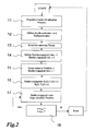
- a query scheme for this procedure is outlined in FIG. 2. This is just one possible example In another method, e.g. a target memory is provided become.
- the current position 8 is first projected onto a corresponding map.
- This step is characterized by reference number 11.
- the start and destination coordinates of the route are selected.
- a navigation device calculates a suitable route, which is indicated in the third step 13.
- the degree of scaling is parameterized. This step, identified by reference numeral 14, gives the possibility of choosing a maximum and a minimum degree of scaling, in the example shown the maximum degree of scaling to 1 and the minimum degree to 0.
- the current position becomes scaling degree 1, that is to say maximum degree of scaling.
- the change in scaling depends on the one hand on the respective x and y value on the projection and on the other hand on the time, provided the current position changes over time.
- a query is made as to whether the target point with the target coordinates x target and y target has already been reached. If this should be the case, the target point tracking and navigation are defined as complete, which is indicated in FIG. 2 by "end". The query is then reset to the starting point. If the target point query is negative, i.e. the target or the target point has not yet been reached, the maximum degree of scaling of the current position will continue to be updated. This is also indicated in Figure 2.
- the representation of the target can be omitted become.
- a selection of distinctive areas can also be defined that are only in the area of minimum resolution or Border areas are shown, such as rivers, forest areas Etc.
- Figure 3 shows three possible mapping rules to represent a relative Scale change depending on the relative distance to the current position.
- Data from one device for projecting navigation data with another Scaling can be represented as the remaining data of the projection, being the scaling between the different data is continuous and / or changed or changeable step by step within the projection is.
- the step size can in particular be set by the user himself be determined or is by corresponding functions in the projection specified or automatically set by this. Part of the data or projection is shown enlarged, whereas the the rest can be shown in normal format or even reduced.
Abstract
Description
Die Erfindung betrifft eine Vorrichtung zur Projektion von Navigationsdaten, insbesondere in einem Fahrzeug, wobei innerhalb der Projektion Bereiche mit unterschiedlicher Skalierung vorgesehen sind.The invention relates to a device for projecting navigation data, especially in a vehicle, with areas within the projection are provided with different scaling.
Derartige Vorrichtungen zur Projektion von Navigationsdaten sind im Stand der Technik bekannt. Hierbei wird zumeist eine Straßenkarte auf einer Anzeigeeinrichtung, insbesondere einem Display, in einem Fahrzeug dargestellt, wobei jeweils die aktuelle Position des Fahrzeugs in der Straßenkarte eingezeichnet ist. Außerdem wird zumeist ein eingebbarer Zielpunkt ebenfalls dargestellt sowie gegebenenfalls die Fahrtroute. Im Stand der Technik sind verschiedene Ansätze zur Darstellung solcher Navigationsdaten bekannt, wobei ein erster Ansatz diese ausschließlich mit einem festen Maßstab, also einer festen Skalierung, auf einer Anzeigeeinrichtung anzeigt. Die Auflösung dieser Darstellung kann manuell in fest eingestellten Rasterschritten vorgegeben werden und sich gegebenenfalls automatisch an die Umgebung anpassen. Beispielsweise ist im Bereich von Kreuzungen innerhalb von Städten eine Zoomfunktion möglich. Beispiele für derart gestalteter Vorrichtungen sind in der DE 43 36 513 A1, EP 0 678 731 A1 und EP 0 875 729 A3 offenbart. Aus der DE 43 36 513 A1 ist es bekannt, eine Karte mit einem Maßstab anzuzeigen, der die Momentan-Position eines Fahrzeugs und einen vorbestimmten Punkt einer Fahrtroute angibt, wenn sich das Fahrzeug nicht auf dieser bewegt. Hierbei wird der Maßstabsfaktor der Karte durch einen Maßstabsänderungsabschnitt festgelegt, um die Darstellung der Momentan-Position und des Anfangspunktes der Fahrtstreckenermittlung auf einem Bild zu ermöglichen.Such devices for the projection of navigation data are in the state known in the art. Usually a road map is shown on a display device, especially a display, shown in a vehicle, where the current position of the vehicle on the road map is drawn. In addition, an enterable target point is usually also shown as well as the route if necessary. In the state of the art different approaches for the representation of such navigation data are known, a first approach using this only on a fixed scale, that is, a fixed scale on a display device. The This display can be resolved manually in fixed grid steps be specified and, if necessary, automatically to the Adapt environment. For example, in the area of intersections a zoom function of cities is possible. Examples of such a design Devices are in DE 43 36 513 A1, EP 0 678 731 A1 and EP 0 875 729 A3. From DE 43 36 513 A1 it is known to use a card to display a scale representing the current position of a vehicle and indicates a predetermined point of a travel route when the vehicle is moving not moved on this. This is the scale factor of the map set by a scale change section to represent the Current position and the starting point of the route determination to enable an image.
Aus der EP 0 875 729 A3 ist es bekannt, eine Anzeigevorrichtung zum Anzeigen
eines Cursors in Verbindung mit einer Karteninformation und einer
Markierungsinformation vorzusehen, so dass der Cursor die Markierungsinformation
auf der Karte anzeigt. Dies geschieht durch Reduzierung des
Maßstabs der Karte, um die Markierung innerhalb des Anzeigebereichs darzustellen,
sofern festgestellt wird, dass die Markierung nicht innerhalb des
Anzeigebereichs liegt.
Gemäß der EP 0 678 731 A1 wird eine Vogelflugperspektive von verschiedenen
Sichtpunkten aus und mit unterschiedlichem Skalierungsbereich entsprechend
der Fahrzeuggeschwindigkeit oder entsprechend dem Abstand
der aktuellen Fahrzeugposition zu dem nächsten spezifizierten Verkehrspunkt
angegeben. Es werden also verschiedene Straßenkarten aus der Vogelflugperspektive
angezeigt, die von einem geeigneten Sichtpunkt aus und
in geeignetem Skalierungsmaßstab zu jeder Zeit entsprechend den Verkehrsbedingungen
des Fahrzeugs angezeigt werden können. Ein weiteres
Beispiel einer dreidimensionalen Darstellung in Vogelflugperspektive ist aus
der DE 195 44 921 A1 bekannt. Hierbei wird durch Variation des Grades der
Anzeige von Einzelheiten einer Straßenkarte ein Gefühl von Tiefe für den
Betrachter vermittelt. Dabei kann der Grad an Einzelheiten abnehmen, wenn
die angezeigte Position des Bildschirms bezüglich des Anzeigerahmens höher
gelegen ist.According to
Ein anderer Ansatz im Stand der Technik ist es, gleichzeitig einen Zoombereich, beispielsweise eine Kreuzung, und eine Übersichtskarte auf der gleichen Anzeigeeinrichtung, insbesondere einem Display, anzuzeigen. Die Auflösung der Darstellung kann dabei gegebenenfalls automatisch oder manuell variiert werden. Beispiele hierfür sind beispielsweise in der US 5,925,091, US 5,936,631 und US 5,699,255 zu finden. Gemäß der US 5,936,631 können entweder große Straßen in einer detaillierten Karte oder kleine Straße in einer großräumigen Karte angezeigt werden. Gemäß der US 5,925,091 ist lediglich die Anzeige der aktuell benutzten Straße in einer großräumigen Karte vorgesehen.Another approach in the prior art is to simultaneously use a zoom area, for example an intersection and an overview map on the same Display device, in particular a display. The If necessary, the display can be resolved automatically or manually can be varied. Examples of this are, for example, in the US 5,925,091, US 5,936,631 and US 5,699,255. According to the US 5,936,631 can either have large streets in a detailed map or small street can be shown in a large map. According to the US 5,925,091 is only the display of the currently used street in a large area Card provided.
Die Anzeige lediglich eines festen Maßstabes bzw. die Auflösung einer Darstellung in manuell vorgebbaren festen Rasterschritten mit gegebenenfalls automatischer Anpassung an die Umgebung weist den Nachteil auf, dass das Anzeigen einer detailreichen Ansicht, beispielsweise einer Kreuzung, nur ohne eine großräumige Ansicht der Umgebung möglich ist. Hierbei geht für den Benutzer die geographische Orientierung beispielsweise an Flüssen etc. verloren, nämlich Informationen darüber, in welcher Richtung er sich bewegt und in welcher Richtung bzw. wo sich das von ihm angesteuerte Ziel befindet. Der Nachteil des gleichzeitigen Anzeigens eines Zoombereichs und einer Übersichtskarte auf ein und derselben Anzeigeeinrichtung mit gegebenenfalls automatisch oder manuell betätigter Variation der Auflösung, wie in dem zweiten Ansatz offenbart, löst zwar das vorstehend genannte Problem, jedoch ergeben sich weitere Nachteile dadurch, dass gegebenenfalls Teile der Übersichtskarte durch den Zoombereich verdeckt werden. Außerdem ist lediglich eine geringe Auflösung möglich, insbesondere mit einer kleinen unleserlichen Schriftgröße, wodurch der Informationsgehalt einer solchen Darstellung für den Benutzer stark eingeschränkt ist.The display of only a fixed scale or the resolution of a representation in manually predefined fixed grid steps with if necessary automatic adaptation to the environment has the disadvantage that displaying a detailed view, such as an intersection, only without a large-scale view of the surroundings. Here goes for the user the geographic orientation, for example on rivers etc. lost, namely information about the direction in which it is moving and in which direction or where the destination he is heading is. The disadvantage of displaying a zoom area and one at the same time Overview map on one and the same display device with, if necessary automatically or manually operated variation of the resolution, as in the second approach, solves the above problem, however, further disadvantages result from the fact that parts, if appropriate the overview map are hidden by the zoom area. Besides, is only a low resolution possible, especially with a small illegible one Font size, which reduces the information content of such a representation is severely restricted for the user.
Der vorliegenden Erfindung liegt daher die Aufgabe zugrunde, eine Vorrichtung zur Projektion von Navigationsdaten vorzusehen, bei der die genannten Nachteile des Standes der Technik nicht mehr auftreten, also der Benutzer ein sehr hohes Maß an Informationsgehalt der dargestellten Karte entnehmen kann, sowohl im Nahbereich als auch im Fernbereich.The present invention is therefore based on the object of a device to provide for the projection of navigation data in which the aforementioned Disadvantages of the prior art no longer occur, ie the user take a very high level of information from the map shown can, both at close range and at a distance.
Die Aufgabe wird durch eine Vorrichtung zur Projektion von Navigationsdaten
nach dem Oberbegriff des Anspruchs 1 dadurch gelöst, dass die Skalierung
der Bereiche sich kontinuierlich und/oder schrittweise innerhalb der
Projektion ändert. Weiterbildungen der Erfindung sind in den abhängigen
Ansprüchen definiert. The task is accomplished by a device for projecting navigation data
solved according to the preamble of
Hierdurch wird vorteilhaft erreicht, dass ähnlich einer in verbreiterten Stadtplänen verwendeten hyperbolischen Projektion die Karten nicht mehr mit einem festen Maßstab dargestellt werden, sondern eine unterschiedliche Skalierung zwischen den einzelnen Bereichen, nämlich Nahbereich und Fernbereich, der Kartenprojektion möglich ist. Diese ändert sich über die Projektionsfläche hinweg derart, dass für den Betrachter ein optimaler Informationsgehalt gegeben ist, wobei insbesondere nicht durch einen Zoombereich Teile der Übersichtskarte verdeckt werden. Die momentan für den Benutzer relevanten Daten werden vorzugsweise vergrößert dargestellt, wobei dieser gleichzeitig einen Überblick über den Gesamtbereich der Umgebung, in der er sich befindet, erhält. Jeder Bereich der Projektion wird dabei dargestellt und nicht durch einen anderen verdeckt. Durch geeignete Wahl der Skalierungsvariation können ein Ausgangspunkt, die aktuelle Position und der angestrebte Zielpunkt in ein und derselben Projektion dargestellt werden.This advantageously achieves that similar to that in widened city maps hyperbolic projection no longer used the maps with one fixed scale, but a different scaling between the individual areas, namely short-range and long-range, the map projection is possible. This changes over the projection surface away in such a way that an optimal information content for the viewer is given, parts in particular not by a zoom area the overview map. The currently relevant for the user Data is preferably shown enlarged, whereby this at the same time an overview of the entire area of the environment in which he is located. Each area of the projection is shown and not covered by another. By a suitable choice of the scaling variation can be a starting point, the current position and the desired Target point can be shown in the same projection.
Vorzugsweise ist die Skalierung an die sich ändernde Position dynamisch anpassbar. Hierdurch entsteht gegenüber Faltplänen der große Vorteil, dass keine fest eingestellte Skalierung, wie bei diesen nur möglich, vorgesehen werden kann, sondern eine sich stetig ändernde dynamische Anpassung an die jeweils aktuelle Position vorgenommen werden kann. Ist also beispielsweise über einen langen Zeitraum hinweg eine kreuzungsfreie Strecke zu befahren, kann die Skalierung grob sein. Muss hingegen häufig die Fahrtrichtung geändert werden, z.B. in Innenstädten, wird eine feine Skalierung gewählt. Hierdurch ist jeweils eine optimale Anpassung der Skalierung an die aktuellen Bedingungen möglich, wobei der Informationsgehalt für den Betrachter maximal ist.The scaling to the changing position is preferably dynamic customizable. This has the great advantage over folding plans that no fixed scaling, as only possible with these, is provided but a constantly changing dynamic adaptation the current position can be made. So is for example over a long period of time without a crossing the scaling can be rough. However, the direction of travel must be frequent be changed, e.g. in city centers, is fine scaling selected. This is an optimal adjustment of the scaling to the current conditions possible, the information content for the viewer is maximum.
Bevorzugt weist zumindest ein Bereich eine feinere Skalierung auf als andere, diese umgebende Bereiche der Projektion. Besonders bevorzugt ist der Bereich mit der feinsten Skalierung ein Nahbereich, insbesondere die aktuelle Position. Die feinste Skalierung bedeutet hierbei ein Zoom z.B. der aktuellen Position bzw. des Nahbereichs um die aktuelle Position herum. Die Bereiche, die diesen Nahbereich umgeben, weisen eine gröbere Skalierung auf, können jedoch untereinander unterschiedlich skaliert sein. Beispielsweise kann der Bereich einer zu fahrenden Straße oder Route feiner skaliert sein als die Bereiche, die innerhalb der Projektion nicht anzufahren sind. Hierdurch ist für den Betrachter jeweils sofort auffällig, welcher Bereich bzw. welche Bereiche für ihn interessant sind und welche lediglich der groben Orientierung dienen. Es reicht somit ein kurzer Blick auf die Projektion, um sowohl die aktuelle Position als auch die weitere Fahrtroute eindeutig und schnell erkennen zu können, was gerade bei Verwendung in einem Kraftfahrzeug besonders vorteilhaft ist, da der Fahrer des Fahrzeugs möglichst nicht von den Straßenverhältnissen abgelenkt wird.At least one area preferably has a finer scaling than others, these surrounding areas of projection. The is particularly preferred Area with the finest scaling is a close-up area, especially the current one Position. The finest scaling means a zoom e.g. the current Position or the close range around the current position. The areas, that surround this near area have a coarser scale, can, however, be scaled differently from one another. For example the area of a road or route to be driven can be more finely scaled than the areas that cannot be reached within the projection. hereby is immediately noticeable to the viewer, which area or which Areas are of interest to him and which are only of rough orientation serve. A quick glance at the projection is enough to both the current position as well as the further route clearly and quickly to be able to recognize what is currently being used in a motor vehicle is particularly advantageous since the driver of the vehicle preferably does not move from is distracted from the road conditions.
Vorzugsweise ist eine lineare und/oder nicht lineare Änderung der Skalierung um zumindest einen Bereich, insbesondere den Nahbereich, herum vorgesehen. Es ist somit eine neue Abbildungsvorschrift gebildet, bei der eine Verzerrung der Projektion auftritt. Die Verzerrung kann innerhalb der Projektion sowohl linear als auch nichtlinear sein je nach dem, welche Darstellung für den Betrachter den optimalen Informationsgehalt enthält. Besonders bevorzugt ist es hierbei, wenn die Änderung der Skalierung um zumindest einen Bereich, insbesondere den Nahbereich, herum sich zirkular erstreckt. Da eine unterschiedliche Skalierung automatisch zu einer Verzerrung des Bildes führt, kann es je nach Anwendungsfall vorteilhaft sein, diese Verzerrung sich zirkular oder beispielsweise ellipsenförmig um den aktuellen Positionsbereich herum erstrecken zu lassen, um dem Betrachter ein schnell und einfach erfassbares Bild zur Orientierung zu geben. Es kann alternativ jedoch auch eine nicht zirkulare Erstreckung der unterschiedlichen Skalierung vorgesehen werden, z.B. wenn die Skalierung in einer Richtung feiner sein soll als in den anderen.A linear and / or non-linear change in the scaling is preferred around at least one area, in particular the near area. A new mapping rule is thus formed, in which one Distortion of the projection occurs. The distortion can be within the projection be both linear and nonlinear depending on which representation contains the optimal information content for the viewer. Particularly preferred It is here when the scaling is changed by at least one Area, in particular the near area, extends circularly. There a different scaling automatically leads to a distortion of the image leads, it may be advantageous depending on the application, this distortion circular or elliptical, for example, around the current position range stretch around to give the viewer a quick and easy to grasp To give a picture for orientation. Alternatively, it can a non-circular extension of the different scaling is provided e.g. if the scaling should be finer in one direction than in the other.
Vorzugsweise ist der Grad der Veränderung der Skalierung parametrisierbar und/oder einstellbar. Besonders bevorzugt ist der Grad der Veränderung zwischen 0 und 1 wählbar, insbesondere gibt 0 eine nicht vorhandene Veränderung und 1 eine maximale Veränderung an. Unter der Parametrisierung wird somit insbesondere eine Zuordnung des Grades der Veränderung der Skalierung zu Zahlenwerten verstanden, also beispielsweise 0 und 1, um ein Maximum und ein Minimum sowie Zwischenschritte angeben zu können. The degree of change in the scaling can preferably be parameterized and / or adjustable. The degree of change is particularly preferred selectable between 0 and 1, in particular 0 gives a non-existent change and 1 indicates a maximum change. Under the parameterization an assignment of the degree of change of the Understand scaling to numerical values, for example 0 and 1, by one To be able to specify maximum and minimum as well as intermediate steps.
Durch eine vorzugsweise vorhandene Einstellmöglichkeit des Grades der Skalierungsveränderung können Maximum und Minimum verschoben werden, somit auch Zwischenschritte, wodurch durch den Benutzer ein für den jeweiligen Anwendungsfall optimaler Skalierungsbereich eingestellt werden kann. Dieser wird vorzugsweise vor Fahrtantritt eingestellt, kann jedoch auch bei Bedarf mühelos währenddessen verändert werden. Beispielsweise kann dies bei Durchfahren größerer Städte sinnvoll werden, um beispielsweise Einbahnstraßen oder dergleichen schneller erkennen zu können. Auch bei Kopplung mit einem Stauwarnsystem kann die Veränderung des Grades der Skalierung während der Fahrt sinnvoll sein, um Ausweichstrecken besser erkennen zu können. Die Einstellung des Grades der Veränderung der Skalierung kann auch automatisch erfolgen, beispielsweise bei Kopplung mit einem Stauwarnsystem oder ähnlichem.Through a preferably available setting option for the degree of Scaling changes can be shifted maximum and minimum, thus also intermediate steps, which means that the user can use the optimal scaling range can be set for each application can. This is preferably set before the start of the journey, but can also can be changed effortlessly if necessary. For example this can be useful when driving through larger cities, for example To recognize one-way streets or the like faster. Also at Coupling with a traffic jam warning system can change the degree of Scaling may be useful while driving to make alternative routes better to be able to recognize. The setting of the degree of scaling change can also be done automatically, for example when paired with a traffic jam warning system or the like.
Bevorzugt ist eine wählbare Maximalveränderung der Skalierung im Zentrum der Projektion vorgesehen oder vorsehbar. Hierbei ist also eine Maximalauflösung im Zentrum einer solchen Projektion möglich, die vom Benutzer vorgegeben werden kann. Das Zentrum bildet dabei beispielsweise die aktuelle Fahrzeugposition. Der Benutzer braucht dann nicht lange auf der Projektion nach der aktuellen Fahrzeugposition zu suchen, sondern bekommt diese jeweils im Bereich von deren Zentrum angezeigt. Alternativ ist es natürlich auch möglich, die aktuelle Fahrzeugposition über die Karte wandern zu lassen, wobei der Betrachter diese an der Maximalauflösung, also der Maximalveränderung der Skalierung der Projektion schnell erkennt. Vorzugsweise ist die Einstellung hierbei von dem Betrachter abhängig und kann personenspezifisch unterschiedlich mit ein und derselben Vorrichtung vorgenommen werden.A selectable maximum change in the scaling in the center is preferred projected or foreseeable. So here is a maximum resolution possible in the center of such a projection, specified by the user can be. The center, for example, is the current one Vehicle position. The user does not need long on the projection to search for the current vehicle position, but get it displayed in the area of their center. Alternatively, it is natural also possible to let the current vehicle position move on the map, with the viewer seeing this at the maximum resolution, ie the maximum change quickly recognizes the scaling of the projection. Preferably the setting depends on the viewer and can be person-specific be made differently with one and the same device.
Vorzugsweise ist eine Maßstabsanzeigeeinrichtung, insbesondere ein Maßstabsbalken, Maßstabskreuz oder eine andere geeignete Maßstabsanzeigeeinrichtung, ausgehend von einem Bereich in der Projektion anzeigbar. Besonders bevorzugt ist die Maßstabsanzeigeeinrichtung von dem Bereich mit der maximalen Veränderung, insbesondere dem Zentrum der Projektion, aus anzeigbar. Durch das Einblenden einer solchen verzerrten Maßstabsanzeigeeinrichtung, insbesondere eines Maßstabsbalkens oder -kreuzes, können Entfernungen zwischen der aktuellen Position und dem Ziel besser abgeschätzt werden. In einer bevorzugten Ausführungsform wird die Entfernung ebenfalls auf der Projektion angezeigt oder kann auf Anforderung angezeigt werden.A scale display device, in particular a scale bar, is preferably Scale cross or other suitable scale display device, Displayable from an area in the projection. Especially the scale display device is preferred from the area with the maximum change, especially the center of the projection displayable. By fading in such a distorted scale display device, especially a scale bar or cross Distances better estimated between the current position and the target become. In a preferred embodiment, the removal also displayed on the projection or can be displayed on request become.
Zur näheren Erläuterung der Erfindung wird im folgenden ein Ausführungsbeispiel anhand der Zeichnungen näher beschrieben. Diese zeigen in:
Figur 1- eine Draufsicht auf eine erfindungsgemäße Vorrichtung zur Projektion von Navigationsdaten, auf der eine Landkarte projiziert ist,
Figur 2- ein Ablaufschema für den Vorgang der Fahrtroutenverfolgung und Darstellung von Navigationsdaten auf einer Projektion gemäß Figur 1, und
Figur 3- eine Darstellung dreier Abbildungsvorschriften zur Projektion der Navigationsdaten.
- Figure 1
- 1 shows a plan view of a device according to the invention for projecting navigation data, on which a map is projected,
- Figure 2
- a flow chart for the process of driving route tracking and display of navigation data on a projection according to Figure 1, and
- Figure 3
- a representation of three mapping rules for the projection of the navigation data.
In Figur 1 ist eine erfindungsgemäße Vorrichtung 1 zur Projektion von Navigationsdaten
gezeigt, auf der eine Landkarte projiziert ist. Die Landkarte als
Projektion 2 ist in unterschiedliche Bereiche 3, 4, 5 aufgeteilt. Der Bereich 3
ist dabei der Nahbereich, der Bereich 4 der Zwischenbereich und der Bereich
5 der Fernbereich. Jeder dieser Bereiche weist unterschiedliche Skalierungen
auf, die sich innerhalb der Bereiche ebenfalls ändern. Der Nahbereich 3
weist eine feinere Skalierung bzw. einen geringeren Maßstab auf als der
Zwischenbereich 4 und dieser weist wiederum eine feinere Skalierung auf als
der Fernbereich 5. Die Skalierung kann auch an zwei Maßstabsbalken 6, 7,
die in x- und y-Richtung liegen, abgelesen werden. Innerhalb des Nahbereichs
ist die aktuelle Position beispielsweise eines Fahrzeugs mit den Bezugszeichen
8 und einem Stern markiert. Die feine Skalierung des Nahbereichs
ist im Bereich der aktuellen Position 8 am feinsten und wird in Richtung
zu dem den Nahbereich umgebenden Zwischenbereich 4 grober, also
der Maßstab größer.1 shows a
Mit der Bewegung beispielsweise des Fahrzeugs, also der Veränderung der
aktuellen Position 8, wandert die Feinstskalierung mit dieser Position mit, so
dass auch der Nahbereich 3 und der Zwischenbereich 4 über die Projektion
2 hinweg wandern. Hierbei kann entweder eine Verschiebung über die angezeigte
Projektion hinweg erfolgen, so dass ein Bild entsteht, das ähnlich einer
Lupe über die Fahrtroute 9, die von einem Anfangspunkt A zu einem
Zielpunkt Z führt, verschoben wird. Die Fahrtroute 9 ist in Figur 1 punktiert
dargestellt.With the movement of the vehicle, for example, i.e. the change in the
Die sich durch die unterschiedlichen Skalierungen ergebende Verzerrung
ändert sich zunächst elliptisch um die aktuelle Position 8 herum. Aus diesem
Grunde ist die Abgrenzung zwischen Nahbereich und Zwischenbereich als
Ellipse dargestellt. Die Abgrenzung zwischen Zwischenbereich und Fernbereich
ist hingegen als Rechteck ausgebildet. In einer anderen Ausführungsform
können jedoch auch unregelmäßige Figuren als Begrenzungen der Bereiche
vorgesehen werden, sofern sich dies beispielsweise bei dem jeweiligen
Gelände als vorteilhafter, da besser darstellbar und schneller erfassbar,
erweist.The distortion resulting from the different scaling
first changes elliptically around the
Der Skalierungsgrad um die aktuelle Position 8 herum kann von dem Benutzer
vorgegeben werden. Hierbei wählt er aus einer vorgegebenen oder vorgebbaren
Auswahl an Skalierungsmöglichkeiten eine für ihn passende aus
und bestimmt hieraus den maximalen Grad der Veränderung der Skalierung,
also die maximale Auflösung der Projektion bzw. Karte im Bereich der aktuellen
Position. Außerdem kann er den minimalen Grad der Veränderung der
Skalierung wählen, also den minimalen Grad an Verzerrung und zugleich die
Minimalauflösung, die im Fernbereich vorliegen soll. Ein Abfrageschema für
dieses Vorgehen ist in Figur 2 skizziert. Dies stellt nur ein mögliches Beispiel
dar. Bei einem anderen Verfahren kann z.B. ein Zielspeicher vorgesehen
werden. The degree of scaling around the
In der dort skizzierten Ausführungsform wird, ausgehend von der Initiierung
eines Programmstarts, insbesondere dem Einschalten der Vorrichtung 1
mittels eines Ein-/ Ausschalters 10, zunächst die aktuelle Position 8 auf einer
entsprechenden Karte projiziert. Dieser Schritt ist mit dem Bezugszeichen 11
charakterisiert. In einem zweiten Schritt 12 werden die Start- und Zielkoordinaten
der Fahrtroute gewählt. Hieraus errechnet eine Navigationseinrichtung
eine geeignete Fahrtroute, was mit dem dritten Schritt 13 angedeutet ist. In
einem vierten Schritt wird die Parametrisierung des Skalierungsgrades vorgenommen.
Dieser mit dem Bezugszeichen 14 charakterisierte Schritt gibt
die Möglichkeit, einen maximalen und einen minimaleren Skalierungsgrad zu
wählen, in dem dargestellten Beispiel den maximalen Skalierungsgrad zu 1
und den minimalen zu 0. In einem fünften Schritt 15 wird die aktuelle Position
dem Skalierungsgrad 1, also dem maximalen Skalierungsgrad, zugeordnet.
In dem sechsten Schritt 16 werden die übrigen Punkte der Projektion einzelnen
Skalierungsgraden zugeordnet nach den Formeln
In einem siebten Schritt 17 ist vorgesehen, dass der maximale Skalierungsgrad
der aktuellen Position folgt, so dass diese stets mit der maximal möglichen
bzw. eingestellten maximalen Auflösung dargestellt wird, um dem Beobachter
eine möglichst optimale Ablesbarkeit zu ermöglichen. In einem
achten Schritt 18 wird abgefragt, ob bereits der Zielpunkt mit den Zielkoordinaten
xZiel und yZiel erreicht ist. Sofern dies der Fall sein sollte, wird die Zielpunktverfolgung
und Navigation als abgeschlossen definiert, was in Figur 2
durch "Ende" angedeutet ist. Nachfolgend wird die Abfrage wieder auf den
Startpunkt zurückgesetzt. Sofern die Zielpunktabfrage negativ verläuft, also
das Ziel bzw. der Zielpunkt noch nicht erreicht ist, wird weiterhin der maximale
Skalierungsgrad der aktuellen Position nachgeführt. Dies ist ebenfalls
in Figur 2 angedeutet.In a
In einer alternativen Ausführungsform kann die Darstellung des Ziels weggelassen werden. Außerdem kann eine Auswahl markanter Gebiete definiert werden, die ausschließlich in dem Bereich minimaler Auflösung bzw. den Randbereichen dargestellt werden, wie beispielsweise Flüsse, Waldgebiete etc.In an alternative embodiment, the representation of the target can be omitted become. A selection of distinctive areas can also be defined that are only in the area of minimum resolution or Border areas are shown, such as rivers, forest areas Etc.
Figur 3 zeigt drei mögliche Abbildungsvorschriften zur Darstellung einer relativen Maßstabsänderung in Abhängigkeit von der relativen Entfernung bezogen auf die gegenwärtige Position. Gezeigt sind dabei eine exponentielle, eine lineare und eine quadratische Maßstabsänderung.Figure 3 shows three possible mapping rules to represent a relative Scale change depending on the relative distance to the current position. An exponential, a linear and a square scale change.
Neben den im vorstehenden beschrieben Ausführungsformen können noch weitere gebildet werden, bei denen jeweils aktuell für den Benutzer relevante Daten einer Vorrichtung zur Projektion von Navigationsdaten mit einer anderen Skalierung dargestellt werden, als die übrigen Daten der Projektion, wobei die Skalierung zwischen den unterschiedlichen Daten jeweils kontinuierlich und/oder schrittweise innerhalb der Projektion verändert oder veränderlich ist. Die Schrittweite kann dabei insbesondere durch den Benutzer selbst bestimmt werden oder ist durch entsprechende Funktionen in der Projektion vorgegeben bzw. wird durch diese automatisch eingestellt. Ein Teil der Daten bzw. Projektion wird dabei jeweils vergrößert dargestellt, wohingegen die übrigen im Normalformat oder sogar verkleinert dargestellt sein können. In addition to the embodiments described above, other more are formed, each of which is currently relevant to the user Data from one device for projecting navigation data with another Scaling can be represented as the remaining data of the projection, being the scaling between the different data is continuous and / or changed or changeable step by step within the projection is. The step size can in particular be set by the user himself be determined or is by corresponding functions in the projection specified or automatically set by this. Part of the data or projection is shown enlarged, whereas the the rest can be shown in normal format or even reduced.
- 11
- Vorrichtungcontraption
- 22
- Projektionprojection
- 33
- Nahbereichclose range
- 44
- Zwischenbereichintermediate area
- 55
- Fernbereichremote area
- 66
- Maßstabsbalkenscale bars
- 77
- Maßstabsbalkenscale bars
- 88th
- aktuelle Positionactual position
- 99
- Fahrtrouteroute
- 1010
- Ein-/AusschalterOn / off switch
- 1111
- erster Schrittfirst step
- 1212
- zweiter Schrittsecond step
- 1313
- dritter SchrittThird step
- 1414
- vierter Schrittfourth step
- 1515
- fünfter Schrittfifth step
- 1616
- sechster Schrittsixth step
- 1717
- siebter Schrittseventh step
- 1818
- achter Schritteighth step
- AA
- Anfangspunktstarting point
- ZZ
- ZielpunktEndpoint
Claims (11)
dadurch gekennzeichnet, dass
die Skalierung der Bereiche (3, 4, 5) sich kontinuierlich und/oder schrittweise innerhalb der Projektion (2) ändert.Device (1) for projecting navigation data, in particular in a vehicle, areas (3, 4, 5) with different scales being provided within the projection (2),
characterized in that
the scaling of the areas (3, 4, 5) changes continuously and / or step by step within the projection (2).
dadurch gekennzeichnet, dass
die Skalierung an die sich ändernde Position (8) dynamisch anpassbar ist.Device (1) according to claim 1,
characterized in that
the scaling to the changing position (8) is dynamically adaptable.
dadurch gekennzeichnet, dass
zumindest ein Bereich (3) eine feinere Skalierung aufweist als andere diesen umgebende Bereiche (4, 5) der Projektion (2).Device (1) according to claim 1 or 2,
characterized in that
at least one area (3) has a finer scaling than other areas (4, 5) of the projection (2) surrounding it.
dadurch gekennzeichnet, dass
der Bereich (3) mit der feinsten Skalierung ein Nahbereich, insbesondere die aktuelle Position (8) ist.Device (1) according to claim 3,
characterized in that
the area (3) with the finest scaling is a near area, in particular the current position (8).
dadurch gekennzeichnet, dass
eine lineare und/oder nichtlineare Änderung der Skalierung um zumindest einen Bereich (3), insbesondere den Nahbereich, herum vorgesehen ist.Device (1) according to one of the preceding claims,
characterized in that
a linear and / or non-linear change in the scaling around at least one area (3), in particular the near area, is provided.
dadurch gekennzeichnet, dass
die Änderung der Skalierung um zumindest einen Bereich (3), insbesondere den Nahbereich, herum sich zirkular erstreckt.Device (1) according to one of the preceding claims,
characterized in that
the change in the scaling extends circularly around at least one area (3), in particular the near area.
dadurch gekennzeichnet, dass
der Grad der Veränderung der Skalierung parametrisierbar und/oder einstellbar ist.Device (1) according to one of the preceding claims,
characterized in that
the degree of change in scaling is parameterizable and / or adjustable.
dadurch gekennzeichnet, dass
der Grad der Veränderung zwischen 0 und 1 wählbar ist, insbesondere 0 eine nicht vorhandene Veränderung und 1 eine maximale Veränderung angibt.Device (1) according to claim 7,
characterized in that
the degree of change can be selected between 0 and 1, in particular 0 indicates a non-existing change and 1 a maximum change.
dadurch gekennzeichnet, dass
eine wählbare Maximalveränderung der Skalierung im Zentrum der Projektion (2) vorgesehen oder vorsehbar ist.Device (1) according to one of the preceding claims,
characterized in that
a selectable maximum change in the scaling in the center of the projection (2) is provided or can be provided.
dadurch gekennzeichnet, dass
eine Maßstabsanzeigeeinrichtung (6, 7), insbesondere ein Maßstabsbalken, Maßstabskreuz oder eine andere geeignete Maßstabsanzeigeeinrichtung, ausgehend von einem Bereich (3) in der Projektion (2) anzeigbar ist.Device (1) according to one of the preceding claims,
characterized in that
a scale display device (6, 7), in particular a scale bar, scale cross or another suitable scale display device, can be displayed starting from an area (3) in the projection (2).
dadurch gekennzeichnet, dass
die Maßstabsanzeigeeinrichtung (6, 7) von dem Bereich (3) mit der maximalen Veränderung, insbesondere dem Zentrum der Projektion (2), aus anzeigbar ist.Device (1) according to claim 10,
characterized in that
the scale display device (6, 7) can be displayed from the area (3) with the maximum change, in particular the center of the projection (2).
Applications Claiming Priority (2)
| Application Number | Priority Date | Filing Date | Title |
|---|---|---|---|
| DE2001141507 DE10141507C2 (en) | 2001-08-24 | 2001-08-24 | Device for projecting navigation data |
| DE10141507 | 2001-08-24 |
Publications (2)
| Publication Number | Publication Date |
|---|---|
| EP1288627A2 true EP1288627A2 (en) | 2003-03-05 |
| EP1288627A3 EP1288627A3 (en) | 2006-08-23 |
Family
ID=7696479
Family Applications (1)
| Application Number | Title | Priority Date | Filing Date |
|---|---|---|---|
| EP02018439A Withdrawn EP1288627A3 (en) | 2001-08-24 | 2002-08-16 | Navigational data projection device |
Country Status (2)
| Country | Link |
|---|---|
| EP (1) | EP1288627A3 (en) |
| DE (1) | DE10141507C2 (en) |
Cited By (15)
| Publication number | Priority date | Publication date | Assignee | Title |
|---|---|---|---|---|
| EP1643214A2 (en) * | 2004-10-01 | 2006-04-05 | Bose Corporation | Mobile navigation system and method for displaying information of such a system |
| WO2006117021A1 (en) * | 2005-04-29 | 2006-11-09 | Volkswagen Ag | Method for controlling the display of a geographic map in a vehicle and display device therefor |
| WO2007110690A1 (en) * | 2006-03-27 | 2007-10-04 | Sony Ericsson Mobile Communications Ab | Display based on location information |
| EP1901038A1 (en) * | 2006-09-12 | 2008-03-19 | Alpine Electronics, Inc. | Map display system and navigation system |
| CN1841022B (en) * | 2005-03-30 | 2011-09-21 | 株式会社电装 | Navigation system and program for the same |
| EP2700906A1 (en) * | 2012-08-23 | 2014-02-26 | Harman Becker Automotive Systems GmbH | Method for displaying map views and a map viewing system |
| CN103971587A (en) * | 2013-02-05 | 2014-08-06 | 昆达电脑科技(昆山)有限公司 | Gradient map for navigation, gradient map generation method and navigation device |
| EP3111403A4 (en) * | 2014-02-26 | 2017-11-01 | Blazer and Flip Flops Inc. D/B/A The Experience Engine Inc. | Live branded dynamic mapping |
| US10028091B2 (en) | 2015-04-23 | 2018-07-17 | Blazer and Flip Flops, Inc. | Targeted venue message distribution |
| US10129728B2 (en) | 2015-12-07 | 2018-11-13 | Blazer and Flip Flops, Inc. | Wearable device |
| US10149103B2 (en) | 2015-05-01 | 2018-12-04 | Blazer and Flip Flops, Inc. | Map based beacon management |
| US10198717B2 (en) | 2014-02-26 | 2019-02-05 | Blazer and Flip Flops, Inc. | Parental controls |
| US10210542B2 (en) | 2014-02-26 | 2019-02-19 | Blazer and Flip Flops, Inc. | Venue guest device message prioritization |
| CN114072865A (en) * | 2019-04-18 | 2022-02-18 | 索尼半导体解决方案公司 | Information processing apparatus, mobile apparatus, method, and program |
| US11526916B2 (en) | 2015-04-28 | 2022-12-13 | Blazer and Flip Flops, Inc. | Intelligent prediction of queue wait times |
Families Citing this family (1)
| Publication number | Priority date | Publication date | Assignee | Title |
|---|---|---|---|---|
| DE102015005687A1 (en) * | 2015-05-06 | 2016-11-10 | Iav Gmbh Ingenieurgesellschaft Auto Und Verkehr | Continuous map projection with variable detail display |
Citations (5)
| Publication number | Priority date | Publication date | Assignee | Title |
|---|---|---|---|---|
| JPH0261690A (en) * | 1988-08-26 | 1990-03-01 | Daihatsu Motor Co Ltd | Display method for map for navigation |
| JPH06273184A (en) * | 1993-03-23 | 1994-09-30 | Nissan Motor Co Ltd | Displaying method for route guiding apparatus of vehicle |
| DE19537255A1 (en) * | 1994-10-15 | 1996-04-18 | Volkswagen Ag | Navigation appts. for driving motor vehicle to target position |
| EP0793074A1 (en) * | 1996-03-02 | 1997-09-03 | Philips Patentverwaltung GmbH | Method and device for displaying a map |
| US5699255A (en) * | 1995-10-18 | 1997-12-16 | Trimble Navigation Limited | Map transmission for in-vehicle navigation system with dynamic scale/detail adjustment |
Family Cites Families (8)
| Publication number | Priority date | Publication date | Assignee | Title |
|---|---|---|---|---|
| JPH0261590A (en) * | 1988-08-26 | 1990-03-01 | Seiko Epson Corp | Leg of dial for timepiece and welding thereof |
| DE4121095B4 (en) * | 1991-06-26 | 2004-09-16 | Robert Bosch Gmbh | Process for displaying maps on a computer-controlled screen |
| JPH06137882A (en) * | 1992-10-28 | 1994-05-20 | Toyota Motor Corp | Route guiding device for vehicle |
| DE69510493T2 (en) * | 1994-04-15 | 1999-10-28 | Nissan Motor | Vehicle navigation system |
| US5742924A (en) * | 1994-12-02 | 1998-04-21 | Nissan Motor Co., Ltd. | Apparatus and method for navigating mobile body using road map displayed in form of bird's eye view |
| JP3781795B2 (en) * | 1995-01-20 | 2006-05-31 | 三菱電機株式会社 | Mobile navigation device |
| JPH08339162A (en) * | 1995-06-12 | 1996-12-24 | Alpine Electron Inc | Map plotting method |
| JP3492145B2 (en) * | 1997-04-28 | 2004-02-03 | パイオニア株式会社 | Map display control method and device, and recording medium recording map display control program |
-
2001
- 2001-08-24 DE DE2001141507 patent/DE10141507C2/en not_active Expired - Lifetime
-
2002
- 2002-08-16 EP EP02018439A patent/EP1288627A3/en not_active Withdrawn
Patent Citations (5)
| Publication number | Priority date | Publication date | Assignee | Title |
|---|---|---|---|---|
| JPH0261690A (en) * | 1988-08-26 | 1990-03-01 | Daihatsu Motor Co Ltd | Display method for map for navigation |
| JPH06273184A (en) * | 1993-03-23 | 1994-09-30 | Nissan Motor Co Ltd | Displaying method for route guiding apparatus of vehicle |
| DE19537255A1 (en) * | 1994-10-15 | 1996-04-18 | Volkswagen Ag | Navigation appts. for driving motor vehicle to target position |
| US5699255A (en) * | 1995-10-18 | 1997-12-16 | Trimble Navigation Limited | Map transmission for in-vehicle navigation system with dynamic scale/detail adjustment |
| EP0793074A1 (en) * | 1996-03-02 | 1997-09-03 | Philips Patentverwaltung GmbH | Method and device for displaying a map |
Non-Patent Citations (2)
| Title |
|---|
| PATENT ABSTRACTS OF JAPAN Bd. 014, Nr. 240 (P-1051), 22. Mai 1990 (1990-05-22) & JP 02 061690 A (DAIHATSU MOTOR CO LTD), 1. März 1990 (1990-03-01) * |
| PATENT ABSTRACTS OF JAPAN Bd. 018, Nr. 685 (P-1848), 22. Dezember 1994 (1994-12-22) & JP 06 273184 A (NISSAN MOTOR CO LTD), 30. September 1994 (1994-09-30) * |
Cited By (20)
| Publication number | Priority date | Publication date | Assignee | Title |
|---|---|---|---|---|
| EP1643214A2 (en) * | 2004-10-01 | 2006-04-05 | Bose Corporation | Mobile navigation system and method for displaying information of such a system |
| EP1643214A3 (en) * | 2004-10-01 | 2006-12-27 | Bose Corporation | Mobile navigation system and method for displaying information of such a system |
| US7430473B2 (en) | 2004-10-01 | 2008-09-30 | Bose Corporation | Vehicle navigation display |
| CN1841022B (en) * | 2005-03-30 | 2011-09-21 | 株式会社电装 | Navigation system and program for the same |
| WO2006117021A1 (en) * | 2005-04-29 | 2006-11-09 | Volkswagen Ag | Method for controlling the display of a geographic map in a vehicle and display device therefor |
| US8095307B2 (en) | 2005-04-29 | 2012-01-10 | Volkswagen Ag | Method for controlling the display of a geographical map in a vehicle and display apparatus for that purpose |
| WO2007110690A1 (en) * | 2006-03-27 | 2007-10-04 | Sony Ericsson Mobile Communications Ab | Display based on location information |
| US7548814B2 (en) | 2006-03-27 | 2009-06-16 | Sony Ericsson Mobile Communications Ab | Display based on location information |
| EP1901038A1 (en) * | 2006-09-12 | 2008-03-19 | Alpine Electronics, Inc. | Map display system and navigation system |
| EP2700906A1 (en) * | 2012-08-23 | 2014-02-26 | Harman Becker Automotive Systems GmbH | Method for displaying map views and a map viewing system |
| CN103971587A (en) * | 2013-02-05 | 2014-08-06 | 昆达电脑科技(昆山)有限公司 | Gradient map for navigation, gradient map generation method and navigation device |
| EP3111403A4 (en) * | 2014-02-26 | 2017-11-01 | Blazer and Flip Flops Inc. D/B/A The Experience Engine Inc. | Live branded dynamic mapping |
| US10198717B2 (en) | 2014-02-26 | 2019-02-05 | Blazer and Flip Flops, Inc. | Parental controls |
| US10210542B2 (en) | 2014-02-26 | 2019-02-19 | Blazer and Flip Flops, Inc. | Venue guest device message prioritization |
| US10028091B2 (en) | 2015-04-23 | 2018-07-17 | Blazer and Flip Flops, Inc. | Targeted venue message distribution |
| US10299070B2 (en) | 2015-04-23 | 2019-05-21 | Blazer and Flip Flops, Inc. | Targeted venue message distribution |
| US11526916B2 (en) | 2015-04-28 | 2022-12-13 | Blazer and Flip Flops, Inc. | Intelligent prediction of queue wait times |
| US10149103B2 (en) | 2015-05-01 | 2018-12-04 | Blazer and Flip Flops, Inc. | Map based beacon management |
| US10129728B2 (en) | 2015-12-07 | 2018-11-13 | Blazer and Flip Flops, Inc. | Wearable device |
| CN114072865A (en) * | 2019-04-18 | 2022-02-18 | 索尼半导体解决方案公司 | Information processing apparatus, mobile apparatus, method, and program |
Also Published As
| Publication number | Publication date |
|---|---|
| DE10141507A1 (en) | 2003-03-13 |
| EP1288627A3 (en) | 2006-08-23 |
| DE10141507C2 (en) | 2003-06-18 |
Similar Documents
| Publication | Publication Date | Title |
|---|---|---|
| EP2026038B1 (en) | Method for changing the scale of a map representation in a navigation device | |
| DE3842179C2 (en) | ||
| EP1877731B1 (en) | Method for controlling the display of a geographic map in a vehicle and display device therefor | |
| DE69928387T2 (en) | THREE-DIMENSIONAL ROAD GUIDANCE INDICATOR FOR A VEHICLE NAVIGATION SYSTEM | |
| DE112004001405B4 (en) | Map display method | |
| DE69531188T2 (en) | navigation device | |
| DE69633421T2 (en) | Navigation display with bird's-eye view | |
| DE69434693T2 (en) | Vehicle guidance device and method using a display unit | |
| DE69535717T2 (en) | Roadmap display control device for a motor vehicle | |
| EP1288627A2 (en) | Navigational data projection device | |
| DE112004001569T5 (en) | In-vehicle information terminal | |
| EP0942403B1 (en) | Method and device for representation of information for a navigational apparatus | |
| DE4219326A1 (en) | Traffic information display system - contains map store with street start and end points and coordinates with straight lines inserted between end points for display | |
| DE19636056A1 (en) | navigation device | |
| DE10023160A1 (en) | Map display device e.g. for vehicle navigation system has three-dimensional display of buildings and streets on which route guidance line is superimposed | |
| DE60132946T2 (en) | navigation system | |
| EP3365632B1 (en) | Method for visually displaying the positions of selected destinations in maps in an altered manner | |
| DE4405771C2 (en) | Navigation system with a route determination method for quickly and precisely determining a desired route | |
| EP1957939B1 (en) | Device and method for outputting routing information of a navigation system | |
| DE102008061981A1 (en) | navigation device | |
| DE19738764A1 (en) | Graphical display in motor vehicle for road map | |
| DE10313223A1 (en) | Navigation device for route guidance of a motor vehicle | |
| EP1890112B1 (en) | Method for displaying object information and navigation system therefor | |
| DE19839798A1 (en) | Motor vehicle navigation system | |
| DE19839204A1 (en) | Map display arrangement for vehicle navigation system |
Legal Events
| Date | Code | Title | Description |
|---|---|---|---|
| PUAI | Public reference made under article 153(3) epc to a published international application that has entered the european phase |
Free format text: ORIGINAL CODE: 0009012 |
|
| AK | Designated contracting states |
Kind code of ref document: A2 Designated state(s): AT BE BG CH CY CZ DE DK EE ES FI FR GB GR IE IT LI LU MC NL PT SE SK TR Designated state(s): AT BE BG CH CY CZ DE DK EE ES FI FR GB GR IE IT LI LU MC NL PT SE SK TR |
|
| AX | Request for extension of the european patent |
Extension state: AL LT LV MK RO SI |
|
| PUAL | Search report despatched |
Free format text: ORIGINAL CODE: 0009013 |
|
| AK | Designated contracting states |
Kind code of ref document: A3 Designated state(s): AT BE BG CH CY CZ DE DK EE ES FI FR GB GR IE IT LI LU MC NL PT SE SK TR |
|
| AX | Request for extension of the european patent |
Extension state: AL LT LV MK RO SI |
|
| STAA | Information on the status of an ep patent application or granted ep patent |
Free format text: STATUS: THE APPLICATION HAS BEEN WITHDRAWN |
|
| 18W | Application withdrawn |
Effective date: 20060829 |