EP1251334A2 - Geographic database including data indicating wireless coverage and method and system for use thereof - Google Patents
Geographic database including data indicating wireless coverage and method and system for use thereof Download PDFInfo
- Publication number
- EP1251334A2 EP1251334A2 EP02252659A EP02252659A EP1251334A2 EP 1251334 A2 EP1251334 A2 EP 1251334A2 EP 02252659 A EP02252659 A EP 02252659A EP 02252659 A EP02252659 A EP 02252659A EP 1251334 A2 EP1251334 A2 EP 1251334A2
- Authority
- EP
- European Patent Office
- Prior art keywords
- navigation
- data
- end user
- wireless coverage
- areas
- Prior art date
- Legal status (The legal status is an assumption and is not a legal conclusion. Google has not performed a legal analysis and makes no representation as to the accuracy of the status listed.)
- Granted
Links
Images


Classifications
-
- G—PHYSICS
- G01—MEASURING; TESTING
- G01C—MEASURING DISTANCES, LEVELS OR BEARINGS; SURVEYING; NAVIGATION; GYROSCOPIC INSTRUMENTS; PHOTOGRAMMETRY OR VIDEOGRAMMETRY
- G01C21/00—Navigation; Navigational instruments not provided for in groups G01C1/00 - G01C19/00
- G01C21/26—Navigation; Navigational instruments not provided for in groups G01C1/00 - G01C19/00 specially adapted for navigation in a road network
- G01C21/34—Route searching; Route guidance
- G01C21/3453—Special cost functions, i.e. other than distance or default speed limit of road segments
- G01C21/3461—Preferred or disfavoured areas, e.g. dangerous zones, toll or emission zones, intersections, manoeuvre types, segments such as motorways, toll roads, ferries
-
- G—PHYSICS
- G01—MEASURING; TESTING
- G01C—MEASURING DISTANCES, LEVELS OR BEARINGS; SURVEYING; NAVIGATION; GYROSCOPIC INSTRUMENTS; PHOTOGRAMMETRY OR VIDEOGRAMMETRY
- G01C21/00—Navigation; Navigational instruments not provided for in groups G01C1/00 - G01C19/00
- G01C21/38—Electronic maps specially adapted for navigation; Updating thereof
- G01C21/3885—Transmission of map data to client devices; Reception of map data by client devices
- G01C21/3896—Transmission of map data from central databases
Definitions
- the present invention relates to geographic data and systems that use geographic data, and more particularly, the present invention relates to a feature provided by a system, such as a navigation system, whereby a user of the system is provided with information that indicates areas in which navigation-related data are available wirelessly.
- a system such as a navigation system
- ⁇ navigation systems There are various computer architectures for navigation systems that provide navigation-related features (including map-related features).
- end users such as vehicle drivers, passengers, and others
- a wireless communications system to obtain navigation-related services or data from a remotely located navigation services provider.
- the end users use various computer platforms (e.g., different kinds of electronic devices and/or systems) to connect to the wireless communications system to access the remotely located navigation service provider.
- Associated with the remotely located navigation services provider is a geographic database.
- the remotely located navigation service provider accesses the geographic database associated therewith and then provides the requested service or data to the requesting end user's computer platform via the wireless communications system.
- This type of navigation system architecture provides several advantages.
- One advantage relates to providing updated data.
- the data used by a navigation system For example, new streets are built, road construction closes roads, detours are established, new businesses open, posted speed limits change, new turn restrictions are established at intersections, streets are renamed, and so on. These kinds of changes can affect travel through a geographic region. Accordingly, the data used by a navigation system should be updated on a regular basis to accurately reflect changes in the represented geographic features.
- a computer architecture in which end user computing platforms obtain data from a single central geographic database associated with a navigation services provider affords an advantage with respect to the updating of the geographic data. With a computer architecture in which end user computing platforms obtain data wirelessly from a single central geographic database associated with a navigation services provider, updates need to be applied only to the central database.
- a navigation services provider provides navigation-related services and data with respect to a coverage area.
- a wireless communications system associated with the navigation services provider, is available throughout the coverage area. End users located throughout the coverage area use the wireless communications system to access the navigation services provider to obtain navigation-related services and data.
- the coverage area served by the wireless communications system and navigation services provider may correspond to a metropolitan region.
- the coverage area associated with a navigation services provider may correspond to a state or region of the country.
- the coverage area associated with a navigation services provider may correspond to a state or region of the country.
- navigation-related services and data are not available wirelessly outside the coverage areas.
- the unavailability of navigation-related services or data outside of coverage areas may be inconvenient to some end users. Accordingly, it would be preferable to reduce or minimize any inconvenience to end users of this navigation system architecture occasioned by the lack of navigation-related services or data outside the coverage areas served by wireless communications systems associated with navigation services providers.
- the present invention comprises wireless coverage data associated with a geographic database that contains data that represent a road network in a geographic region.
- the wireless coverage data indicate one or more areas within the geographic region in which navigation-related services or data from a navigation services provider are available wirelessly, or conversely, areas within the geographic region in which navigation-related services or data from a navigation services provider are not available wirelessly.
- An end user obtains the wireless coverage data.
- the wireless coverage data are used to indicate to the end user areas in which navigation-related services or data from a navigation services provider are available wirelessly or areas in which navigation-related services or data from a navigation services provider are not available wirelessly.
- the wireless coverage data may also be used to warn the end user when he/she is leaving an area in which navigation-related services or data from a navigation services provider are available wirelessly.
- Data for uncovered areas can be downloaded to an end user's computing platform while the end user is still within an area in which navigation-related data and services from a navigation services provider are available wirelessly.
- Figure 1 is a map showing a geographic region 100.
- the geographic region 100 includes a portion of the Midwest United States.
- the portion shown in Figure 1 is exemplary and the present embodiment can be applied in any geographic region in the United States or in any other country.
- wireless coverage areas 110 are shown. These wireless coverage areas 110 are labeled, 110(1), 110(2), 110(3)... etc.
- some of these coverage areas 110 correspond to metropolitan areas, or combinations of metropolitan areas.
- the wireless coverage area 110(1) corresponds to the Chicago and Milwaukee metropolitan areas
- the wireless coverage area 110(2) corresponds to the Indianapolis metropolitan area.
- some of the coverage areas 110 in Figure 1 correspond to connecting travel corridors.
- the wireless coverage area 110(3) corresponds to a connecting travel corridor located between Chicago and Indianapolis. (The wireless coverage area 110(3) is located along I-65.)
- the coverage areas 110 indicated in Figure 1 indicate areas in which navigation data area available wirelessly from a navigation services provider.
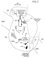
- Figure 2 is a map showing a portion 130 of the geographic region 100 shown in Figure 1.
- the portion 130 of the geographic region 100 shown in Figure 2 includes the wireless coverage area 110(1) that corresponds to the Chicago and Milwaukee metropolitan areas.
- the portion 130 of the geographic region 100 shown in Figure 2 also includes some areas 140 that are located outside the wireless coverage areas 110.
- the wireless coverage area 110(1) is served by a navigation services provider 200(1).
- the navigation services provider 200(1) is part of a navigation services system 210.
- the navigation services system 210 serves end users (e.g., vehicle drivers and passengers, as well as other persons) in the wireless coverage area 110(1).
- the navigation services system 210 is used by the end users to obtain navigation-related services (including map-related services) and/or data wirelessly from the navigation services provider 200(1) while the end users are located in the wireless coverage area 110(1).
- the navigation-related services or data that the end users obtain from the navigation services provider 200 relate to the wireless coverage area 110(1) as well as areas outside the wireless coverage area 110(1).
- the navigation-related services include information about travel along roads 224 located in the wireless coverage area 110(1) as well as roads located in areas outside the wireless coverage area 110(1).
- the navigation-related services include route calculation and guidance, people and business finding services (e.g., electronic yellow and white pages), maps, point of interest searching, destination selection, and so on.
- End users located in the coverage area 110(1) use various different computer platforms 230 to access the navigation services provider 200 to request and obtain navigation-related and map-related features and geographic data.
- These various computer platforms 230 may include navigation system units 232 located in vehicles 234, personal computers 236, personal organizers (e.g., PDAs, PalmPilot®-type devices) 238, portable phones 240, or any other types of computing device.
- the various end user computing platforms 230 access the navigation services provider 200 over a data communications network 250.
- the data communications network 250 may be part of, or connected to, the Internet.
- the data network 250 may use any suitable technology and/or protocols that are currently available, as well as technology and/or protocols that become available in the future.
- the data network may use WAP, TCP/IP, etc. More than one protocol may be used in the data network 250 with appropriate conversions.
- the wireless portion 254 of the data communications network 250 enables two-way communication between the end user computing platforms 230 and the navigation services provider 200(1).
- the wireless portion 254 may be implemented by any suitable form of wireless communication, including cellular, PCS, satellite, FM, radio, or technologies that may be developed in the future.
- the wireless portion 254 may include one or more transmitters, such as a transponder tower, an antenna tower, an FM tower, satellites, or other suitable means.
- the transmitters include an appropriate communication link to the navigation services provider 200(1). This link may be landbased or may be wireless.
- At least some of the end user computing devices 230 are mobile devices. These mobile end user computing devices 230 use the wireless portion 254 of the data communications network 250 to access the navigation services provider 200(1). These mobile end user computing devices 230 includes the appropriate hardware and software to access the navigation services provider 200 over the wireless communications network 254 of the data network 250. Some end user computing devices may not be mobile devices. For example, these non-mobile end user computing devices may include desktop personal computers 236. These non-mobile end user computing devices 230 may access the navigation services provider 200(1) over the data communications network 250 without using the wireless portion 254.
- the end users obtain navigation-related services or data wirelessly from the navigation services provider 200(1) while the end users are located in the wireless coverage area 110(1). So long as the end users remain in the coverage area 110(1), they are within the range of service coverage of the wireless communications system 254 and can obtain navigation-related services or data from the navigation services provider 200(1). However, if an end user travels outside the wireless coverage area 110(1), he/she becomes out of range of the service coverage of the wireless communications system 254 and as a result, is unable to obtain navigation-related services or data wirelessly from the navigation services provider 200(1).
- a present embodiment includes a feature whereby end users are provided with information about the geographic range of availability of wireless navigation-related or data services.
- end users are provided with wireless coverage data that indicate the geographic range of availability of wireless navigation-related or data.
- These wireless coverage data can be used by an application in the end user's computing device 230 to indicate to the end user where (geographically), navigation-related or data are available wirelessly.
- these wireless coverage data can also be used to indicate to the end user where (geographically), navigation-related or data are not available wirelessly. (This information about wireless coverage availability can be used on the end user's computing device in several different ways, as explained in more detail below.)
- the wireless coverage data are associated with (or included in) a geographic database 300.
- the geographic database 300 is used by the navigation services system 210.
- the geographic database 300 includes data representing the roads and intersections in the wireless coverage area 110(1).
- the data contained in the geographic database 300 includes information relating to the represented roads and intersections, such as turn restrictions at intersections, speed limits along the roads, street names of the various roads, address ranges along the roads, and so on.
- the geographic database 300 also contains information about points of interest and businesses located in the wireless coverage area 110(1).
- the geographic database 300 also contains other information about the wireless coverage area 110(1), such as information about government divisions (e.g., cities, states), government services (e.g., police stations, post offices, community centers), postal zones, area codes, etc.
- the geographic database 300 also includes data about areas outside the wireless coverage area 110(1).
- the geographic database 300 does not necessarily include data about areas outside the wireless coverage area 110(1).
- the wireless coverage data are included as data attributes of other geographic features that are represented by the geographic database 300.
- wireless coverage data are included as attributes of road segment data.
- the geographic database 300 in Figure 2 includes data that represents roads.
- there is at least one database entry also referred to as "entity” or "record" for each road segment represented in a geographic region.
- a road segment refers to a portion of a road between two immediately adjacent intersections or between a dead end and the intersection immediately adjacent to the dead end.
- a road segment can also refer to a portion of a road along which all the attributes of the road are the same.
- Figure 3 shows some of the components of a data record 310 that represents a road segment.
- the road segment data record 310 is included in the geographic database 300.
- Each road segment data record 310 may have associated with it information (such as "attributes", "fields”, etc.) that describe features of the represented road segment.
- the road segment record 310 includes a segment ID 310(1) by which the data record can be identified in the geographic database 300.
- the road segment data record 310 may also include data 310(2) that indicates the restrictions, if any, on the direction of vehicular travel permitted on the represented road segment.
- the road segment data record 310 includes data 310(3) that indicates a speed limit or speed category (i.e., the maximum permitted vehicular speed of travel on the represented road segment).
- the road segment data record 310 may also include data 310(4) indicating whether the represented road segment is part of a controlled access road (such as an expressway), a ramp to a controlled access road, a bridge, a tunnel, a toll road, a ferry, and so on.
- a controlled access road such as an expressway
- the road segment data record 310 also includes data 310(5) providing the geographic coordinates (e.g., the latitude and longitude) of the endpoints of the represented road segment.
- this data 310(5) are references to the node data records 312(1) and 312(2) that represent the endpoints of the represented road segment.
- the road segment data record 310 also includes data 310(6) indicating the postal zone in which the road segment is located, data 310(7) indicating the state in which the road segment is located, and data 310(8) indicating the city in which the road segment is located.
- the road segment record 310 may also include or be associated with other data 310(9) that refer to various other attributes of the represented road segment.
- the road segment data record may include data identifying what turn restrictions exist at each of the nodes which correspond to intersections at the ends of the represented road segment, the name or names by which the represented road segment is known, the street address ranges along the represented road segment, and so on.
- the various attributes associated with a road segment may be included in a single road segment record, or preferably are included in more than one type of road segment record which are cross-referenced to each other.
- the road segment record 310 includes a data attribute 310(10) relating to wireless coverage.
- the wireless coverage data attribute 310(10) indicates whether navigation-related services or data are available wirelessly from a remotely located navigation services provider when an end user is located on the road segment represented by the road segment record.
- the wireless coverage data attribute 310(10) may also identify the navigation services provider and the levels of service that are available (if different levels exist), as well as other data.
- data that indicate the range of wireless coverage can be associated with data that represent types of geographic features other than road segments.
- data that indicate the range of wireless coverage can be associated with data records that represent nodes. Nodes refer to the points at each end of a road segment.
- the geographic database 300 includes data records that represent nodes, i.e., node data records. Some of the components of a node data record 312 are shown in Figure 4. Each node data record 312 may have associated information (such as "attributes", "fields”, etc.) that describe features of the represented node.
- the node record 312 includes a node ID 312(1) by which the data record can be identified in the geographic database 300.
- the node record 312 also include data 312(2) that indicate the geographic position (e.g., its latitude and longitude coordinates) of the represented node.
- the node record 312 may also include data 312(3) that indicate the road segment(s) that connect to it.
- the node record 312 may also include or be associated with other data 312(4) that refer to various other attributes of the represented node.
- the node record 312 includes a data attribute 312(5) relating to wireless coverage.
- the wireless coverage data attribute 312(5) indicates whether navigation-related services or data are available wirelessly from a remotely located navigation services provider when an end user is located at the node represented by the node record.
- the wireless coverage data attribute 312(5) may also identify the navigation services provider and the levels of service that are available, as well as other data.
- data that indicate the range of wireless coverage can be associated with data that represent postal zones.
- the geographic database 300 includes postal zone records. Some of the components of a postal zone record 316 are shown in Figure 5.
- the postal zone record 316 includes an ID 316(1) by which the postal zone record can be identified in the geographic database 300.
- the postal zone record 316 may also include data 316(2) that indicate the communities located within the represented postal zone.
- the postal zone record 316 may also include data 316(3) that indicate the locations(s) of post offices within the represented postal zone.
- the postal zone record 316 may also include or be associated with other data 316(4) that refer to various other attributes of the represented postal zone.
- the postal zone record 316 includes a data attribute 316(5) relating to wireless coverage.
- the wireless coverage data attribute 316(5) indicates whether navigation-related services or data are available wirelessly from a remotely located navigation services provider when an end user is located in the postal zone represented by the postal zone record.
- the wireless coverage data attribute 316(5) may also include other types of information, as explained above.
- data that indicate the range of wireless coverage are associated with data records that represent administrative zones.
- Administrative zones include countries, states, cities (towns, villages, etc.), counties, townships, provinces, etc.
- the geographic database 300 includes administrative zone records. Some of the components of an administrative zone record 320 are shown in Figure 6.
- the administrative zone record 320 includes an ID 320(1) by which the administrative zone record can be identified in the geographic database 300.
- the administrative zone record 320 also includes data 320(2) that indicate related administrative zones.
- the administrative zone record 320 may also include data 320(3) that indicate the locations(s) of administrative buildings (e.g., city halls, state capitols, court houses) within the represented administrative zone.
- the administrative zone data record 320 also includes data 320(4) that indicate the boundaries of the administrative zone.
- the administrative zone record 320 may also include or be associated with other data 320(5) that refer to various other attributes of the represented administrative zone.
- the administrative zone data record 320 also includes a data attribute 320(6) relating to wireless coverage.
- the wireless coverage data attribute 320(6) indicates whether navigation-related services or data are available wirelessly from a remotely located navigation services provider when an end user is located in the administrative zone represented by the administrative zone record.
- the wireless coverage data attribute 320(6) may also include other types of information, as explained above.
- the geographic database 300 includes wireless coverage area records. Some of the components of a wireless coverage area record 322 are shown in Figure 7.
- the wireless coverage area record 322 includes an ID 322(1) by which the wireless coverage area record can be identified in the geographic database 300.
- the wireless coverage area record 322 also includes data 322(2) that indicate the boundaries of the represented wireless coverage area. The boundaries of the wireless coverage area can be defined in any way.
- the wireless coverage data attribute 322(3) may also identify the navigation services provider and the levels of service that are available, as well as other data, as explained above.
- the wireless coverage area record 322 may also include or be associated with other data 322(4) that refer to various other attributes of the wireless coverage area.
- the wireless coverage data that indicate the geographic range of availability of wireless navigation-related services or data are provided to end users.
- the wireless coverage data is used by end users to indicate where (geographically) navigation-related services or data are available wirelessly.
- each end user uses a computing platform (230 in Figure 2) to obtain data or navigation-related or map-related services from the navigation services provider 200(1).
- Figure 8 is a block diagram that shows components included in one of the end user's computing platforms 230.
- end users may use different kinds of computing platforms to access the navigation services provider 220(1).
- Different end user computing platforms may have different hardware and software and the navigation-related functions that are performed on the end users' computing platforms may vary from one end user platform to another. Accordingly, Figure 8 shows an example of one configuration of an end user computing platform. It is understood that not all end user computing platforms may necessarily provide all the functions described in connection with the embodiment in Figure 8 and that some end user computing platforms may provide additional or other functions.
- the end user's computing platform 230 includes a communications system 400.
- the communications system 400 in the end user's computing platform 230 includes the hardware and software components needed to receive messages from and send messages to the navigation services provider (200(1) in Figure 2) over the data network 250.
- the communications system 400 interfaces with other components in the end user's computing platform 230.
- the end user's computing platform 230 also includes a user interface 410.
- the user interface 410 allows the end user to provide input to and receive information from the end user's computing platform 230.
- the user interface 410 includes hardware and software components.
- the user interface 410 may include a display, a microphone, speakers, a keypad, or other kinds of means for inputting information into the computing platform and outputting information therefrom.
- the user interface 410 includes supporting software that may provide menus, prompts, audio, etc.
- the user interface 410 interfaces with other components in the end user's computing platform 230.
- the navigation-related applications 420 use the data obtained from the navigation services provider 200(1).
- One of the navigation-related applications 420 is a positioning application 420(1).
- the positioning application 420(1) uses geographic data obtained from the navigation services provider 200(1) to determine the position of the end user's computing platform 230 relative to data representing the road network.
- the positioning application 420(1) may also obtain data from a positioning system 430 which is part of the end user's computing platform 230.
- the positioning system 430 may use GPS, dead-reckoning, or a combination of these or other technologies to determine the location of the end user's computing platform 230. Methods for performing positioning are disclosed in U.S. Pat. No.
- the positioning system 430 may also use technologies that determine cell phone positions (or other wireless phone positions) in a geographic area. These technologies may employ triangulation, time-of-arrival, or other techniques implemented with equipment located away from a cell phone to determine the location of the cell phone in a geographic area.
- the positioning application 420(1) and the positioning system 430 are optional, i.e., not all end users' computing platforms may provide for or support positioning.
- route guidance 420(2) Another of the navigation applications 420 on the end user's computing platform is route guidance 420(2).
- the route guidance application 420(2) uses data from the navigation services provider 200(1) to provide instructions for the end user to travel to a desired destination. Methods for performing route guidance using geographic data are disclosed in U.S. Pat. No. 6,199,013, the entire disclosure of which is incorporated herein by reference.
- map display 420(3) Another of the navigation applications 420 on the end user's computing platform is map display 420(3).
- the map display 420(3) uses data from the navigation services provider 200(1) to provide maps graphically on the display screen of the user interface 410 of the end user's computing platform.
- the maps may show the area around the location of the end user's computing platform, the area along a route that the end user is following, the area around a location specified by the end user, or any other specified area.
- Methods for performing map display using geographic data are disclosed in U.S. Pat. Nos. 6,092,076 and 6,163,749, the entire disclosures of which are incorporated herein by reference.
- the wireless coverage data can be used to indicate to end users where (geographically), navigation-related services or data are available wirelessly (and likewise where navigation-related services or data are not available wirelessly).
- end users' computing platforms 230 request wireless coverage data from the navigation services provider 200(1). An end user's computing platform 230 makes this request while it is located within one of the areas in which navigation-related or map-related data are available wirelessly.
- the end user's computing platform uses the wireless coverage data to show a coverage map on the display screen of the end user's computing.
- the coverage map may be generated by a coverage map generation application 420(6)(1).
- the coverage map generation application 420(6)(1) may be included on the end user's computing platform.
- the coverage map generation application 420(6)(1) may be part of the map display program installed on the end user's computing platform.
- the coverage map generation application 420(6)(1) may be a separate program.
- the coverage map generation application 420(6)(1) may be downloaded as an applet or a plug-in from the navigation services provider 200(1) along with the wireless coverage data.
- the coverage map rendered on the display screen of the end user's computing platform indicates the areas in which navigation-related or map-related data are available wirelessly and also indicates areas in which navigation-related or map-related data are not available wirelessly.
- the coverage map also shows the current position of the end user's computing platform.
- Figure 9 shows an example of this feature.
- Figure 9 shows the display screen of the user interface 410 of the end user's computing platform 230.
- On the display screen is a map showing areas in which navigation-related services or data are available wirelessly and areas in which navigation-related services or data are not available wirelessly.
- the areas in which navigation-related services or data are not available wirelessly are shown as hatched.
- the current location of the end user is indicated on the coverage map.
- the current location of the end user can be determined using the positioning application (420(1) in Figure 8) or by any other means.
- a message is overlaid on the display screen.
- the message indicates to the end user the areas in which navigation-related services or data are available wirelessly.
- a message may be shown in the display screen that indicates to the end user the areas in which navigation-related services or data are not available wirelessly.
- the wireless coverage data can be used on the end user's computing platform to provide the end user with a warning that the end user is about to leave an area in which navigation-related services or data are available wirelessly.
- This warning can be generated by a wireless coverage warning application 420(6)(2) in the end user's computing platform.
- the warning may be provided visually on the display screen of the user interface of the end user's computing platform.
- the warning can be provided audibly using a speaker of the user interface of the end user's computing platform. Both visual and audio warnings may be provided.
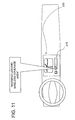
- the warning may be provided in combination with the display of a coverage map, as explained above. Figures 10 and 11 show examples of these warning features.
- a message can be provided when the end user enters a wireless coverage area.
- the message may be similar to the warnings provided when leaving a wireless coverage area.
- An advantage of this embodiment is that the end user can make additional requests for data about areas outside a wireless coverage area while still within the wireless coverage area. For example, the user may request navigation-related services or data for areas outside the wireless coverage area. These data for areas outside the wireless coverage area are then saved on the end user's computing platform so that they can be used when the end user travels outside the wireless coverage area. These data can be used to generate map displays, provide routing guidance, and so on. The end user can also request data for a route that extends through an uncovered area.
- a wireless data downloading application (420(6)(3) in Figure 8) on the end user's computing platform automatically requests and obtains data for uncovered areas whenever the end user approaches an uncovered area.
- the wireless data downloading application 420(6)(3) on the end user's computing platform may download all the data for an uncovered area being approached.
- the wireless data downloading application 420(6)(3) on the end user's computing platform automatically downloads sufficient data for the uncovered areas through which the end user is expected to travel.
- the end user's computing platform obtained the wireless coverage data from the navigation services provider.
- the wireless coverage data may be stored on media located with the end user.
- the wireless coverage data may be stored on a CD-ROM or DVD installed with the end user's computing platform.
- an end user's computing platform may provide navigation-related services using a geographic database installed locally with the end user's computing platform.
- a geographic database installed locally with the end user's computing platform is used for certain types of navigation-related functions, such as route guidance, map display, or route guidance.
- the end user's computing platform communicates with the navigation services provider for certain functions, such as real-time traffic, updates, and weather.
- the end user can be provided with warnings about leaving or entering wireless coverage areas. When the end user leaves a wireless coverage area, the features provided by the navigation services provider, such as real-time traffic and updates, are not available. However, the features that can be provided using only the locally installed geographic database are still available.
- the end user leaves a wireless coverage area
- features that rely on the availability of data wirelessly such as real-time traffic and updates, are still provided using data that have been downloaded prior to leaving the wireless coverage area.
- the data that have been downloaded while in a wireless coverage area can be used for a period of time until they become obsolete.
- traffic data an end user who has left a wireless coverage area may be able to use traffic data that have been downloaded from a navigation services provider prior to leaving the wireless coverage area until the traffic data becomes obsolete, e.g., an hour.
- traffic related data and updates for the roads in and along the route are downloaded to the end user's computing platform prior to leaving the wireless coverage area.
- wireless coverage data are associated with a geographic database to indicate areas in which navigation-related services or data are available wirelessly.
- the wireless coverage data can indicate areas in which navigation-related services or data are not available wirelessly.
- end user computing platforms were described as having certain navigation applications, such as positioning, route guidance, and map display.
- some or all of these navigation applications may reside on the navigation services server.
- end users may be able to operate these server-based navigation applications using their local computing platforms, or may be able to obtain the results from these server-based applications using their local computing platforms.
- the wireless coverage data can be used to restrict selection of destinations.
- a destination of a given type e.g., points of interest, such as hotels, restaurants, etc.
- the list of available destinations may be restricted to only those that are located within wireless coverage areas.
- destinations of a given type that are located outside wireless coverage areas are not shown to end users as being available.
- destinations that are located outside wireless coverage areas may be made available to some users (such as those having systems capable of downloading sufficient data for travel in the uncovered areas), but not to other users.
- destinations that are located outside wireless coverage areas may be made available to users, but with a warning that the destinations are located outside wireless coverage areas.
- an end user may be able to choose whether destinations that are located outside wireless coverage areas are returned when searching.
- an end user may be able to select a preference for destinations that are located in wireless coverage areas when searching.
- the wireless coverage data can be used to restrict calculation of routes.
- a route calculation application located on either the navigation services server or on the end user's computing platform
- an end user may be able to choose whether any portion of a route crosses outside wireless coverage areas.
- an end user may be able to select a preference for routes that are located in wireless coverage areas so that routes remain inside wireless coverage areas whenever possible.
Abstract
Description
- The present invention relates to geographic data and systems that use geographic data, and more particularly, the present invention relates to a feature provided by a system, such as a navigation system, whereby a user of the system is provided with information that indicates areas in which navigation-related data are available wirelessly.
- There are various computer architectures for navigation systems that provide navigation-related features (including map-related features). In one type of architecture for a navigation system, end users (such as vehicle drivers, passengers, and others) use a wireless communications system to obtain navigation-related services or data from a remotely located navigation services provider. The end users use various computer platforms (e.g., different kinds of electronic devices and/or systems) to connect to the wireless communications system to access the remotely located navigation service provider. Associated with the remotely located navigation services provider is a geographic database. When an end user uses his/her computer platform to request a navigation-related service or data, the remotely located navigation service provider accesses the geographic database associated therewith and then provides the requested service or data to the requesting end user's computer platform via the wireless communications system.
- This type of navigation system architecture provides several advantages. One advantage relates to providing updated data. There is a continuing need to update the data used by a navigation system. For example, new streets are built, road construction closes roads, detours are established, new businesses open, posted speed limits change, new turn restrictions are established at intersections, streets are renamed, and so on. These kinds of changes can affect travel through a geographic region. Accordingly, the data used by a navigation system should be updated on a regular basis to accurately reflect changes in the represented geographic features. A computer architecture in which end user computing platforms obtain data from a single central geographic database associated with a navigation services provider affords an advantage with respect to the updating of the geographic data. With a computer architecture in which end user computing platforms obtain data wirelessly from a single central geographic database associated with a navigation services provider, updates need to be applied only to the central database.
- Although there are advantages associated with a navigation system architecture in which individual end user computer platforms request and obtain navigation-related services and data wirelessly from a single central geographic database associated with a navigation services provider, there are considerations that need to be addressed. One consideration relates to the coverage area(s) in which end users can obtain navigation-related services and data wirelessly. According to one type of navigation system architecture, a navigation services provider provides navigation-related services and data with respect to a coverage area. A wireless communications system, associated with the navigation services provider, is available throughout the coverage area. End users located throughout the coverage area use the wireless communications system to access the navigation services provider to obtain navigation-related services and data. The coverage area served by the wireless communications system and navigation services provider may correspond to a metropolitan region. Alternatively, the coverage area associated with a navigation services provider may correspond to a state or region of the country. Thus, within an entire country, such as the United States, there may be a number of different coverage areas that are served by one or more navigation services providers. According to this type of navigation system architecture, navigation-related services and data are not available wirelessly outside the coverage areas. The unavailability of navigation-related services or data outside of coverage areas may be inconvenient to some end users. Accordingly, it would be preferable to reduce or minimize any inconvenience to end users of this navigation system architecture occasioned by the lack of navigation-related services or data outside the coverage areas served by wireless communications systems associated with navigation services providers.
- To address these and other objectives, the present invention comprises wireless coverage data associated with a geographic database that contains data that represent a road network in a geographic region. The wireless coverage data indicate one or more areas within the geographic region in which navigation-related services or data from a navigation services provider are available wirelessly, or conversely, areas within the geographic region in which navigation-related services or data from a navigation services provider are not available wirelessly. An end user obtains the wireless coverage data. The wireless coverage data are used to indicate to the end user areas in which navigation-related services or data from a navigation services provider are available wirelessly or areas in which navigation-related services or data from a navigation services provider are not available wirelessly. The wireless coverage data may also be used to warn the end user when he/she is leaving an area in which navigation-related services or data from a navigation services provider are available wirelessly. Data for uncovered areas can be downloaded to an end user's computing platform while the end user is still within an area in which navigation-related data and services from a navigation services provider are available wirelessly.
-
- Figure 1 is a map showing a geographic region.
- Figure 2 a map showing a portion of the geographic region shown in Figure 1.
- Figure 3 is a block diagram that shows some of the components of a road segment data record contained in the geographic database of Figure 2.
- Figure 4 is a block diagram that shows some of the components of a node data record contained in the geographic database of Figure 2 according to an alternative embodiment.
- Figure 5 is a block diagram that shows some of the components of a postal zone data record contained in the geographic database of Figure 2 according to an alternative embodiment.
- Figure 6 is a block diagram that shows some of the components of an administrative area data record contained in the geographic database of Figure 2 according to an alternative embodiment.
- Figure 7 is a block diagram that shows some of the components of a wireless coverage area data record contained in the geographic database of Figure 2 according to an alternative embodiment.
- Figure 8 is a block diagram showing components of one of the end user's computing platforms shown in Figure 2.
- Figure 9 is an illustration of the end user's computing platform of Figure 8 showing a map image on the display screen relating to a wireless coverage.
- Figure 10 is an illustration of the end user's computing platform of Figure 8 including a visual warning message about the availability of wireless coverage.
- Figure 11 is an illustration of the end user's computing platform of Figure 8 including an audible warning message about the availability of wireless coverage.
-
- Figure 1 is a map showing a
geographic region 100. In Figure 1, thegeographic region 100 includes a portion of the Midwest United States. The portion shown in Figure 1 is exemplary and the present embodiment can be applied in any geographic region in the United States or in any other country. - In the map of the
geographic region 100 in Figure 1, severalwireless coverage areas 110 are shown. Thesewireless coverage areas 110 are labeled, 110(1), 110(2), 110(3)... etc. In thegeographic region 100 shown in Figure 1, some of thesecoverage areas 110 correspond to metropolitan areas, or combinations of metropolitan areas. For example, the wireless coverage area 110(1) corresponds to the Chicago and Milwaukee metropolitan areas and the wireless coverage area 110(2) corresponds to the Indianapolis metropolitan area. In addition, some of thecoverage areas 110 in Figure 1 correspond to connecting travel corridors. For example, the wireless coverage area 110(3) corresponds to a connecting travel corridor located between Chicago and Indianapolis. (The wireless coverage area 110(3) is located along I-65.) Thecoverage areas 110 indicated in Figure 1 indicate areas in which navigation data area available wirelessly from a navigation services provider. - Figure 2 is a map showing a
portion 130 of thegeographic region 100 shown in Figure 1. Theportion 130 of thegeographic region 100 shown in Figure 2 includes the wireless coverage area 110(1) that corresponds to the Chicago and Milwaukee metropolitan areas. Theportion 130 of thegeographic region 100 shown in Figure 2 also includes someareas 140 that are located outside thewireless coverage areas 110. - The wireless coverage area 110(1) is served by a navigation services provider 200(1). The navigation services provider 200(1) is part of a
navigation services system 210. Thenavigation services system 210 serves end users (e.g., vehicle drivers and passengers, as well as other persons) in the wireless coverage area 110(1). Thenavigation services system 210 is used by the end users to obtain navigation-related services (including map-related services) and/or data wirelessly from the navigation services provider 200(1) while the end users are located in the wireless coverage area 110(1). The navigation-related services or data that the end users obtain from thenavigation services provider 200 relate to the wireless coverage area 110(1) as well as areas outside the wireless coverage area 110(1). The navigation-related services include information about travel alongroads 224 located in the wireless coverage area 110(1) as well as roads located in areas outside the wireless coverage area 110(1). The navigation-related services include route calculation and guidance, people and business finding services (e.g., electronic yellow and white pages), maps, point of interest searching, destination selection, and so on. - End users located in the coverage area 110(1) use various
different computer platforms 230 to access thenavigation services provider 200 to request and obtain navigation-related and map-related features and geographic data. These various computer platforms 230 (also referred to as "end user computing devices" or "client computing platforms") may includenavigation system units 232 located invehicles 234,personal computers 236, personal organizers (e.g., PDAs, PalmPilot®-type devices) 238,portable phones 240, or any other types of computing device. - The various end
user computing platforms 230 access thenavigation services provider 200 over adata communications network 250. Thedata communications network 250 may be part of, or connected to, the Internet. Thedata network 250 may use any suitable technology and/or protocols that are currently available, as well as technology and/or protocols that become available in the future. For example, the data network may use WAP, TCP/IP, etc. More than one protocol may be used in thedata network 250 with appropriate conversions. - At least a portion of the
data communications network 250 includes awireless portion 254. Thewireless portion 254 of thedata communications network 250 enables two-way communication between the enduser computing platforms 230 and the navigation services provider 200(1). Thewireless portion 254 may be implemented by any suitable form of wireless communication, including cellular, PCS, satellite, FM, radio, or technologies that may be developed in the future. Thewireless portion 254 may include one or more transmitters, such as a transponder tower, an antenna tower, an FM tower, satellites, or other suitable means. The transmitters include an appropriate communication link to the navigation services provider 200(1). This link may be landbased or may be wireless. - At least some of the end
user computing devices 230 are mobile devices. These mobile enduser computing devices 230 use thewireless portion 254 of thedata communications network 250 to access the navigation services provider 200(1). These mobile enduser computing devices 230 includes the appropriate hardware and software to access thenavigation services provider 200 over thewireless communications network 254 of thedata network 250. Some end user computing devices may not be mobile devices. For example, these non-mobile end user computing devices may include desktoppersonal computers 236. These non-mobile enduser computing devices 230 may access the navigation services provider 200(1) over thedata communications network 250 without using thewireless portion 254. - As mentioned above, the end users obtain navigation-related services or data wirelessly from the navigation services provider 200(1) while the end users are located in the wireless coverage area 110(1). So long as the end users remain in the coverage area 110(1), they are within the range of service coverage of the
wireless communications system 254 and can obtain navigation-related services or data from the navigation services provider 200(1). However, if an end user travels outside the wireless coverage area 110(1), he/she becomes out of range of the service coverage of thewireless communications system 254 and as a result, is unable to obtain navigation-related services or data wirelessly from the navigation services provider 200(1). - In order to assist end users, a present embodiment includes a feature whereby end users are provided with information about the geographic range of availability of wireless navigation-related or data services. In one embodiment, end users are provided with wireless coverage data that indicate the geographic range of availability of wireless navigation-related or data. These wireless coverage data can be used by an application in the end user's
computing device 230 to indicate to the end user where (geographically), navigation-related or data are available wirelessly. In addition, these wireless coverage data can also be used to indicate to the end user where (geographically), navigation-related or data are not available wirelessly. (This information about wireless coverage availability can be used on the end user's computing device in several different ways, as explained in more detail below.) - According to one embodiment, the wireless coverage data are associated with (or included in) a
geographic database 300. Thegeographic database 300 is used by thenavigation services system 210. Thegeographic database 300 includes data representing the roads and intersections in the wireless coverage area 110(1). The data contained in thegeographic database 300 includes information relating to the represented roads and intersections, such as turn restrictions at intersections, speed limits along the roads, street names of the various roads, address ranges along the roads, and so on. Thegeographic database 300 also contains information about points of interest and businesses located in the wireless coverage area 110(1). Thegeographic database 300 also contains other information about the wireless coverage area 110(1), such as information about government divisions (e.g., cities, states), government services (e.g., police stations, post offices, community centers), postal zones, area codes, etc. In this embodiment, thegeographic database 300 also includes data about areas outside the wireless coverage area 110(1). However, in an alternative embodiment, thegeographic database 300 does not necessarily include data about areas outside the wireless coverage area 110(1). - According to some embodiments, the wireless coverage data are included as data attributes of other geographic features that are represented by the
geographic database 300. - In one embodiment, wireless coverage data are included as attributes of road segment data. The
geographic database 300 in Figure 2 includes data that represents roads. In the embodiment of thegeographic database 300, there is at least one database entry (also referred to as "entity" or "record") for each road segment represented in a geographic region. A road segment refers to a portion of a road between two immediately adjacent intersections or between a dead end and the intersection immediately adjacent to the dead end. A road segment can also refer to a portion of a road along which all the attributes of the road are the same. - Figure 3 shows some of the components of a
data record 310 that represents a road segment. The roadsegment data record 310 is included in thegeographic database 300. Each roadsegment data record 310 may have associated with it information (such as "attributes", "fields", etc.) that describe features of the represented road segment. Theroad segment record 310 includes a segment ID 310(1) by which the data record can be identified in thegeographic database 300. The roadsegment data record 310 may also include data 310(2) that indicates the restrictions, if any, on the direction of vehicular travel permitted on the represented road segment. The roadsegment data record 310 includes data 310(3) that indicates a speed limit or speed category (i.e., the maximum permitted vehicular speed of travel on the represented road segment). The roadsegment data record 310 may also include data 310(4) indicating whether the represented road segment is part of a controlled access road (such as an expressway), a ramp to a controlled access road, a bridge, a tunnel, a toll road, a ferry, and so on. - The road
segment data record 310 also includes data 310(5) providing the geographic coordinates (e.g., the latitude and longitude) of the endpoints of the represented road segment. In one embodiment, this data 310(5) are references to the node data records 312(1) and 312(2) that represent the endpoints of the represented road segment. - The road
segment data record 310 also includes data 310(6) indicating the postal zone in which the road segment is located, data 310(7) indicating the state in which the road segment is located, and data 310(8) indicating the city in which the road segment is located. - The
road segment record 310 may also include or be associated with other data 310(9) that refer to various other attributes of the represented road segment. For example, the road segment data record may include data identifying what turn restrictions exist at each of the nodes which correspond to intersections at the ends of the represented road segment, the name or names by which the represented road segment is known, the street address ranges along the represented road segment, and so on. The various attributes associated with a road segment may be included in a single road segment record, or preferably are included in more than one type of road segment record which are cross-referenced to each other. - In the embodiment shown in Figure 3, the
road segment record 310 includes a data attribute 310(10) relating to wireless coverage. The wireless coverage data attribute 310(10) indicates whether navigation-related services or data are available wirelessly from a remotely located navigation services provider when an end user is located on the road segment represented by the road segment record. The wireless coverage data attribute 310(10) may also identify the navigation services provider and the levels of service that are available (if different levels exist), as well as other data. - In alternative embodiments, data that indicate the range of wireless coverage can be associated with data that represent types of geographic features other than road segments. As an example, according to a second embodiment, data that indicate the range of wireless coverage can be associated with data records that represent nodes. Nodes refer to the points at each end of a road segment. According to this embodiment, the
geographic database 300 includes data records that represent nodes, i.e., node data records. Some of the components of anode data record 312 are shown in Figure 4. Eachnode data record 312 may have associated information (such as "attributes", "fields", etc.) that describe features of the represented node. Thenode record 312 includes a node ID 312(1) by which the data record can be identified in thegeographic database 300. Thenode record 312 also include data 312(2) that indicate the geographic position (e.g., its latitude and longitude coordinates) of the represented node. Thenode record 312 may also include data 312(3) that indicate the road segment(s) that connect to it. Thenode record 312 may also include or be associated with other data 312(4) that refer to various other attributes of the represented node. - In this embodiment, the
node record 312 includes a data attribute 312(5) relating to wireless coverage. The wireless coverage data attribute 312(5) indicates whether navigation-related services or data are available wirelessly from a remotely located navigation services provider when an end user is located at the node represented by the node record. The wireless coverage data attribute 312(5) may also identify the navigation services provider and the levels of service that are available, as well as other data. - In another alternative embodiment, data that indicate the range of wireless coverage can be associated with data that represent postal zones. According to this embodiment, the
geographic database 300 includes postal zone records. Some of the components of apostal zone record 316 are shown in Figure 5. Thepostal zone record 316 includes an ID 316(1) by which the postal zone record can be identified in thegeographic database 300. Thepostal zone record 316 may also include data 316(2) that indicate the communities located within the represented postal zone. Thepostal zone record 316 may also include data 316(3) that indicate the locations(s) of post offices within the represented postal zone. Thepostal zone record 316 may also include or be associated with other data 316(4) that refer to various other attributes of the represented postal zone. - In this embodiment, the
postal zone record 316 includes a data attribute 316(5) relating to wireless coverage. The wireless coverage data attribute 316(5) indicates whether navigation-related services or data are available wirelessly from a remotely located navigation services provider when an end user is located in the postal zone represented by the postal zone record. The wireless coverage data attribute 316(5) may also include other types of information, as explained above. - In a fourth embodiment, data that indicate the range of wireless coverage are associated with data records that represent administrative zones. Administrative zones include countries, states, cities (towns, villages, etc.), counties, townships, provinces, etc. According to this embodiment, the
geographic database 300 includes administrative zone records. Some of the components of anadministrative zone record 320 are shown in Figure 6. Theadministrative zone record 320 includes an ID 320(1) by which the administrative zone record can be identified in thegeographic database 300. Theadministrative zone record 320 also includes data 320(2) that indicate related administrative zones. Theadministrative zone record 320 may also include data 320(3) that indicate the locations(s) of administrative buildings (e.g., city halls, state capitols, court houses) within the represented administrative zone. The administrativezone data record 320 also includes data 320(4) that indicate the boundaries of the administrative zone. Theadministrative zone record 320 may also include or be associated with other data 320(5) that refer to various other attributes of the represented administrative zone. - In this embodiment, the administrative
zone data record 320 also includes a data attribute 320(6) relating to wireless coverage. The wireless coverage data attribute 320(6) indicates whether navigation-related services or data are available wirelessly from a remotely located navigation services provider when an end user is located in the administrative zone represented by the administrative zone record. The wireless coverage data attribute 320(6) may also include other types of information, as explained above. - In another alternative embodiment, data that indicate the range of wireless coverage can be defined with respect to an arbitrary boundary. According to this embodiment, the
geographic database 300 includes wireless coverage area records. Some of the components of a wirelesscoverage area record 322 are shown in Figure 7. The wirelesscoverage area record 322 includes an ID 322(1) by which the wireless coverage area record can be identified in thegeographic database 300. The wirelesscoverage area record 322 also includes data 322(2) that indicate the boundaries of the represented wireless coverage area. The boundaries of the wireless coverage area can be defined in any way. The wireless coverage data attribute 322(3) may also identify the navigation services provider and the levels of service that are available, as well as other data, as explained above. The wirelesscoverage area record 322 may also include or be associated with other data 322(4) that refer to various other attributes of the wireless coverage area. - As mentioned above, the wireless coverage data that indicate the geographic range of availability of wireless navigation-related services or data are provided to end users. The wireless coverage data is used by end users to indicate where (geographically) navigation-related services or data are available wirelessly.
- As mentioned above, each end user uses a computing platform (230 in Figure 2) to obtain data or navigation-related or map-related services from the navigation services provider 200(1). Figure 8 is a block diagram that shows components included in one of the end user's
computing platforms 230. As mentioned above, end users may use different kinds of computing platforms to access the navigation services provider 220(1). Different end user computing platforms may have different hardware and software and the navigation-related functions that are performed on the end users' computing platforms may vary from one end user platform to another. Accordingly, Figure 8 shows an example of one configuration of an end user computing platform. It is understood that not all end user computing platforms may necessarily provide all the functions described in connection with the embodiment in Figure 8 and that some end user computing platforms may provide additional or other functions. - Although the different end user computing platforms may have different hardware and software resources, all the end user computing platforms receive data from the navigation services provider (200(1) in Figure 2). The end user's
computing platform 230 includes acommunications system 400. Thecommunications system 400 in the end user'scomputing platform 230 includes the hardware and software components needed to receive messages from and send messages to the navigation services provider (200(1) in Figure 2) over thedata network 250. Thecommunications system 400 interfaces with other components in the end user'scomputing platform 230. - The end user's
computing platform 230 also includes auser interface 410. Theuser interface 410 allows the end user to provide input to and receive information from the end user'scomputing platform 230. Theuser interface 410 includes hardware and software components. For example, theuser interface 410 may include a display, a microphone, speakers, a keypad, or other kinds of means for inputting information into the computing platform and outputting information therefrom. Theuser interface 410 includes supporting software that may provide menus, prompts, audio, etc. Theuser interface 410 interfaces with other components in the end user'scomputing platform 230. - Included on the end user's
computing platform 230 are navigation-relatedapplications 420. The navigation-relatedapplications 420 use the data obtained from the navigation services provider 200(1). One of the navigation-relatedapplications 420 is a positioning application 420(1). The positioning application 420(1) uses geographic data obtained from the navigation services provider 200(1) to determine the position of the end user'scomputing platform 230 relative to data representing the road network. The positioning application 420(1) may also obtain data from apositioning system 430 which is part of the end user'scomputing platform 230. Thepositioning system 430 may use GPS, dead-reckoning, or a combination of these or other technologies to determine the location of the end user'scomputing platform 230. Methods for performing positioning are disclosed in U.S. Pat. No. 6,192,312, the entire disclosure of which is incorporated herein by reference. Thepositioning system 430 may also use technologies that determine cell phone positions (or other wireless phone positions) in a geographic area. These technologies may employ triangulation, time-of-arrival, or other techniques implemented with equipment located away from a cell phone to determine the location of the cell phone in a geographic area. The positioning application 420(1) and thepositioning system 430 are optional, i.e., not all end users' computing platforms may provide for or support positioning. - Another of the
navigation applications 420 on the end user's computing platform is route guidance 420(2). The route guidance application 420(2) uses data from the navigation services provider 200(1) to provide instructions for the end user to travel to a desired destination. Methods for performing route guidance using geographic data are disclosed in U.S. Pat. No. 6,199,013, the entire disclosure of which is incorporated herein by reference. - Another of the
navigation applications 420 on the end user's computing platform is map display 420(3). The map display 420(3) uses data from the navigation services provider 200(1) to provide maps graphically on the display screen of theuser interface 410 of the end user's computing platform. The maps may show the area around the location of the end user's computing platform, the area along a route that the end user is following, the area around a location specified by the end user, or any other specified area. Methods for performing map display using geographic data are disclosed in U.S. Pat. Nos. 6,092,076 and 6,163,749, the entire disclosures of which are incorporated herein by reference. - As mentioned above, the wireless coverage data can be used to indicate to end users where (geographically), navigation-related services or data are available wirelessly (and likewise where navigation-related services or data are not available wirelessly). In one embodiment, end users'
computing platforms 230 request wireless coverage data from the navigation services provider 200(1). An end user'scomputing platform 230 makes this request while it is located within one of the areas in which navigation-related or map-related data are available wirelessly. - In one embodiment, when the end user's computing platform receives the wireless coverage data, it uses the wireless coverage data to show a coverage map on the display screen of the end user's computing. The coverage map may be generated by a coverage map generation application 420(6)(1). The coverage map generation application 420(6)(1) may be included on the end user's computing platform. The coverage map generation application 420(6)(1) may be part of the map display program installed on the end user's computing platform. Alternatively, the coverage map generation application 420(6)(1) may be a separate program. According to still another alternative, the coverage map generation application 420(6)(1) may be downloaded as an applet or a plug-in from the navigation services provider 200(1) along with the wireless coverage data.
- The coverage map rendered on the display screen of the end user's computing platform indicates the areas in which navigation-related or map-related data are available wirelessly and also indicates areas in which navigation-related or map-related data are not available wirelessly. In a preferred embodiment, the coverage map also shows the current position of the end user's computing platform. Figure 9 shows an example of this feature. Figure 9 shows the display screen of the
user interface 410 of the end user'scomputing platform 230. On the display screen is a map showing areas in which navigation-related services or data are available wirelessly and areas in which navigation-related services or data are not available wirelessly. In the embodiment shown in Figure 9, the areas in which navigation-related services or data are not available wirelessly are shown as hatched. (Instead, of showing these areas as hatched, the areas in which navigation-related services or data are not available wirelessly may be shown in a different color, by shading, by boundaries, etc.) In addition, according to this embodiment, the current location of the end user is indicated on the coverage map. The current location of the end user can be determined using the positioning application (420(1) in Figure 8) or by any other means. - According to one alternative feature, a message is overlaid on the display screen. The message indicates to the end user the areas in which navigation-related services or data are available wirelessly. Alternatively, a message may be shown in the display screen that indicates to the end user the areas in which navigation-related services or data are not available wirelessly. Both these features are shown in Figure 9 by means of the boxes containing the words "DATA" and "NO DATA."
- According to another alternative embodiment, the wireless coverage data can be used on the end user's computing platform to provide the end user with a warning that the end user is about to leave an area in which navigation-related services or data are available wirelessly. This warning can be generated by a wireless coverage warning application 420(6)(2) in the end user's computing platform. The warning may be provided visually on the display screen of the user interface of the end user's computing platform. Alternatively, the warning can be provided audibly using a speaker of the user interface of the end user's computing platform. Both visual and audio warnings may be provided. The warning may be provided in combination with the display of a coverage map, as explained above. Figures 10 and 11 show examples of these warning features.
- According to an another alternative embodiment, a message can be provided when the end user enters a wireless coverage area. The message may be similar to the warnings provided when leaving a wireless coverage area.
- An advantage of this embodiment is that the end user can make additional requests for data about areas outside a wireless coverage area while still within the wireless coverage area. For example, the user may request navigation-related services or data for areas outside the wireless coverage area. These data for areas outside the wireless coverage area are then saved on the end user's computing platform so that they can be used when the end user travels outside the wireless coverage area. These data can be used to generate map displays, provide routing guidance, and so on. The end user can also request data for a route that extends through an uncovered area.
- According to another alternative, a wireless data downloading application (420(6)(3) in Figure 8) on the end user's computing platform automatically requests and obtains data for uncovered areas whenever the end user approaches an uncovered area. The wireless data downloading application 420(6)(3) on the end user's computing platform may download all the data for an uncovered area being approached. Alternatively, if the user is traveling along a route to a destination that is located in, or passes through, an uncovered area, the wireless data downloading application 420(6)(3) on the end user's computing platform automatically downloads sufficient data for the uncovered areas through which the end user is expected to travel.
- In the embodiments described above, it was stated that the end user's computing platform obtained the wireless coverage data from the navigation services provider. In an alternative embodiment, the wireless coverage data may be stored on media located with the end user. For example, in one alternative, the wireless coverage data may be stored on a CD-ROM or DVD installed with the end user's computing platform.
- In the embodiments described above, it was stated that end user's computing platforms communicated with the navigation services provider to obtain navigation-related services or data. According to alternative embodiments, an end user's computing platform may provide navigation-related services using a geographic database installed locally with the end user's computing platform. According to this alternative a geographic database installed locally with the end user's computing platform is used for certain types of navigation-related functions, such as route guidance, map display, or route guidance. The end user's computing platform communicates with the navigation services provider for certain functions, such as real-time traffic, updates, and weather. With this type of system, the end user can be provided with warnings about leaving or entering wireless coverage areas. When the end user leaves a wireless coverage area, the features provided by the navigation services provider, such as real-time traffic and updates, are not available. However, the features that can be provided using only the locally installed geographic database are still available.
- According to another alternative, when the end user leaves a wireless coverage area, features that rely on the availability of data wirelessly, such as real-time traffic and updates, are still provided using data that have been downloaded prior to leaving the wireless coverage area. In this alternative, the data that have been downloaded while in a wireless coverage area can be used for a period of time until they become obsolete. For example, in the case of traffic data, an end user who has left a wireless coverage area may be able to use traffic data that have been downloaded from a navigation services provider prior to leaving the wireless coverage area until the traffic data becomes obsolete, e.g., an hour.
- According to another alternative, when an end user is following a route that leaves a wireless coverage area, traffic related data and updates for the roads in and along the route are downloaded to the end user's computing platform prior to leaving the wireless coverage area.
- In some of the embodiments described above, it was stated that wireless coverage data are associated with a geographic database to indicate areas in which navigation-related services or data are available wirelessly. In an alternative, the wireless coverage data can indicate areas in which navigation-related services or data are not available wirelessly.
- In the embodiments described above, end user computing platforms were described as having certain navigation applications, such as positioning, route guidance, and map display. In alternative embodiments, some or all of these navigation applications may reside on the navigation services server. According to these alternative embodiments, end users may be able to operate these server-based navigation applications using their local computing platforms, or may be able to obtain the results from these server-based applications using their local computing platforms.
- According to a further alternative embodiment, the wireless coverage data can be used to restrict selection of destinations. According to one alternative, when an end user is searching for a destination of a given type (e.g., points of interest, such as hotels, restaurants, etc.), the list of available destinations may be restricted to only those that are located within wireless coverage areas. According to this alternative, destinations of a given type that are located outside wireless coverage areas are not shown to end users as being available. According to an alternative, destinations that are located outside wireless coverage areas may be made available to some users (such as those having systems capable of downloading sufficient data for travel in the uncovered areas), but not to other users. Alternatively, destinations that are located outside wireless coverage areas may be made available to users, but with a warning that the destinations are located outside wireless coverage areas. According to yet another alternative, an end user may be able to choose whether destinations that are located outside wireless coverage areas are returned when searching. According to another alternative, an end user may be able to select a preference for destinations that are located in wireless coverage areas when searching.
- According to another further alternative, the wireless coverage data can be used to restrict calculation of routes. When calculating a route to a destination, a route calculation application (located on either the navigation services server or on the end user's computing platform) may restrict the road segments available for inclusion in the route to those located in wireless coverage areas. According to an alternative, an end user may be able to choose whether any portion of a route crosses outside wireless coverage areas. According to another alternative, an end user may be able to select a preference for routes that are located in wireless coverage areas so that routes remain inside wireless coverage areas whenever possible.
- It is intended that the foregoing detailed description be regarded as illustrative rather than limiting and that it is understood that the following claims including all equivalents are intended to define the scope of the invention.
Claims (23)
- An improved geographic database that contains data that represent a road network in a geographic region, wherein the improvement comprises:wireless coverage data associated with said geographic database, wherein said wireless coverage data indicate areas within the geographic region in which navigation-related data from a service provider are available wirelessly.
- An improved geographic database that contains data that represent a road network in a geographic region, wherein the improvement comprises:wireless coverage data associated with said geographic database, wherein said wireless coverage data indicate areas within the geographic region in which navigation-related data from a service provider are not available wirelessly.
- The invention of Claim 1 or 2 wherein said wireless coverage data comprises attributes associated with data records that represents geographic features located in said geographic region.
- The invention of Claim 3 wherein said geographic features are road segments.
- The invention of Claim 3 wherein said geographic features are postal codes.
- The invention of Claim 3 wherein said geographic features are administrative boundaries.
- The invention of Claim 3 wherein said geographic features are areas defined by a developer of the geographic database.
- A method of operation for an end user's computing device that provides navigation-related services to the end user, the method comprising:with the end user's computing device, establishing a wireless communications link with a remotely located navigation services provider; andobtaining wireless coverage data from said remotely located navigation services provider, wherein said wireless coverage data indicate areas in which navigation-related data from the navigation services provider are unavailable wirelessly.
- A method of operation for an end user's computing device that provides navigation-related services to the end user, the method comprising:with the end user's computing device, establishing a wireless communications link with a remotely located navigation services provider; andobtaining wireless coverage data from said remotely located navigation services provider, wherein said wireless coverage data indicate areas in which navigation-related data from the navigation services provider are available wirelessly.
- The method of Claim 8 or 9 further comprising:using the wireless coverage data to indicate on a display screen of said end user's computing device areas in which navigation-related data from the navigation services provider are available wirelessly.
- The method of Claim 10 wherein said areas in which navigation-related data from the navigation services provider are unavailable wirelessly are indicated by color coding.
- The method of Claim 10 wherein said areas in which navigation-related data from the navigation services provider are unavailable wirelessly are indicated by hatching.
- The method of Claim 10 wherein said areas in which navigation-related data from the navigation services provider are unavailable wirelessly are indicated by boundaries.
- The method of Claim 8 or 9 further comprising:using the wireless coverage data to indicate on a display screen of said end user's computing device areas in which navigation-related data from the navigation services provider are available wirelessly.
- The method of Claim 8 or 9 further comprising:using the wireless coverage data to provide a warning that the end user is leaving an area in which navigation-related services are available wirelessly.
- The method of Claim 15 wherein the warning is provided audibly.
- The method of Claim 15 wherein the warning is provided visually.
- The method of Claim 9 further comprising:restricting selection of destinations to those located in said areas in which navigation-related data from the navigation services provider are available wirelessly.
- The method of Claim 8 or 9 further comprising:restricting calculation of routes to limit crossing into areas in which navigation-related data from the navigation services provider are unavailable wirelessly.
- A method of operation for a computing device that provides navigation-related services to an end user, the method comprising:while the computing device is located in a first area in which navigation-related data are available wirelessly from a remotely located navigation services provider, establishing a wireless communications link with the remotely located navigation services provider; andprior to leaving said first area, downloading data for a second area located outside said first area, wherein navigation-related data are not available wirelessly from the remotely located navigation services provider in said second area.
- The method of Claim 20 further comprising:using said data in said computing device to provide navigation-related services while said computing device is located in said second area.
- The method of Claim 20 wherein the data for the second area correspond to a destination to which the end user is traveling and which is located outside said first area.
- The method of Claim 20 wherein the data for the second area correspond to a portion of a route on which a vehicle in which the end user is located is traveling, wherein the portion of the route is located outside the first area.
Applications Claiming Priority (2)
| Application Number | Priority Date | Filing Date | Title |
|---|---|---|---|
| US836501 | 2001-04-17 | ||
| US09/836,501 US7079945B1 (en) | 2001-04-17 | 2001-04-17 | Geographic database including data indicating wireless coverage and method and system for use thereof |
Publications (3)
| Publication Number | Publication Date |
|---|---|
| EP1251334A2 true EP1251334A2 (en) | 2002-10-23 |
| EP1251334A3 EP1251334A3 (en) | 2011-05-04 |
| EP1251334B1 EP1251334B1 (en) | 2012-08-22 |
Family
ID=25272098
Family Applications (1)
| Application Number | Title | Priority Date | Filing Date |
|---|---|---|---|
| EP02252659A Expired - Lifetime EP1251334B1 (en) | 2001-04-17 | 2002-04-15 | Geographic database including data indicating wireless coverage and method and system for use thereof |
Country Status (3)
| Country | Link |
|---|---|
| US (4) | US7079945B1 (en) |
| EP (1) | EP1251334B1 (en) |
| JP (1) | JP4353677B2 (en) |
Cited By (10)
| Publication number | Priority date | Publication date | Assignee | Title |
|---|---|---|---|---|
| EP1934556A1 (en) * | 2005-10-05 | 2008-06-25 | Motorola, Inc. | Method and system of providing navigation information |
| WO2009017522A2 (en) * | 2007-04-30 | 2009-02-05 | Lucent Technologies Inc. | Proximity detection of coverage area boundary and display of mobile station location relative thereto |
| WO2009077332A1 (en) * | 2007-12-14 | 2009-06-25 | Gemalto Sa | A mobile telecommunication equipment with warning functionality as to uncovered area |
| WO2010042516A2 (en) * | 2008-10-07 | 2010-04-15 | Qualcomm Incorporated | Route mapping system and method |
| DE102010045478A1 (en) * | 2010-09-16 | 2012-03-22 | Deutsche Telekom Ag | Method for computation of route in mobile telecommunications network, involves determining network coverage information with respect to user application, and computing route depending on information with respect to network |
| US20120197875A1 (en) * | 2011-01-31 | 2012-08-02 | GM Global Technology Operations LLC | Efficient Information Exchange Between Encountering Vehicles Using Approximate Knowledge Via Hash Functions |
| WO2017050641A1 (en) * | 2015-09-21 | 2017-03-30 | Nokia Solutions And Networks Oy | Method, apparatus and system for destination recommendation and selection |
| FR3071691A1 (en) * | 2017-09-28 | 2019-03-29 | Orange | ROUTE DETERMINATION METHOD AND DEVICE, NAVIGATION METHOD AND DEVICE, AND TERMINAL USING THE SAME |
| WO2019083679A1 (en) * | 2017-10-25 | 2019-05-02 | Qualcomm Incorporated | Method and apparatus for navigation based on route reuse |
| CN111247392B (en) * | 2017-10-25 | 2024-04-16 | 高通股份有限公司 | Method and apparatus for navigation based on route reuse |
Families Citing this family (48)
| Publication number | Priority date | Publication date | Assignee | Title |
|---|---|---|---|---|
| US7079945B1 (en) * | 2001-04-17 | 2006-07-18 | Navteq North America, Llc | Geographic database including data indicating wireless coverage and method and system for use thereof |
| US7333820B2 (en) | 2001-07-17 | 2008-02-19 | Networks In Motion, Inc. | System and method for providing routing, mapping, and relative position information to users of a communication network |
| US7082365B2 (en) * | 2001-08-16 | 2006-07-25 | Networks In Motion, Inc. | Point of interest spatial rating search method and system |
| US7486958B2 (en) * | 2001-09-05 | 2009-02-03 | Networks In Motion, Inc. | System and method for maintaining an online point-of-interest directory |
| US8977284B2 (en) | 2001-10-04 | 2015-03-10 | Traxcell Technologies, LLC | Machine for providing a dynamic data base of geographic location information for a plurality of wireless devices and process for making same |
| US7271742B2 (en) | 2002-03-01 | 2007-09-18 | Networks In Motion, Inc. | Method and apparatus for sending, retrieving and planning location relevant information |
| US7565155B2 (en) * | 2002-04-10 | 2009-07-21 | Networks In Motion | Method and system for dynamic estimation and predictive route generation |
| US20040019698A1 (en) * | 2002-07-24 | 2004-01-29 | Hamid Najafi | Method and system of registering a geoname for a geolocation and matching attributes of the geolocation |
| US8560223B2 (en) | 2002-08-29 | 2013-10-15 | Mapquest, Inc. | Automated route determination |
| DE10244329A1 (en) * | 2002-09-23 | 2004-04-01 | Daimlerchrysler Ag | Sensor device for a motor vehicle system |
| US7321824B1 (en) | 2002-12-30 | 2008-01-22 | Aol Llc | Presenting a travel route using more than one presentation style |
| US7474960B1 (en) | 2002-12-30 | 2009-01-06 | Mapquest, Inc. | Presenting a travel route |
| US7818116B1 (en) | 2002-12-30 | 2010-10-19 | Mapquest, Inc. | Presenting a travel route in a ground-based vehicle |
| US7773985B2 (en) * | 2003-09-22 | 2010-08-10 | United Parcel Service Of America, Inc. | Symbiotic system for testing electromagnetic signal coverage in areas near transport routes |
| US7929010B2 (en) * | 2003-10-24 | 2011-04-19 | Motorola Mobility, Inc. | System and method for generating multimedia composites to track mobile events |
| KR101128921B1 (en) | 2004-07-09 | 2012-03-27 | 테직 커뮤니케이션 인코포레이티드 | Disambiguating ambiguous characters |
| CA2583458C (en) * | 2004-10-01 | 2016-02-23 | Networks In Motion, Inc. | Method and system for enabling an off board navigation solution |
| US7643936B1 (en) * | 2004-11-19 | 2010-01-05 | Sprint Spectrum L.P. | Method and system for automatic analysis and management of drive test routes |
| GB2413738B (en) * | 2005-02-10 | 2006-05-24 | Sensustech Ltd | Monitoring network access |
| WO2006096773A2 (en) * | 2005-03-07 | 2006-09-14 | Networks In Motion, Inc. | Method and system for identifying and defining geofences |
| US8787917B1 (en) * | 2005-10-24 | 2014-07-22 | Avaya Inc. | Selection of wireless network travel paths |
| KR100752854B1 (en) * | 2005-11-21 | 2007-08-29 | 엘지전자 주식회사 | Broadcasting receive apparatus and method |
| EP1793554A1 (en) * | 2005-12-05 | 2007-06-06 | Alcatel Lucent | Method for transmitting data between a content server and a terminal in a discontinuous coverage network |
| US8122036B2 (en) * | 2006-06-09 | 2012-02-21 | At&T Intellectual Property Ii, L.P. | Method and apparatus for generating customized maps |
| US8068847B1 (en) | 2006-08-09 | 2011-11-29 | Avaya Inc. | Method and apparatus for notifying a user of separation from a mobile device |
| US20080075260A1 (en) * | 2006-08-31 | 2008-03-27 | Ali Bastani | Method and system for providing calling area information |
| JP2008160310A (en) * | 2006-12-21 | 2008-07-10 | Fujitsu Ltd | Cell information providing method, cell information providing system, and computer program in mobile communication system |
| US20090002367A1 (en) * | 2007-06-27 | 2009-01-01 | Sean Alexis | Method and system for a communications information interface |
| US8364165B2 (en) * | 2007-07-20 | 2013-01-29 | International Business Machines Corporation | Method and system for providing route alternatives while using a cell phone |
| US8107949B1 (en) | 2007-10-29 | 2012-01-31 | Sprint Spectrum L.P. | Selective logging of drive testing data depending on reverse link data transmission rate |
| US20090312039A1 (en) * | 2008-06-13 | 2009-12-17 | Jialin Zou | Geo location polling and reporting for mobiles in idle mode |
| KR100985487B1 (en) * | 2008-07-08 | 2010-10-06 | 한국전자통신연구원 | Method for updating map contents in combination with broadcasting and communication and map contents update apparatus and system thereof |
| US8155670B2 (en) * | 2008-11-04 | 2012-04-10 | 2Wire, Inc. | Cell notification |
| US8233919B2 (en) | 2009-08-09 | 2012-07-31 | Hntb Holdings Ltd. | Intelligently providing user-specific transportation-related information |
| US8589066B2 (en) | 2010-09-24 | 2013-11-19 | Telenav, Inc. | Navigation system with predicted positioning condition mechanism and method of operation thereof |
| US8676502B2 (en) * | 2010-12-01 | 2014-03-18 | Sean Petersen | GPS navigation and cellular route planning device |
| US8311741B1 (en) * | 2011-11-04 | 2012-11-13 | Google Inc. | Method and system for generating travel routes based on wireless coverage |
| US9674706B2 (en) | 2011-11-11 | 2017-06-06 | Intel Deutschland Gmbh | Database coordinator processor and method for providing certification information |
| US9154984B1 (en) * | 2011-11-15 | 2015-10-06 | Google Inc. | System and method for estimating network performance |
| US9086291B1 (en) * | 2011-12-29 | 2015-07-21 | Cox Communications, Inc. | System, method and device for providing navigation information based on coverage area assessment |
| JP2014030100A (en) * | 2012-07-31 | 2014-02-13 | Sony Corp | Information processing device, communication system, information processing method and program |
| US9154641B2 (en) | 2012-11-21 | 2015-10-06 | At&T Intellectual Property I, L.P. | Long term evolution intelligent subscriber profile |
| JP6326748B2 (en) * | 2013-09-10 | 2018-05-23 | 株式会社デンソー | Mobile communication device, map creation device, resource management device, radio station management device, and radio access system |
| CN106662873B (en) * | 2015-12-14 | 2018-07-10 | 瑞典爱立信有限公司 | Adjustment based on radio network conditions to the movement of plan |
| US10939304B2 (en) * | 2018-06-29 | 2021-03-02 | Satcom Direct, Inc. | System and method for forecasting availability of network services during flight |
| US11398158B2 (en) | 2018-06-29 | 2022-07-26 | Satcom Direct, Inc. | System and method for forecasting availability of network services during flight |
| US11461976B2 (en) * | 2018-10-17 | 2022-10-04 | Mapbox, Inc. | Visualization transitions for augmented reality |
| KR20210079045A (en) * | 2019-12-19 | 2021-06-29 | 엘지전자 주식회사 | Electronic apparatus, mobile robot and method for operating the mobile robot |
Citations (2)
| Publication number | Priority date | Publication date | Assignee | Title |
|---|---|---|---|---|
| US5563931A (en) | 1994-08-16 | 1996-10-08 | Sos Wireless Communications & National Dispatch Center | Emergency wireless telephone and control system, and method |
| EP0763807A1 (en) | 1995-09-14 | 1997-03-19 | AT&T Corp. | Traffic information estimation and reporting system |
Family Cites Families (37)
| Publication number | Priority date | Publication date | Assignee | Title |
|---|---|---|---|---|
| US3749333A (en) * | 1972-06-15 | 1973-07-31 | Lear Siegler Inc | Dead reckoning back-up navigational system for a drone |
| JPS58190713A (en) * | 1982-05-01 | 1983-11-07 | Honda Motor Co Ltd | Displaying device of present position of moving object |
| US5087919A (en) * | 1989-09-05 | 1992-02-11 | Pioneer Electronic Corporation | On-board navigation apparatus |
| US5243528A (en) * | 1990-09-12 | 1993-09-07 | Motorola, Inc. | Land vehicle navigation apparatus with visual display |
| JPH04315913A (en) * | 1991-04-16 | 1992-11-06 | Pioneer Electron Corp | Vehicle bearing measuring device |
| DE4214067C2 (en) | 1992-04-29 | 1995-08-31 | Heinrich Wanko | Process for monitoring the transport of goods to predetermined delivery points |
| US5504482A (en) * | 1993-06-11 | 1996-04-02 | Rockwell International Corporation | Automobile navigation guidance, control and safety system |
| US5543789A (en) * | 1994-06-24 | 1996-08-06 | Shields Enterprises, Inc. | Computerized navigation system |
| GB9417600D0 (en) * | 1994-09-01 | 1994-10-19 | British Telecomm | Navigation information system |
| JP3632706B2 (en) * | 1994-09-22 | 2005-03-23 | アイシン・エィ・ダブリュ株式会社 | Vehicle navigation device |
| US5610821A (en) * | 1994-11-18 | 1997-03-11 | Ibm Corporation | Optimal and stable route planning system |
| US6259405B1 (en) * | 1995-06-06 | 2001-07-10 | Wayport, Inc. | Geographic based communications service |
| US5835061A (en) * | 1995-06-06 | 1998-11-10 | Wayport, Inc. | Method and apparatus for geographic-based communications service |
| DE19525291C1 (en) * | 1995-07-03 | 1996-12-19 | Mannesmann Ag | Method and device for updating digital road maps |
| US5724316A (en) * | 1995-09-26 | 1998-03-03 | Delco Electronics Corporation | GPS based time determining system and method |
| DE19539641C2 (en) * | 1995-10-25 | 2000-02-17 | Daimler Chrysler Ag | Method and device for traffic situation-dependent vehicle route guidance |
| JPH1069219A (en) * | 1996-08-28 | 1998-03-10 | Honda Motor Co Ltd | Automatic traveling road and automatic traveling system |
| JPH10174148A (en) | 1996-12-06 | 1998-06-26 | Fujitsu Ltd | Mobile communication equipment |
| DE19808111B4 (en) | 1997-02-28 | 2007-04-05 | Aisin AW Co., Ltd., Anjo | Car navigation system |
| US6138072A (en) * | 1997-04-24 | 2000-10-24 | Honda Giken Kogyo Kabushiki Kaisha | Navigation device |
| JP3509511B2 (en) * | 1997-11-20 | 2004-03-22 | トヨタ自動車株式会社 | Vehicle information acquisition device |
| JPH11313373A (en) | 1998-04-28 | 1999-11-09 | Seiko Epson Corp | Mobile communication terminal and its control method |
| US6314369B1 (en) * | 1998-07-02 | 2001-11-06 | Kabushikikaisha Equos Research | Communications navigation system, and navigation base apparatus and navigation apparatus both used in the navigation system |
| US6400690B1 (en) * | 1998-10-15 | 2002-06-04 | International Business Machines Corporation | Dual map system for navigation and wireless communication |
| US6292743B1 (en) * | 1999-01-06 | 2001-09-18 | Infogation Corporation | Mobile navigation system |
| JP3596805B2 (en) * | 1999-07-29 | 2004-12-02 | 松下電器産業株式会社 | Information terminal device and route guidance method |
| JP2001093087A (en) | 1999-09-21 | 2001-04-06 | Mazda Motor Corp | Navigation device for vehicle, and system and method for communication navigation, and computer-readable storage medium |
| US6374177B1 (en) * | 2000-09-20 | 2002-04-16 | Motorola, Inc. | Method and apparatus for providing navigational services in a wireless communication device |
| JP4147712B2 (en) * | 1999-11-18 | 2008-09-10 | 株式会社エクォス・リサーチ | Communication type route guidance system |
| JP4239327B2 (en) | 1999-11-18 | 2009-03-18 | 株式会社エクォス・リサーチ | Navigation method |
| US6459894B1 (en) | 2000-02-22 | 2002-10-01 | Motorola, Inc. | Method and apparatus for assisting a user to find a communication resource of sufficient capacity |
| US6317685B1 (en) * | 2000-03-13 | 2001-11-13 | Navigation Technologies Corp. | Method and system for providing alternate routes with a navigation system |
| US6487495B1 (en) * | 2000-06-02 | 2002-11-26 | Navigation Technologies Corporation | Navigation applications using related location-referenced keywords |
| US6292745B1 (en) * | 2000-07-24 | 2001-09-18 | Navigation Technologies Corp. | Method and system for forming a database of geographic data for distribution to navigation system units |
| JP3857061B2 (en) | 2001-02-27 | 2006-12-13 | 三菱電機株式会社 | Information distribution apparatus, information acquisition apparatus, and information distribution method |
| US6484092B2 (en) * | 2001-03-28 | 2002-11-19 | Intel Corporation | Method and system for dynamic and interactive route finding |
| US7079945B1 (en) * | 2001-04-17 | 2006-07-18 | Navteq North America, Llc | Geographic database including data indicating wireless coverage and method and system for use thereof |
-
2001
- 2001-04-17 US US09/836,501 patent/US7079945B1/en not_active Expired - Lifetime
-
2002
- 2002-04-15 EP EP02252659A patent/EP1251334B1/en not_active Expired - Lifetime
- 2002-04-17 JP JP2002153129A patent/JP4353677B2/en not_active Expired - Lifetime
-
2006
- 2006-07-14 US US11/487,076 patent/US7305302B2/en not_active Expired - Lifetime
-
2007
- 2007-10-25 US US11/977,566 patent/US7627426B2/en not_active Expired - Fee Related
-
2009
- 2009-11-30 US US12/592,600 patent/US8010284B2/en not_active Expired - Fee Related
Patent Citations (2)
| Publication number | Priority date | Publication date | Assignee | Title |
|---|---|---|---|---|
| US5563931A (en) | 1994-08-16 | 1996-10-08 | Sos Wireless Communications & National Dispatch Center | Emergency wireless telephone and control system, and method |
| EP0763807A1 (en) | 1995-09-14 | 1997-03-19 | AT&T Corp. | Traffic information estimation and reporting system |
Cited By (16)
| Publication number | Priority date | Publication date | Assignee | Title |
|---|---|---|---|---|
| EP1934556A1 (en) * | 2005-10-05 | 2008-06-25 | Motorola, Inc. | Method and system of providing navigation information |
| EP1934556A4 (en) * | 2005-10-05 | 2011-11-16 | Motorola Inc | Method and system of providing navigation information |
| WO2009017522A2 (en) * | 2007-04-30 | 2009-02-05 | Lucent Technologies Inc. | Proximity detection of coverage area boundary and display of mobile station location relative thereto |
| WO2009017522A3 (en) * | 2007-04-30 | 2009-04-16 | Lucent Technologies Inc | Proximity detection of coverage area boundary and display of mobile station location relative thereto |
| WO2009077332A1 (en) * | 2007-12-14 | 2009-06-25 | Gemalto Sa | A mobile telecommunication equipment with warning functionality as to uncovered area |
| WO2010042516A2 (en) * | 2008-10-07 | 2010-04-15 | Qualcomm Incorporated | Route mapping system and method |
| WO2010042516A3 (en) * | 2008-10-07 | 2010-06-24 | Qualcomm Incorporated | System and method for route selection based on wireless coverage |
| DE102010045478A1 (en) * | 2010-09-16 | 2012-03-22 | Deutsche Telekom Ag | Method for computation of route in mobile telecommunications network, involves determining network coverage information with respect to user application, and computing route depending on information with respect to network |
| US20120197875A1 (en) * | 2011-01-31 | 2012-08-02 | GM Global Technology Operations LLC | Efficient Information Exchange Between Encountering Vehicles Using Approximate Knowledge Via Hash Functions |
| US8510324B2 (en) * | 2011-01-31 | 2013-08-13 | GM Global Technology Operations LLC | Efficient information exchange between encountering vehicles using approximate knowledge via hash functions |
| WO2017050641A1 (en) * | 2015-09-21 | 2017-03-30 | Nokia Solutions And Networks Oy | Method, apparatus and system for destination recommendation and selection |
| FR3071691A1 (en) * | 2017-09-28 | 2019-03-29 | Orange | ROUTE DETERMINATION METHOD AND DEVICE, NAVIGATION METHOD AND DEVICE, AND TERMINAL USING THE SAME |
| WO2019083679A1 (en) * | 2017-10-25 | 2019-05-02 | Qualcomm Incorporated | Method and apparatus for navigation based on route reuse |
| CN111247392A (en) * | 2017-10-25 | 2020-06-05 | 高通股份有限公司 | Method and apparatus for navigation based on route reuse |
| US10890452B2 (en) | 2017-10-25 | 2021-01-12 | Qualcomm Incorporated | Method and apparatus for navigation based on route reuse |
| CN111247392B (en) * | 2017-10-25 | 2024-04-16 | 高通股份有限公司 | Method and apparatus for navigation based on route reuse |
Also Published As
| Publication number | Publication date |
|---|---|
| EP1251334A3 (en) | 2011-05-04 |
| US7079945B1 (en) | 2006-07-18 |
| JP4353677B2 (en) | 2009-10-28 |
| EP1251334B1 (en) | 2012-08-22 |
| US20080059063A1 (en) | 2008-03-06 |
| US7305302B2 (en) | 2007-12-04 |
| US20100105418A1 (en) | 2010-04-29 |
| US7627426B2 (en) | 2009-12-01 |
| US20060259236A1 (en) | 2006-11-16 |
| US8010284B2 (en) | 2011-08-30 |
| JP2003065774A (en) | 2003-03-05 |
Similar Documents
| Publication | Publication Date | Title |
|---|---|---|
| US7079945B1 (en) | Geographic database including data indicating wireless coverage and method and system for use thereof | |
| EP1271458B1 (en) | Geographic database organization that facilitates location-based advertising | |
| US6424910B1 (en) | Method and system for providing related navigation features for two or more end users | |
| US6615130B2 (en) | Real time vehicle guidance and traffic forecasting system | |
| US6278939B1 (en) | Method and system for providing data from a remotely located geographic database for use in navigation system units | |
| US6292745B1 (en) | Method and system for forming a database of geographic data for distribution to navigation system units | |
| US8010227B2 (en) | Navigation system with downloadable map data | |
| US7499949B2 (en) | Method and system for obtaining recurring delay data using navigation systems | |
| JP4408635B2 (en) | How to provide location-based advertising along with route information | |
| US7433889B1 (en) | Method and system for obtaining traffic sign data using navigation systems | |
| EP1251335A2 (en) | Navigation system with distributed computing architecture | |
| EP1788495A1 (en) | Geographic database with detailed local data | |
| US6725156B2 (en) | Method and system for providing backup driving instructions with a navigation system | |
| JP4881970B2 (en) | How to collect market research information | |
| EP2594903B1 (en) | Method for representing linear features in a location content management system | |
| EP2400450A1 (en) | Method of operating a navigation system to block unwanted advertisements | |
| US6989770B1 (en) | Navigation system that supports multiple languages and formats |
Legal Events
| Date | Code | Title | Description |
|---|---|---|---|
| PUAI | Public reference made under article 153(3) epc to a published international application that has entered the european phase |
Free format text: ORIGINAL CODE: 0009012 |
|
| AK | Designated contracting states |
Kind code of ref document: A2 Designated state(s): AT BE CH CY DE DK ES FI FR GB GR IE IT LI LU MC NL PT SE TR |
|
| AX | Request for extension of the european patent |
Free format text: AL;LT;LV;MK;RO;SI |
|
| RAP1 | Party data changed (applicant data changed or rights of an application transferred) |
Owner name: NAVTEQ NORTH AMERICA, LLC |
|
| RAP1 | Party data changed (applicant data changed or rights of an application transferred) |
Owner name: NAVTEQ NORTH AMERICA, LLC |
|
| PUAL | Search report despatched |
Free format text: ORIGINAL CODE: 0009013 |
|
| AK | Designated contracting states |
Kind code of ref document: A3 Designated state(s): AT BE CH CY DE DK ES FI FR GB GR IE IT LI LU MC NL PT SE TR |
|
| AX | Request for extension of the european patent |
Extension state: AL LT LV MK RO SI |
|
| 17P | Request for examination filed |
Effective date: 20110614 |
|
| 17Q | First examination report despatched |
Effective date: 20110725 |
|
| AKX | Designation fees paid |
Designated state(s): AT BE CH CY DE DK ES FI FR GB GR IE IT LI LU MC NL PT SE TR |
|
| GRAP | Despatch of communication of intention to grant a patent |
Free format text: ORIGINAL CODE: EPIDOSNIGR1 |
|
| GRAS | Grant fee paid |
Free format text: ORIGINAL CODE: EPIDOSNIGR3 |
|
| GRAA | (expected) grant |
Free format text: ORIGINAL CODE: 0009210 |
|
| AK | Designated contracting states |
Kind code of ref document: B1 Designated state(s): AT BE CH CY DE DK ES FI FR GB GR IE IT LI LU MC NL PT SE TR |
|
| REG | Reference to a national code |
Ref country code: GB Ref legal event code: FG4D Ref country code: DE Ref legal event code: R081 Ref document number: 60243550 Country of ref document: DE Owner name: HERE GLOBAL B.V., NL Free format text: FORMER OWNER: NAVIGATION TECHNOLOGIES CORP., CHICAGO, ILL., US |
|
| REG | Reference to a national code |
Ref country code: CH Ref legal event code: EP |
|
| REG | Reference to a national code |
Ref country code: IE Ref legal event code: FG4D |
|
| REG | Reference to a national code |
Ref country code: AT Ref legal event code: REF Ref document number: 572216 Country of ref document: AT Kind code of ref document: T Effective date: 20120915 |
|
| REG | Reference to a national code |
Ref country code: DE Ref legal event code: R096 Ref document number: 60243550 Country of ref document: DE Effective date: 20121018 |
|
| REG | Reference to a national code |
Ref country code: NL Ref legal event code: VDEP Effective date: 20120822 |
|
| REG | Reference to a national code |
Ref country code: AT Ref legal event code: MK05 Ref document number: 572216 Country of ref document: AT Kind code of ref document: T Effective date: 20120822 |
|
| PG25 | Lapsed in a contracting state [announced via postgrant information from national office to epo] |
Ref country code: FI Free format text: LAPSE BECAUSE OF FAILURE TO SUBMIT A TRANSLATION OF THE DESCRIPTION OR TO PAY THE FEE WITHIN THE PRESCRIBED TIME-LIMIT Effective date: 20120822 Ref country code: CY Free format text: LAPSE BECAUSE OF FAILURE TO SUBMIT A TRANSLATION OF THE DESCRIPTION OR TO PAY THE FEE WITHIN THE PRESCRIBED TIME-LIMIT Effective date: 20120822 Ref country code: AT Free format text: LAPSE BECAUSE OF FAILURE TO SUBMIT A TRANSLATION OF THE DESCRIPTION OR TO PAY THE FEE WITHIN THE PRESCRIBED TIME-LIMIT Effective date: 20120822 |
|
| PG25 | Lapsed in a contracting state [announced via postgrant information from national office to epo] |
Ref country code: GR Free format text: LAPSE BECAUSE OF FAILURE TO SUBMIT A TRANSLATION OF THE DESCRIPTION OR TO PAY THE FEE WITHIN THE PRESCRIBED TIME-LIMIT Effective date: 20121123 Ref country code: BE Free format text: LAPSE BECAUSE OF FAILURE TO SUBMIT A TRANSLATION OF THE DESCRIPTION OR TO PAY THE FEE WITHIN THE PRESCRIBED TIME-LIMIT Effective date: 20120822 Ref country code: PT Free format text: LAPSE BECAUSE OF FAILURE TO SUBMIT A TRANSLATION OF THE DESCRIPTION OR TO PAY THE FEE WITHIN THE PRESCRIBED TIME-LIMIT Effective date: 20121224 Ref country code: SE Free format text: LAPSE BECAUSE OF FAILURE TO SUBMIT A TRANSLATION OF THE DESCRIPTION OR TO PAY THE FEE WITHIN THE PRESCRIBED TIME-LIMIT Effective date: 20120822 |
|
| PG25 | Lapsed in a contracting state [announced via postgrant information from national office to epo] |
Ref country code: NL Free format text: LAPSE BECAUSE OF FAILURE TO SUBMIT A TRANSLATION OF THE DESCRIPTION OR TO PAY THE FEE WITHIN THE PRESCRIBED TIME-LIMIT Effective date: 20120822 |
|
| PG25 | Lapsed in a contracting state [announced via postgrant information from national office to epo] |
Ref country code: DK Free format text: LAPSE BECAUSE OF FAILURE TO SUBMIT A TRANSLATION OF THE DESCRIPTION OR TO PAY THE FEE WITHIN THE PRESCRIBED TIME-LIMIT Effective date: 20120822 Ref country code: ES Free format text: LAPSE BECAUSE OF FAILURE TO SUBMIT A TRANSLATION OF THE DESCRIPTION OR TO PAY THE FEE WITHIN THE PRESCRIBED TIME-LIMIT Effective date: 20121203 |
|
| PG25 | Lapsed in a contracting state [announced via postgrant information from national office to epo] |
Ref country code: IT Free format text: LAPSE BECAUSE OF FAILURE TO SUBMIT A TRANSLATION OF THE DESCRIPTION OR TO PAY THE FEE WITHIN THE PRESCRIBED TIME-LIMIT Effective date: 20120822 |
|
| PLBE | No opposition filed within time limit |
Free format text: ORIGINAL CODE: 0009261 |
|
| STAA | Information on the status of an ep patent application or granted ep patent |
Free format text: STATUS: NO OPPOSITION FILED WITHIN TIME LIMIT |
|
| 26N | No opposition filed |
Effective date: 20130523 |
|
| REG | Reference to a national code |
Ref country code: DE Ref legal event code: R097 Ref document number: 60243550 Country of ref document: DE Effective date: 20130523 |
|
| PG25 | Lapsed in a contracting state [announced via postgrant information from national office to epo] |
Ref country code: MC Free format text: LAPSE BECAUSE OF FAILURE TO SUBMIT A TRANSLATION OF THE DESCRIPTION OR TO PAY THE FEE WITHIN THE PRESCRIBED TIME-LIMIT Effective date: 20120822 |
|
| REG | Reference to a national code |
Ref country code: CH Ref legal event code: PL |
|
| REG | Reference to a national code |
Ref country code: IE Ref legal event code: MM4A |
|
| PG25 | Lapsed in a contracting state [announced via postgrant information from national office to epo] |
Ref country code: LI Free format text: LAPSE BECAUSE OF NON-PAYMENT OF DUE FEES Effective date: 20130430 Ref country code: CH Free format text: LAPSE BECAUSE OF NON-PAYMENT OF DUE FEES Effective date: 20130430 |
|
| PG25 | Lapsed in a contracting state [announced via postgrant information from national office to epo] |
Ref country code: IE Free format text: LAPSE BECAUSE OF NON-PAYMENT OF DUE FEES Effective date: 20130415 |
|
| REG | Reference to a national code |
Ref country code: FR Ref legal event code: PLFP Year of fee payment: 14 |
|
| PG25 | Lapsed in a contracting state [announced via postgrant information from national office to epo] |
Ref country code: TR Free format text: LAPSE BECAUSE OF FAILURE TO SUBMIT A TRANSLATION OF THE DESCRIPTION OR TO PAY THE FEE WITHIN THE PRESCRIBED TIME-LIMIT Effective date: 20120822 |
|
| PG25 | Lapsed in a contracting state [announced via postgrant information from national office to epo] |
Ref country code: LU Free format text: LAPSE BECAUSE OF NON-PAYMENT OF DUE FEES Effective date: 20130415 |
|
| REG | Reference to a national code |
Ref country code: DE Ref legal event code: R081 Ref document number: 60243550 Country of ref document: DE Owner name: HERE GLOBAL B.V., NL Free format text: FORMER OWNER: NAVTEQ NORTH AMERICA, LLC, CHICAGO, ILL., US |
|
| REG | Reference to a national code |
Ref country code: GB Ref legal event code: 732E Free format text: REGISTERED BETWEEN 20150827 AND 20150902 |
|
| REG | Reference to a national code |
Ref country code: FR Ref legal event code: TP Owner name: HERE GLOBAL B.V., NL Effective date: 20151211 Ref country code: FR Ref legal event code: CD Owner name: HERE GLOBAL B.V., NL Effective date: 20151211 |
|
| REG | Reference to a national code |
Ref country code: FR Ref legal event code: PLFP Year of fee payment: 15 |
|
| REG | Reference to a national code |
Ref country code: FR Ref legal event code: PLFP Year of fee payment: 16 |
|
| REG | Reference to a national code |
Ref country code: FR Ref legal event code: PLFP Year of fee payment: 17 |
|
| PGFP | Annual fee paid to national office [announced via postgrant information from national office to epo] |
Ref country code: FR Payment date: 20210309 Year of fee payment: 20 |
|
| PGFP | Annual fee paid to national office [announced via postgrant information from national office to epo] |
Ref country code: GB Payment date: 20210324 Year of fee payment: 20 |
|
| PGFP | Annual fee paid to national office [announced via postgrant information from national office to epo] |
Ref country code: DE Payment date: 20210316 Year of fee payment: 20 |
|
| REG | Reference to a national code |
Ref country code: DE Ref legal event code: R071 Ref document number: 60243550 Country of ref document: DE |
|
| REG | Reference to a national code |
Ref country code: GB Ref legal event code: PE20 Expiry date: 20220414 |
|
| PG25 | Lapsed in a contracting state [announced via postgrant information from national office to epo] |
Ref country code: GB Free format text: LAPSE BECAUSE OF EXPIRATION OF PROTECTION Effective date: 20220414 |