EP0899704A2 - Control and navigation system for vehicle - Google Patents
Control and navigation system for vehicle Download PDFInfo
- Publication number
- EP0899704A2 EP0899704A2 EP98114149A EP98114149A EP0899704A2 EP 0899704 A2 EP0899704 A2 EP 0899704A2 EP 98114149 A EP98114149 A EP 98114149A EP 98114149 A EP98114149 A EP 98114149A EP 0899704 A2 EP0899704 A2 EP 0899704A2
- Authority
- EP
- European Patent Office
- Prior art keywords
- route
- vehicle
- guidance
- navigation system
- destination
- Prior art date
- Legal status (The legal status is an assumption and is not a legal conclusion. Google has not performed a legal analysis and makes no representation as to the accuracy of the status listed.)
- Granted
Links
Images

Classifications
-
- G—PHYSICS
- G08—SIGNALLING
- G08G—TRAFFIC CONTROL SYSTEMS
- G08G1/00—Traffic control systems for road vehicles
- G08G1/09—Arrangements for giving variable traffic instructions
- G08G1/0962—Arrangements for giving variable traffic instructions having an indicator mounted inside the vehicle, e.g. giving voice messages
- G08G1/0968—Systems involving transmission of navigation instructions to the vehicle
- G08G1/096805—Systems involving transmission of navigation instructions to the vehicle where the transmitted instructions are used to compute a route
- G08G1/096811—Systems involving transmission of navigation instructions to the vehicle where the transmitted instructions are used to compute a route where the route is computed offboard
-
- G—PHYSICS
- G01—MEASURING; TESTING
- G01C—MEASURING DISTANCES, LEVELS OR BEARINGS; SURVEYING; NAVIGATION; GYROSCOPIC INSTRUMENTS; PHOTOGRAMMETRY OR VIDEOGRAMMETRY
- G01C21/00—Navigation; Navigational instruments not provided for in groups G01C1/00 - G01C19/00
- G01C21/26—Navigation; Navigational instruments not provided for in groups G01C1/00 - G01C19/00 specially adapted for navigation in a road network
- G01C21/34—Route searching; Route guidance
- G01C21/3407—Route searching; Route guidance specially adapted for specific applications
- G01C21/3415—Dynamic re-routing, e.g. recalculating the route when the user deviates from calculated route or after detecting real-time traffic data or accidents
-
- G—PHYSICS
- G01—MEASURING; TESTING
- G01C—MEASURING DISTANCES, LEVELS OR BEARINGS; SURVEYING; NAVIGATION; GYROSCOPIC INSTRUMENTS; PHOTOGRAMMETRY OR VIDEOGRAMMETRY
- G01C21/00—Navigation; Navigational instruments not provided for in groups G01C1/00 - G01C19/00
- G01C21/26—Navigation; Navigational instruments not provided for in groups G01C1/00 - G01C19/00 specially adapted for navigation in a road network
- G01C21/34—Route searching; Route guidance
- G01C21/3453—Special cost functions, i.e. other than distance or default speed limit of road segments
- G01C21/3492—Special cost functions, i.e. other than distance or default speed limit of road segments employing speed data or traffic data, e.g. real-time or historical
-
- G—PHYSICS
- G08—SIGNALLING
- G08G—TRAFFIC CONTROL SYSTEMS
- G08G1/00—Traffic control systems for road vehicles
- G08G1/09—Arrangements for giving variable traffic instructions
- G08G1/0962—Arrangements for giving variable traffic instructions having an indicator mounted inside the vehicle, e.g. giving voice messages
- G08G1/0968—Systems involving transmission of navigation instructions to the vehicle
- G08G1/096805—Systems involving transmission of navigation instructions to the vehicle where the transmitted instructions are used to compute a route
- G08G1/096811—Systems involving transmission of navigation instructions to the vehicle where the transmitted instructions are used to compute a route where the route is computed offboard
- G08G1/096822—Systems involving transmission of navigation instructions to the vehicle where the transmitted instructions are used to compute a route where the route is computed offboard where the segments of the route are transmitted to the vehicle at different locations and times
-
- G—PHYSICS
- G01—MEASURING; TESTING
- G01S—RADIO DIRECTION-FINDING; RADIO NAVIGATION; DETERMINING DISTANCE OR VELOCITY BY USE OF RADIO WAVES; LOCATING OR PRESENCE-DETECTING BY USE OF THE REFLECTION OR RERADIATION OF RADIO WAVES; ANALOGOUS ARRANGEMENTS USING OTHER WAVES
- G01S19/00—Satellite radio beacon positioning systems; Determining position, velocity or attitude using signals transmitted by such systems
- G01S19/38—Determining a navigation solution using signals transmitted by a satellite radio beacon positioning system
- G01S19/39—Determining a navigation solution using signals transmitted by a satellite radio beacon positioning system the satellite radio beacon positioning system transmitting time-stamped messages, e.g. GPS [Global Positioning System], GLONASS [Global Orbiting Navigation Satellite System] or GALILEO
- G01S19/42—Determining position
Definitions
- the invention relates to a vehicle guidance and guidance system with those in the preamble of claim 1 mentioned features.
- Superordinate service systems are also available known from navigation information, by means of which one, a target point that can be specified by a driver corresponding route to a vehicle-specific navigation system are transferable. This is done according to the desired Transfer all navigation information to the destination.
- the disadvantage here is that on the one hand a relatively large Amount of information to be transferred and on the other hand Changes made during the departure of the route are not are more considerable.
- Under Route is a section from one in the vehicle Navigation system with usable digital map understood at least one goal.
- the route must be a vehicle on a digital map, i.e. the route are located.
- the vehicle guidance and guidance system offers the advantage of being relatively simple built-on vehicle-mounted navigation system, the one Self-location of the vehicle, for example with GPS, includes and a service system communicating with this for one Route guidance relatively small amounts of information be exchanged, being a powerful dynamic route guidance, that is, a current one Taking into account changes during the departure of the route Transfer of navigation information possible is. Because the navigation system has an input unit includes a destination can be entered, a resulting route from the service system can be determined, and the route in sections the navigation system to inform the driver is provided is advantageously possible a necessary storage capacity of the vehicle-fixed Navigation system on the storage of the To design service sections provided route sections.
- the vehicle guidance and route guidance system with the im Features mentioned claim 9 has the advantage that immediately before starting the vehicle-mounted navigation system according to a selectable destination can be loaded with a current route. Thereby, that the navigation system with before starting the journey the service system for communication in connection can be brought, according to a predetermined Destination of the service system the most current, itself route resulting from the predefinable destination Navigation system is dubbed is advantageous possible, all traffic information resulting up to the start of the journey when determining the route to consider.
- the vehicle-mounted navigation system on the one hand, does not need a large storage capacity to define routes to all possible To own destinations, since only those current route to be assigned to the actual destination needs to be dubbed and saved.
- incoming traffic information for example Road closures, traffic volume, traffic forecasts and the like when determining the route consider. It is preferred if the navigation system with the service system via a telecommunication service, for example a wired one or wireless telecommunications network, for dubbing is connectable.
- a telecommunication service for example a wired one or wireless telecommunications network
- a map 10 is shown schematically in FIG. 1, based on the vehicle control and Route guidance system to be explained. For example it is assumed that a not shown Motor vehicle from a starting point A to Want to get to destination B. At the starting point A there the driver of the vehicle on his vehicle-fixed Navigation system the vehicle target B. The navigation system then enters with a service center 12 into a communication link 14.
- the communication link 14 can, for example done over a cellular network. To do this both the vehicle and the service center one Receiving and transmitting device 13.
- the service system 12 maintains the information that means the named destination B to a computer 17, the one based on a stored in the computer 17, detailed Map of the entire map 10 one optimal route 16 to reach destination B calculated.
- This route 16 results from the one hand the stored map 10 and additional current external traffic information 18, with the the service center 12 is continuously supplied.
- the Traffic information 18 can be indications, for example on blocked roads, traffic jams, difficult Weather conditions and the like.
- the individual sections of Route 16 the transferred to the vehicle are based on a predefined division of the map 10.
- the map 10 is for this purpose in certain areas divided, of which here, for example, an area 20, an area 22, an area 24, an area 26, an area 28 and an area 30 are named.
- the Classification of areas 20 to 30 and also other areas not designated can, for example according to geographical conditions, administrative organizational Conditions (circles, cities, Communities and so on) or other freely selectable Criteria.
- the individual areas 20 to 30 adjoin each other at transition points 32.
- a transition point 32 is shown, it being clear that this between all areas of the map 10 exist.
- the division of the areas is advantageous based on driving-specific boundary conditions. For example, a partial route for a long-distance trip on highways to the area of the highway be limited and cover a large area. At a city trip, the route becomes all roads and one cover small area.
- Route 16 determines the cheapest for this vehicle Route 16 determined and recorded separately and in the service center 12 stored.
- Route 16 runs over areas 20, 22, 24, 26, 28 and 30.
- a first section 34 of route 16 dubbed the course of Route 16 in the area 20 can be assigned. This is done, for example a transmission of a detailed digital Map to the navigation system of the vehicle, whereby this relates only to area 20. Since the navigation system of the vehicle is not the entire detailed map 10 but only that Area 20 must capture and cache to provide a correspondingly low storage capacity.
- the transition point 32 between the area 20 and 22 set as an autonomous intermediate goal. The means the driver of the vehicle receives no knowledge of this intermediate goal, since it Destination B wants to get.
- the navigation system of the vehicle is initially the autonomous one Stopover at transition point 32 between the areas 20 and 22 the apparent destination.
- the navigation system of the vehicle itself can be opened different ways the necessary information pass it on to the driver, for example by displaying a corresponding map on a display, through digital voice prompts or other digital or analog instructions for operating the Vehicle.
- Vehicle guidance and guidance system a division of tasks in navigation between the Navigation system of the vehicle and the service center 12 results.
- the autonomous navigation system of the vehicle needs only have a small storage capacity, since the route only in sections, on the explained Areas 20 to 30 related, must be saved.
- the Navigation system only records autonomous intermediate destinations at the transition points 32, which are for the driver are not recognizable, since these are for the Reaching the final goal B are subordinate.
- a self-location of the vehicles by the service system 12 becomes a deviation of the vehicle from the predetermined route 16 detected, so that on a any resulting change in the Route 16 in providing the navigation information can be influenced immediately.
- the driver is informed that the specified, optimal route 16 has been left, or it becomes internal, that is, for the driver not recognizable, created a new route 16 and dubbed the navigation system.
- Yourself out of the change changes resulting from Route 16 in subsequent ones Areas 20 to 30 of the route are initially taken into account internally by the service system 12 since the in the areas 20 to 30 to be traversed later resulting sections of Route 16 only when reached of the respective transition point 32 the navigation system be handed over.
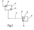
- FIG Realization of the vehicle control and Route guidance system shown schematically. Same Parts as in Figure 1 are given the same reference numerals provided and not explained again.
- the autonomous navigation system 35 of the vehicle before the start of the journey via the communication link 14 with the service center 12 in connection occurs.
- the communication link 14 can in this case a wired connection, for example a telephone line, broadband cable or something like that.
- the already 1 explained radio connection to the service center 12 are manufactured.
- the navigation system 35 has an interface 36 through which one Communication with the service center 12 is possible.
- the service center is accessed via an input unit 38 12 communicated the destination B.
- the navigation system 35 has a storage unit 38 in which the route 16 corresponds transferred navigation information can be saved are. Because loading Route 16 into the storage unit can be done just before the start of the journey the latest traffic information 18 from the computer 17 can be taken into account when planning the optimal route 16.
- either the storage unit 38 of the navigation system 35 portable trained, for example in the form of a floppy disk or a recordable CD-ROM or DVD that is used for Storage of the current route 16 in the corresponding Data processing devices can be introduced or the navigation system 35 is via the interface 36 directly with the communication link 14 connectable. Since only the current route 16 in the storage unit 38 is loaded, the storage capacity kept to a minimum because the entire map 10 (FIG. 1) with all possible destinations saved needs to be.
- the storage unit 38 can be provided that the storage unit 38 several, usually as standard routes saved routes used by the vehicle.
- the service center 12 By connecting to the service center 12 briefly Before the start of the journey, there is an update of the Route 16, the service center 12 being available standing current traffic information 18 the planning of route 16 can be taken into account. Also here are the advantages that not all available road network with all possible Store travel destinations in the navigation system 35 is.
- a combination is that in the exemplary embodiments possible according to Figures 1 and 2 vehicle guidance and guidance systems. So can before setting off on a selected destination B corresponding route 16 via a wired Communication link 14, for example via ISDN, can be loaded into the navigation system 35. During the departure of Route 16 from starting point A Destination B becomes a self-location of the vehicle the current location from the service center 12 monitors. Only if in the meantime, that is called Route 16 after loading, in detail the route 16 touching areas 20 to 30 due to current Traffic information 18 Route changes 16 result in a corresponding data exchange and thus correction of route 16 in the navigation system 35. This will facilitate data exchange during the Travel limited to an absolutely necessary minimum. The data exchange only refers to possibly required changes in route 16.
- the invention is of course limited not on the illustrated embodiments. So is possible, for example, instead of a destination B Several destinations before the start of the journey, for example looking after customers of a sales representative, or for freight forwarders, the service center 12 the optimal route 16 determined for the departure of the several destinations.
Abstract
Description
Die Erfindung betrifft ein Fahrzeugleit- und Zielführungssystem mit den im Oberbegriff des Anspruchs 1 genannten Merkmalen.The invention relates to a vehicle guidance and guidance system with those in the preamble of claim 1 mentioned features.
Zur Zielführung von Fahrzeugen sind fahrzeugfeste Navigationssysteme bekannt. Diese nutzen ein im Fahrzeug mitgeführtes, für die Navigation erforderliches Kartenmaterial, um das Fahrzeug zu einem vom Fahrzeugführer vorgebbaren Zielpunkt zu leiten. Es sind alle für die gesamte Route benötigten Informationen im Fahrzeug gespeichert. Hierbei ist nachteilig, daß entsprechend der Vielzahl unterschiedlicher Zielpunkte über ein relativ großes Territorium entsprechend große Speicherkapazitäten für die Navigationsinformationen vorzuhalten sind. Darüber hinaus ist nachteilig, daß eine Berücksichtigung aktueller, die Zielführung eines Fahrzeuges beeinflussender Informationen, beispielsweise Umleitungen, Straßensperrungen und so weiter, nicht berücksichtigbar sind. For vehicle guidance, vehicles are fixed Known navigation systems. These use one in the vehicle carried, necessary for navigation Maps to get the vehicle to one from the driver to guide the predefinable target point. There are all the information needed for the entire route stored in the vehicle. The disadvantage here is that corresponding to the multitude of different target points over a relatively large territory accordingly large storage capacities for navigation information are to be kept. Beyond that disadvantageous that a consideration of current, the Guidance of a vehicle influencing information, for example detours, road closures and so on, are not considered.
Ferner sind übergeordnete Dienstesysteme zur Bereitstellung von Navigationsinformationen bekannt, mittels denen eine, eine von einem Fahrzeugführer vorgebbaren Zielpunkten entsprechende Route an ein fahrzeugfestes Navigationssystem übertragbar sind. Hierbei wird entsprechend des gewünschten Zielpunktes die gesamte Navigationsinformation übertragen. Nachteilig ist hierbei, daß einerseits eine relativ große Informationsmenge zu übertragen ist und andererseits sich während der Abfahrt der Route ergebende Änderungen nicht mehr berücksichtigbar sind.Superordinate service systems are also available known from navigation information, by means of which one, a target point that can be specified by a driver corresponding route to a vehicle-specific navigation system are transferable. This is done according to the desired Transfer all navigation information to the destination. The disadvantage here is that on the one hand a relatively large Amount of information to be transferred and on the other hand Changes made during the departure of the route are not are more considerable.
Unter Route wird ein Ausschnitt aus einer im fahrzeugfesten Navigationssystem verwendbaren digitalen Karte mit mindestens einem Ziel verstanden. Zur Zielführung muß sich ein Fahrzeug auf digitaler Karte, das heißt der Route befinden.Under Route is a section from one in the vehicle Navigation system with usable digital map understood at least one goal. The route must be a vehicle on a digital map, i.e. the route are located.
Darüber hinaus sind Fahrzeugleit- und Zielführungssysteme bekannt, die entlang eines Fahrweges ortsfest angeordnete Verkehrsleiteinrichtungen aufweisen, mittels denen die Verkehrsleiteinrichtungen passierenden Fahrzeugen Navigationsinformationen eentsprechend einer gewünschten Route übertragbar sind.In addition, there are vehicle guidance and route guidance systems known, the fixedly arranged along a route Have traffic control devices, by means of which the Traffic control vehicles passing vehicles Navigation information according to a desired one Route are transferable.
Das erfindungsgemäße Fahrzeugleit- und Zielführungssystem bietet den Vorteil, daß mittels einem relativ einfach aufgebauten fahrzeugfesten Navigationssystem, das eine Eigenortung des Fahrzeuges, beispielsweise mit GPS, umfaßt, und einem mit diesem kommunizierenden Dienstesystem für eine Routenführung relativ geringe Informationsmengen ausgetauscht werden, wobei eine leistungsfähige dynamische Zielführung, das heißt, eine aktuelle Änderungen während der Abfahrt der Route berücksichtigende Übergabe von Navigationsinformationen möglich ist. Dadurch, daß das Navigationssystem eine Eingabeeinheit umfaßt über die ein Fahrziel eingebbar ist, eine sich hieraus ergebende Route von dem Dienstesystem ermittelbar ist, und die Route abschnittsweise dem Navigationssystem zur Information des Fahrzeugführers bereitgestellt wird, ist vorteilhaft möglich, eine notwendige Speicherkapazität des fahrzeugfesten Navigationssystems auf die Speicherung der vom Dienstsystem bereitgestellten Routenabschnitte auszulegen. Durch die die Gesamtroute ergebende abschnittsweise Übertragung der Routenabschnitte können vor Erreichen des Endzieles, sich in einem nachfolgenden, noch zu durchfahrenden Routenabschnitt ergebende Änderungen berücksichtigt, und dem fahrzeugfesten Navigationssystem übergeben werden. Es können somit dynamische Navigationsinformationen, welche vom aktuellen Standort des Fahrzeuges noch relativ weit entfernt sind, für die Gesamtroute berücksichtigt werden, ohne daß hierzu einerseits Speicherkapazitäten des fahrzeugfesten Navigationssystems und zusätzliche Datenübertragungskapazitäten für die Kommunikation des fahrzeugfesten Navigationssystems mit der Dienstezentrale in Anspruch genommen werden. Erst wenn der aktuelle Standort des Fahrzeuges in einen nächsten Routenabschnitt übergeht, wird der dann bereits von der Dienstezentrale aktualisierte Routenabschnitt dem Navigationssystem des Fahrzeuges übertragen. The vehicle guidance and guidance system according to the invention offers the advantage of being relatively simple built-on vehicle-mounted navigation system, the one Self-location of the vehicle, for example with GPS, includes and a service system communicating with this for one Route guidance relatively small amounts of information be exchanged, being a powerful dynamic route guidance, that is, a current one Taking into account changes during the departure of the route Transfer of navigation information possible is. Because the navigation system has an input unit includes a destination can be entered, a resulting route from the service system can be determined, and the route in sections the navigation system to inform the driver is provided is advantageously possible a necessary storage capacity of the vehicle-fixed Navigation system on the storage of the To design service sections provided route sections. Through the section by section which gives the overall route Transfer of route sections can before reaching the final goal, in a subsequent, resulting route section still to be traveled Changes taken into account, and the vehicle-fixed Navigation system will be handed over. It can thus dynamic navigation information, which from current location of the vehicle is still relatively far are taken into account for the overall route without storage capacities of the vehicle-mounted navigation system and additional Data transmission capacities for communication of the vehicle-mounted navigation system with the Service center can be used. First if the current location of the vehicle in one next section of the route, then Route section already updated by the service center transmitted to the navigation system of the vehicle.
Das Fahrzeugleit- und Zielführungssystem mit den im Anspruch 9 genannten Merkmalen bietet den Vorteil, daß unmittelbar vor Antritt das fahrzeugfeste Navigationsssystem entsprechend eines wählbaren Fahrzieles mit einer aktuellen Route geladen werden kann. Dadurch, daß das Navigationssystem vor Fahrtantritt mit dem Dienstesystem zur Kommunikation in Verbindung bringbar ist, wobei entsprechend eines vorgebbaren Fahrzieles von dem Dienstesystem die aktuellste, sich aus dem vorgebbaren Fahrziel ergebende Route dem Navigationssystem überspielt wird, ist vorteilhaft möglich, alle sich bis Fahrtantritt ergebenden Verkehrsinformationen bei der Festlegung der Fahrtroute zu berücksichtigen. Das fahrzeugfeste Navigationssystem braucht einerseits keine große Speicherkapazität zur Festlegung von Routen zu allen eventuell möglichen Fahrzielen zu besitzen, da lediglich nur die dem tatsächlichen Fahrziel zuzuordnende aktuelle Route überspielt und abgespeichert zu werden braucht. Darüber hinaus lassen sich so kurzfristig, bis Fahrtantritt, eintretende Verkehrsinformationen, beispielsweise Straßensperrungen, Verkehrsaufkommen, Verkehrsprognosen und ähnliches, bei der Festlegung der Route berücksichtigen. Bevorzugt ist, wenn das Navigationssystem mit dem Dienstesystem über einen Telekommunikationsdienst, beispielsweise ein leitungsgebundenes oder leitungsloses Telekommunikationsnetz, zur Überspielung in Verbindung bringbar ist.The vehicle guidance and route guidance system with the im Features mentioned claim 9 has the advantage that immediately before starting the vehicle-mounted navigation system according to a selectable destination can be loaded with a current route. Thereby, that the navigation system with before starting the journey the service system for communication in connection can be brought, according to a predetermined Destination of the service system the most current, itself route resulting from the predefinable destination Navigation system is dubbed is advantageous possible, all traffic information resulting up to the start of the journey when determining the route to consider. The vehicle-mounted navigation system on the one hand, does not need a large storage capacity to define routes to all possible To own destinations, since only those current route to be assigned to the actual destination needs to be dubbed and saved. About that can also be used at short notice until the start of the journey, incoming traffic information, for example Road closures, traffic volume, traffic forecasts and the like when determining the route consider. It is preferred if the navigation system with the service system via a telecommunication service, for example a wired one or wireless telecommunications network, for dubbing is connectable.
In weiterer bevorzugter Ausgestaltung der Erfindung ist vorgesehen, daß im fahrzeugfesten Navigationssystem bestimmte wählbare, beispielsweise wiederkehrende Routen, abspeicherbar sind. Vor Fahrtantritt wird über die Kommunikationsverbindung mit dem Dienstesystem die entsprechend dem tatsächlichen Fahrziel entsprechende Route als Update aktualisiert. Hierdurch ergibt sich ebenfalls eine dynamische, das heißt relativ aktuelle Verkehrsinformationen berücksichtigende, Navigationsinformation für das Kraftfahrzeug.In a further preferred embodiment of the invention it is provided that in the vehicle-mounted navigation system certain selectable, e.g. recurring Routes that can be saved. Before departure over the communication link with the service system which correspond to the actual destination Corresponding route updated as an update. Hereby there is also a dynamic that means relatively current traffic information, Navigation information for the motor vehicle.
Weitere vorteilhafte Ausgestaltungen der Erfindung ergeben sich aus den übrigen, in den Unteransprüchen genannten Merkmalen.Further advantageous embodiments of the invention result from the rest, in the subclaims mentioned features.
Die Erfindung wird nachfolgend in Ausführungsbeispielen anhand der zugehörigen Zeichnungen näher erläutert. Es zeigen:
- Figur 1
- eine schematische Ansicht eines Fahrzeugleit- und Zielführungssystems in einem ersten Ausführungsbeispiel und
- Figur 2
- eine schematische Darstellung eines Fahrzeugleit- und Zielführungssystems in einer zweiten Ausführungsvariante.
- Figure 1
- a schematic view of a vehicle guidance and route guidance system in a first embodiment and
- Figure 2
- a schematic representation of a vehicle control and guidance system in a second embodiment.
In Figur 1 ist schematisch eine Landkarte 10 gezeigt,
anhand der das erfindungsgemäße Fahrzeugleit- und
Zielführungssystem erläutert werden soll. Im Beispiel
wird davon ausgegangen, daß ein nicht dargestelltes
Kraftfahrzeug von einem Ausgangspunkt A zu einem
Fahrziel B gelangen möchte. Am Ausgangspunkt A gibt
der Fahrzeugführer des Fahrzeuges an seinem fahrzeugfesten
Navigationssystem das Fahrzeugziel B ein.
Hierauf tritt das Navigationssystem mit einer Dienstezentrale
12 in eine Kommunikationsverbindung 14.
Die Kommunikationsverbindung 14 kann beispielsweise
über ein Mobilfunknetz erfolgen. Hierzu besitzen
sowohl das Fahrzeug als auch die Dienstezentrale eine
Empfangs- und Sendeeinrichtung 13.A
Das Dienstesystem 12 führt die Information, das
heißt, das genannte Fahrziel B, einem Rechner 17 zu,
der anhand einer im Rechner 17 abgespeicherten, detaillierten
Karte der gesamten Landkarte 10 eine
optimale Route 16 zum Erreichen des Fahrzieles B
errechnet. Diese Route 16 ergibt sich einerseits aus
der abgespeicherten Landkarte 10 und zusätzlichen
aktuellen externen Verkehrsinformationen 18, mit dem
die Dienstezentrale 12 fortlaufend versorgt wird. Die
Verkehrsinformationen 18 können beispielsweise Hinweise
auf gesperrte Straßen, Staustrecken, schwierige
Witterungsverhältnisse und ähnliches sein.The
Unter Berücksichtigung der Verkehrsinformation 18 und
der Landkarte 10 wird die Route 16 dem Fahrzeug
abschnittsweise über die Kommunikationsverbindung 14
übertragen. Die einzelnen Abschnitte der Route 16 die
dem Fahrzeug übertragen werden, richten sich nach
einer zuvor festgelegten Einteilung der Landkarte 10.
Die Landkarte 10 ist hierzu in bestimmte Bereiche
eingeteilt, von denen hier beispielsweise ein Bereich
20, ein Bereich 22, ein Bereich 24, ein Bereich 26,
ein Bereich 28 und ein Bereich 30 genannt sind. Die
Einteilung der Bereiche 20 bis 30 und auch der
weiteren nicht bezeichneten Bereiche kann beispielsweise
nach geographischen Gegebenheiten, verwaltungsorganisatorischen
Gegebenheiten (Kreise, Städte,
Gemeinden und so weiter) oder anderen frei wählbaren
Kriterien erfolgen. Die einzelnen Bereiche 20 bis 30
grenzen jeweils an Übergangspunkten 32 aneinander an.
(Aus Gründen der Übersichtlichkeit ist in Figur 1 nur
ein Übergangspunkt 32 dargestellt, wobei klar ist,
daß diese zwischen allen Bereichen der Landkarte 10
existieren.) Vorteilhaft ist die Einteilung der Bereiche
anhand von fahrtspezifischen Randbedingungen.
Beispielsweise kann eine Teilroute bei einer Fernfahrt
auf Autobahnen auf den Bereich der Autobahn
beschränkt sein und ein großes Gebiet abdecken. Bei
einer Stadtfahrt wird die Route alle Straßen und ein
kleines Gebiet abdecken.Taking
Entsprechend der Anforderung des Fahrzeuges, das vom
Ausgangspunkt A zum Fahrziel B gelangen wird, wird in
der Dienstezentrale 12 die für dieses Fahrzeug günstigste
Route 16 ermittelt und separat erfaßt und in
der Dienstezentrale 12 abgespeichert. Zum Beispiel
verläuft die Route 16 über die Bereiche 20, 22, 24,
26, 28 und 30. Zunächst wird dem Navigationssystem
des Fahrzeuges ein erster Abschnitt 34 der Route 16
überspielt, der dem Verlauf der Route 16 in dem Bereich
20 zuzuordnen ist. Hierzu erfolgt beispielsweise
eine Übertragung einer detaillierten digitalen
Karte an das Navigationssystem des Fahrzeuges, wobei
diese sich ausschließlich auf den Bereich 20 bezieht.
Da das Navigationssystem des Fahrzeuges nicht die
gesamte detaillierte Landkarte 10, sondern nur den
Bereich 20 erfassen und zwischenspeichern muß, ist
eine entsprechend geringe Speicherkapazität vorzusehen.
Für das Navigationssystem des Fahrzeuges wird
zunächst der Übergangspunkt 32 zwischen dem Bereich
20 und 22 als autonomes Zwischenziel vorgegeben. Das
bedeutet, der Fahrzeugführer des Fahrzeuges erhält
von diesem Zwischenziel keine Kenntnis, da er ja zum
Fahrziel B gelangen will. Für das Navigationssystem
des Fahrzeuges jedoch ist zunächst das autonome
Zwischenziel am Übergangspunkt 32 zwischen den Bereichen
20 und 22 das scheinbare Fahrziel.According to the requirement of the vehicle which is from
Starting point A will get to destination B is in
the
Das Navigationssystem des Fahrzeuges selber kann auf unterschiedliche Art und Weise die notwendigen Informationen an den Fahrzeugführer weitergeben, beispielsweise durch Anzeigen einer entsprechenden Karte auf einem Display, durch digitale Sprachhinweise oder andere digitale oder analoge Hinweise zum Führen des Fahrzeuges.The navigation system of the vehicle itself can be opened different ways the necessary information pass it on to the driver, for example by displaying a corresponding map on a display, through digital voice prompts or other digital or analog instructions for operating the Vehicle.
Über eine Selbstortung des Fahrzeuges erkennt das
Dienstesystem 12 eine Annäherung des Fahrzeuges an
den Übergangspunkt 32 zwischen den Bereichen 20 und
22. Mit Erreichen des Übergangspunktes 32 oder kurz
vor Erreichen des Übergangspunktes 32 wird dem Navigationssystem
des Fahrzeuges über die Empfangs- und
Sendeeinrichtung 13 der nächste Abschnitt der Route
16, der, im gezeigten Beispiel, im Bereich 22 verläuft
überspielt. Da der Bereich 20 bereits abgefahren
ist, können die sich hierauf beziehenden Navigationsinformationen
gelöscht werden. Somit wird keine
zusätzliche Speicherkapazität benötigt.This is recognized by a self-location of the
Da der auf den Bereich 22 fallende Abschnitt der
Route 16 erst mit Erreichen des Übergangspunktes 32
dem Navigationssytem überspielt wird, können zwischenzeitliche,
das heißt, seit Fahrtantritt am Ausgangspunkt
A eingegangene, Verkehrsinformationen 18
vom Rechner 17 verarbeitet und bei der aktuellen
Festlegung der noch abzufahrenden Route 16 berücksichtigt
werden. Insofern kann sich die interne, das
heißt die in der Dienstezentrale 12 zunächst festgelegte
Route während des tatsächlichen Abfahrens der
Route 16 ändern, ohne daß der Fahrzeugführer hiervon
Kenntnis erlangt. Mit Erreichen des Übergangspunktes
32 zwischen den Bereichen 22 und 24 erfolgt in analoger
Weise das Überspielen des nächsten Abschnittes
der Route 16, das heißt, in diesem Fall der auf den
Bereich 24 fallende Abschnitt, von der Dienstezentrale
12 zu dem Navigationssystem des Fahrzeuges. Diese
Verfahrensweise wird fortgeführt, bis das Fahrziel B
erreicht ist.Since the section falling on the
Insgesamt ergibt sich der Vorteil, daß durch das
erfindungsgemäße Fahrzeugleit- und Zielführungssystem
sich eine Aufgabenteilung der Navigation zwischen dem
Navigationssystem des Fahrzeuges und der Dienstezentrale
12 ergibt. Die verhältnismäßig aufwendige Berechnung
der Route 16 und deren laufende Aktualisierung,
auch nach bereits erfolgtem Start am Ausgangspunkt
A, erfolgt durch den leistungsfähigen Rechner
17 der Dienstezentrale 12. Somit ist eine dynamische
Zielführung des Fahrzeuges möglich, da aktuelle Verkehrsinformationen
18 bei Festlegung beziehungsweise
Änderung der Route 16 berücksichtigbar sind. Das
autonome Navigationssystem des Fahrzeuges braucht
lediglich eine geringe Speicherkapazität vorzuhalten,
da die Route nur abschnittsweise, auf die erläuterten
Bereiche 20 bis 30 bezogen, abzuspeichern ist. Das
Navigationssystem erfaßt lediglich autonome Zwischenziele
an den Übergangspunkten 32, die für den Fahrzeugführer
nicht erkennbar sind, da diese für das
Erreichen des Endzieles B untergeordnet sind.Overall, there is the advantage that
Vehicle guidance and guidance system according to the invention
a division of tasks in navigation between the
Navigation system of the vehicle and the
Über eine Selbstortung der Fahrzeuge durch das Dienstesystem
12 wird eine Abweichung des Fahrzeuges von
der vorgegebenen Route 16 erfaßt, so daß auf eine
sich hierdurch ergebende eventuelle Änderung der
Route 16 bei der Bereitstellung der Navigationsinformationen
sofort Einfluß genommen werden kann. Entweder
erfolgt ein Hinweis an den Fahrzeugführer, daß
die vorgegebene, optimale Route 16 verlassen wurde,
oder es wird intern, das heißt, für den Fahrzeugführer
nicht erkennbar, eine neue Route 16 erstellt und
dem Navigationssystem überspielt. Sich aus der Änderung
der Route 16 ergebende Änderungen in nachfolgenden
Bereichen 20 bis 30 der Route werden zunächst
intern vom Dienstesystem 12 berücksichtigt, da die in
den später zu durchfahrenden Bereichen 20 bis 30 sich
ergebenden Abschnitte der Route 16 erst mit Erreichen
des jeweiligen Übergangspunktes 32 dem Navigationssystem
übergeben werden. Via a self-location of the vehicles by the
In Figur 2 ist eine weitere Ausführungsvariante zur Realisierung des erfindungsgemäßen Fahrzeugleit- und Zielführungssystems schematisch dargestellt. Gleiche Teile wie in Figur 1 sind mit gleichen Bezugszeichen versehen und nicht nochmals erläutert.A further embodiment variant is shown in FIG Realization of the vehicle control and Route guidance system shown schematically. Same Parts as in Figure 1 are given the same reference numerals provided and not explained again.
Gemäß dem in Figur 2 erläuterten Ausführungsbeispiel
ist vorgesehen, daß das autonome Navigationssystem 35
des Fahrzeuges vor Fahrtantritt über die Kommunikationsverbindung
14 mit der Dienstezentrale 12 in Verbindung
tritt. Die Kommunikationsverbindung 14 kann
in diesem Fall eine leitungsgebundene Verbindung,
beispielsweise eine Telefonleitung, Breitbandkabel
oder ähnliches sein. Darüber hinaus kann die bereits
zu Figur 1 erläuterte Funkverbindung zu der Dienstezentrale
12 hergestellt werden. Das Navigationssystem
35 besitzt eine Schnittstelle 36, über die eine
Kommunikation mit der Dienstezentrale 12 möglich ist.
Über eine Eingabeeinheit 38 wird der Dienstezentrale
12 das Fahrziel B mitgeteilt. Hierauf wird von dem
Rechner 17 der Dienstezentrale 12 die optimale Route
16 ermittelt und dem Navigationssystem 35 übertragen.
Das Navigationssystem 35 besitzt eine Speichereinheit
38, in der die der Route 16 entsprechenden
übergebenen Navigationsinformationen speicherbar
sind. Da ein Laden der Route 16 in die Speichereinheit
kurz vor Fahrtbeginn erfolgen kann, sind die
aktuellsten Verkehrsinformationen 18 vom Rechner 17
bei der Planung der optimalen Route 16 berücksichtigbar. According to the exemplary embodiment explained in FIG. 2
it is provided that the
Zur praktischen Realisierung ist entweder die Speichereinheit
38 des Navigationssystemes 35 transportabel
ausgebildet, beispielsweise in Form einer Diskette
oder beschreibbaren CD-ROM oder DVD, die zur
Aufspeicherung der aktuellen Route 16 in entsprechende
Datenverarbeitungsgeräte einbringbar sind
oder das Navigationssystem 35 ist über die Schnittstelle
36 direkt mit der Kommunikationsverbindung 14
koppelbar. Da jeweils nur die aktuelle Route 16 in
die Speichereinheit 38 geladen wird, kann die Speicherkapazität
auf ein notwendiges Minimum beschränkt
werden, da nicht die gesamte Landkarte 10 (Figur 1)
mit allen eventuell möglichen Fahrzielen gespeichert
zu sein braucht.For practical implementation, either the
Gegebenenfalls kann vorgesehen sein, daß die Speichereinheit
38 mehrere, in der Regel als Standartrouten
von dem Fahrzeug benutzte Routen gespeichert hat.
Durch die Verbindung mit der Dienstezentrale 12 kurz
vor Fahrtantritt erfolgt dann jeweils ein Update der
Route 16, wobei die der Dienstezentrale 12 zur Verfügung
stehenden aktuellen Verkehrsinformationen 18 bei
der Planung der Route 16 berücksichtigbar sind. Auch
hier ergeben sich die Vorteile, daß nicht das gesamte
zur Verfügung stehende Straßennetz mit allen möglichen
Fahrzielen im Navigationssystem 35 abzuspeichern
ist.If necessary, it can be provided that the
Ferner ist eine Kombination der in den Ausführungsbeispielen
gemäß Figur 1 und 2 erläuterten Fahrzeugleit- und Zielführungssysteme möglich. So kann
vor Fahrtantritt eine einem gewählten Fahrziel B
entsprechende Route 16 über eine leitungsgebundene
Kommunikationsverbindung 14, beispielsweise über
ISDN, in das Navigationssystem 35 geladen werden.
Während der Abfahrt der Route 16 vom Ausgangspunkt A
zum Fahrziel B wird über eine Selbstortung des Fahrzeuges
der aktuelle Standort von der Dienstezentrale
12 überwacht. Nur wenn sich in der Zwischenzeit, das
heißt nach dem Laden Route 16, im einzelnen die Route
16 berührenden Bereichen 20 bis 30 aufgrund aktueller
Verkehrsinformationen 18 Änderungen der Route 16
ergeben, erfolgt ein entsprechender Datenaustausch
und somit Korrektur der Route 16 im Navigationssystem
35. Hierdurch wird der Datenaustausch während der
Fahrt auf ein unbedingt notwendiges Minimum begrenzt.
Der Datenaustausch bezieht sich lediglich auf eventuell
erforderliche Änderungen in der Route 16.Furthermore, a combination is that in the exemplary embodiments
possible according to Figures 1 and 2 vehicle guidance and guidance systems. So can
before setting off on a selected destination
Die Erfindung beschränkt sich selbstverständlich
nicht auf die erläuterten Ausführungsbeispiele. So
ist beispielsweise möglich, anstelle eines Fahrzieles
B vor Fahrtbeginn mehrere Fahrziele, beispielsweise
bei der Betreuung von Kunden eines Außendienstmitarbeiters,
beziehungsweise bei Speditionen, einzugeben,
wobei die Dienstezentrale 12 die optimale Route 16
zur Abfahrt der mehreren Fahrziele ermittelt.The invention is of course limited
not on the illustrated embodiments. So
is possible, for example, instead of a destination
B Several destinations before the start of the journey, for example
looking after customers of a sales representative,
or for freight forwarders,
the
Claims (13)
Applications Claiming Priority (2)
| Application Number | Priority Date | Filing Date | Title |
|---|---|---|---|
| DE19737256 | 1997-08-27 | ||
| DE19737256A DE19737256B4 (en) | 1997-08-27 | 1997-08-27 | Vehicle guidance and guidance system |
Publications (3)
| Publication Number | Publication Date |
|---|---|
| EP0899704A2 true EP0899704A2 (en) | 1999-03-03 |
| EP0899704A3 EP0899704A3 (en) | 2000-07-05 |
| EP0899704B1 EP0899704B1 (en) | 2004-11-03 |
Family
ID=7840283
Family Applications (1)
| Application Number | Title | Priority Date | Filing Date |
|---|---|---|---|
| EP98114149A Expired - Lifetime EP0899704B1 (en) | 1997-08-27 | 1998-07-29 | Control and navigation method for vehicle |
Country Status (4)
| Country | Link |
|---|---|
| US (1) | US6334089B2 (en) |
| EP (1) | EP0899704B1 (en) |
| DE (2) | DE19737256B4 (en) |
| ES (1) | ES2231921T3 (en) |
Cited By (6)
| Publication number | Priority date | Publication date | Assignee | Title |
|---|---|---|---|---|
| EP1069405A2 (en) | 1999-07-14 | 2001-01-17 | Kabushiki Kaisha Equos Research | Navigation method and system |
| FR2833698A1 (en) * | 2001-12-18 | 2003-06-20 | Bosch Gmbh Robert | Method for determining route data for navigation equipment, comprises decomposition of route into stages and transmission of main and subsidiary data for each stage just before it is commenced |
| EP1333692A2 (en) * | 2002-02-01 | 2003-08-06 | Robert Bosch Gmbh | Communication device having Instant Messenger function |
| EP1436760A1 (en) * | 2001-03-29 | 2004-07-14 | Wingcast, LLC | System and method for reducing the amount of repetitive data |
| US7801731B2 (en) | 2001-10-26 | 2010-09-21 | Intellisist, Inc. | Systems and methods for processing voice instructions in a vehicle |
| US8249880B2 (en) | 2002-02-14 | 2012-08-21 | Intellisist, Inc. | Real-time display of system instructions |
Families Citing this family (72)
| Publication number | Priority date | Publication date | Assignee | Title |
|---|---|---|---|---|
| US6292743B1 (en) | 1999-01-06 | 2001-09-18 | Infogation Corporation | Mobile navigation system |
| EP1190407B2 (en) * | 1999-06-01 | 2009-02-18 | Continental Automotive Systems US, Inc. | Portable driver information device |
| US20040215387A1 (en) | 2002-02-14 | 2004-10-28 | Matsushita Electric Industrial Co., Ltd. | Method for transmitting location information on a digital map, apparatus for implementing the method, and traffic information provision/reception system |
| JP3481168B2 (en) * | 1999-08-27 | 2003-12-22 | 松下電器産業株式会社 | Digital map location information transmission method |
| EP1147374B1 (en) * | 1999-10-19 | 2012-08-01 | MITAC International Corporation | Portable vehicle navigation system |
| JP3494143B2 (en) * | 1999-11-18 | 2004-02-03 | トヨタ自動車株式会社 | Route guidance information providing system and route guidance information providing method |
| DE10007348C2 (en) * | 2000-02-18 | 2003-07-10 | Harman Becker Automotive Sys | navigation system |
| DE10014981A1 (en) * | 2000-03-25 | 2002-02-07 | Bosch Gmbh Robert | Method and device for data transmission and storage for a navigation device |
| DE10021171A1 (en) * | 2000-04-29 | 2001-11-15 | Bosch Gmbh Robert | Navigation method and device |
| DE10032921A1 (en) | 2000-07-06 | 2002-01-24 | Bosch Gmbh Robert | Method of determining and outputting driving instructions to a motor vehicle for following a navigational route |
| US6591188B1 (en) * | 2000-11-01 | 2003-07-08 | Navigation Technologies Corp. | Method, system and article of manufacture for identifying regularly traveled routes |
| CN101271631A (en) * | 2000-12-08 | 2008-09-24 | 松下电器产业株式会社 | Position information identifier providing system, and position information identifier transmitting method and device |
| JP5041638B2 (en) | 2000-12-08 | 2012-10-03 | パナソニック株式会社 | Method for transmitting location information of digital map and device used therefor |
| US20030009280A1 (en) * | 2001-01-05 | 2003-01-09 | Alcatel | Navigation method and navigation system |
| JP4663136B2 (en) | 2001-01-29 | 2011-03-30 | パナソニック株式会社 | Method and apparatus for transmitting location information of digital map |
| US6885735B2 (en) | 2001-03-29 | 2005-04-26 | Intellisist, Llc | System and method for transmitting voice input from a remote location over a wireless data channel |
| USRE46109E1 (en) | 2001-03-29 | 2016-08-16 | Lg Electronics Inc. | Vehicle navigation system and method |
| US7236777B2 (en) | 2002-05-16 | 2007-06-26 | Intellisist, Inc. | System and method for dynamically configuring wireless network geographic coverage or service levels |
| US8175886B2 (en) | 2001-03-29 | 2012-05-08 | Intellisist, Inc. | Determination of signal-processing approach based on signal destination characteristics |
| WO2002082405A1 (en) * | 2001-04-03 | 2002-10-17 | Magellan Dis, Inc. | Vehicle navigation system with portable personal computer |
| JP4749594B2 (en) * | 2001-04-27 | 2011-08-17 | パナソニック株式会社 | Digital map location information transmission method |
| JP4230132B2 (en) * | 2001-05-01 | 2009-02-25 | パナソニック株式会社 | Digital map shape vector encoding method, position information transmission method, and apparatus for implementing the same |
| US20100241342A1 (en) * | 2009-03-18 | 2010-09-23 | Ford Global Technologies, Llc | Dynamic traffic assessment and reporting |
| US6922593B2 (en) * | 2001-08-06 | 2005-07-26 | Gideon Weiss | Control of items in a complex system by using fluid models and solving continuous linear programs |
| US8977284B2 (en) | 2001-10-04 | 2015-03-10 | Traxcell Technologies, LLC | Machine for providing a dynamic data base of geographic location information for a plurality of wireless devices and process for making same |
| JP2003114133A (en) * | 2001-10-05 | 2003-04-18 | Pioneer Electronic Corp | Communication navigation method, communication navigation system, and terminal apparatus |
| DE10200758A1 (en) * | 2002-01-10 | 2003-11-13 | Daimler Chrysler Ag | Method and system for the guidance of vehicles |
| CA2416962A1 (en) * | 2002-01-22 | 2003-07-22 | Datacom Wireless Corporation | Vehicle monitoring system |
| AU2003207082C1 (en) * | 2002-02-07 | 2008-09-18 | Sanyo Electric Co., Ltd. | Navigation system, navigation apparatus and server apparatus |
| AU2003224396A1 (en) | 2002-04-30 | 2003-11-17 | Telmap Ltd. | Navigation system using corridor maps |
| US7243134B2 (en) * | 2002-06-25 | 2007-07-10 | Motorola, Inc. | Server-based navigation system having dynamic transmittal of route information |
| US7433742B2 (en) * | 2002-07-26 | 2008-10-07 | Gideon Weiss | Control of items in a complex system by using fluid models and solving continuous linear programs |
| JP2004085486A (en) * | 2002-08-28 | 2004-03-18 | Honda Motor Co Ltd | Vehicle navigation server |
| CA2520212A1 (en) * | 2003-04-15 | 2004-10-28 | United Parcel Service Of America, Inc. | Rush hour modelling for routing and scheduling |
| US7221928B2 (en) * | 2003-10-01 | 2007-05-22 | Laird Mark D | Mobile emergency notification system |
| JP4189297B2 (en) * | 2003-10-29 | 2008-12-03 | 株式会社ナビタイムジャパン | Route guidance system, portable terminal, server, program, recording medium |
| DE10353108B3 (en) * | 2003-11-12 | 2005-08-04 | Audioton Kabelwerk Gmbh Zweigniederlassung Scheinfeld | Method for supporting the navigation of a vehicle, navigation device and navigation center |
| JP2005180986A (en) * | 2003-12-17 | 2005-07-07 | Honda Motor Co Ltd | Navigation apparatus and navigation server |
| JP4350570B2 (en) * | 2004-03-23 | 2009-10-21 | アルパイン株式会社 | Navigation system, in-vehicle navigation device, and navigation information acquisition method |
| DE102004019232B4 (en) * | 2004-04-16 | 2006-04-06 | Deutsche Post Ag | Method and apparatus for conveying a plurality of physical objects |
| US7373244B2 (en) * | 2004-04-20 | 2008-05-13 | Keith Kreft | Information mapping approaches |
| US7251561B2 (en) * | 2004-07-28 | 2007-07-31 | Telmap Ltd. | Selective download of corridor map data |
| US7908080B2 (en) * | 2004-12-31 | 2011-03-15 | Google Inc. | Transportation routing |
| JP2008543695A (en) * | 2005-05-09 | 2008-12-04 | ユナイテッド パーセル サービス オブ アメリカ インコーポレイテッド | System and method for routing and scheduling |
| KR100866206B1 (en) * | 2006-07-20 | 2008-10-30 | 삼성전자주식회사 | Apparatus and method for providing customized path guardence using a navigation game |
| US20080039991A1 (en) * | 2006-08-10 | 2008-02-14 | May Reed R | Methods and systems for providing accurate vehicle positioning |
| US7778773B2 (en) * | 2007-05-02 | 2010-08-17 | Toshiba America Research, Inc. | Optimum route planning for service vehicles |
| US20090125229A1 (en) * | 2007-11-14 | 2009-05-14 | Telmap, Ltd. | Corridor mapping with alternative routes |
| US20100057358A1 (en) * | 2008-08-28 | 2010-03-04 | TeleType Co., Inc. | Portable gps map device for commercial vehicle industry |
| US8731814B2 (en) | 2010-07-02 | 2014-05-20 | Ford Global Technologies, Llc | Multi-modal navigation system and method |
| US9846046B2 (en) | 2010-07-30 | 2017-12-19 | Ford Global Technologies, Llc | Vehicle navigation method and system |
| US20120029806A1 (en) * | 2010-07-30 | 2012-02-02 | Ford Global Technologies, Llc | Efficient Navigation Data Downloading |
| US8335643B2 (en) | 2010-08-10 | 2012-12-18 | Ford Global Technologies, Llc | Point of interest search, identification, and navigation |
| JP5212748B2 (en) * | 2010-09-29 | 2013-06-19 | アイシン精機株式会社 | Parking assistance device |
| US8521424B2 (en) | 2010-09-29 | 2013-08-27 | Ford Global Technologies, Llc | Advanced map information delivery, processing and updating |
| US8849552B2 (en) | 2010-09-29 | 2014-09-30 | Ford Global Technologies, Llc | Advanced map information delivery, processing and updating |
| US8483958B2 (en) | 2010-12-20 | 2013-07-09 | Ford Global Technologies, Llc | User configurable onboard navigation system crossroad presentation |
| US8688321B2 (en) | 2011-07-11 | 2014-04-01 | Ford Global Technologies, Llc | Traffic density estimation |
| US8838385B2 (en) | 2011-12-20 | 2014-09-16 | Ford Global Technologies, Llc | Method and apparatus for vehicle routing |
| US8855901B2 (en) | 2012-06-25 | 2014-10-07 | Google Inc. | Providing route recommendations |
| WO2014045146A1 (en) | 2012-09-23 | 2014-03-27 | Telmap Ltd | Inferring user risk profile from travel patterns |
| DE102013200899A1 (en) * | 2013-01-21 | 2014-07-24 | Continental Automotive Gmbh | Method for operating navigation system for e.g. hybrid vehicle, involves recalculating route between start and end segments of subset based on received traffic data when predicted value of selection criterion is greater than preset value |
| US9713963B2 (en) | 2013-02-18 | 2017-07-25 | Ford Global Technologies, Llc | Method and apparatus for route completion likelihood display |
| US9863777B2 (en) | 2013-02-25 | 2018-01-09 | Ford Global Technologies, Llc | Method and apparatus for automatic estimated time of arrival calculation and provision |
| US9047774B2 (en) | 2013-03-12 | 2015-06-02 | Ford Global Technologies, Llc | Method and apparatus for crowd-sourced traffic reporting |
| US8977479B2 (en) | 2013-03-12 | 2015-03-10 | Ford Global Technologies, Llc | Method and apparatus for determining traffic conditions |
| US9874452B2 (en) | 2013-03-14 | 2018-01-23 | Ford Global Technologies, Llc | Method and apparatus for enhanced driving experience including dynamic POI identification |
| DE102013211134A1 (en) | 2013-06-14 | 2014-12-18 | Bayerische Motoren Werke Aktiengesellschaft | Method and navigation system for displaying a driving route on a display device |
| US9585056B2 (en) * | 2014-11-07 | 2017-02-28 | Motorola Solutions, Inc. | Method and apparatus for routing traffic within a communication system |
| DE102015204359A1 (en) * | 2015-03-11 | 2016-09-15 | Robert Bosch Gmbh | Driving a motor vehicle in a parking lot |
| US10449968B2 (en) * | 2016-09-23 | 2019-10-22 | Ford Motor Company | Methods and apparatus for adaptively assisting developmentally disabled or cognitively impaired drivers |
| US10672267B1 (en) | 2019-01-29 | 2020-06-02 | Toyota Motor Engineering & Manufacturing North America, Inc. | Smart notification center |
Citations (2)
| Publication number | Priority date | Publication date | Assignee | Title |
|---|---|---|---|---|
| DE4139581A1 (en) * | 1991-11-30 | 1993-06-03 | Bayerische Motoren Werke Ag | Vehicle navigation system - transmits information w.r.t. starting location and destination to central command station which determines route plans |
| EP0715289A2 (en) * | 1994-11-28 | 1996-06-05 | MANNESMANN Aktiengesellschaft | Method and system for guiding a vehicle |
Family Cites Families (4)
| Publication number | Priority date | Publication date | Assignee | Title |
|---|---|---|---|---|
| JP3385657B2 (en) * | 1993-08-10 | 2003-03-10 | トヨタ自動車株式会社 | Car navigation system |
| US5757289A (en) * | 1994-09-14 | 1998-05-26 | Aisin Aw Co., Ltd. | Vehicular navigation system |
| DE69535394T2 (en) * | 1994-12-28 | 2007-10-31 | Omron Corp. | Traffic Information System |
| DE19623666C1 (en) * | 1996-06-13 | 1997-11-20 | Siemens Ag | Procedure for dynamic route recommendation |
-
1997
- 1997-08-27 DE DE19737256A patent/DE19737256B4/en not_active Expired - Fee Related
-
1998
- 1998-07-29 ES ES98114149T patent/ES2231921T3/en not_active Expired - Lifetime
- 1998-07-29 EP EP98114149A patent/EP0899704B1/en not_active Expired - Lifetime
- 1998-07-29 DE DE59812206T patent/DE59812206D1/en not_active Expired - Lifetime
- 1998-08-26 US US09/141,171 patent/US6334089B2/en not_active Expired - Lifetime
Patent Citations (2)
| Publication number | Priority date | Publication date | Assignee | Title |
|---|---|---|---|---|
| DE4139581A1 (en) * | 1991-11-30 | 1993-06-03 | Bayerische Motoren Werke Ag | Vehicle navigation system - transmits information w.r.t. starting location and destination to central command station which determines route plans |
| EP0715289A2 (en) * | 1994-11-28 | 1996-06-05 | MANNESMANN Aktiengesellschaft | Method and system for guiding a vehicle |
Cited By (11)
| Publication number | Priority date | Publication date | Assignee | Title |
|---|---|---|---|---|
| EP1069405A2 (en) | 1999-07-14 | 2001-01-17 | Kabushiki Kaisha Equos Research | Navigation method and system |
| EP1069405A3 (en) * | 1999-07-14 | 2004-01-14 | Kabushiki Kaisha Equos Research | Navigation method and system |
| EP1436760A1 (en) * | 2001-03-29 | 2004-07-14 | Wingcast, LLC | System and method for reducing the amount of repetitive data |
| EP1436760A4 (en) * | 2001-03-29 | 2005-01-05 | Wingcast Llc | System and method for reducing the amount of repetitive data |
| EP1855087A3 (en) * | 2001-03-29 | 2009-03-11 | Intellisist, Inc. | System and method for reducing the amount of repetitive data |
| US8121781B2 (en) | 2001-03-29 | 2012-02-21 | Wi-Gui, Llp | System and method for reducing the amount of repetitive data sent by a server to a client for vehicle navigation |
| US7801731B2 (en) | 2001-10-26 | 2010-09-21 | Intellisist, Inc. | Systems and methods for processing voice instructions in a vehicle |
| FR2833698A1 (en) * | 2001-12-18 | 2003-06-20 | Bosch Gmbh Robert | Method for determining route data for navigation equipment, comprises decomposition of route into stages and transmission of main and subsidiary data for each stage just before it is commenced |
| EP1333692A2 (en) * | 2002-02-01 | 2003-08-06 | Robert Bosch Gmbh | Communication device having Instant Messenger function |
| EP1333692A3 (en) * | 2002-02-01 | 2003-12-17 | Robert Bosch Gmbh | Communication device having Instant Messenger function |
| US8249880B2 (en) | 2002-02-14 | 2012-08-21 | Intellisist, Inc. | Real-time display of system instructions |
Also Published As
| Publication number | Publication date |
|---|---|
| EP0899704B1 (en) | 2004-11-03 |
| DE19737256B4 (en) | 2005-02-24 |
| US6334089B2 (en) | 2001-12-25 |
| US20010001847A1 (en) | 2001-05-24 |
| EP0899704A3 (en) | 2000-07-05 |
| DE19737256A1 (en) | 1999-03-04 |
| DE59812206D1 (en) | 2004-12-09 |
| ES2231921T3 (en) | 2005-05-16 |
Similar Documents
| Publication | Publication Date | Title |
|---|---|---|
| EP0899704B1 (en) | Control and navigation method for vehicle | |
| DE19912859B4 (en) | Communication-capable navigation system | |
| EP1141910B2 (en) | Navigation method and navigation system for means of locomotion | |
| DE4034681C2 (en) | ||
| EP1955017A1 (en) | Method and system for updating card data of a navigation system | |
| WO2001002806A1 (en) | Method and device for transmitting navigational information from a central data unit to a navigation system, located in a motor-vehicle | |
| DE102007001844A1 (en) | Dynamic vehicle navigation system and method | |
| WO2000037890A1 (en) | Method for leading the user of a vehicle from at least one starting point to at least one point of destination | |
| DE102014008151A1 (en) | Method for operating a motor vehicle | |
| EP0944895B1 (en) | Process for transmitting route information which concerns a route of a vehicle in a road network between a traffic information centre and a terminal in a vehicle, traffic information centre and terminal | |
| EP0803852B1 (en) | Method and device to guide a vehicle | |
| EP1017965B1 (en) | Method for updating a digital road map | |
| DE19935645A1 (en) | Navigation method and navigation device | |
| DE19701370A1 (en) | Extending stored data sets of road network of navigation unit for motor vehicle | |
| EP1342221A1 (en) | Method for automatically deleting a traffic announcement | |
| DE10122448A1 (en) | Method for operating a navigation system for a vehicle, in particular a motor vehicle, and navigation system | |
| DE19758990B3 (en) | DATA RECEIVER AND METHOD FOR DISPLAYING TRAFFIC INFORMATION DATA | |
| EP2205942B1 (en) | Navigation system and method for route planning | |
| DE102006013297B4 (en) | Method for operating a navigation system | |
| DE69815152T2 (en) | NAVIGATION AID DEVICE IN A SYSTEM ON BOARD A VEHICLE | |
| DE10113810A1 (en) | Method for determining an optimum journey plan for a motor vehicle, especially a cross-country vehicle in which previous journey data as well as map data is used in route planning | |
| EP1274058B1 (en) | Navigation method and navigation system | |
| EP1221585A2 (en) | Navigation device | |
| EP1255092A2 (en) | Device and method for displaying information in a vehicle | |
| EP1317654A1 (en) | Device for generating and/or processing navigational information |
Legal Events
| Date | Code | Title | Description |
|---|---|---|---|
| PUAI | Public reference made under article 153(3) epc to a published international application that has entered the european phase |
Free format text: ORIGINAL CODE: 0009012 |
|
| AK | Designated contracting states |
Kind code of ref document: A2 Designated state(s): DE ES FR GB |
|
| AX | Request for extension of the european patent |
Free format text: AL;LT;LV;MK;RO;SI |
|
| PUAL | Search report despatched |
Free format text: ORIGINAL CODE: 0009013 |
|
| AK | Designated contracting states |
Kind code of ref document: A3 Designated state(s): AT BE CH CY DE DK ES FI FR GB GR IE IT LI LU MC NL PT SE |
|
| AX | Request for extension of the european patent |
Free format text: AL;LT;LV;MK;RO;SI |
|
| 17P | Request for examination filed |
Effective date: 20010105 |
|
| AKX | Designation fees paid |
Free format text: DE ES FR GB |
|
| 17Q | First examination report despatched |
Effective date: 20030611 |
|
| GRAP | Despatch of communication of intention to grant a patent |
Free format text: ORIGINAL CODE: EPIDOSNIGR1 |
|
| RTI1 | Title (correction) |
Free format text: CONTROL AND NAVIGATION METHOD FOR VEHICLE |
|
| GRAS | Grant fee paid |
Free format text: ORIGINAL CODE: EPIDOSNIGR3 |
|
| GRAA | (expected) grant |
Free format text: ORIGINAL CODE: 0009210 |
|
| AK | Designated contracting states |
Kind code of ref document: B1 Designated state(s): DE ES FR GB |
|
| REG | Reference to a national code |
Ref country code: GB Ref legal event code: FG4D Free format text: NOT ENGLISH |
|
| REF | Corresponds to: |
Ref document number: 59812206 Country of ref document: DE Date of ref document: 20041209 Kind code of ref document: P |
|
| GBT | Gb: translation of ep patent filed (gb section 77(6)(a)/1977) |
Effective date: 20050221 |
|
| REG | Reference to a national code |
Ref country code: ES Ref legal event code: FG2A Ref document number: 2231921 Country of ref document: ES Kind code of ref document: T3 |
|
| PLBE | No opposition filed within time limit |
Free format text: ORIGINAL CODE: 0009261 |
|
| STAA | Information on the status of an ep patent application or granted ep patent |
Free format text: STATUS: NO OPPOSITION FILED WITHIN TIME LIMIT |
|
| ET | Fr: translation filed | ||
| 26N | No opposition filed |
Effective date: 20050804 |
|
| PGFP | Annual fee paid to national office [announced via postgrant information from national office to epo] |
Ref country code: GB Payment date: 20120723 Year of fee payment: 15 |
|
| PGFP | Annual fee paid to national office [announced via postgrant information from national office to epo] |
Ref country code: ES Payment date: 20120723 Year of fee payment: 15 Ref country code: FR Payment date: 20120803 Year of fee payment: 15 |
|
| GBPC | Gb: european patent ceased through non-payment of renewal fee |
Effective date: 20130729 |
|
| REG | Reference to a national code |
Ref country code: FR Ref legal event code: ST Effective date: 20140331 |
|
| PG25 | Lapsed in a contracting state [announced via postgrant information from national office to epo] |
Ref country code: GB Free format text: LAPSE BECAUSE OF NON-PAYMENT OF DUE FEES Effective date: 20130729 |
|
| PG25 | Lapsed in a contracting state [announced via postgrant information from national office to epo] |
Ref country code: FR Free format text: LAPSE BECAUSE OF NON-PAYMENT OF DUE FEES Effective date: 20130731 |
|
| REG | Reference to a national code |
Ref country code: ES Ref legal event code: FD2A Effective date: 20140908 |
|
| PG25 | Lapsed in a contracting state [announced via postgrant information from national office to epo] |
Ref country code: ES Free format text: LAPSE BECAUSE OF NON-PAYMENT OF DUE FEES Effective date: 20130730 |
|
| PGFP | Annual fee paid to national office [announced via postgrant information from national office to epo] |
Ref country code: DE Payment date: 20160927 Year of fee payment: 19 |
|
| REG | Reference to a national code |
Ref country code: DE Ref legal event code: R119 Ref document number: 59812206 Country of ref document: DE |
|
| PG25 | Lapsed in a contracting state [announced via postgrant information from national office to epo] |
Ref country code: DE Free format text: LAPSE BECAUSE OF NON-PAYMENT OF DUE FEES Effective date: 20180201 |